Ancient site · France · Restored
Pont du Gard
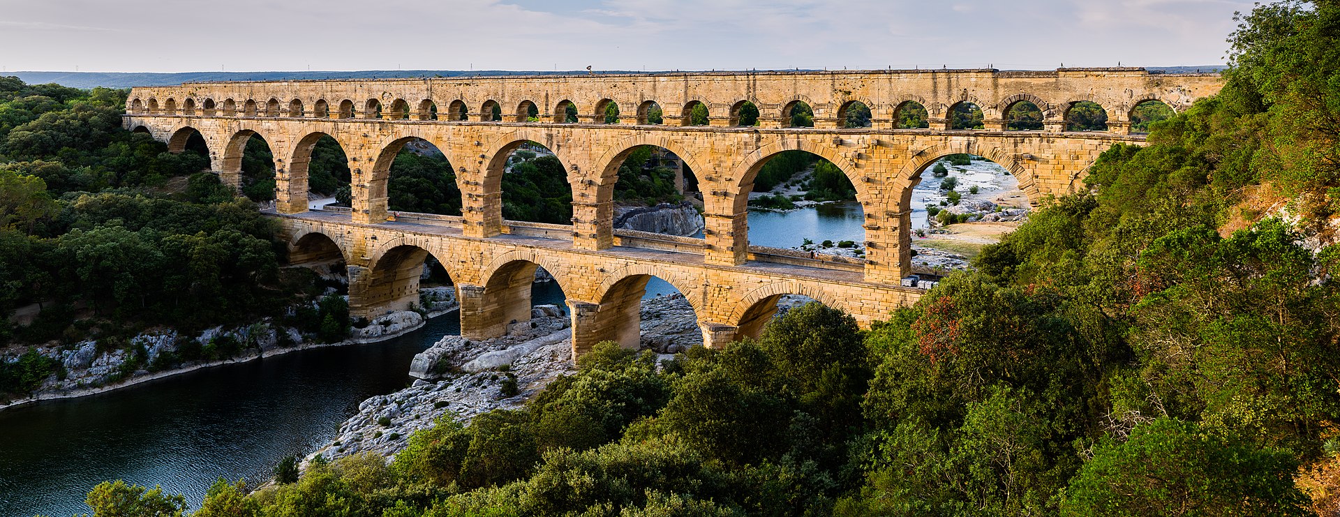
The Pont du Gard is an ancient Roman three-tiered aqueduct bridge that carried water across the Gardon river to Nemausus (Nîmes). It stands as a long, arched limestone structure spanning the river and surrounding garrigue and has been preserved and restored into the present day.
First raised
AD 50
Its prime
AD 50
Today
Restored
As it stood in AD 50
What Pont du Gard looked like in its prime.
A long, three-tiered stone bridge of pale reddish shelly limestone with rows of recessed arches rising to about 48.8 m above the river and stretching roughly 274 m. The lowest tier has large wide arches, the middle tier similar but smaller, and the top tier carries the narrow water conduit; the upper levels curve slightly upstream. Ashlar blocks are precisely cut and fitted without visible mortar, some bearing builders' marks. The river flows beneath among limestone banks and trees.
Its story
The story of Pont du Gard.
Water from the Fontaine d'Eure to Nemausus, Mid-1st Century AD
The bridge is the monumental stretch of an aqueduct that carried water from the springs of the Fontaine d'Eure, at the foot of Uzès, to the castellum divisorum at Nemausus (Nîmes). The straight-line distance is about 20 km, but the channel winds some 50 km round the eastern end of the Garrigues de Nîmes, tunnelling through the hills having been impractical. An estimated 40,000 cubic metres of water a day reached the city. Varying the gradient along the route allowed the engineers to hold the bridge to 48.77 m above the river, six metres lower than a uniform fall would have demanded.
Construction was long credited to Augustus's son-in-law Agrippa around 19 BC, a view Émile Espérandieu tied in 1926 to Agrippa's visit to Narbonensis in 19 BC. Excavation has since shown that the builders had to bypass tunnels of Augustan date, and coins found in the outflow at Nîmes are no older than the reign of Claudius (41–54 AD); on that basis a team led by Guilhem Fabre argued for completion around the middle of the 1st century. The aqueduct is thought to have taken about fifteen years and employed between 800 and 1,000 men, the bridge itself perhaps three to five.
Dry Stone from the Estel Quarry
Most of the stone is a coarse shelly limestone known locally as pierre de Vers, cut from the Estel quarry about 700 m downstream. The blocks (some of six tons, 50,400 tons in all) were dressed to fit by friction and gravity, and the bridge was raised almost entirely dry, only the topmost part at conduit level being bonded with mortar. Builders numbered them and marked their places (fronte dextra, fronte sinistra), and left blocks protruding to carry the scaffolding; each great arch was built as independent rings side by side, so the structure could absorb settlement.
Silted, Abandoned and Quarried, 4th–12th Centuries
Maintenance failed from the 4th century onwards, and lime deposits closed in until they filled two-thirds and in places three-quarters of the conduit. Analysis of those deposits once suggested water reached Nîmes as late as the 9th century; later investigation places the end of use at about the beginning of the 6th. The dry aqueduct then served as a quarry: its small limestone blocks went into castle walls, Romanesque churches, houses and cemeteries. Around the 12th century twelve arches of the top tier were pulled down for their stone.
Toll Bridge, Artillery Damage and Pitot's Road Bridge, 13th–18th Centuries
In the 13th century the king granted the seigneurs of Uzès the right to levy tolls on those crossing; the right passed later to the bishops of Uzès, who in return were to keep the bridge in repair. The piers of the second tier were cut back to widen that crossing, dated to the Middle Ages in some accounts and in others to the 1620s, when Henri, Duke of Rohan had one side of the second row of arches cut away to a depth of about a third of its thickness to move artillery across during the wars in which he led the Huguenots.
In 1647 the bishop of Nîmes warned the Estates of Languedoc that the bridge was in danger of ruin. The intendant, Nicolas de Lamoignon de Basville, ordered an estimate in 1696, and works lasting until 1704 partly filled the notches and added corbelled passages around each pier. In 1743–47 the engineer Henri Pitot set a road bridge against the arches of the lowest tier; the marble plaque the Estates fixed to record the work was destroyed in 1793.
Questel, Laisné and the Grand Site, 1835–2004
Prosper Mérimée saw the bridge in 1835 at risk of collapse from erosion and lost stonework. Charles-Auguste Questel restored it in 1842–46, cutting a stair inside the last pier to reach the conduit. Napoleon III visited in 1850 and approved plans by the architect Charles Laisné; the work begun in 1855 was the heaviest the bridge has had, replacing eroded stone, infilling piers with concrete and improving drainage by separating bridge from aqueduct. The Pont du Gard was classified as a historical monument on the list of 1840 and inscribed as a UNESCO World Heritage Site in 1985.
Vehicles were still crossing Pitot's bridge in the 1990s. In 1996 the General Council of the Gard began a four-year scheme backed by the French state, UNESCO and the European Union; the area was pedestrianised, a visitor centre designed by Jean-Paul Viguier opened in 2000, and access to the conduit was limited to guided tours. The site was named a Grand Site de France in 2004 and is run by a public body for cultural cooperation; 1.4 million visitors were reported in 2001. The lower tier was submerged by a flood in 1958, and in September 2002 the Gardon rose to three-quarters of the lowest arches, damaging installations nearby but not the bridge.
Step inside
9 places to explore in AD 50.
The record describes 9 distinct spots at Pont du Gard, including 1 interior: inside the water conduit (specus). Create your own photoreal reconstruction and explore every one, more scenes means more photos, more angles and more of the immersive experience.
Build Your Own Castle
Recreate Pont du Gard with AI to explore it.
The artist rebuilds it as it stood in AD 50, a photoreal reconstruction that belongs to you alone. Pay with coins, no subscription needed.
Recreate Ancient site to Explore →Nearby