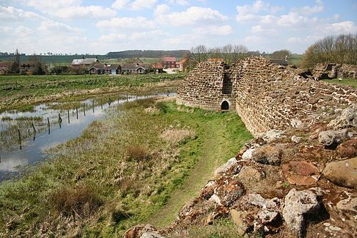
England · Partial ruin
Cadbury Castle
Cadbury Castle is a large Bronze- and Iron-Age hillfort on the limestone summit of Cadbury Hill in Somerset, England. The site consists of a 7.28-hectare plateau encircled by multiple earthen ramparts and ditches and shows long sequences of occupation from the Neolithic through post-Roman (sub-Roman) periods. It is a scheduled monument long associated in local tradition with the Arthurian court of Camelot.
Its prime
550
Today
Partial ruin
As it stood in 550
What Cadbury Castle looked like in its prime.
A broad, grassy limestone summit plateau ringed by multiple concentric earthen banks and deep ditches, with timber palisades and wooden gateways set on the inner crest. The hilltop is dotted with clusters of low roundhouses and several rectangular timber-framed buildings with thatched roofs, including a long timber Great Hall. Tracks and penning areas cut across the turf; scattered postholes and terrace lynchets mark past cultivation on the slopes. The surrounding lowlands are open pasture and hedgerows.
Its story
The story of Cadbury Castle.
From Neolithic Farmers to Iron Age Fort
Cadbury Castle is not a medieval castle at all but a Bronze and Iron Age hillfort, crowning a limestone hill on the southern edge of the Somerset Levels, five miles north-east of Yeovil. People were living and farming on the summit long before anyone fortified it: pits and post holes with Neolithic pottery and flints mark a small unenclosed settlement, and bones from the site have been radiocarbon dated to 3500–3300 BC. Late Bronze Age ovens followed, and excavation on the lower slopes turned up the first Bronze Age shield ever recovered from an excavation in north-west Europe, a Yetholm-type shield of about 1350–1150 BC, with a roughly contemporary metal-working building found two kilometres to the south-east.
Around 300 BC a stone enclosure with timber revetting was built and ploughing on the hilltop ceased. Rectangular post-built structures gave way to roundhouses, and large ramparts with elaborate timber defences were raised and refortified over the following centuries. In the first century BC further lines of bank and ditch turned the hill into a true fort, the site now covers an 18-acre summit plateau ringed by an inner bank three-quarters of a mile long, with four ramparts on the north-west and south sides. Finds of metalworking and a possible sequence of small rectangular temples or shrines point to permanent, town-like occupation.
The Roman Assault on the South-West Gate
There is evidence that the fort was taken by violence around AD 43, the time of the Roman invasion. Excavations at the south-west gate in 1968 and 1969 revealed one or more severe episodes of destruction, with weaponry and burning; the resistance has been attributed to the Durotriges and Dobunni fighting the Second Augusta Legion under Vespasian's command. The date of the destruction is argued over: Leslie Alcock, who dug the site, placed it around AD 70, while Richard Tabor ties it to the initial invasion of AD 43 or 44. What is not in doubt is what followed: a Roman army barracks was built on the hilltop and the defences were slighted later in the first century. The hill saw significant activity again in the late third and fourth centuries, which may have included a Romano-British temple.
The Great Hall of a Brythonic Ruler, c. 470–580
After the Roman administration withdrew, the hilltop came back to life. From around 470 until some time after 580 the innermost Iron Age defences were refortified, creating a defended site double the size of any other known fort of the period. Alcock's excavations revealed a substantial Great Hall, twenty metres by ten, and shards of pottery imported from the eastern Mediterranean, evidence of trade links reaching across Europe. It seems probable that this was the chief fort of a major Brythonic ruler, holding his family, warband, servants and horses.
It is this phase that fed the site's most famous claim. Local tradition, first written down by John Leland in 1542, holds that Cadbury Castle was King Arthur's Camelot. The writer Geoffrey Ashe argued that this extensive site was the base of a historical Arthur, though his view has not been widely accepted by students of the period. If Arthur was indeed conceived at Tintagel, as tradition asserts, he may have been a prince of Dumnonia using Cadbury as a stronghold on his eastern frontier.
Mint, Domesday and the Archaeologists
The hill had two late footnotes as a working site. Between 1010 and 1020 it was reoccupied as a temporary Saxon mint, standing in for the mint at Ilchester, and according to the Domesday Book it appears to have been part of the feudal barony of North Cadbury, held in 1086 by Turstin FitzRolf. Some small-scale fortification may have followed in the 13th century, but the hilltop's fighting days were over.
Its modern history belongs to the diggers. The local clergyman James Bennett excavated in 1890 and Harold St George Gray in 1913, before Alcock's major campaign of 1966–1970 established the long sequence of occupation; many of his finds are displayed in the Museum of Somerset in Taunton. Since 1992 the South Cadbury Environs Project has carried the work outwards, surveying the landscape up to eight kilometres from the fort. The site has been a scheduled monument since 1922, and its rampart sequence is reckoned one of the deepest and most complex Iron Age stratigraphies ever excavated in southern Britain.
Step inside
9 places to explore in 550.
The record describes 9 distinct spots at Cadbury Castle, including 3 interiors: great hall interior, cluster of roundhouses, sequence of small rectangular shrine buildings. Create your own photoreal reconstruction and explore every one, more scenes means more rooms, more angles, and more of the place to stand in.
Build Your Own Castle
Recreate Cadbury Castle with AI to explore it.
The artist rebuilds it as it stood in 550, a photoreal reconstruction that belongs to you alone. Pay with coins, no subscription needed.
Recreate this castle →Defend this castle →Nearby