Historic Cities · Wales
Caernarfon through the ages
Caernarfon is a royal town, community and port, in Gwynedd, Wales. The community has a population of 9,852. It lies along the A4871 road, on the eastern shore of the Menai Strait, opposite the island of Anglesey. Bangor is 9 miles (14 km) to the north-east, Porthmadog is 20 miles (32 km) southeast and Holyhead is 29 miles (47 km) northwest, via the Britannia Bridge.

Caernarfon in AD 120
Roman Segontium
This is Segontium at the height of Roman consolidation in north Wales: an auxiliary fort planted above the mouth of the Afon Seiont, watching the Menai channel and the island of Môn (Anglesey). The walk follows the fort ramparts into the adjacent vicus, past workshops, granaries and the sunken Mithraeum to landing places where ships beach on the tidal shore, with the peaks of Eryri behind.
Low turf and timber ramparts crown a compact Roman fort above the Seiont, with new lengths of dressed stone beginning to edge older earthworks. Timber shops and lean-to stalls line muddy vicus streets; beached coastal traders and small cargo boats crowd the riverbank. Colours favour weathered oak, iron-grey stone, ochres of stored grain and the greens and slate blues of the distant Eryri under changeable coastal light.
The route: 22 streets, squares and views
Afon Seiont Mouth → Menai Strait Channel → Road to Deva → Porta Praetoria → Via Principalis → Porta Decumana → Horrea (Granaries) → Vicus Meridionalis → Timber Workshops → Mithraeum (Temple of Mithras) → …
Step inside, 12 interiors
Gatehouse Guardroom · Auxiliary Barrack Dormitory · Granary Main Store · Granary Drying Loft · Vicus Baker's Hearth · Carpenter's Timber Workshop · Sunken Mithraeum Hall · Stone Funerary Chamber · Riverside Storehouse · Boatwright's Bending Shed · Fort Caldarium · Commandant's Main Hall
Planned from the Wikipedia record: Segontium.
Caernarfon in 1330
Edward I's Caernarfon
This is the new English borough planted beside Edward I’s monumental castle and enclosed by stout town walls completed in the late 13th century. The walk shows the castle’s banded polygonal towers, the King's Gate and Eagle Tower, the tight grid of burgage plots within the walls, and the quay and small harbour on the Menai Strait beneath the garrison's watch.
By 1330 Caernarfon reads as stone: pale grey masonry quarried locally and from Anglesey, thick curtain walls and octagonal or polygonal towers with alternating bands and narrow arrow slits. The castle’s southern façade and the Eagle Tower loom above a compact English borough of timber-framed houses, narrow rectilinear streets and market stalls, while the Menai quay hosts small cargo boats and coasters against a brisk coastal light.
The route: 20 streets, squares and views
Menai Strait Approach → Seiont Quay → Segontium (Roman Fort) → South Town Wall → King's Gate → Eagle Tower → Castle South Façade → Market Place → High Street → Burgess's Hall → …
Step inside, 12 interiors
Riverside Storehouse · Portcullis Guardroom · Upper Guard Chamber · Roof Walk · Great Hall · Merchant Hall · Guild Chamber · Parish Nave · Merchant Ship's Hold · Hall of Butchers · Clothworker's Workshop · Garrison Watch Room
Planned from the Wikipedia record: Caernarfon Castle.
Its story
The story of Caernarfon.
Segontium and the Fort in the Land Opposite Anglesey
The resources of the Menai Strait supported settlement here in prehistory, and the Ordovices, a Celtic people, held the region when Rome arrived. The fort of Segontium was established around AD 80 to subdue them during the Roman conquest of Britain, and the Romans held the region until Roman rule in Britain ended in 382, after which the place became part of the Kingdom of Gwynedd. The parish church of St Peblig's, named for a son of Saint Elen and Magnus Maximus, stands about a kilometre south-east of the later walled town on an early Christian site that was itself built over a Roman temple of Mithras, some 200 metres from the fort; a Roman altar turned up in one of its walls during restoration work in the nineteenth century.
The name is made of three parts (*caer*, a fortress, *yn*, and *Arfon*, meaning opposite Môn), so it reads as the fortress in the land opposite Anglesey. The older settlement at Segontium was Cair Segeint, the fort on the Seiont, and also Cair Custoient, fortress of Constantine, from a belief that it had been the capital of Gwynedd under a supposed son of Elen and Magnus Maximus; both names appear in the Historia Brittonum. The romance Macsen's Dream calls Elen's home Caer Aber Sein, and pre-conquest poets including Hywel ab Owain Gwynedd used Caer Gystennin. A charter granted by Llywelyn the Great to the canons of Penmon in 1221 has Kaerinarfon. In the late eleventh century William the Conqueror ordered a motte-and-bailey castle built here as part of the Norman invasion of Wales; it did not hold, and Wales remained independent until about 1283.
Edward I's Castle and Borough, 1283–1330
Llywelyn ap Gruffudd, ruler of Gwynedd, refused homage to Edward I, and the English conquest of Gwynedd followed. Edward secured it with a chain of castles and walled towns, and work on a new stone castle at Caernarfon seems to have begun as soon as the campaign ended. It was built between 1283 and 1330; its banded stonework and polygonal towers are thought to imitate the walls of Constantinople, and Edward's architect James of St George was possibly aware of the town's legendary associations. The town walls went up between 1283 and 1285, eight towers and two twin-towered gateways in a complete circuit of 800 yards. St Mary's was begun in 1307 as a chapel for the castle and its garrison, built against the town wall with the Bell Tower serving as its vestry.
The town was made a borough by charter of Edward I in 1284, an instrument confirmed repeatedly, and one that made the borough's mayor Constable of the Castle by virtue of his office. The Statute of Rhuddlan in the same year created the English-style county of Caernarfonshire with Caernarfon as its county town and the seat of English government in north Wales. Edward's fourth son, Edward of Caernarfon, was born at the castle in April 1284 and made Prince of Wales in 1301. The tale that the infant was offered to the Welsh on the grounds that he had been born in Wales and could speak no word of English was first recorded in the sixteenth century, and no contemporary evidence supports it.
The Slate Trade and the Municipal Borough, 1828–1888
Caernarfon was at one time an important port, and what it shipped was slate from the quarries of Dyffryn Nantlle. From 1828 the traffic was carried by the Nantlle Railway, a line older than either the Liverpool and Manchester or the Ffestiniog. The town built to match: a corn market in Hole-in-the-Wall Street in 1832, its interior and roof rebuilt later in the century; municipal borough status in 1836 under the Municipal Corporations Act; a county hall and police station on Castle Ditch facing the castle walls, designed in the mid-nineteenth century by the county surveyor John Fisher; barracks completed in 1855; and the small Victorian park at Morfa, laid out in 1888. The population stood at 8,001 in 1841.
Five Stations and the Last Line, 1852–2020
Five passenger stations have served the town. Caernarvon station opened in 1852 as the western terminus of the Bangor and Carnarvon Railway, tying the town to the coast and the national network. Carnarvon Castle station opened in 1856 as the northern terminus of the narrow-gauge Nantlle Railway and closed in 1865 when the standard-gauge Carnarvonshire Railway took over most of its trackbed from the south. Pant, to the south, opened in 1867, and Carnarvon (Morfa), on the line from Llanberis, in 1869, so that for a short period three terminating stations sat on the town's edges. Records are contradictory as to whether they were joined in 1870 or 1871 by a line driven through the town; the tunnel it used survives, converted for road traffic in 1995. Pant and Morfa closed on the through route's opening, and by 1871 the London and North Western Railway had absorbed all the lines.
The services to Llanberis and south to Afon Wen closed progressively from the 1930s and the tracks were lifted in the mid-1960s. The station itself lasted until 1970, Bangor to Caernarvon being among the last passenger services closed under the Beeching cuts; a supermarket occupies the site. In November 2020 the Welsh Government said further consideration should be given to reopening the line. Narrow gauge returned instead: a station opened on the old trackbed in St Helen's Road in 1997 as the northern terminus of the Welsh Highland Railway, and a permanent station begun in February 2017 opened to passengers in the spring of 2019, with heritage steam services running to Porthmadog.
Patagonia, Lloyd George and the First Investiture, 1837–1921
Lewis Jones (1837–1904), from the town, was one of the founders of the Welsh settlement in Patagonia. Caernarfon is twinned with Trelew in Chubut Province, Patagonia, and with Landerneau in Brittany.
David Lloyd George was Member of Parliament for the area from 1890 until 1945. In 1911, as MP for the Caernarfon boroughs (a seat that took in towns from Llŷn to Conwy) he agreed to the royal family's proposal that the investiture of the Prince of Wales be held at Caernarfon Castle. The ceremony took place on 13 July, and the future Edward VIII was invested there. Lloyd George's statue by W. Goscombe John was put up in Castle Square in 1921, while he was prime minister.
The Capital Ballot, the 1969 Investiture and the 2019 March, 1955–2019
In 1955 Caernarfon stood for the title of capital of Wales on historical grounds and was heavily beaten in a ballot of Welsh local authorities, taking 11 votes to Cardiff's 136.
The second investiture, that of Charles as Prince of Wales, was held at the castle on 1 July 1969. It passed without incident despite protest and terrorist threat. The bombing campaign that accompanied it (one device at Abergele, two in Caernarfon and one on Llandudno Pier) was organised by John Jenkins, leader of Mudiad Amddiffyn Cymru, the Welsh Defence Movement. Two of the movement's members, Alwyn Jones and George Taylor, were killed at Abergele when their bomb, intended for the railway line in order to stop the royal train, went off early. Jenkins was arrested after a tip-off and sentenced to ten years' imprisonment. In July 2019 the town hosted a rally and march for Welsh independence organised by All Under One Banner Cymru; the organisers put the turnout at roughly 8,000, and local authorities confirmed at least 5,000.
Royal Town, World Heritage Site and the Cofi Tongue
The spelling took some settling. The town and the county were officially Carnarvon until the borough council resolved on 10 November 1925 to seek a change; the borough became Caernarvon on 14 January 1926 and the county followed on 1 July. The Welsh form Caernarfon was adopted for the community with effect from 2 June 1975, by order of Arfon Borough Council. Royal borough status was granted in 1963; when the borough was abolished in 1974 the successor community was granted the style of royal town instead. District functions passed to Arfon Borough Council and, from 1996, to Gwynedd Council, whose headquarters are in the town.
The castle and town walls were declared part of the World Heritage Site known as the Castles and Town Walls of King Edward in Gwynedd in 1986; UNESCO's assessment groups them with the other royal castles of Gwynedd as the finest examples of late thirteenth- and early fourteenth-century military architecture in Europe. The town has hosted the National Eisteddfod seven times between 1862 and 1979, with unofficial events in 1877 and 1880. Its people are known as Cofis, a word used locally for the town's Welsh dialect as well, which carries a number of words not used elsewhere. Gwynedd has the highest proportion of Welsh speakers in Wales and the greatest concentration of them is in and around Caernarfon; at the 2011 census 85.8 per cent of residents had been born in Wales and 77.0 per cent reported a Welsh-only national identity. The town is now a tourist centre with a working harbour and marina, and the community holds 9,852 people.
From the archive
Caernarfon on paper: the old town as it was mapped.
A period plan or bird's-eye view of the old town, drawn between 1500 and 1850, the streets this page's reconstructions walk. Public domain, with its source named.
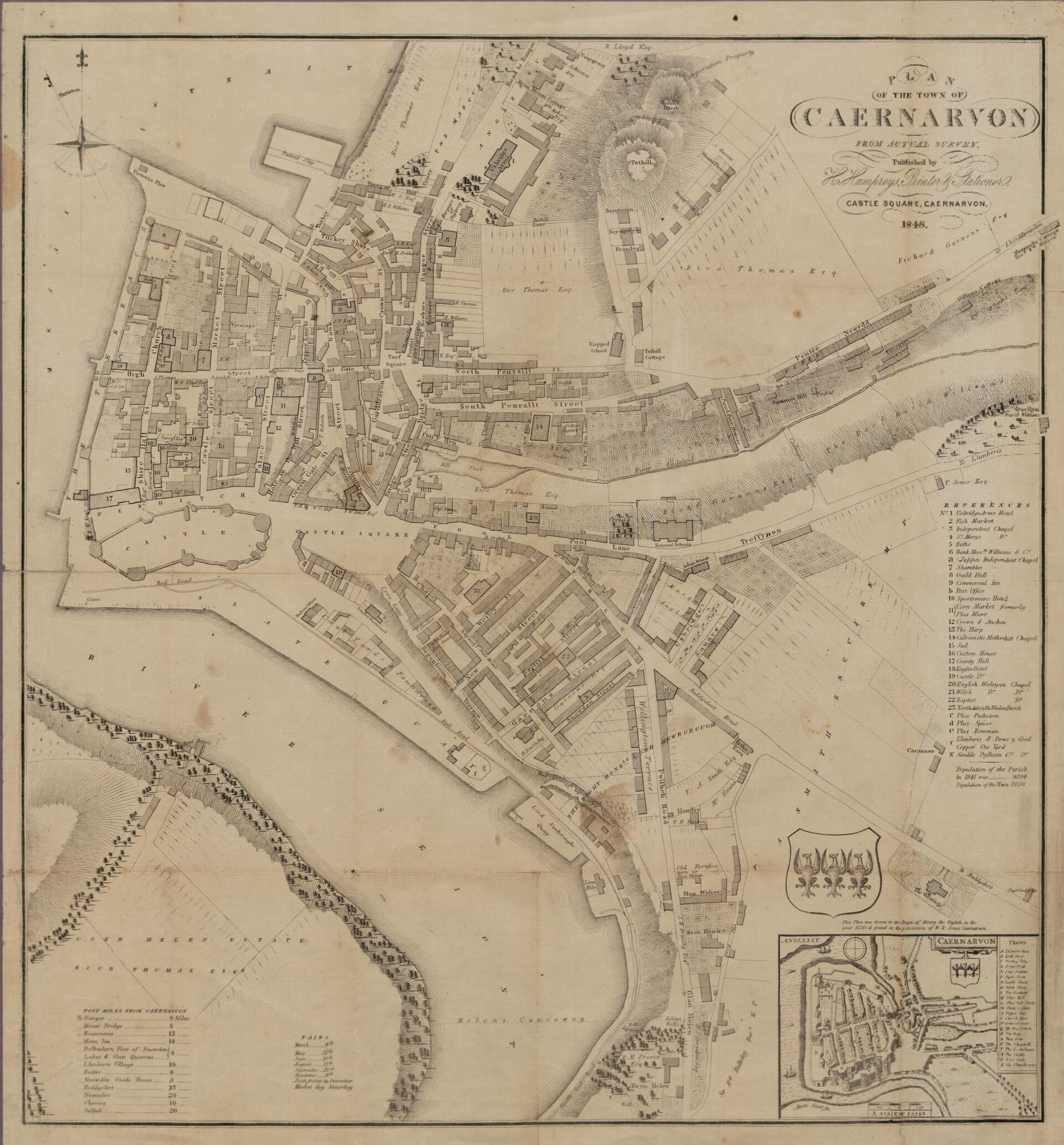
Plan of the town of Caernarvon, from actual survey (published Castle Square, Caernarvon)
Shows Caernarfon Castle and Castle Square, riverside quays and the river, detailed street plan with named High Street and Penrallt, wharves and property plots.
1848 · John Wood (c.1780 - 1847) · Wikimedia Commons
Public domain (plate dated 1848)


Castles of Caernarfon


More cities to explore
 EnglandLiverpoolExplore it in 1850 · 1910
 EnglandChesterExplore it in AD 100 · 1600
 WalesCardiffExplore it in 1300 · 1910
 NetherlandsUtrechtExplore it in 1400 · 1700
Castles of Europe · Landmarks of Europe · create your own reconstruction.