Historic Cities · Netherlands
Utrecht through the ages
Utrecht is the fourth-largest city of the Netherlands, as well as the capital and the most populous city of the province of Utrecht. The municipality of Utrecht is located in the eastern part of the Randstad conurbation, in the very centre of mainland Netherlands, and includes Haarzuilens, Vleuten and De Meern. It has a population of 378,140 as of January 2026.

Utrecht in 1400
Bishops' Utrecht
Utrecht in 1400 is the prince-bishop’s city: a compact clerical capital of brick churches, cloisters and canal wharves that channels the old Rhine through its heart. This walk traces the cathedral cluster around the Dom, the sunken wharves and cellars of the Oudegracht, the collegiate churches set as a cross, and the cloister gardens and markets that sustain the town.
A single stone tower dominates the skyline: the Dom tower rising above a dense field of red-brown brick roofs, stepped gables and narrow church spires. Four collegiate churches cluster around a tight cathedral precinct. Streets are scaled to barges and handcarts, canals cut deep with wharf cellars beneath the houses, and cloister gardens and monastery walls punctuate the urban fabric with sheltered green.
The route: 22 streets, squares and views
Kromme Rijn approach → Catharijnepoort gate → The Weerd landing → Oudegracht wharf → Vismarkt (Fish Market) → Springweg wharf → Domplein → Dom tower base → St Martin's choir → St. Salvator's Church → …
Step inside, 14 interiors
Riverside Warehouse Chamber · Wharf Cellar with Barrels · Fish Hall under Rafters · Nave under Construction · Tower Base Vaulted Chamber · Cathedral Choir at the Hours · Romanesque Canons' Choir · Parish Nave and Pulpit · Guild Chapel under Banners · Enclosed Cloister Garth · Beguine's Courtyard Chamber · Abbey Refectory at Midday · Brothers' Chapter Hall · Weavers' Loom-filled Workshop
Planned from the Wikipedia record: Utrecht.
Utrecht in 1700
Utrecht after the Storm
Utrecht in 1700 is a Dutch Golden Age canal city still marked by the 1674 storm that brought down the cathedral nave and left the Dom tower standing alone across an open square. The walk moves from the low river approaches along the wharf cellars and busy canals through university courts, patrician façades and hidden hofjes to a bastioned vantage above the old city.
Low red and brown brick gables, tile roofs and narrow canals define a compact skyline punctured only by the tall stone ribs of the Dom tower; broad wharf stairways descend from street level to werfkelders where barges are moored. Streets are narrow and shadowed between tall houses with stoops and hall-lanterns, while the university and churchyards provide pale stone accents; the scale is human, the light cool northern daylight with frequent river mists and clear winter sun.
The route: 22 streets, squares and views
Kromme Rijn south bank → Tolsteeg sluice → Oudegracht at Tolsteeg → Wolvenstraat wharves → Vismarkt → Ledig Erf → Twijnstraat → Neude → Springweg → Paushuize → …
Step inside, 12 interiors
Fishmarket stall hall · Hidden hofje courtyard · Blue-and-white kitchen · Paushuize great chamber · Cathedral choir of Saint Martin · Dom tower bell chamber · Janskerk chapter house · Anatomy theatre · Rector's hall · Brewhouse kettle room · Wharf cellar tavern · Geertekerk nave
Planned from the Wikipedia record: Utrecht.
Its story
The story of Utrecht.
Traiectum, a Crossing on the Rhine Limes, c. 50–275
The city's founding date is usually tied to a Roman fortification built here in around 50 CE, one of a series raised after the emperor Claudius decided the empire should expand no further north. The Limes Germanicus defence line ran along what was then the main branch of the Rhine (the course now called the Kromme Rijn, the Crooked Rhine), and each fort was designed to house a cohort of about 500 soldiers. Settlements of artisans, traders and soldiers' families grew up beside them.
The fort was called simply Traiectum, for its position at a possible Rhine crossing. That became the Dutch Trecht, with the U added from Old Dutch uut, downriver, to distinguish it from Maastricht on the Meuse. Around the year 200 the wooden walls were rebuilt in tuff stone, and remnants still lie beneath the buildings around Dom Square. From the middle of the third century Germanic tribes raided the Roman territories repeatedly, and after about 275 the northern border could no longer be held. Utrecht was abandoned, and almost nothing is known of it between 270 and 650.
Willibrordus, and What the Fall of Dorestad Gave Utrecht, 650–850
A church was built inside the walls of the old Roman fort during the seventh-century reign of Dagobert I, and destroyed in the running border conflicts with the Frisians. From the mid-seventh century British, English and Irish missionaries worked to convert those Frisians, and Pope Sergius I appointed their leader, Willibrordus, bishop of the Frisians, a tenure generally taken as the beginning of the Bishopric of Utrecht. In 723 the Frankish leader Charles Martel granted the fortress and the lands around it as the bishops' base.
That made Utrecht one of the most influential seats of the Catholic Church in the Netherlands, sitting on the uneasy northern edge of the Carolingian Empire. It had a commercial rival close by in the trading centre of Dorestad, and it was Dorestad's fall around 850 that left Utrecht among the most important cities in the country. Its standing is measured by the election of the Utrecht-born Adriaan Florenszoon Boeyens as pope in 1522, the last non-Italian pope before John Paul II.
Prince-Bishops, City Rights in 1122, and a Canal Against the Bishop
Under Frankish feudalism the bishops of Utrecht came to hold worldly power as prince-bishops, over territory that covered the modern province, the Nedersticht, and reached north-east as well. The medieval feudal wars fell heavily on them: the prince-bishopric was in almost continuous conflict with the Counts of Holland and the Dukes of Guelders, which took the Veluwe, though large areas of what is now Overijssel stayed in the bishops' hands as the Oversticht.
The city was granted city rights by Henry V at Utrecht on 2 June 1122, and its position on the Rhine made it an important trading centre in the northern Netherlands. When the river's main flow shifted south, the old bed running through the town was progressively canalised and turned into an inner-city harbour, with storage cellars cut into the wharves. Relations with the bishop, who controlled much of the land outside the walls, were not easy. When he dammed the Kromme Rijn at Wijk bij Duurstede to keep his estates from flooding, he threatened the city's shipping, and Utrecht answered by commissioning its own canal, the Vaartse Rijn, running to the Hollandse IJssel at IJsselstein.
Charles V's Garrison and the Demolition of Vredenburg, 1528–1559
In 1528 the bishop lost secular power over both the Nedersticht and the Oversticht, the city included, to Charles V, Holy Roman Emperor, who held the Seventeen Provinces in personal union. The prince-bishopric ended: worldly rule became the lordship of Utrecht, religious authority stayed with the bishop, and Charles V took the right to appoint new ones. In 1559 the bishopric was raised to an archbishopric, the religious centre of the northern ecclesiastical province.
The city did not accept the demotion quietly. Charles V struggled to hold citizens who had spent generations prising independence from their bishops and had no intention of ceding it to a new lord, and the heavily fortified castle Vredenburg was built to quarter a garrison whose main task was keeping Utrecht in hand. It stood less than fifty years before an uprising in the opening stages of the Dutch Revolt pulled it down.
The Union of 1579: a Republic Founded Here, a City Left Behind
In 1579 the seven northern provinces signed the Union of Utrecht in the city, agreeing to combine against Spanish rule; the treaty is taken as the beginning of the Dutch Republic. The following year the new and largely Protestant state abolished the bishoprics, Utrecht's archbishopric among them. The stadtholders disliked the independent course of the Utrecht bourgeoisie and brought the city under much tighter republican control, shifting power towards the dominant province of Holland, the start of a long stagnation in the city's trade and development. Utrecht stayed an atypical place in the new republic, around 40 per cent Catholic in the mid-seventeenth century and more so among its elite, which included rural nobility and gentry keeping town houses there.
The fortified city fell briefly to the French invasion of 1672, the Rampjaar, which was halted just to its west at the Old Hollandic Waterline. Two years after the French withdrew, a catastrophic derecho struck the centre in 1674, and the fifteenth-century decision to suspend work before the cathedral's flying buttresses were finished proved its undoing: the central section of St Martin's collapsed, opening the gap between tower and choir that is Dom Square today. In 1713 the city hosted the negotiations that produced the Treaty of Utrecht, settling the War of the Spanish Succession, and from 1723 it became the centre of the non-Roman Old Catholic Churches.
Ramparts Down, Rails In, 1843–1945
By the early nineteenth century Utrecht's role as a fortified town was obsolete (the defences of the Nieuwe Hollandse Waterlinie had been moved east of it), and the walls came down to let the city expand, though the moats were kept and shaped into the Zocher plantsoen. A railway to Amsterdam opened in 1843, and Utrecht became by degrees the main hub of the Dutch rail network. When the government allowed Rome to reinstate the bishopric in 1853 it was once again the centre of Dutch Catholicism, and new districts spread east and west of the medieval core from the 1880s onward.
German forces held the city through the Second World War until the general German surrender of the Netherlands on 5 May 1945; the British and Canadian troops who had surrounded Utrecht entered it two days later, on 7 May. A municipality of the Netherlands since 1812, it is now the capital and most populous city of the province of Utrecht and the fourth-largest in the country, with a population of 378,140 as of January 2026.
From the archive
Utrecht on paper: the old town as it was mapped.
A period plan or bird's-eye view of the old town, drawn between 1500 and 1850, the streets this page's reconstructions walk. Public domain, with its source named.
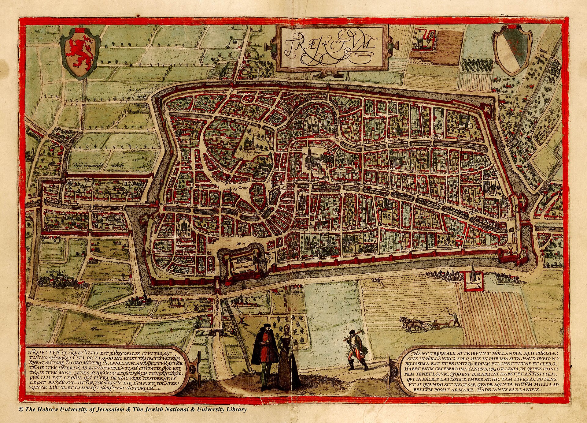
Bird's-eye view of Utrecht (Traiectum), from Braun & Hogenberg's Civitates Orbis Terrarum
Shows Utrecht’s medieval walls and moat, city gates, winding street plan, canals and the prominent Dom cathedral tower.
1572 · Georg Braun & Frans Hogenberg; Gravure:Melchiesedech van Hoorn (1569) · Wikimedia Commons
Public domain (plate dated 1572)
More cities to explore
 NetherlandsAmsterdamExplore it in 1550 · 1660 · 1890
 NetherlandsRotterdamExplore it in 1690 · 1935
 NetherlandsSaeftingheExplore it in 1570
 NetherlandsMaastrichtExplore it in 1770
Castles of Europe · Landmarks of Europe · create your own reconstruction.