Historic Cities · Netherlands
Maastricht through the ages
Maastricht is a city and a municipality in the southeastern Netherlands. It is the capital and largest city of the province of Limburg. Maastricht is located on both sides of the Meuse, at the point where the river is joined by the Jeker. Mount Saint Peter (Sint-Pietersberg) is largely situated within the city's municipal borders.

Maastricht in 1770
Garrison on the Meuse
Maastricht in 1770 is a prosperous, double‑ruled fortress city where church bells compete with drum calls and soldiers are as visible as merchants. The walk will move from the river approach and the old stone bridge through the market and ecclesiastical heart to the ramparts, quays and glacis where barges, mills and garrison life shape the streets.
The skyline is low and church‑punctuated: squat Romanesque stone churches and the red brick tower of Sint Jans rise above rows of steeply pitched tiled roofs and warm marl and brick façades. Heavy stone arches of the Sint Servaasbrug span the slow Meuse, whose quays bear wooden cranes and grain barges. Thick bastions, earthen glacis and a visible medieval wall frame narrow cobbled streets, watermills on the Jeker and meadow approaches beyond the outworks.
The route: 16 streets, squares and views
Maas Bend at Itteren → Sint Servaasbrug Arches → Maas Quay and Crane → Stokstraat → Vrijthof Square → Saint Servatius Basilica Exterior → Sint Jans Red Tower → Onze‑Lieve‑Vrouweplein → Markt and the Stadhuis → Jekerkwartier and Watermills → …
Step inside, 9 interiors
Bargeman's Cabin on the Maas · Treasure Chamber of Servatius · Romanesque Nave of Servatius · Bell Chamber of Sint Jans · Romanesque Choir of Our Lady · Grand Council Chamber · Miller's Wheelhouse Beneath Jeker · Helpoort Gatehouse Guardroom · Casemate Vaulted Gallery
Planned from the Wikipedia record: Maastricht.
Its story
The story of Maastricht.
Trajectum: the Crossing, the Bishopric and the Pilgrimage
The city exists because of a shallow place in the Meuse. Celts were living at the crossing around 500 BC, where the river was low enough to wade, and the clay pit at Belvédère west of the city has yielded Neanderthal remains and traces of habitation around 250,000 years old, the oldest archaeological finds in the Netherlands. Around 10 BC the Romans laid the military road from Cologne to Tongeren, later called the Via Belgica, which crossed the Meuse here; a bridge was built in the first century AD, in the reign of Augustus, and a settlement grew at its foot. It is not known when the Romans arrived, or whether they founded the place at all. Roman Maastricht was small. It was destroyed by invading Germanic tribes around 270, and to protect the bridge a castrum was built on the left bank in 333 or soon after.
By tradition the Armenian-born Saint Servatius, bishop of Tongeren, died at Maastricht in 384 and was buried along the Roman road outside the castrum, in the cemetery on what is now the Vrijthof. Gregory of Tours records that it was bishop Monulph who around 570 raised the first stone church over the grave, the ancestor of the present Basilica of Saint Servatius. In the eighth century, or by some accounts the ninth, the see was lost to nearby Liège.
The town did not decline with the bishopric. A toll was collected here in Merovingian times and coins struck in Maastricht have been found across Europe; in the early Middle Ages it was a centre of river trade and manufacturing, and formed with Aachen and Liège part of what is regarded as the Carolingian heartland. Vikings plundered it in 881. In the tenth century it was briefly the capital of the duchy of Lower Lorraine, whose last duke died in captivity and was reburied in the church of Saint Servatius around the year 1000. From about that date the two chapters of the town, Saint Servatius and Our Lady, began rival building campaigns, and with them came a cultural flowering: Mosan silversmithing and Romanesque carving of the first rank, and Hendrik van Veldeke's life of Saint Servatius, among the earliest works of Dutch literature. Both churches accumulated relics, and the pilgrimage held every seventh year drew as many as 100,000 people.
Two Lords: the Alde Caerte and the Walled Town, 1204-1500
Maastricht never received city rights by charter; they accumulated gradually over centuries. What it received instead, in 1204, was a second master: the emperor granted the town in fief to the duke of Brabant, so that from then on it answered to the duke and to the prince-bishop of Liège together. That joint sovereignty was set down in a constitutional treaty of 1284, the Alde Caerte, supplemented after disputes over its meaning by the Doghter Caerte of 1356, and the arrangement lasted until the French Revolution. In 1229 Duke Henry I of Brabant gave leave to replace the earthen rampart with a stone wall; a second wall in the fourteenth century quadrupled the area enclosed.
In 1275 the old Roman bridge collapsed under the weight of a procession, reportedly killing four hundred people. A replacement slightly to the north, paid for by church indulgences, was begun in 1281 and survives today as the Sint Servaasbrug. The late medieval economy rested on tanning and cloth-making, in leather and wool, and monasteries settled in the town in numbers from the thirteenth century. Around 1400 Brabant, and so part of Maastricht, passed to the duke of Burgundy and his successors. Economic decline set in gradually over the same period.
Heresy, Fury and Siege: the Garrison Town, 1500-1748
In the sixteenth century Maastricht had fifteen to twenty thousand inhabitants and was among the larger towns of the Netherlands, and around 1500 it enjoyed a modest revival. Religious repression bore down hard on it. In 1535 fifteen Anabaptists were burned at the stake on the Vrijthof for heresy. In the iconoclasm of 1566 images and church furniture were destroyed here as elsewhere. The revival stopped and poverty spread. In the Spanish Fury of 1576 an estimated 1,250 to 1,500 citizens were killed. In 1579 Alexander Farnese, later Duke of Parma, took the city by siege and sacked it, and the Counter-Reformation followed; for over fifty years the Spanish crown held the place in the joint government that the dukes of Brabant had held before.
Because the crossing was strategically valuable, the sixteenth and seventeenth centuries covered the town in fortifications, and the Spanish and then Dutch garrisons became a significant part of its economy. In 1632 Prince Frederick Henry of Orange took the city and the Dutch States General replaced the Spanish crown in the condominium; the peace terms gave Reformed and Catholics the same rights and freedom of worship, and a Spanish attempt to retake the place in 1634 failed. In June 1673, during the Franco-Dutch War, Louis XIV besieged Maastricht because French supply lines were threatened, and it was here that the engineer Vauban worked out the systematic method of attacking a fortress that remained the standard method until the twentieth century. On 25 June 1673, preparing to storm the city, captain-lieutenant Charles de Batz de Castelmore, the comte d'Artagnan, was killed by a musket shot outside the Tongerse Poort. French troops held Maastricht from 1673 to 1678 and took it again in 1748, during the War of the Austrian Succession; under both occupations the city's Protestants lost their equal rights. The fortifications were repaired and enlarged after each siege, and between them the town was a sleepy provincial place enlivened chiefly by its garrison.
Annexed to France, Awarded to the Netherlands, 1793-1839
The French revolutionary army failed to take the fortress in 1793; on 4 November 1794 the commander Kléber succeeded. Under the Treaty of The Hague of 16 May 1795 Maastricht was annexed to the French Republic, ending the centuries-old rule of two lords for good, and became capital of the department of Meuse-Inférieure, a rank it held until 1814-15. The French inheritance was, on balance, not a good one: churches, chapters and monasteries were dissolved, their valuable contents sold or destroyed, libraries, archives and treasuries plundered, and centuries-old institutions for the care of the sick, the poor and the old abolished.
On 1 August 1814 Maastricht became the capital of the new province of Limburg, which from 1815 lay within the United Kingdom of the Netherlands. When the southern provinces seceded in 1830, most of the inhabitants of the town and the country around it sided with the Belgian revolutionaries, but the Dutch garrison under its commander Dibbets held for King William I and the city stayed under Dutch rule. Arbitration by the Great Powers allocated Maastricht to the Netherlands in 1831; neither the Dutch nor the Belgians accepted the ruling, and it was not put into effect until the Treaty of London in 1839.
Regout's Potteries and the Fortress Lifted, 1826-1920
It was during those years of isolation that Maastricht became an industrial town. In 1834 the young entrepreneur Petrus Laurentius Regout began making glass and crystal on an industrial scale in the Boschstraat, and earthenware two years later; his factories prospered and carried the city with them. The infrastructure came alongside: the Zuid-Willemsvaart canal and the Bassin inner harbour opened in 1826, the Liège-Maastricht canal was dug between 1845 and 1850, the first railway, from Aachen, opened in 1853, and only in 1865 was Maastricht joined to the Dutch railway network. The social cost was heavy. Child mortality was high and average life expectancy low; the city was unhealthy and dirty, with a large pauperised population. Socialism found an early following, though never on the scale of the Walloon industrial basins.
Integration into the Netherlands did not come easily to a city in the far south-east, close to Belgium and Germany, and Maastricht kept a distinctly non-Dutch character through much of the nineteenth century. Its elite spoke Maastrichts and French and had little Dutch, and a French-language newspaper, Le Courrier de la Meuse, appeared here between 1851 and 1892. Education and associational life were organised along confessional lines and largely in Catholic hands well into the twentieth century, and the city was not forced to look northwards until the First World War. Fortress status was lifted in 1867, though the first housing districts outside the medieval wall came well after that; the annexation of several neighbouring municipalities on 1 January 1920 raised the commune from 415 hectares to 3,500.
Occupation and the Jewish Community, 1914-1945
The Netherlands stayed neutral in the First World War, but Maastricht, wedged between Germany and Belgium, took in large numbers of refugees and was strained by them. On the morning of 10 May 1940 the garrison blew up the bridges over the Meuse to slow the German advance; the city was nevertheless taken by surprise in the Battle of Maastricht, and after the capitulation the German occupation began. It lasted four years, four months and four days. In 1943, in the fear that the city would find itself on the front line, an evacuation centre was fitted out inside the Sint-Pietersberg. Allied air raids killed many and destroyed enough housing to leave the city short of it for decades. The three Meuse bridges were destroyed or badly damaged.
The heaviest loss fell on the Jews of Maastricht. Of the 515 members of the Jewish community recorded in 1940, 145 remained in 1945; as elsewhere in the Netherlands, the majority died in Nazi concentration camps. On 13 and 14 September 1944 Maastricht was the first Dutch city liberated by Allied forces, taken by the American Old Hickory Division.
From the Potteries to the Euro, 1945-2025
Population rose sharply after the war and was housed in uniform new districts, at first mostly west of the Meuse; a further annexation on 1 July 1970 brought the number of inhabitants to 112,500. From the 1960s the city secularised and its confessional pillars broke down, and the Roman Catholic Church lost much of its influence. The old industries went the other way: the potteries declined through the second half of the century and the economy shifted to services. The glassworks that had been Kristalunie Maastricht, latterly O-I Manufacturing, closed in October 2025.
The university that opened in the 1970s as the Rijksuniversiteit Limburg, renamed Maastricht University in 1996, brought a more varied and more international population with it, and European and international bodies established themselves in the city from the 1980s. European Councils met at Maastricht in 1981 and 1991, and the second produced, a year later, the Maastricht Treaty that created the European Union and the euro. The European Fine Art Fair has been held here annually since 1988. In the early 2000s the city campaigned against drug dealing, aimed at foreign buyers exploiting liberal Dutch law and causing trouble in the centre.
Maastricht is the capital and largest city of the province of Limburg, on both banks of the Meuse where the Jeker joins it, hard against the Belgian border and part of the Meuse-Rhine Euroregion of about 3.9 million people that takes in Aachen, Liège and Hasselt. It holds 1,677 national heritage buildings, the second largest number in the Netherlands after Amsterdam.
From the archive
Maastricht on paper: the old town as it was mapped.
A period plan or bird's-eye view of the old town, drawn between 1500 and 1850, the streets this page's reconstructions walk. Public domain, with its source named.
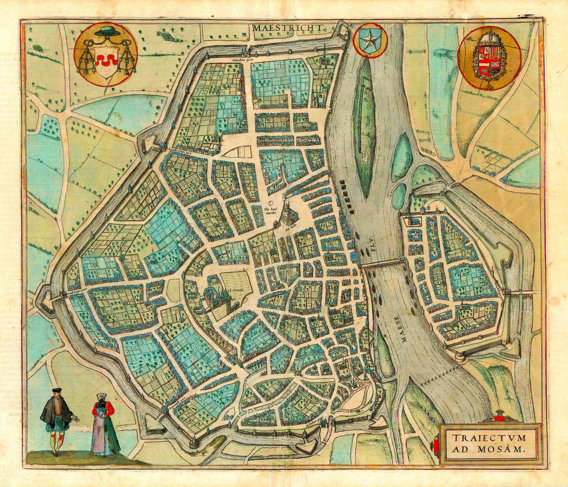
Plan of Maastricht (Traiectum ad Mosam), from Braun & Hogenberg's Civitates Orbis Terrarum
Shows Maastricht's walled medieval town with streets, gates and churches, the River Maas, bridges and a fortified island.
1575 · Georg Braun & Frans Hogenberg. · Wikimedia Commons
Public domain (plate dated 1575)
Castles of Maastricht

More cities to explore
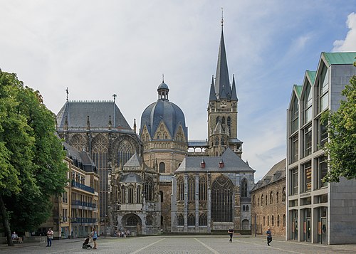 GermanyAachenExplore it in AD 800 · 1500
 BelgiumLeuvenExplore it in 1470
 NetherlandsAmsterdamExplore it in 1550 · 1660 · 1890
 NetherlandsUtrechtExplore it in 1400 · 1700
Castles of Europe · Landmarks of Europe · create your own reconstruction.