Historic Cities · Belgium
Leuven through the ages
Leuven, also called Louvain, is the capital and largest city of the province of Flemish Brabant in the Flemish Region of Belgium. A Dutch-speaking municipality, it is located about 25 kilometres east of Brussels. The municipality itself comprises the sub-municipalities of Heverlee, Kessel-Lo, Leuven proper, Wilsele, and Wijgmaal and parts of Haasrode and Korbeek-Lo.

Leuven in 1470
Gothic Leuven
A prosperous Brabant cloth town reborn after 1425 as a university city, Louvain in 1470 shows its new civic pride: the lace-like pinnacles of the recently topped Town Hall and the soaring choir of Sint-Pietersberg. This walk moves from the city walls and gates into the collegiate streets and the Grote Markt, then follows the Dyle past mills and breweries to the brick lanes of the Grand Béguinage and the abbey slopes beyond.
In 1470 Louvain's silhouette is dominated by the stone filigree of the new Town Hall and the mass of Sint-Pieterskerk, their pinnacles and spires rising above a sea of steep red-tile roofs and stepped-gable façades. The Grote Markt is edged with narrow guild-front houses of brick and timber; the long timber-and-stone cloth hall stands near the square. Along the Dijle low brick breweries and wooden millraces crowd the river, while a stout second ring of walls and gate towers encloses the town.
The route: 16 streets, squares and views
Fields outside Naamsepoort → Naamsepoort → Naamsestraat → Colleges, Naamsestraat → Lakenhal (Cloth Hall) → Grote Markt → Stadhuis (Town Hall) façade → Sint-Pieterskerk → Guild houses, Grote Markt → Wolstraat (Wool Street) → …
Step inside, 8 interiors
Disputation Hall · University Schoolroom · Aldermen's Chamber · Choir with the Last Supper · Drapers' Great Hall · Woolworker's Workshop · Cooling Loft · Béguine's Parlour
Planned from the Wikipedia record: Leuven.
Its story
The story of Leuven.
Luuanium on the Dyle: the Name and the First Mentions
The name is old and the record of it is untidy. The Annales Vedastini enter Luuanium under the year 884, and Regino of Prüm, describing the events of 884 and 886 in his world chronicle, writes of the place called Lovon; other accounts date the first mention to 891, the year a Viking army was defeated here by the Frankish king Arnulf of Carinthia in the battle that carries the town's name. The modern spelling only settled in from the sixteenth century.
What the name means has been argued over for as long. One line traces it to Lubaniom, formed from a personal name Lubanios, "the beloved", from the Indo-European root leubh-, "to love"; Maurits Gysseling proposed a Proto-Germanic lubanja- with the same sense. Edward Van Even, writing in the nineteenth century, preferred two Germanic elements, lo, "leafy wood", and ven, "fen", a marsh in the wood, which at least described the ground the town was built on. Older explanations, including a foundation by a legendary Scottish prince called Lupus, are no longer entertained.
The town's red-white-red arms are traditionally explained by the same Viking battle: so much blood was shed that both banks of the Dyle ran red, with the river white between them. The flag in fact carries the colours of Lower Lotharingia and is heraldically no older than the thirteenth century. Leuven grew up around the castle on the Keizersberg, the hill local legend attached to Julius Caesar.
Cloth and the Duchy of Brabant, 11th–14th Centuries
Sitting on the Dyle beside the stronghold of the Dukes of Brabant, Leuven became the most important centre of trade in the duchy between the eleventh and the fourteenth centuries, and it made its living from cloth. The trade left its mark on the English language: in texts of the late fourteenth and fifteenth centuries ordinary linen cloth was called lewyn, with spellings running through Leuwyn, Levyne, Lewan and Lovanium. The Linen Hall was raised between 1317 and 1345 and still stands, long since turned over to the university.
The town walled itself twice, a Romanesque ring in the twelfth century and a wider fourteenth-century circuit now traced mainly by the line of the ring road. Religious houses clustered around it: Vlierbeek Abbey founded in 1127, the Premonstratensian Park Abbey in 1129, St Gertrude's in 1206, and the Great Beguinage, recognised by UNESCO as a World Heritage Site in 1998. A commandery of the Knights Templar was built on the east flank of the Keizersberg in 1187 and passed to the Knights Hospitaller in 1312 when the order was suppressed.
The University of 1425 and the Collegium Trilingue
The university founded in 1425 made Leuven the oldest university city in the Low Countries, and it is the oldest Catholic university still in existence. Building followed. Saint Peter's Church went up between 1425 and about 1500, finished by Jan Keldermans and Matheus de Layens, and holds the grave of Duke Henry I of Brabant; its tower, meant to reach 169 metres and stopped at fifty, was entered on UNESCO's list of the Belfries of Belgium and France in 1999. The Town Hall was built between 1439 and 1463 by Sulpitius van Vorst, then Jan II Keldermans, and after their deaths by de Layens. Painting flourished with Dirk Bouts, Albrecht Bouts and Jan Rombouts the Elder; Quinten Matsys was born here in 1466 and trained here.
By the turn of the sixteenth century the town had become a major European centre for art and learning, with Erasmus and Hieronymus van Busleyden working in it. Thomas More's Utopia was printed at Dirk Martens' press in Leuven in 1516. The following year Busleyden founded the Collegium Trilingue for the teaching of Latin, Greek and Hebrew and the critical study of classical literature and the Bible; it became the model for the Collège de France. Gemma Frisius laid the foundations of modern triangulation and cartography and taught Gerardus Mercator and John Dee, and the town became a leading centre for precision astronomical instruments, the planetaria and terrestrial and celestial globes of Gaspard van der Heyden and Gualterus Arsenius. Andreas Vesalius completed his medical studies here before leaving for Padua and Basel.
Persecution, Brain Drain and the Cow-Shooters, 1523–1831
The religious persecution of Protestants, and the wider political and religious turmoil that began in the late 1560s, cut deeply into intellectual life. Professors and alumni left the town in numbers; the newly founded University of Leiden was among the institutions that profited from the exodus. What remained still excelled in theology under Johannes Molanus and in classical studies under Justus Lipsius. The Old University eventually held forty colleges and four pedagogies. Pope Adrian VI founded Pope's College for theology students in 1523; St Anthony's College, founded in 1607 on what is now the Pater Damiaanplein, has been a centre of Irish learning on the Continent since the early seventeenth century and houses the Leuven Institute for Ireland in Europe.
Armies came back repeatedly. The town was besieged in 1635, and during a French siege in 1691 its people opened fire one night on shapes moving outside the walls, taking them for enemy soldiers; by morning they had shot a herd of cattle, and Leuven's inhabitants have been called Koeienschieters, cow-shooters, ever since. The castle on the Keizersberg was pulled down in 1782 by order of Emperor Joseph II. The Hospitaller commandery on the same hill was secularised by the French in 1798 and its church and larger buildings demolished. A further Battle of Leuven was fought in 1831.
Artois, Gaslight and the Industrial Town, 1708–1989
In 1708 Sebastien Artois became master brewer at the Den Horn brewery, and in 1717 gave it his name. Brewing became and stayed the town's signature trade (fifty-six breweries were active here at one time), and the Stella Artois brewery on the canal is now the worldwide headquarters of Anheuser-Busch InBev.
The nineteenth century rebuilt the town around it. Dozens of squares were laid out, among them the Volksplaats (today's Ladeuzeplein) and the Statieplein (today's Martelarenplein). Gas lighting arrived in 1835. The Voer was vaulted over, the open channels running down the middle of the streets were removed, narrow streets were widened or destroyed outright, and sewers were laid in quantity. The municipal theatre was built in 1866, the main post office between 1893 and 1895, and the central prison in the same period. A horse tramway opened on 4 April 1874 and an electric network in 1912; the last tram line in Leuven closed on 31 March 1962.
Until the 1980s the town also lived by metalworking. The Ateliers de la Dyle, on the ground the Stella Artois brewery now occupies, built trams and trains and, in the 1960s, caravans; other works included the Delin bicycle factory, the Wanet shoe factory and the Fabota and Hottat textile mills. A Philips plant stood on the site now called the Philipssite from 1929 until 1989.
The Library Burned Twice: Leuven in Both World Wars
On Germany's entry into the First World War the town was heavily damaged by rampaging soldiers. About 300 civilians were killed. The university library was destroyed on 25 August 1914 with petrol and incendiary pastilles, and roughly 230,000 volumes were lost, among them Gothic and Renaissance manuscripts, a collection of 750 medieval manuscripts and more than 1,000 incunabula printed before 1501. The burning was carried out as a reprisal, legal at the time under international law, on the German allegation that Belgian civilians had taken part in the fighting and killed German troops. The atrocities and the destruction of the collection caused worldwide outrage. The old library building was rebuilt and much of the collection replaced, and a new Central Library, designed by the American architect Whitney Warren and given by the American people, was opened on the Ladeuzeplein on 4 July 1928.
In May 1940 Leuven lay on the front line of the British Expeditionary Force and was held by units of the 3rd Division alongside Belgian troops. From 14 to 16 May the German Army Group B attacked with heavy air and artillery support; the British pulled back to the River Senne on the night of 16 May and the town was occupied the following day. Warren's library was set alight by shelling on 16 May and nearly a million books were lost. In September 1942 the Stalag 304 prisoner-of-war camp was moved from Zeithain to Leuven, holding Soviet, Belgian and Serbian prisoners; it was moved on to Trieste in 1945. Hortense Clews, born in Leuven in 1926, worked in the Resistance and survived a concentration camp; she died in 2006.
Provincial Capital and Research Town, 1977–2030
On 1 January 1977 Leuven was merged with Heverlee, Kessel-Lo and Wilsele, took Wijgmaal from Herent and absorbed parts of Korbeek-Lo and Haasrode, giving the municipality its present 57.51 square kilometres. It is the capital of the province of Flemish Brabant and the seat of its arrondissement, and had 104,009 inhabitants on 1 January 2024. KU Leuven, the largest Dutch-speaking university in the world, counted more than 50,000 students across its three campuses in the city in June 2024.
Much of the economy now runs on what the university produces. The nano-electronics and digital technology centre IMEC and the Flemish Institute for Biotechnology have generated a steady flow of spin-outs in biotechnology, robotics, additive manufacturing and computing, clustered on the Arenberg Science Park and the Haasrode Research Park, and international firms including Siemens, Huawei and Commscope have placed research operations alongside them. The European Commission named Leuven European Capital of Innovation in September 2020, and in September 2025 announced that the city and the East Brabant region would represent Belgium as European Capital of Culture in 2030.
From the archive
Leuven on paper: the old town as it was mapped.
A period plan or bird's-eye view of the old town, drawn between 1500 and 1850, the streets this page's reconstructions walk. Public domain, with its source named.
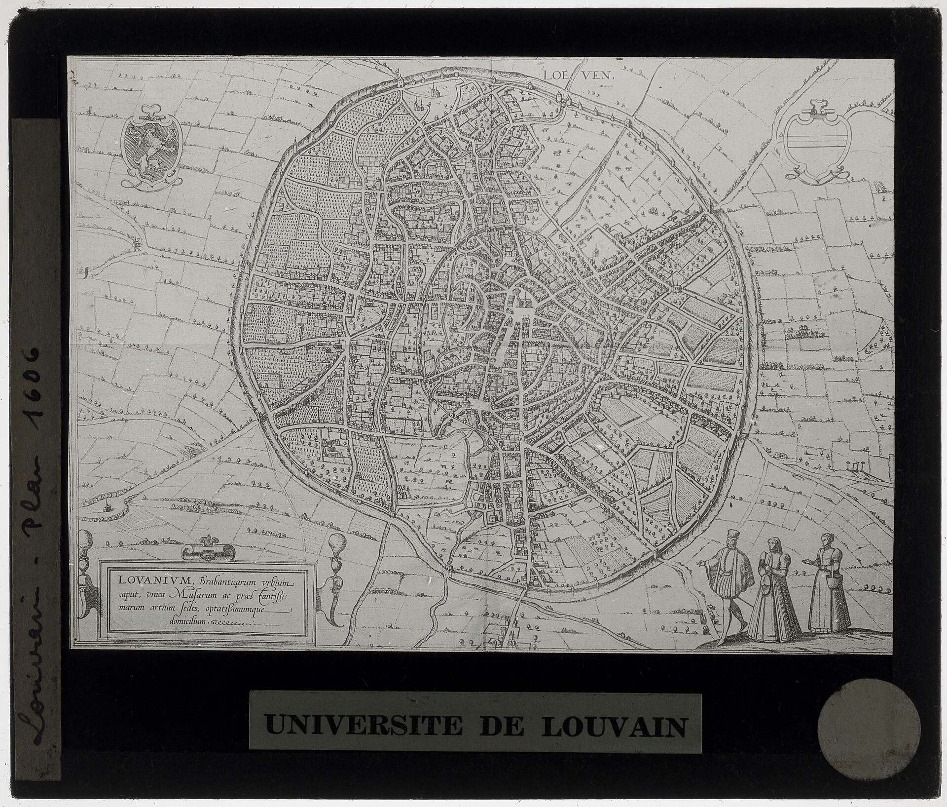
Lovanium: town plan of Leuven (Braun & Hogenberg)
Detailed engraved plan showing the enclosing town wall with gates, the dense medieval street and block pattern, central market/church area and surrounding fields and roads.
1542 · Braun, Georg (German topographer, 1542-1622) (artist) · Wikimedia Commons
Public domain (plate dated 1542)
More cities to explore
 BelgiumBrusselsExplore it in 1560 · 1700 · 1900
 BelgiumAntwerpExplore it in 1560 · 1910
 BelgiumBrugesExplore it in 1300 · 1440 · 1895
 BelgiumGhentExplore it in 1350 · 1913
Castles of Europe · Landmarks of Europe · create your own reconstruction.