Historic Cities · Belgium
Antwerp through the ages
Antwerp is a city and a municipality in the Flemish Region of Belgium. It is the capital and largest city of Antwerp Province, and the third-largest municipality in Belgium by area at 208.22 km2 (80.39 sq mi).

Antwerp in 1560
Golden-age Antwerp
Antwerp in 1560 is the richest, busiest entrepôt in northern Europe, its Scheldt choked with Portuguese, Baltic and Mediterranean merchantmen and its markets loaded with sugar, cloth and spices. The walk follows the river into the old city, past the new Beurs, Plantin’s printing house and the single lace‑like tower of Our Lady's Cathedral towering over guild houses and workshops.
A compact river city of red brick and dark slate roofs, where one enormous lace‑like cathedral tower punctures a skyline otherwise low and tightly packed. Stone wharves and wooden jetties line the busy Scheldt; arcaded stone façades and stepped gables crowd the market squares, narrow crooked lanes and covered canals. Colours are sober (browns, brick reds, lead‑grey and occasional bright merchant banners) with smoke, salt air and sunlight along the quays.
The route: 22 streets, squares and views
Scheldt Approach → Het Steen → Steenplein → Suikerrui → The Wapper Quay → De Ruien → Oude Koornmarkt → Vrijdagmarkt → Plantin's House → Meir → …
Step inside, 13 interiors
Sugar Kettle House · Portuguese Warehouse · Painter's Workshop · Printing Press Room · Merchant Counting House · Glovemakers' Workshop · Vleeshuis Great Hall · Banqueting Hall · Merchants' Chamber · Exchange Arcade · Cathedral Nave · English Merchants' Hall · Abbey Refectory
Planned from the Wikipedia record: Antwerp.
Antwerp in 1910
Red Star Line Antwerp
This is Antwerp at the height of its transatlantic and industrial moment: steamliners of the Red Star Line load emigrants at the Rijnkaai while diamond workshops hum behind the Pelikaanstraat. The walk moves from the Scheldt quays past the old Steen and the Stock Exchange, through the diamond quarter and the new Centraal Station to the ornate Art Nouveau avenues of Zurenborg.
Antwerp in 1910 is a riverside industrial city of red-brick warehouses, limewashed façades, and ecclesiastical spires puncturing a low skyline. Steamships and their black funnels line the Scheldt, the new Centraal Station’s stone dome and iron train-shed dominate the near horizon, and cobbled streets narrow into alleys behind the quays. Art Nouveau villas in Zurenborg introduce painted stucco and wrought-iron detail, while diamond cutters’ workshop windows show the pale, northern light prized for lapidary work.
The route: 22 streets, squares and views
Approach from the Scheldt → Rijnkaai (Emigrant Quay) → Quayside Inspection Lines → Het Steen (Old Castle) → Steenplein and Riverside → Suikerrui (Sugar Quay) → Vlaeykensgang (Medieval Alley) → Grote Markt (Town Square) → Beurs (Stock Exchange) → Meir (Principal Shopping Street) → …
Step inside, 13 interiors
Red Star Line Booking Office · Emigrant Inspection Hall · Castle Gate Hall · Dockside Coaster Café · Town Hall Council Chamber · Commodities Exchange Floor · Grand Drapery Salon · Diamond Cutter's Bench · Master Lapidary Workshop · Finished Stone Sorting Room · Harbour Warehouse Sorting Room · Marble Booking Hall · Art Nouveau Drawing Room
Planned from the Wikipedia record: Antwerp.
Its story
The story of Antwerp.
The Scheldt Frontier: Vicus, Margraviate and Ducal Town
Excavations in the oldest quarter beside the Scheldt, carried out between 1952 and 1961, produced pottery shards and glass fragments running from the mid-second century to the end of the third, consistent with the Gallo-Roman vicus Antwerp is said to have grown from. The place was first named in the fourth century, by then settled by Germanic Franks, and appears as Andoverpis in Dado's Life of St Eligius, written about 700. Merovingian Antwerp was evangelised by Saint Amand in the seventh century.
At the end of the tenth century the Scheldt became the boundary of the Holy Roman Empire, and in 980 the emperor Otto II made Antwerp a margraviate, a border province facing the County of Flanders. Godfrey of Bouillon, later the best-known leader of the First Crusade, was margrave here from 1076 until his death in 1100. Het Steen has Carolingian ninth-century origins and may have been raised after the Viking incursions (the Normans invaded Flanders in 879), though the surviving structure was built between 1200 and 1225 as the gateway to a larger castle of the Dukes of Brabant, demolished in the nineteenth century. Edward III kept his headquarters in the town during his early negotiations with Jacob van Artevelde, and his son Lionel, Duke of Clarence, was born there in 1338. Around 1400 Antwerp still held fewer than 10,000 people.
The Exchange of 1531 and the Pepper Boom
The silting-up of the Zwin and the consequent decline of Bruges shifted the region's trade. At the end of the fifteenth century the foreign trading houses transferred from Bruges to Antwerp, then part of the Duchy of Brabant, and the building assigned to the association of English merchants is specifically mentioned in 1510. By 1504 the Portuguese had made the city one of their main shipping bases, bringing spices from Asia and trading them for textiles and metal goods; cloth came from England, Italy and Germany, wine from Germany, France and Spain, salt from France and wheat from the Baltic, while the city's own workers processed soap, fish, sugar and above all cloth. The Stock Exchange opened in 1531 "To the merchants of all nations", the first purpose-built commodity exchange in the world.
Antwerp became the sugar capital of Europe, importing the raw commodity from Portuguese and Spanish plantations on both sides of the Atlantic, where it was grown by a mixture of free and forced labour and increasingly by enslaved Africans as the century went on; Italian and German refiners had been drawn to the city by 1550 and shipped the refined product on to Germany, especially Cologne. The population doubled between 1500 and 1569, reaching roughly 89,000, and around 360 painters were working there in 1560, one for every 250 inhabitants, making it the most important artistic centre north of the Alps and the setting for painters including Pieter Bruegel. Its financiers lent across Europe, including to the English government between 1544 and 1574, and the Florentine envoy Francesco Guicciardini reported hundreds of ships passing in a day. A policy of toleration attracted a large crypto-Jewish community of migrants from Spain and Portugal.
There were three booms: the pepper market; American silver arriving from Seville, which ended with the Spanish bankruptcy of 1557; and textiles, after the Treaty of Cateau-Cambrésis stabilised matters in 1559. The reversal was as sharp. The Portuguese merchants left in 1549, trade in English cloth fell away, bankruptcies began around 1557, and England ceased borrowing in Antwerp in 1574. In the century after 1541 the economy and population declined dramatically, and Amsterdam took its place as the trading centre of the region.
The Spanish Fury, 1576, and the Departure of 1585
The Reformation erupted in violent riots in August 1566, as elsewhere in the Low Countries. The regent Margaret, Duchess of Parma, was swept aside when Philip II sent the Duke of Alba at the head of an army the following summer, and when the revolt broke out in 1568 commercial trade between Antwerp and the Spanish port of Bilbao collapsed. On 4 November 1576 Spanish soldiers sacked the city in what became known as the Spanish Fury: accounts of the dead differ, at seven or eight thousand citizens massacred, with houses burnt and over £2 million sterling of damage done.
The city joined the Union of Utrecht in 1579 and became the capital of the Dutch Revolt. A religious census organised around 1580 by the stadtholder William of Orange found 33 per cent of the population Calvinist, 17 per cent still Lutheran and 50 per cent Roman Catholic. In 1585 Alessandro Farnese, Duke of Parma, took the city after a siege lasting more than a year, and the terms of surrender gave its Protestant citizens two years to settle their affairs before quitting it. Most went north to the United Provinces, starting the Dutch Golden Age; about half the population left for Middelburg and Holland, and the count fell from some 80,000 to 42,000. Dutch and Zeeland ships then blocked the mouth of the Scheldt, cutting the Spanish-held city off from overseas trade. Its banking was controlled from Genoa for a generation, and Amsterdam became the new trading centre.
The Scheldt Closed: 1648 to the Fair of 1894
The Treaty of Münster of 1648, recognising the independence of the United Provinces, stipulated that the Scheldt be closed to navigation, which destroyed Antwerp's trading activities. The closure stood until 1863, though the provisions were relaxed under French rule from 1795 to 1814 and again while Belgium formed part of the Kingdom of the United Netherlands between 1815 and 1830. The city did not wither: it remained one of the leading economic and cultural centres of the Spanish and later Austrian Netherlands, produced Rubens, Jordaens and Teniers in a golden age of its own, and built on a grand scale in baroque as a Catholic stronghold of the Counter-Reformation. Most monasteries of the Southern Netherlands were suppressed at the end of the eighteenth century, abolished by Joseph II or closed by the French occupier, St Michael's Abbey among them.
Antwerp reached the lowest point in its fortunes in 1800, its population under 40,000, when Napoleon assigned funds to enlarge the harbour with a new dock still called the Bonaparte Dock, an access-lock and mole, and a deepened Scheldt for larger ships, hoping to counter the Port of London and hamper British growth; he was defeated at Waterloo before the plan could be carried through. In 1830 Belgian insurgents captured the city while the citadel held out under the Dutch general David Hendrik Chassé, who subjected the town to periodic bombardment; at the end of 1832 the citadel was itself besieged by the French Northern Army under Marshal Gérard, doing further damage, and Chassé surrendered that December. Later in the century a double ring of Brialmont forts was built some 10 km out, Antwerp being considered vital to the survival of the young Belgian state, and in 1894 the city presented itself to the world at a World's Fair attended by three million people.
Biscuit Factories, Rubber and Ivory
Antwerp is known to some of its own inhabitants as the koekenstad, the biscuit town, after the many biscuit factories that worked there between 1830 and 1960, De Beukelaer and Parein the best known. From the 1880s the city was one of the principal sites of the systematic exploitation of the Congo Free State: cargoes shipped out through the port to the Congo were largely loaded with weapons, and the ships returning to Belgium carried rubber and ivory. Diamond cutting, practised here since a first cutters' guild was introduced in 1584, never disappeared and boomed again in the early twentieth century; by 1924 the city had over 13,000 diamond finishers. Its Armenian community descends in large part from traders who settled during the nineteenth century, many of whose families went into the diamond business.
Eleven Days in 1914, and the V-weapons of 1944
In the First World War the city became the fallback point of the Belgian Army after the defeat at Liège. The siege lasted eleven days; Antwerp was taken after heavy fighting by the German army, the Belgians were forced to retreat westwards, and the city remained under German occupation until the Armistice. A few years later it hosted the 1920 Summer Olympics, the first games after the war and the only ones held in Belgium.
Germany occupied the city in May 1940 and the British 11th Armoured Division liberated it on 4 September 1944. At least 9,515 Jews were taken from Antwerp to concentration camps in Germany, where the great majority were murdered. At least 306 members of the resistance were transported to the camp at Breendonk, and three from the municipality were put to death by beheading in the Nacht und Nebel camps; the total number of victims is unknown and probably exceeds the Belgian average of 1.02 per cent of the population. After the liberation the Germans set out to destroy the port, which the Allies were using to bring new material ashore, firing thousands of Rheinbote, V-1 and V-2 missiles at it, more V-2s than were used against all other targets of the entire war combined. They caused severe damage to the city but were too inaccurate to wreck the docks.
Diamonds, Docks and the Port City Now
After the Holocaust and the murder of many of its Jews, Antwerp (which had had a sizeable Jewish population before the war) again became a major European centre of Haredi and particularly Hasidic Orthodox Judaism, and about 15,000 Haredi Jews live there now, with three official congregations: Shomrei Hadass, Machsike Hadass and the Portuguese community Ben Moshe. Families of the Hasidic community dominated the diamond trade from the Second World War onwards, joined more recently by Indian traders, Maronite Christians from Lebanon and Armenians; Belgian Indian Jains, most of them in Antwerp, control two-thirds of the rough-diamond trade. Eighty-five per cent of the world's rough diamonds pass through the district each year and turnover reached $56 billion in 2011, though the industry has since shifted towards cheaper labour markets such as Dubai and India.
A Ten-Year Plan for the port between 1956 and 1965 built a set of canal docks with national funding, extending the city's linear layout along the Scheldt by connecting new satellite communities to the main strip. The port handled 235.2 million tons of cargo in 2018, second in Europe only to Rotterdam, and its docklands hold five oil refineries and a petrochemical concentration second only to the cluster at Houston, Texas. Antwerp is the capital of Antwerp Province and the most populous municipality in Belgium; the Plantin-Moretus Museum, which preserves the house of the printer Christophe Plantin and his successor Jan Moretus, has been a UNESCO World Heritage Site since 2005.
From the archive
Antwerp on paper: the old town as it was mapped.
A period plan or bird's-eye view of the old town, drawn between 1500 and 1850, the streets this page's reconstructions walk. Public domain, with its source named.
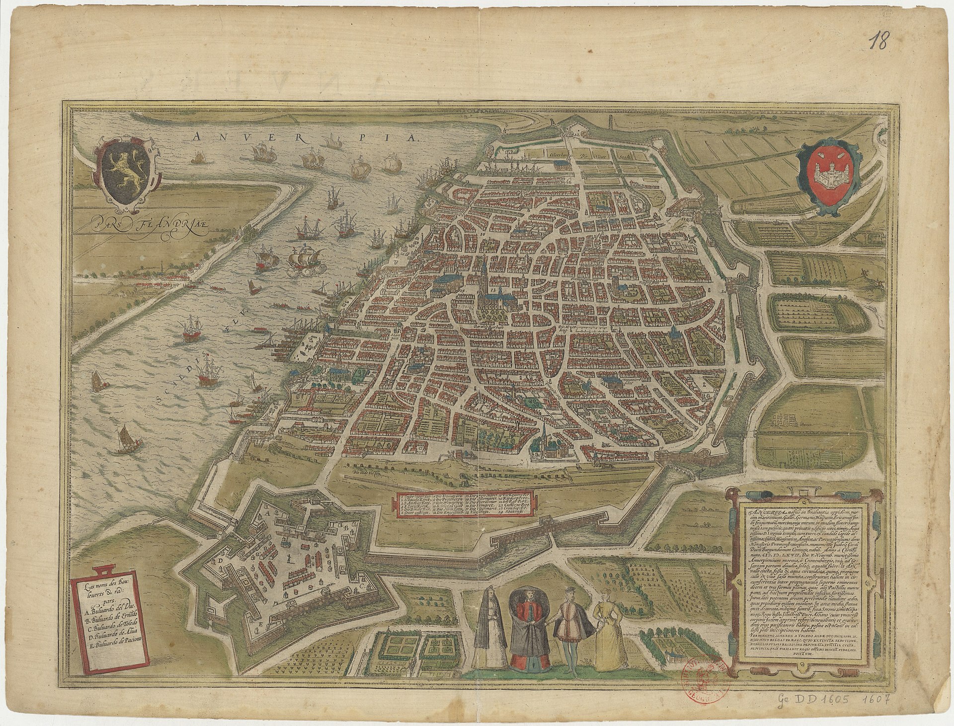
Bird's-eye view of Antwerp (Antverpia), from Braun & Hogenberg's Civitates Orbis Terrarum
Walled old town with bastioned ramparts and citadel, the river Scheldt with shipping, city gates, central cathedral and dense street grid are clearly shown.
Public domain (plate dated 1645)

Castles of Antwerp


More cities to explore
 NetherlandsSaeftingheExplore it in 1570
 BelgiumBrusselsExplore it in 1560 · 1700 · 1900
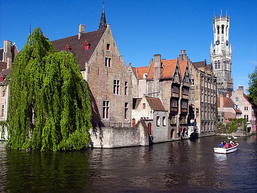 BelgiumBrugesExplore it in 1300 · 1440 · 1895
 BelgiumGhentExplore it in 1350 · 1913
Castles of Europe · Landmarks of Europe · create your own reconstruction.