Historic Cities · Netherlands
Rotterdam through the ages
Rotterdam is the second-largest city in the Netherlands by population and the largest by area (319.4 km2). It is in the province of South Holland, part of the North Sea mouth of the Rhine–Meuse–Scheldt delta, via the New Meuse inland shipping channel, dug to connect to the Meuse at first and now to the Rhine.

Rotterdam in 1690
Golden Age Harbour Town
Rotterdam in 1690 is a compact, walled maritime town whose quays and canals form a triangle of harbours within its ramparts. The walk traces river quays, timbered merchant houses and tree‑lined canals past the Grote Markt, Laurenskerk and Delftse Poort, with East India ships and herring buses at the water's edge.
Red‑tiled roofs huddle within stout brick walls pierced by a few tall church towers. Narrow canals cut between rows of stepped‑gabled merchant houses; limes line the Boompjes beside the Maas. The harbours are dense with masts (small herring boats, flat barges and distant East Indiamen), while windmills turn on the outer ramparts. Streets are cobbled and often wet, with merchants, sailors and porters filling the quays and market squares.
The route: 16 streets, squares and views
Maas Approach → Groothoofd Quay → Boompjes → Oude Haven → Leuvehaven → Wijnhaven → Blaak Canal → Blaak Merchant Houses → Binnenrotte Market → Grote Markt → …
Step inside, 9 interiors
East India Warehouse · Sailmakers' Workshop · Waterside Tavern · Shipchandler's Loft · Marble-floored Voorhuis · Butchers' Hall · Council Chamber · Whitewashed Nave · Gatehouse Guardroom
Planned from the Wikipedia record: Timeline of Rotterdam.
Rotterdam in 1935
The Maas Metropolis
In 1935 Rotterdam is a dense, working port city where steamliners, cranes and warehouse barges press against a medieval core of canals, gabled façades and narrow streets. The walk moves from the river approach through docks, sailor cafés and markets into the civic Coolsingel and finishes at the city's market and exchange quarter.
A low, brick skyline threaded by church towers and the Witte Huis office tower rises from a labyrinth of canals and gabled rows; along the Nieuwe Maas steamers and coastal liners nose past wooden lighters and rusting gantry cranes, while quay warehouses display company names in block letters. Street surfaces are cobble and flag, shopfronts dark wood and enamel, tram wires lace the air and the city smells of coal smoke, tar and fish.
The route: 15 streets, squares and views
Nieuwe Maas Approach → Willemsbrug → Katendrecht Quay → Boompjes Quay → Waalhaven Grain Elevators → Schiedamsedijk → Delfshaven → Hoogstraat → Witte Huis and Oude Haven → Leuvehaven → …
Step inside, 8 interiors
Katendrecht Dance Hall · Shipping Booking Hall · Grain Elevator Engine Room · Harbour Café on the Dijk · Distillery Stillroom · Laurenskerk Nave · Marble Stair · Bijenkorf Sales Floor
Planned from the Wikipedia record: Timeline of Rotterdam.
Its story
The story of Rotterdam.
The Dam on the Rotte, c.950–1350
The settlement at the lower end of the fen stream Rotte (Rotta, from rot, "muddy", and a, "water") dates from at least the year 950. Large floods around 1150 ended development there and forced the building of dikes and dams, among them Schielands Hoge Zeedijk along the northern bank of what is now the Nieuwe Maas. A dam was thrown across the Rotte in the 1260s, where the Hoogstraat crosses it, and the settlement that gathered around the dam lived at first by fishing before it became a trading place with the first harbours. The city's name is the name of that dam.
Count Jan I of Holland granted rights to the people of Rotterdam on 17 March 1299, the origin of the town; it was long assumed those rights were revoked the same year, after the deaths of Wolfert I van Borselen and of the count himself, but that view is no longer generally held. In 1340 Count Willem IV granted city rights again, to a town of only a few thousand people. Around 1350 the shipping canal known as the Rotterdamse Schie was cut, opening a route to the larger towns to the north and making Rotterdam a local trans-shipment point between the Netherlands, England and Germany.
Walls, Jonker Frans and the Revolt, 1358–1600
In 1358 Albrecht of Bavaria gave the town leave to fortify itself. Ramparts and wooden palisades came first, replaced piecemeal by a stone wall that ringed the whole town by the early sixteenth century. Between 1449 and 1525 the late-Gothic St Lawrence's Church was built, the only stone building in medieval Rotterdam, and an ambitious undertaking in a town of roughly 1,200 houses. The philosopher and theologian Erasmus was born here in 1466.
During the Hook and Cod wars Jonker Frans van Brederode held Rotterdam as his base between 1488 and 1490. Nearby Delft lost almost all its ships to him and Gouda half its houses, and the fighting left Rotterdam strengthened against its neighbours. In 1572 troops under Maximiliaan van Hénin-Liétard, stadtholder for the Spanish king, plundered the town; in 1573 Rotterdam, then about 10,000 people, took the side of the Dutch Revolt. Johan van Oldenbarnevelt, the town's pensionary from 1576 to 1586, had the harbour enlarged at the end of the century.
Chambers of the Companies, and the Slave Trade, 1574–1825
The Admiralty of Rotterdam was organised in 1574, and the growing port became the seat of one of the six chambers of the Vereenigde Oostindische Compagnie and one of the five chambers of the West-Indische Compagnie. The census of 1622 counted some 20,000 inhabitants and by the end of the seventeenth century there were around 50,000, yet the town did not build beyond its walls and moats: the roughly triangular 140 hectares between the Coolsingel, the Goudsesingel and the Nieuwe Maas grew badly overcrowded, and only after 1825 did Rotterdam expand past those limits.
From the 1600s the city was involved in the Atlantic slave trade. The historian Gerhard de Kok writes that "Rotterdam merchants were the pioneers of the Dutch slave trade". From the seventeenth century until 1814, when the United Netherlands abolished Dutch involvement at the request of the British government, slave ships out of Rotterdam sailed to Africa and the Americas as part of the triangular trade, and Dutch ships carried enslaved people from Africa to Suriname and the Netherlands Antilles, where they were exchanged for goods shipped back to Rotterdam. The Rotterdam firm Coopstad en Rochussen was, after the Middelburgsche Commercie Compagnie, the largest Dutch slave-trading house. Rotterdam merchants also sold significant quantities of gunpowder to Zeeland-based slave ships.
A Scottish Presbyterian church was built in the town in 1643. In 1661 emigrants who had left from Rotterdam under Arant Van Curler founded a Rotterdam of their own in Schenectady County, New York; in 1942 that town took over the arms of the older city.
The Nieuwe Waterweg and the Farmers' Side, 1827–1900
Through the nineteenth century the silting of the main links to the sea (first the Scheur, then the Brielse Maas) threatened the port. The Voornse kanaal was dug through the island of Voorne between 1827 and 1830 under King Willem I, but as seagoing ships grew larger it no longer answered. The engineer Pieter Caland drew up a new connection to the North Sea; work started in 1866 and the Nieuwe Waterweg was cut between 1866 and 1872, giving Rotterdam a direct passage to the sea at Hoek van Holland. The greatest spurt of growth in both port traffic and population followed its completion.
New basins (the Rijnhaven, Maashaven and Waalhaven among them) were laid out under men such as Lodewijk Pincoffs and G.J. de Jongh, and the work they created pulled in labour from every direction. Farmers, above all from North Brabant and pushed off the land by the agricultural crisis, moved into the city; rows of cheap houses were thrown up for them on the left bank, which was soon called the boerenzij, the farmers' side. Between 1880 and 1900 the population climbed from 160,000 to 315,000. Feijenoord had been absorbed into the city in 1869, Delfshaven followed in 1886, and Kralingen and Charlois in 1895. The Netherlands-America Steamship Company was in business by 1873 and the Koninklijke Rotterdamsche Lloyd by 1875.
Neutral Ground, 1914–1918
Dutch neutrality and a position between Britain, Germany and German-occupied Belgium made Rotterdam the largest spy centre in the world during the First World War. The British secret service kept its main European office on de Boompjes and ran espionage in Germany and occupied Belgium from there; the German services worked out of the imperial consulate-general in the Witte Huis. Many of the spies arrested and executed in Britain had been directed by German agents operating from the city. An average of 25,000 Belgian refugees lived in Rotterdam through the war, along with hundreds of German deserters and escaped Allied prisoners of war.
10 May 1940 to the Hunger Winter
Germany invaded the Netherlands on 10 May 1940. Paratroopers and airlanding troops came down around Rotterdam-Zuid on the first day and the Noordereiland was taken, but the garrison, infantry brought up in support and units of the marine corps kept the Maas bank and the bridges under fire, and the Germans could not reach the centre. On the morning of 14 May they sent a negotiator with a threat to destroy the city, and then carried the threat out. The bombing early that afternoon lasted a quarter of an hour; with the fire that followed it destroyed more than 24,000 dwellings and burned out the heart of the city. The dead are given as about 800 in some accounts and 900 in others (a relatively low figure because many had already fled the fighting), and 80,000 people were made homeless. A German threat to do the same to Utrecht brought the Dutch capitulation on 15 May. The city hall survived.
There were 13,000 Jews in Rotterdam before the war and 11,000 still living there in 1941. Between 30 July 1942 and 22 April 1943, 6,790 people were deported in eight transports through Loods 24; the vast majority of those deported by that route were murdered at Sobibór and Auschwitz-Birkenau. Research published in 2000 found that 144 people survived the deportations. Of the more than 11,000 counted as full or half Jews at the start of the occupation, an estimated 1,400 survived the persecution and the rest of the war's violence. A plaque was unveiled at the memorial wall on the Stieltjesstraat in 1993, and the Jewish Children's Monument in 2013.
On 31 March 1943 Allied aircraft bombed part of Delfshaven by mistake, killing a further 417 people and wounding 400. On 10 and 11 November 1944 some 50,000 men aged between 17 and 40 were seized in a razzia; 8,000 German soldiers had ringed the city the evening before, occupying the main bridges and squares and cutting the telephone lines, and the De Kuip stadium served as one of the principal collection points. Of the men taken from Rotterdam and Schiedam, around 20,000 left on foot towards Utrecht, 20,000 by Rhine barge and 10,000 by train; roughly 10,000 were put to work in the east of the Netherlands and the rest sent to labour camps in Germany. The hunger winter of 1944–45 cost many more lives in the city.
The Basisplan and the Push Seaward
The last large round of annexations came under the occupation, when Hillegersberg, Schiebroek, IJsselmonde, Kralingseveer and the remainder of Overschie were added in 1941. Reconstruction after the war followed the Basisplan adopted in 1946, and in the drive to modernise many damaged buildings were demolished rather than repaired, among them Willem Dudok's Bijenkorf store of 1930. In January 1948 Queen Wilhelmina granted the city the motto Sterker door strijd, stronger through effort, for its coat of arms, as a reminder, in her words, of the courage and strength with which the people of Rotterdam bore all the trials of the war. The Lijnbaan opened in 1953 as the first car-free shopping street in Europe; the new Centraal Station was finished in 1957. Whole districts of flats went up quickly against the housing shortage, and the metro opened in 1968, the first in the Netherlands, tying the districts on the south bank to the centre.
Once the war damage to the harbours was repaired, the port was pushed steadily closer to the sea: the Botlek area, then Europoort, then the Maasvlakte, with large crude-oil storage and refineries at Pernis, Rozenburg and further west. Rotterdam was ranked the world's busiest port by cargo tonnage in 1962 and the world's busiest container port in 1986. Shanghai took the container title in 2004, and in 2006 Rotterdam ranked seventh in the world by twenty-foot equivalent units handled. The Betuweroute, a fast freight railway to Germany, was completed in 2007 and Maasvlakte 2 came into operation in 2013. The port remains the largest in Europe, its main business petrochemicals, general cargo and trans-shipment for the hinterland upstream as far as Basel.
The population peaked at 731,564 in 1965, fell to about 560,000 by 1985 as people moved out to the suburbs and beyond, and stood at 655,468 in 2022; the municipality covers 319.4 km², the largest in the Netherlands by area and the second largest by population. It has the highest proportion in the country of residents with a recent migration background from non-industrialised nations, 52.9% of the population have at least one parent born outside the Netherlands, and the largest Dutch Antillean community in the country lives here. Ahmed Aboutaleb, of Moroccan descent, was mayor from 2009 to 2024 and was the first Muslim mayor of a major European city. The chief congregation of the Remonstrant brotherhood has been in Rotterdam since 1795, the city has been the seat of a Catholic bishop since 1955, and since 2010 it has held the Essalam Mosque, the largest in the country.
From the archive
Rotterdam on paper: the old town as it was mapped.
A period plan or bird's-eye view of the old town, drawn between 1500 and 1850, the streets this page's reconstructions walk. Public domain, with its source named.
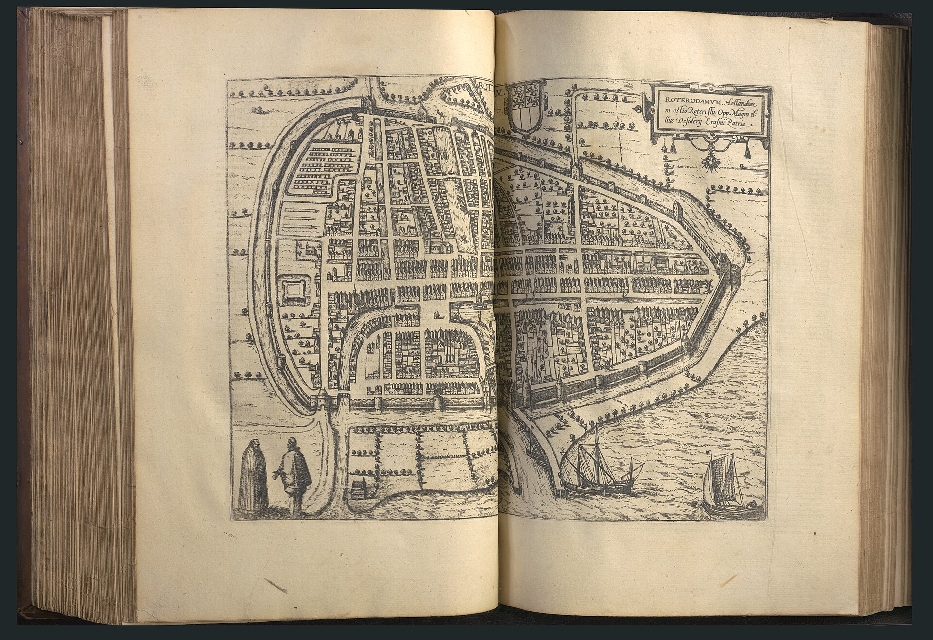
Plan of Rotterdam, from Georg Braun & Frans Hogenberg's Liber Quartus Urbium (1612)
Engraved town plan showing enclosing walls and gates, street grid, canals and quays, church towers and ships in the adjacent waterway.
1612 · Georg Braun · Wikimedia Commons
Public domain (plate dated 1612)

More cities to explore
 NetherlandsDelftExplore it in 1660
 NetherlandsUtrechtExplore it in 1400 · 1700
 NetherlandsAmsterdamExplore it in 1550 · 1660 · 1890
 NetherlandsSaeftingheExplore it in 1570
Castles of Europe · Landmarks of Europe · create your own reconstruction.