Historic Cities · Netherlands
Delft through the ages
Delft is a city and municipality in the province of South Holland, Netherlands. It is located between Rotterdam, to the southeast, and The Hague, to the northwest. Together with them, it is a part of both the Rotterdam–The Hague metropolitan area and the Randstad.

Delft in 1660
Vermeer's Delft
This walk records Delft six years after the great gunpowder explosion, a compact town of potters, brewers and cloth-workers rebuilding solidly after 1654. You will move from the Schie harbour into the Market beneath the Nieuwe Kerk spire, through tree‑lined canals and streets of smoking kilns, past the leaning tower of the Oude Kerk and the quiet Prinsenhof courtyards that know the House of Orange.
Delft in 1660 reads as a low, red‑tiled town pierced by two tall church towers; the Nieuwe Kerk’s spire dominates the broad Markt while the Oude Kerk leans above the narrow canals. Brick gables and classical stone facades sit close to tree‑lined waterways, small wooden quays and clustered potteries whose chimneys and kilns add a thin column of smoke. Streets are narrow and cobbled, the harbour busy with hoys and small merchant ships under cool northern light.
The route: 16 streets, squares and views
View from the Schie → Rotterdamse Poort → Koornmarkt Quay → Wijnhaven Quay → Voorstraat Potteries → Nieuwe Delft → Oude Delft Canal → Paardenmarkt → The Markt → Nieuwe Kerk Spire → …
Step inside, 9 interiors
Brewer's Copper-Hung Hall · Delftware Painting Room · Tiled Burgher Kitchen · Guild of St Luke Meeting Room · Choir around William's Tomb · Aldermen's Council Chamber · Nave under the Leaning Tower · Water Board Council Chamber · Great Stone Chamber
Planned from the Wikipedia record: Delft.
Its story
The story of Delft.
The Dug Canal, the Charter of 1246 and the Rise to 14,000
The town takes its name from the work that made it: the Delf, a dug extension of the Schie, from delven, to delve or dig. At the raised point where that watercourse crossed the creek wall of the silted-up river Gantel, a count established a manor, probably around 1075. Partly because of that seat, Delft became an important market town; the size of its central market square is the evidence.
Having been a rural village in the early Middle Ages, it grew into a city, and on 15 April 1246 Count Willem II of Holland granted Delft its city charter. Trade and industry followed. In 1389 the Delfshavensche Schie was dug through to the Maas, and at its mouth the seaport of Delfshaven was built, giving the inland town its own access to the sea. Until the seventeenth century Delft was one of the major cities of the county, later province, of Holland: in 1400 it had 6,500 inhabitants, third in size after Dordrecht with 8,000 and Haarlem with 7,000, and by 1560, when Amsterdam and Utrecht had reached about 28,000, Delft stood with Leiden and Haarlem at around 14,000 each.
Cloth Seals, Clean Water and the Choice for Beer
One of the first goods traded here was laken, woollen cloth. The wool had to be imported from England and Scotland, since few sheep were kept around Delft, and the cloth made from it was good enough to pass a sequence of formal inspections. Wool arrived at the wanthuis near the Cameretten, recorded as an inspection place as early as 1316; after combing, spinning and weaving the cloth went back for approval and was sealed with lead, then fulled at the Volstraete, today's Voldersgracht, dyed near the Verwersdijk, and sealed again at each stage, the final seal carrying the town arms. Because the lead survives where the cloth does not, archaeologists have traced the weaving quarters from it, and Delft seals found in Amsterdam, Enkhuizen, Hoorn and Leeuwarden show how far the trade reached. They run from the thirteenth century to the end of the eighteenth.
Cloth and brewing wanted the same water for opposite reasons: brewers needed it clean, while cloth-preparers and tanners fouled it heavily. Delft chose largely for brewing, on the reasoning that beer was the best drink available to ordinary people, the well-off drank wine, and milk was barely drunk at all. The oldest known brewery in the Netherlands stood in Delft on what later became the Heilige Geestkerkhof and dates from about 1210. Slightly acidic water was drawn from the peat country north of the town, which also grew the grain and the gruit the beer required, and latrines were ordered emptied into cesspits rather than discharged into the canals; sluices kept the brewers' water apart from the old leather and textile quarter in the east.
The brewers' guild set a quota, at most 155 litres a week, to keep small brewers in business, though large brewers bought up unused quota and sometimes bought the small men out altogether. Output rose from about 155,000 barrels in 1514 to more than 500,000 by 1554, four-fifths of it for export, and around 1550 Delft was the largest beer producer in Holland. The trade carried a train of other work with it (coopers, porters, boatmen, beer merchants and innkeepers), and by about 1500 brewers such as Jan de Huyter were rich enough to face their houses on the town's two main canals in stone.
The Fire of 1536 and the Murder in the Prinsenhof, 10 July 1584
In 1536 a large part of Delft was destroyed by fire. The town's association with the House of Orange began in 1572, when William of Orange, William the Silent, took up residence in the former Saint Agatha convent, thereafter called the Prinsenhof. He was by then leading the growing Dutch resistance to Spanish occupation in the Eighty Years' War, and Delft, one of the leading cities of Holland and walled well enough to serve as a headquarters, suited the purpose. In October 1573 a Spanish attack on the town was repelled in the Battle of Delft. After the Act of Abjuration was proclaimed in 1581, Delft became the de facto capital of the newly independent Dutch Republic as the seat of the Stadtholder, the Prince of Orange.
On 10 July 1584 William was shot dead in the hall of the Prinsenhof by Balthasar Gerards. The family's traditional burial place at Breda was still in Spanish hands, so he was buried in Delft's Nieuwe Kerk, beginning a tradition of Orange burials there that has continued to the present; the vault is sealed between funerals with a cover stone of 5,000 kilograms. The town's nickname is the Prinsenstad, the prince's city. Hugo Grotius, the jurist who laid the foundations of international law, was born in Delft in 1583.
The VOC Chamber of 1602, Delftware and the Delft School
A number of Italian glazed-earthenware makers settled in the town and introduced a new style, and the tapestry industry flourished after the manufacturer François Spierincx moved here; Delft held a prominent position in printing in the same years. The town's second heyday came with the opening of a chamber of the Dutch East India Company in 1602 and the manufacture of Delftware, the blue and white pottery styled on the Chinese porcelain the Company imported. Many potteries took over former breweries, whose vessels and buildings suited the work, and often kept the old brewery names, such as the Griex A and De Dissel.
The same decades made Delft a painters' town. Leonard Bramer, Carel Fabritius, Pieter de Hoogh, Gerard Houckgeest, Emanuel de Witte, Jan Steen and Johannes Vermeer, born here in 1632, all worked in the city; the Delft School is known for domestic interiors, church interiors, courtyards and views of the town's own streets. Reinier de Graaf and Antonie van Leeuwenhoek won international attention for their scientific work in the same period.
The Delft Thunderclap, 12 October 1654
In 1654 Delft was ringed by a city wall with some twenty-six cannon emplacements, and about 30 tonnes of gunpowder were stored in barrels in a magazine in a former Clarist convent in the Doelenkwartier. That so much powder sat in the middle of the town was treated as a state secret, so the inhabitants were generally unaware of it. On the morning of 12 October 1654 Cornelis Soetens, the keeper of the magazine, opened the store to check a sample of the powder. The explosion that followed levelled the central part of the city, left a deep crater, blew out glass over a wide radius including the stained glass and roof of the Nieuwe Kerk, and started fires. It was heard on Texel, some 110 kilometres away. The cause is unknown, Soetens having been killed, though it may have been a spark from the light he carried.
Many inhabitants were away at a market in Schiedam or a fair in The Hague, and casualties were lower than they might have been. A large rescue operation followed; an infant was found alive under the rubble after a day of searching, but few other survivors were. Most accounts state more than a hundred killed and thousands injured, and the exact toll is unknown, with estimates running from a lower bound of 54 to several hundred.
Contemporaries argued over what the blast meant. Some read it as divine punishment and named the sin (the tolerance of a Catholic presence in a chiefly Protestant town, or general moral corruption), which sharpened religious tension; the minister Petrus de Witte held that it was a mercy and a sign to live piously, and the poet Joost van den Vondel concluded that providence is inscrutable. The Delft painter Egbert van der Poel made several pictures of the ruined city. The powder store was rebuilt outside the walls, at 'a cannonball's distance', to a design by the architect Pieter Post, and the worst-hit ground near the blast was eventually turned into the city's horse market, the Paardenmarkt.
Decline after 1672 and the Last of the Potteries
From the Dutch disaster year of 1672 the Delft economy went into decline, overshadowed by its two neighbours: The Hague as the seat of government and Rotterdam as a port. Brewing had already collapsed. The Eighty Years' War cut the export markets in the Catholic Southern Netherlands, Rotterdam and Haarlem competed in the same trade, and drinking habits shifted to tea, coffee and cocoa as wine came within reach of more Delft households; the number of breweries fell from more than eighty in 1600 to seventeen by 1670 and ten by 1740. The last working brewery in the town, the Gekroonde 'P', ran from 1625 to 1922.
The potteries went the same way more slowly. Around thirty firms were engaged in earthenware manufacture at some point near 1670; ten were still active in 1794; and by the nineteenth century one remained, De Porceleyne Fles, which survived because it turned to making bricks alongside its pottery. In 1850 the municipality, then covering 5.3 square kilometres, counted 18,642 inhabitants.
The Academy of 1842, the Railway and the Knowledge City
The slighting of the town walls in the nineteenth century and the opening of Delft's railway station in 1847 made the town attractive to new industry: the Gist- en Spiritusfabriek, later Gist-Brocades and now part of DSM, along with Calvé and Delft Instruments. King William II founded the Royal Academy, an academy for civil engineering, in 1842; it became Delft University of Technology, and the research institute TNO followed in 1932. Martinus Beijerinck, who discovered viruses, lived and worked in Delft, and with Antonie van Leeuwenhoek before him the town has a place in the history of microbiology. In 1866 the first interlocal horse tram in the Netherlands ran in from The Hague along the Oude Delft. On 1 January 1921 the neighbouring municipalities of Vrijenban and Hof van Delft were abolished and largely added to Delft, substantially enlarging its territory.
After the Second World War building began between the canal, the Schie and the Hague–Rotterdam road, and from the 1960s the city expanded hard to the south: first the high-rise districts of Poptahof and Voorhof and the plainer Buitenhof, then from the 1980s Tanthof, to which tram line 1 was extended in 1994. The elevated railway viaduct that had cut the city off from the residential districts west of it was replaced by the Willem van Oranje tunnel with an underground station; trains went below ground at the end of February 2015 and the viaduct was demolished, and the redeveloped corridor was named Nieuw Delft.
Delft is a municipality in the province of South Holland, between Rotterdam and The Hague and part of the Rotterdam–The Hague metropolitan area; it counted 110,044 inhabitants on 1 January 2026, and is the seat of the Delfland regional water authority, housed since 1645 in the Gemeenlandshuis of 1505. Delft University of Technology had 26,502 students enrolled as of December 2025, and the age structure of the town shows it: the share of men aged 20 to 24 was close to three times the national average in 2014. About a million visitors a year come for the historic centre, the pottery and Vermeer.
From the archive
Delft on paper: the old town as it was mapped.
A period plan or bird's-eye view of the old town, drawn between 1500 and 1850, the streets this page's reconstructions walk. Public domain, with its source named.
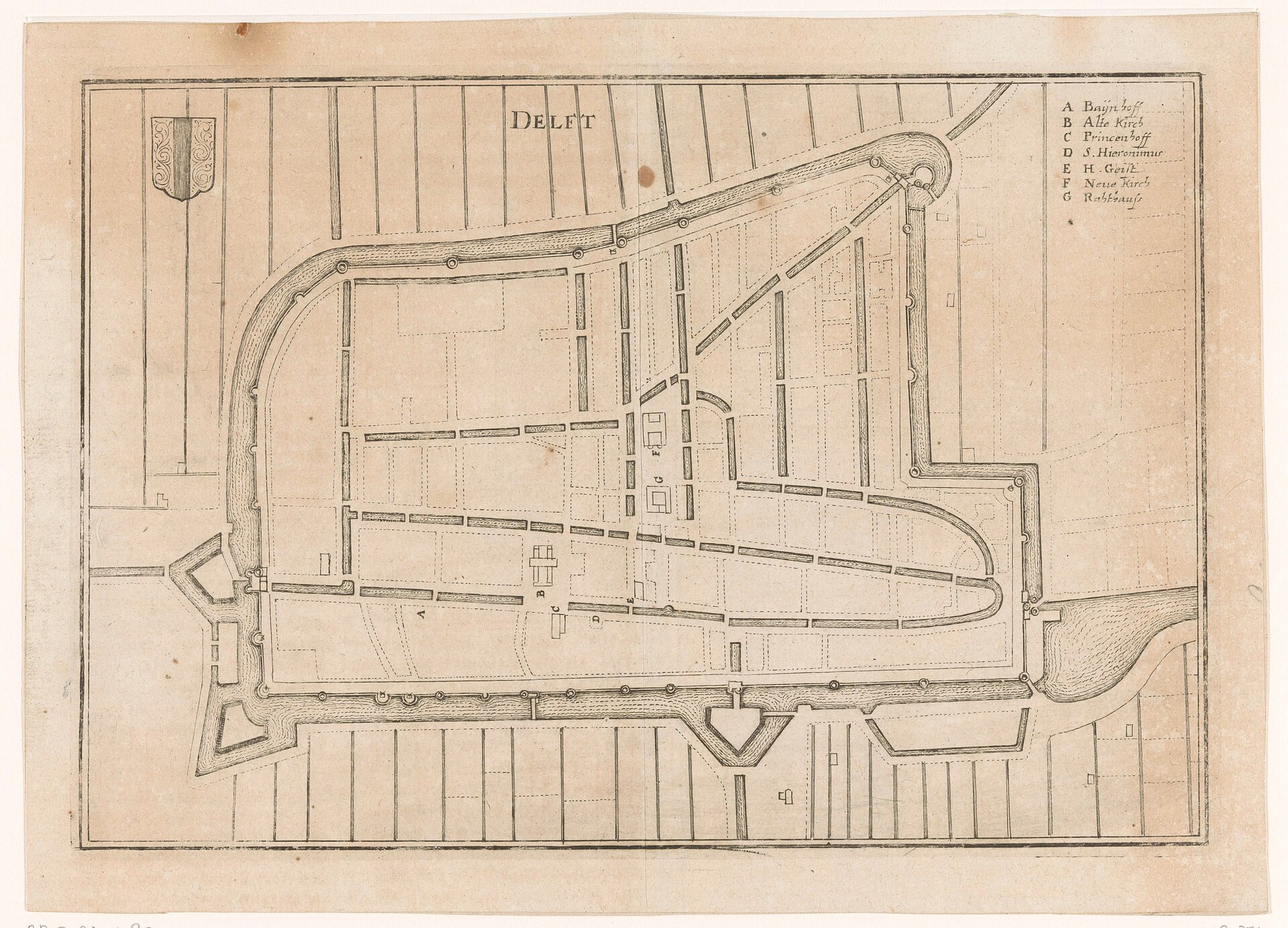
Fortified plan of Delft (Vestingplattegrond van Delft)
Detailed fortified town plan showing Delft’s city walls and bastions, gates, canals, the central market square and the two big churches.
1654 · Rijksmuseum · Wikimedia Commons
CC0 (plate dated 1654)
In this city
Landmarks of Delft, see each in its prime


More cities to explore
 NetherlandsRotterdamExplore it in 1690 · 1935
 NetherlandsUtrechtExplore it in 1400 · 1700
 NetherlandsAmsterdamExplore it in 1550 · 1660 · 1890
 NetherlandsSaeftingheExplore it in 1570
Castles of Europe · Landmarks of Europe · create your own reconstruction.