Historic Cities · England
Chester through the ages
Chester is a cathedral city in Cheshire, England, on the River Dee, very close to the England–Wales border. It had a built-up area population of 92,760 in 2021, it is the most populous settlement in the borough of Cheshire West and Chester. It is the historic county town of Cheshire and the second-largest settlement in Cheshire after Warrington.

Chester in AD 100
Roman Deva
This is Deva Victrix at the height of its life as a legionary fortress and the administrative heart of the Twentieth Legion. The walk follows the fortress ramparts, the principia at the crossing of the main streets, long barrack-rows and granaries, the vast amphitheatre outside the walls, and the working quays on the River Dee where seagoing ships tie up.
A compact, regular fortress of pale local sandstone with straight streets cut in a Roman grid, defended by a turf-and-earth rampart faced with stone and a broad ditch. Towers punctuate the wall at even intervals and barrel-vaulted public buildings and thermae rise above long, gabled barrack blocks. Red tile roofs and whitened mortar catch the low light, the River Dee glints beside quays busy with small ocean-going craft and rowing boats.
The route: 23 streets, squares and views
River Dee Bend View → Racecourse Harbour Shore → South Gate → Principia Crossing → Cardo Maximus → Decumanus Maximus → Principia Forecourt → Elliptical Building → Barrack Rows → Horrea Granaries → …
Step inside, 12 interiors
Principia Cross-Hall · Principia Strongroom · Cardo Merchant's Shop · Baker's Oven Hall · Unfinished Oval Hall · Barrack Dormitory · Granary Store Chamber · Legionary Caldarium · Palaestra Exercise Hall · Amphitheatre Undercroft · Minerva Rock Niche · Quayside Warehouse
Planned from the Wikipedia record: Deva Victrix.
Chester in 1600
Tudor Chester
Chester in 1600 is a prosperous walled market city and river port whose Roman street plan still orders life. Walkers will see the famous two-tier Rows of timber-framed shops, the cathedral that was once the Benedictine abbey, the complete circuit of medieval and Roman walls with the projecting Water Tower, and the Roodee race-meadow by the Dee.
A low, crenellated stone skyline of continuous walls and towers surrounds a dense town of close timber-framed houses with jettied upper storeys and covered upper galleries, the Rows. Sandstone church towers and the squat abbey‑cathedral rise above tile roofs. The River Dee coils beside ramparts and the Water Tower; the Roodee lies as a wide, grassed race‑meadow.
The route: 21 streets, squares and views
The Roodee → Old Dee Bridge → Lower Bridge Street → Bridge Street Rows → The High Cross → Eastgate Row → Eastgate Tower → Cathedral Close → Chester Cathedral Front → Northgate Street → …
Step inside, 12 interiors
Upper Row Draper's Shop · Row Shoemaker's Workshop · Wool Stapler's Counting House · Monastic Cloister · Cathedral Quire · Mercer's Counting House · Watergate Alehouse · Port Watch Chamber · Amphitheatre Arena · Castle Great Hall · Butchers' Shambles · Common Hall Great Chamber
Planned from the Wikipedia record: History of Chester.
Its story
The story of Chester.
Deva Victrix: the Legion on the Dee, AD 70s-410
Chester began as a Roman fort, a castrum named Deva Victrix, founded in the 70s AD during the reign of Vespasian by the Legio II Adiutrix; lead pipes found on the site have been used to date the foundation as early as AD 74. It stood in the land of the Celtic Cornovii, according to the cartographer Ptolemy, and served the Roman expansion northward. The name Deva came either from the goddess of the Dee or from the British name for the river, and the 'victrix' from the title of the Legio XX Valeria Victrix, which was based there. The four main roads of the central city still follow routes laid out at this time.
The fortress was 20% larger than those built at about the same date at York and Caerleon, which has prompted the suggestion that it, not London, was meant to be the provincial capital; a perhaps likelier explanation is that unrest in what is now northern England called for a larger garrison. A civilian settlement grew up around the base, probably beginning with traders who profited from business with the fortress, and the amphitheatre built in the 1st century could seat between 8,000 and 10,000 people.
The legion garrisoned the fortress until at least the late 4th century, and the army had abandoned it by 410, when the Romans withdrew from Britannia. The Romano-British civilian settlement continued, probably with some veterans staying on, and is thought to have gone on using the fortress defences against raiders from the Irish Sea.
Cair Legion: Powys, Mercia and the Danes, 410-973
After the Roman withdrawal the Britons established successor states, and the area of Chester is thought to have formed part of the kingdom of Powys. The place is generally identified with the Cair Legion, 'City of the Legion', listed among the 28 cities of Britain in the 9th-century History of the Britons traditionally attributed to Nennius, a name that gave the modern Welsh Caer. In 616 Aethelfrith of Northumbria defeated a Welsh army at the Battle of Chester, probably settling the Anglo-Saxon position in the area from then on.
In 689 King Aethelred of Mercia founded the Minster Church of West Mercia on what is considered an early Christian site: the Minster of St John the Baptist, later the city's first cathedral. In the 9th century the body of Aethelred's niece St Werburgh was removed from Hanbury in Staffordshire to save it from Danish marauders and reburied in the church of SS Peter and Paul, which became the abbey church and is now the cathedral.
The Anglo-Saxons extended and strengthened the walls against the Danes, who held the city briefly until Alfred seized all the cattle and laid waste the surrounding land to drive them out. It was Alfred's daughter Aethelflaed, Lady of the Mercians, who rebuilt the burh; she dedicated a new church to St Peter in 907, and in about the same year led the defenders who beat off a Viking siege. The Anglo-Saxon Chronicle records that in 973 King Edgar came to Chester after his coronation at Bath and held court at what is now Edgar's Field near the old Dee bridge; he is said to have taken the helm of a barge rowed up the river to St John's by tributary kings, who in the chronicles of Melrose and of Florence of Worcester swear to be faithful to him and to assist him by land and by sea.
The Earls of Chester and the Welsh Frontier, 1071-1398
Chester was one of the last cities in England to fall to the Normans, who took it after the Conquest and the Harrying of the North, destroying 200 houses. The earldom went first to a Fleming, Gherbod, who never took up residence; in 1071 William the Conqueror made his own nephew Hugh d'Avranches the first Earl of Chester. Hugh built a motte and bailey near the river, which Henry III rebuilt in stone in 1245 after the last of the six Norman earls died without issue. The castle was meant to dominate the town and the nearby Welsh border, and the city was both a centre of defence against Welsh raiders and a launch point for raids on Ireland.
The earls were a law unto themselves and kept huge hunting forests, Ranulf I turning the farmland of the Wirral into one of them. Ranulf II helped to capture King Stephen in 1140 and ended up controlling a third of England after backing Henry II's claim to the throne. The independence Chester enjoyed under the earls was confirmed by a charter of Richard II in 1398 declaring that 'the said county of Chester shall be the principality of Chester'.
The first earl endowed a Benedictine monastery dedicated to St Werburgh in 1092, on the site of the church of St Peter and St Paul. A cathedral had been begun in 1075 by the first Norman bishop of Mercia after the see moved from Lichfield to Chester; the see later moved on to Coventry and back to Lichfield, leaving St John's as co-cathedral and collegiate church.
Wine, Furs and the Silting Dee, 1077-1543
The weir above the Old Dee Bridge is not Roman work but was built between 1077 and 1101 by Hugh Lupus, Earl of Chester, to hold water for his river mills. The port flourished under Norman rule: in 1195 the monk Lucian wrote that ships from Aquitaine, Spain, Ireland and Germany unloaded cargoes of wine and other merchandise there, and wine was imported through only four other English ports. In the 13th century Chester was known for its fur trade, and the port was still bringing in large quantities of skins in the mid-16th century: a single ship in 1543 landed 1,600 sheep fells, 68 deer, 69 fawn skins and 6,300 badger skins.
The estuary, however, was silting up, and trading ships had to harbour downstream at Neston, Parkgate and Hoylake; the 14th-century port watch tower, now the Water Tower on the walls, was originally built out into the river. Ashore, the borough won the right to appoint its own sheriffs in 1506, making it a county corporate outside the jurisdiction of the Sheriff of Cheshire. St Werburgh's monastery was dissolved under Henry VIII in 1540 and rededicated to Christ and the Blessed Virgin Mary as Chester Cathedral, and the borough gained city status in 1541 with the creation of the Diocese of Chester.
Siege, Rowton Heath and Plague, 1642-1648
In September 1642, with war between Charles I and Parliament looming, the king visited Chester and ensured the election of a pro-royalist mayor, William Ince. In March 1643 the leading Chester royalist Francis Gamull was commissioned to raise a regiment of foot, and Colonel Robert Ellis built outer defences: a ditch and mud wall from Boughton through Hoole and Newton to the Water Tower, with gun platforms and turnpike gates. Early on 20 September 1645 Parliamentary forces overran those earthworks at the Boughton turnpike and took the eastern suburbs up to the walls. On 22 September a battery in St John's churchyard opened a breach some 25 feet wide near the Roman amphitheatre with thirty-two shots; the storming party that followed was repelled, and by Lord Byron's account the breach was stopped with woolpacks and featherbeds brought from all parts of the town.
On the evening of 23 September the king entered Chester with 600 men over the Old Dee Bridge; that same evening the Parliamentarian Sydenham Poyntz reached Whitchurch, fifteen miles south, with 3,000 horse. The Battle of Rowton Heath was fought the next morning two miles south-east of the city, and the Royalists were crushed. Charles watched the fighting reach the suburbs from the Phoenix Tower on the walls, then withdrew to the cathedral tower, where the captain standing next to him was shot in the head from the tower of St John's, held by the Parliamentarians. Six hundred Royalists were killed, among them the king's cousin Lord Bernard Stuart, Earl of Lichfield, and the composer William Lawes, buried in the cathedral without a memorial. The next day Charles left for Denbigh, with instructions that the city hold out ten days more.
It held out into 1646, refusing to surrender nine times under Lord Byron, until its 17,000 citizens were down to spring water and boiled wheat, having already eaten their dogs, and a treaty was signed with the mills and waterworks in ruins. Despite the treaty the Puritan forces let loose on the city destroyed religious images including the high cross, which was not re-erected for over three centuries; in 1646 Charles I was proclaimed a traitor beside its base. Plague followed the starvation: 2,099 people died between the summer of 1647 and the following spring. Most of the city was rebuilt after the war, and many half-timbered houses of that date still stand.
The Port Lost to Liverpool, the Canal and the Rails, 1762-1869
Chester's port declined as ships from the colonies went instead to Liverpool, though the city remained the main port of embarkation for passengers to Ireland until the early 19th century; the road serving it from Bristol was called the Great Irish Road. The decline became serious from 1762, and by 1840 Chester could no longer compete, although shipbuilding and ropemaking continued. The end of its maritime trade was once put down to the silting of the Dee, but later research indicates the cause was the use of larger ocean-going ships, which diverted traffic to Liverpool and to Mersey rivals such as Runcorn. In the Georgian era the city became instead a place of affluence and elegant terraces where the landed aristocracy lived, and it kept that role through the Industrial Revolution as the upper classes settled a safe distance from Manchester and Liverpool.
A leadworks was set up beside the canal in 1799; its shot tower, which made lead shot for the Napoleonic Wars, is the oldest remaining shot tower in the United Kingdom. The Chester Canal, now part of the Shropshire Union, was dubbed 'England's first unsuccessful canal' after it failed to bring heavy industry to the city. Newtown, north-east of the centre and bounded by the canal, held the large cattle market and Hoole the railways; between them they supplied most of the city's workers and most of its wealth production through the Industrial Revolution. The population stood at 23,115 by 1841.
Building the route to Holyhead produced one notable disaster when a cast-iron bridge over the Dee beside the Roodee racecourse collapsed, alarming the country because many bridges of similar design stood on the growing rail network. Robert Stephenson, the engineer to the new line, was heavily criticised at the inquest, and a Royal Commission confirmed that the design was deficient. In the city itself the Exchange in Northgate Street burnt down in 1862, and the Venetian Gothic town hall built to replace it, designed by the architect William Henry Lynn, was opened by the Prince of Wales in 1869.
Preserved by Design: Chester since 1940
The Second World War fell lightly on Chester: 44 high-explosive bombs and three parachute mines were dropped in all, killing three people, two of them on 28 November 1940, when two mines and 21 high explosives fell. Towards the end of the war a shortage of affordable housing was the greater problem, and farmland on the outskirts was built over as residential districts in the 1950s and early 1960s, producing suburbs such as Blacon. A bypass was driven through and around the city centre in 1964 to relieve traffic congestion.
Local concern at the scale of that redevelopment led in 1968 to a report by Donald Insall, prepared with the local authorities and government, recommending that Chester's historic buildings be preserved; they were consequently put to new uses rather than demolished. The City Conservation Area was designated in 1969, and for the next twenty years the emphasis fell on saving buildings such as the Falcon Inn and the Dutch Houses.
Chester City Council was abolished in 2009 when Cheshire was reorganised into unitary authorities, and the city's status is now held by charter trustees covering the fifteen wards of the former council area, which had 138,875 inhabitants at the 2021 census against 92,760 in the built-up area. The historic county town of Cheshire now lives by service industries: tourism, retail, public administration and financial services. Its walls, nearly two miles round and broken only by a short gap, are the most complete in Britain, and its shopping streets keep the Rows, two levels of galleried shops dating from medieval times and believed to include the oldest shop front in England.
From the archive
Chester on paper: the old town as it was mapped.
A period plan or bird's-eye view of the old town, drawn between 1500 and 1850, the streets this page's reconstructions walk. Public domain, with its source named.
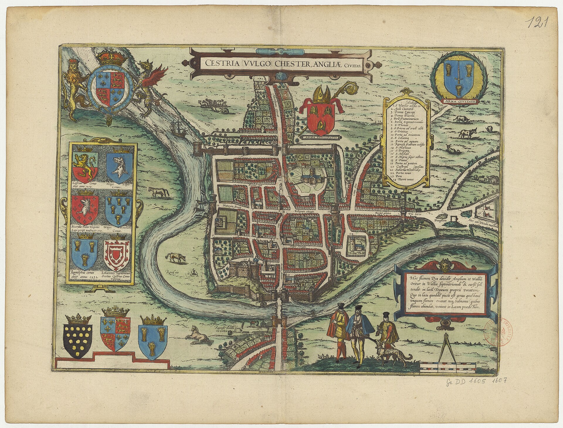
Bird's-eye view of Chester (Cestria), from Braun & Hogenberg's Civitates Orbis Terrarum
Walled medieval town showing gates, a bridge over the River Dee, a clear street-and-block plan and the cathedral within the walls.
Public domain (plate dated 1645)

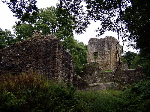
Castles of Chester


More cities to explore
 EnglandLiverpoolExplore it in 1850 · 1910
 WalesCaernarfonExplore it in AD 120 · 1330
 EnglandLondonExplore it in AD 200 · 1390 · 1600 · 1885
 EnglandYorkExplore it in AD 300 · AD 950 · 1420 · 1800
Castles of Europe · Landmarks of Europe · create your own reconstruction.