Historic Cities · France
Dijon through the ages
Dijon is a city and the prefecture of the Côte-d'Or department of the Bourgogne-Franche-Comté region in eastern France. As of 2023, the population of the commune was 161,830, making it the most populous commune in Bourgogne-Franche-Comté.

Dijon in 1450
Capital of the Grand Dukes
Dijon in 1450 is the ducal capital at the height of Burgundian splendour, where Philip the Good’s court draws merchants, craftsmen and pilgrims. The walk passes the rising ducal tower, Notre‑Dame’s arcaded façade with its Jacquemart, the Abbey of Saint‑Bénigne, the goldsmiths' street and the Chartreuse de Champmol beyond the walls.
A compact medieval city ringed by stone walls and low ramparts, its skyline punctuated by the pale stone mass of the ducal palace and the white verticality of the new ducal tower. Steep rows of burgundian polychrome roofs (glazed tiles in greens, blacks and gold lozenges) flash in the sun above timber‑framed houses and narrow lanes. The Ouche river slips past simple quays, cart ruts cut the streets, and banners, velvet cloaks and gilded chains mark the presence of a rich court.
The route: 16 streets, squares and views
Grand'Route de Paris → Porte de la Ville → Rue des Forges → Marché aux Vins → Place Notre‑Dame → Rue de la Chouette → Palais des Ducs → Terrasse du Palais → Tour Philippe‑le‑Bon → Rue de l'Horloge → …
Step inside, 7 interiors
Goldsmith's Forge and Bench · Marché aux Vins Hall · Notre‑Dame Nave · Great Hall of the Dukes · Palace Kitchens with Eight Fires · Choir of Saint‑Bénigne · Champmol Cloister around the Well
Planned from the Wikipedia record: Duchy of Burgundy.
Its story
The story of Dijon.
Divio: The Castrum of 276 and Gregory of Tours' Description
Only the Gaulish root divo-, 'divine', is certain in the name. The ancient castrum has been read as a sacred market, *Divio; the linguist Gérard Taverdet held that the name first belonged to the Suzon, the clear or sacred river, and passed from the water to the town. Thirteen burials of the late Iron Age, between 300 and 200 BC, have been found near the present centre, the adults placed seated in circular pits about a metre across, a treatment of the dead considered very rare. Celtic Divio was the southern metropolis of the Lingones. On the same site archaeologists identified a Gallo-Roman cemetery of more than twenty graves of the first century AD, all of children who died before their first year, buried in stone boxes or wooden coffins with pottery or coins laid inside.
Two Roman roads crossed here, one from Bibracte and Autun towards Gray and Alsace, the other from Italy towards the Paris basin. From the third century the barbarian invasions ended Burgundy's prosperity, and under Aurelian, in the Alemannic emergency of the great invasion of 276, Dijon was walled: an enclosure of only ten hectares, its foundations made partly of stelae, statues and other stone taken from a necropolis, some of the obelisk-shaped stelae recording the names and trades of the inhabitants. The bishops of Langres moved their residence here for a time after the Vandals sacked Langres between 407 and 411, and built a cathedral group of three buildings, Saint-Étienne, Sainte-Marie and Saint-Vincent. Gregory of Tours gave the first written description of the place: four gates set at the four corners of the world and thirty-three towers, walls of dressed stone to twenty feet and rubble above, the Ouche to the south full of fish, the Suzon entering by one gate and leaving by another and turning mills before the gate at great speed, and hills to the west so full of vines that the inhabitants disdained the wine of Ascalon. He added that he did not know why the place had never been called a city.
County, Apanage and the Commune Charter, 500–1183
The Burgundians who held Dijon were defeated by Clovis in 500 or 501. Arab forces invaded in 725; the Northmen failed to take the place in 887. The first counts of Dijon (Aimar, Eliran, Raoul, of the Robertian house) appear in the same period. In 1002 the abbot William of Volpiano began rebuilding the abbey church of Saint-Bénigne, raising within it a rotunda over the tomb of Benignus, the evangeliser of Burgundy; the building was destroyed in 1793 and only its lower storey, the crypt, survives. In 1015 King Robert II tried to take the Dijonnais, attacking Mirebeau-sur-Bèze and then laying siege to the castrum, but gave up the assault before the vigorous resistance of Brunon de Roucy, bishop of Langres, backed by the abbot of Cluny and the count of the town. The bishop's death the next year let the king negotiate with his successor, and in 1016 the county of Dijon passed to the crown of France.
Dijon joined the duchy of Burgundy and became its capital. When Robert II died in 1031 his son Henry I gave up Burgundy and granted Dijon and the duchy in apanage to his brother Robert I, who made the town his capital and began three centuries of Capetian rule there. A great fire reduced Dijon to ashes on 28 June 1137, after which the dukes built a far wider enclosure that held the city until the eighteenth century. Hugh III, caught in a storm on his way to the Holy Land, vowed a church beside his palace to the Virgin and Saint John the Evangelist; work on the Sainte-Chapelle began in 1172, though it was not dedicated until 1500. In 1183 the same duke allowed the drafting of a commune charter, still in the municipal archives, which was widely copied by other Burgundian towns and made the dukes richer.
The Valois Dukes and the Burgundian State, 1363–1477
Philip the Bold took possession of Dijon on the king's order in 1363, the first of four Valois dukes who ruled until 1477 and made it the capital of a state that grew by inheritance and marriage into Picardy, Champagne, the Burgundian Netherlands, Luxembourg, Alsace, Flanders and beyond. He founded his dynasty's burial place at Dijon, the charterhouse of Champmol, and made it a centre of art; Claus Sluter's monumental Well of Moses survives in the town. John the Fearless followed, then Philip the Good, who rebuilt the ducal residence and in 1432 made his palace chapel the seat of the Order of the Golden Fleece.
For all that, Dijon was not a populous place: still rural, and cut back by epidemics, it counted 13,000 inhabitants in 1474. Charles the Bold lived there little, failed in his struggle against the king of France, and was killed at the battle of Nancy against Duke René II of Lorraine, who was allied to Louis XI. The Burgundian state collapsed with him and Louis XI annexed the duchy on 19 January 1477.
Frontier Town: The Parlement, the Siege of 1513 and the Wars of Religion
Dijon submitted to the king despite some revolts. Louis XI transferred the parlement of Burgundy from Beaune to Dijon, which made it a parlementary town where the robe nobility built their town houses, and had a castle put up on the site of the present place Grangier to watch the inhabitants; visiting on 31 July 1479, he solemnly confirmed the town's privileges in the church of Saint-Bénigne. Charles the Bold's only daughter, Mary of Burgundy, married Maximilian of Habsburg and brought him the county of Burgundy and the Flemish possessions, and the Treaty of Senlis of 1493 divided the two Burgundies and left Dijon a frontier town.
In 1513 Maximilian, hoping to recover the duchy, sent 14,000 Swiss free-company troops, 5,000 Germans and 2,000 Franc-Comtois to besiege it. The governor sent to defend the town, Louis II de la Trémoille, got the besiegers away only by playing on the quarrels between Swiss and Germans and promising 400,000 écus, of which only part was ever paid; the Swiss lifted the siege on 13 September and took hostages with them, among them Philibert Godran; la Trémoille negotiated three of them back from Switzerland. The townspeople had prayed hard for deliverance and many put the withdrawal down to the intercession of the Virgin, whose statue, Notre-Dame de Bon-Espoir, had been carried in procession; the episode is commemorated by a tapestry in the town's museum of fine arts. The walls were then strengthened with the Saint-Pierre bastion in 1515, Guise in 1547 and Saint-Nicolas in 1558. Religious troubles ran from 1530 to 1595, and after the Counter-Reformation new churches and monastic chapels were built; a king of France, either Francis I or Henry IV, is said to have called Dijon the town of a hundred bell-towers.
Place Royale, Academy and the End of the Frontier, 1678–1755
When Franche-Comté was joined to the kingdom in 1678 Dijon lost its frontier status and could grow again. Under the princes of Condé, governors of Burgundy, a Place Royale, now the place de la Libération, was laid out in front of the old ducal palace as a setting for an equestrian statue of Louis XIV, cast in 1690 but so hard to move that it was not put in place until 1725. The palace itself, by then the king's lodging, was enlarged into the palace of the dukes and estates of Burgundy; the rue Condé, now the rue de la Liberté, was cut through; and the Condés laid out the large park of la Colombière, joined to the town by a tree-lined avenue.
Dijon was governed by elected Municipaux under the Council of State ruling of 20 April 1668, and with 22,000 to 23,000 inhabitants it was a middling town in the kingdom. A faculty of law opened in 1722 and the Academy in 1725, which gave Jean-Jacques Rousseau the first prize in its competition in 1750; the colleges of medicine had a name of their own from 1755.
Occupation, Mustard and the Liberation of 11 September 1944
Dijon was occupied by the anti-Napoleonic coalitions in 1814, by the Prussian army in 1870–71, and by Nazi Germany from June 1940, when it was bombed by B-17s of the United States Army Air Forces; the French Army and the French Resistance liberated it on 11 September 1944. Despite the occupations the town was largely spared the destruction of the Franco-Prussian War and the Second World War, and its half-timbered houses of the twelfth to fifteenth centuries came through undamaged by organised violence.
Two nineteenth-century Dijonnais changed what the town is known for. The engineer Henry Darcy built a supply of purified water for its citizens a quarter of a century before Paris had one. In 1856 Jean Naigeon substituted verjuice, the acid juice of unripe grapes, for vinegar in the traditional mustard recipe, and Dijon mustard dates from that substitution.
Métropole, UNESCO and the Riots of June 2020
UNESCO registered the historic centre on 4 July 2015 as a component of the Climats, terroirs of Burgundy site, on the ground of its historical importance in regulating the system of wine production in Burgundy. A tram network opened in 2012, line T1 in September and line T2 in December. Dijon is the prefecture of the Côte-d'Or and the seat of Dijon Métropole, and with 161,830 inhabitants in 2023 it is the most populous commune in Bourgogne-Franche-Comté. Its economy rests on a large tertiary sector, food processing (crème de cassis, gingerbread, Lanvin chocolate), and pharmaceuticals; the local drink kir, cassis mixed with white wine, is named after a former mayor of the town, canon Félix Kir. The mustard is no longer necessarily made near the town: Unilever closed its Amora factory in Dijon in 2008, more than 90 per cent of the seed used in local production is imported, mainly from Canada, and the name itself is treated as generic under European Union law and cannot be registered as a protected designation of origin.
From 12 to 16 June 2020 violent clashes broke out in one neighbourhood over several days between drug dealers and Chechens. The riots were described as unprecedented in the town's history, though smaller incidents of the same kind had preceded them at Nice, Rouen and Troyes.
From the archive
Dijon on paper: the old town as it was mapped.
A period plan or bird's-eye view of the old town, drawn between 1500 and 1850, the streets this page's reconstructions walk. Public domain, with its source named.
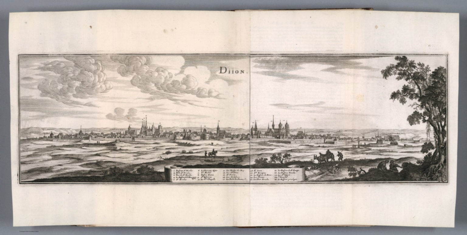
Bird's-eye view of Dijon, from Merian's Topographia Galliae (1660)
Skyline view showing Dijon’s cathedral and church spires, city walls and gates, clustered roofed blocks, and surrounding fields, with an engraved index to landmarks.
1660 · Merian, Kasper, 1593-1650 Zeiller, Martin 1589-1661 · Wikimedia Commons
Public domain (plate dated 1660)
More cities to explore
 FranceLyonExplore it in AD 100 · 1500 · 1835
 FranceAnnecyExplore it in 1610
 FranceParisExplore it in 1250 · 1670 · 1789 · 1889
 FranceRouenExplore it in 1431 · 1540 · 1876
Castles of Europe · Landmarks of Europe · create your own reconstruction.