Historic Cities · Germany
Hamburg through the ages
Hamburg, officially the Free and Hanseatic City of Hamburg, is the second-largest city in Germany after Berlin and sixth-largest city in the European Union, with a population of over 1.9 million. The Hamburg Metropolitan Region has a population of over 5.1 million and is the tenth-largest metropolitan region by GDP in the European Union.

Hamburg in 1450
Hanseatic Hamburg
Hamburg in 1450 is a prosperous Hanseatic port at the head of the Elbe, a compact walled town of brick gables, ringing spires and a maze of fleets and wharves. The walk follows arriving cogs and laden barges into the harbour, along the Alster fleets and market quays, past breweries, the town wall and the great churches to the open water and the Binnenalster skyline.
A low skyline of brick gables and stepped roofs, punctured by narrow church spires and the tall steeples of Saint Nicholas and Saint Peter; narrow, timber-framed houses lean to the canals while red-baked warehouses line the wharves. Muddy tide marks and piled ropes stain the quay; masts and rigging crowd the horizon. Streets are cobbled, damp with river mist, and the city’s colours are ochres, dark reds, soot and wet wood.
The route: 21 streets, squares and views
Elbe Approach → Elbe Quay → Großer Burstah → Nikolaifleet → Quay Crane → Hopfenmarkt → Alsterfleet → Kleine Alster → Steinstraße → Rathausmarkt → …
Step inside, 12 interiors
Salt Warehouse Cellar · Hanseatic Merchants' Diele · Treadwheel Crane House · Hop Weighing House · Steinstraße Counting Hall · Council Chamber of the Rathaus · Nave of Saint Petri · Nave and Altar Aisle of Saint Nikolai · Choir of St. Katharinen · Brewhouse Mash Room and Coppers · Fish Smokehouse · Cloth Hall Inspection Chamber
Planned from the Wikipedia record: History of Hamburg.
Hamburg in 1900
Emigrants' Hamburg
At the height of mass emigration and imperial trade, Hamburg in 1900 is a working port of brick warehouses, steamship masts and crowded quays. This walk follows the river from the Elbe approaches through the Landungsbrücken and Speicherstadt to the Rathaus and the Alster, showing liners, emigration halls, warehouse canyons and the city's civic centre.
The skyline is a low, chimney-creased horizon pierced by masts, church spires and the greenish copper roof of the Neues Rathaus; the river banks show timbered pontoons, iron cranes and endless lines of red-brown brick warehouses. Narrow fleet canals thread the Speicherstadt, quays are crowded with trunks and bales, and the Alster appears as a calm, tree-lined water mirror with steamers on its surface.
The route: 22 streets, squares and views
Lower Elbe Approaches → Neumühlen Quays → St. Pauli Landungsbrücken → HAPAG Elbe Quays → St. Pauli Fishmarket → Baumwall Quay → Kehrwieder Island → Kehrwiederfleet Canal → Holländischbrookfleet → Speicherstadt Warehouses → …
Step inside, 13 interiors
Pontoon Waiting Shed · Shipping Agency Office · Steerage Berth Aboard Liner · Auction Hall · Warehouse Packing Room · Coffee and Carpet Floor · Merchants' Counting Room · Harbour Weighhouse Interior · Medical Inspection Hall · Emigrant Dormitory and Dining · Great Festive Hall · Upper Saloon · Baroque Nave
Planned from the Wikipedia record: History of Hamburg.
Its story
The story of Hamburg.
From Hammaburg to the Battle of Bornhöved
The city took its name from a fortress. In 808 Charlemagne ordered a castle built against Slavic and Viking incursion, and his son Louis raised it in 810 on the old trading path running from Hedeby in the north down to Magdeburg and Bardowick. It stood in marshland between the Alster and the Elbe, and was called Hammaburg, burg meaning fort.
The castle became a mission base: on 25 December 831 Ansgar, later known as the Apostle of the North, was consecrated archbishop for the Hammaburg, and in 834 the place became the seat of a bishopric, later linked with Bremen as the Bishopric of Hamburg-Bremen. It was destroyed repeatedly (by Vikings who came up the Elbe in 845 and burned a town of some 500 inhabitants, by Slavic and Danish forces in 880, by Mstivoj of the Obodrites in 983), and after further raids in 1066 Bishop Adalbert moved permanently to Bremen.
A charter of 1189 from Frederick I granted Hamburg the status of a free imperial city, tax-free passage on the Lower Elbe into the North Sea, rights to fish and cut timber, and freedom from military service. The grant was made orally, in return for Hamburg's backing of Frederick's crusades, and the letter later produced by the town council was in all probability a forgery. Valdemar II of Denmark occupied the town in 1201, and the Danish governor united the bishop's old town and the count's new town under one law, one town hall and one court. Danish defeat at the Battle of Bornhöved on 22 July 1227 freed the town, and it submitted to Adolf IV of Holstein.
The Lübeck Contracts, the Beer Trade and the Rezeß of 1410
Two contracts agreed with Lübeck in 1241, binding both towns to defend their privileges together and to keep the road between them clear of bandits, are taken as the origin of the Hanseatic League. On 8 November 1266 a contract between Henry III of England and Hamburg's merchants allowed them to establish a hanse in London, the first recorded use of the word in connection with the League.
The town lived on the water and on beer, its most important export; three tonnes of it cost one mark, in the currency established in 1377 by the Wendish currency association of Hamburg, Lübeck, Lüneburg, Wismar and Rostock. Its population then stood at about 14,000, making it the third-largest city of the League after Lübeck and Cologne. Force came with the trade: in May 1368 a fleet of 37 ships and 2,000 armed men, two cogs and 200 of them from Hamburg, took Copenhagen and razed it. A great fire on 5 August 1284 had destroyed all but one residential house, and the Black Death arrived in 1350; the toll is given as more than 6,000 dead, about half the inhabitants, and also as at least 60 per cent of the population.
The city's first constitution grew out of a quarrel over a debt. When the citizen Hein Brandt insulted a duke who owed him money, the senate (then formed of the richest citizens, unelected and accountable to no one) had Brandt arrested. Citizens formed a Council of the Sixty and demanded his release, and on 10 August 1410 the senate agreed to twenty articles under which no citizen could be arrested without a hearing and no war begun without hearing the citizens.
Bugenhagen's Church Order and the Merchant Strangers
On 15 May 1529 the city embraced Lutheranism. The senate had asked Martin Luther to send Johannes Bugenhagen to draw up a church order, and his work made a state church: services in Low German, parishes electing their own pastors and doubling as administrative divisions. Roman Catholics lost their citizenship and were told to leave; not until 1785 did the senate acknowledge a small community.
The city took in Reformed refugees from the Netherlands and France. A stock market was founded in 1558, and in 1567 the senate invited a group of English traders to settle, against the rules of the Hanseatic League but for taxes that paid down the city's war debt. Between the autumn of 1696 and the spring of 1697 the Company of Scotland trading to Africa and the Indies worked in Hamburg; it raised no capital locally but commissioned four vessels in the port, launching the Caledonia and the St Andrew in March 1697.
The first Sephardi Jews arrived in the late 1580s, fleeing Portugal, and built a Portuguese Jewish community; senate lists counted about 100 Jewish families in 1610. Lutheran theologians preached against them, calling the synagogues schools of Satan, and in 1611 the senate put the question to the theological faculties of Jena and Frankfurt, which advised that the Jews should be tolerated in the town as strangers. Safety of person was granted, but assaults on individual Jews took place, often triggered by Christian homilies. The community could not worship publicly, though small private prayer rooms were overlooked, and the first small synagogue was not built until 1660.
Bouches-de-l'Elbe: Annexation, Siege and the Constitution of 1860
When the Holy Roman Empire was dissolved in 1806 Hamburg was not absorbed into a larger territory but became a sovereign state styled the Free and Hanseatic City. Napoleon annexed it from 1810, and the city of about 100,000 people became capital of the department of Bouches-de-l'Elbe. It suffered badly under the Continental Blockade, raised two volunteer forces against him, and was besieged for over a year before Russian forces under General Bennigsen freed it in 1814. The Congress of Vienna confirmed the city's independence in 1815.
Fire broke out in the inner city on the night of 4 May 1842 and burned until 8 May, destroying three churches, the town hall and a great many other buildings, killing 51 people and leaving an estimated 20,000 homeless; accounts put the share of the city lost at about a quarter or about a third. Reconstruction took more than 40 years and included the first large modern sanitation system in Europe, the water and sewerage works reorganised from 1842 by the English engineer William Lindley. After the unrest of 1848 the city-state adopted a constitution in 1860 providing for election of the senate by adult taxpaying males, along with the separation of powers, of church and state, and freedom of the press and of assembly.
The Emigrant Port and the Cholera of 1892
Hamburg joined the North German Confederation in 1866 and the German Empire in 1871, keeping its self-ruling status, and in 1888 was one of the last two states, with Bremen, to enter the German customs union. Its fastest growth came in the second half of the nineteenth century, when Atlantic trade more than quadrupled the population to 800,000. Under its director Albert Ballin the Hamburg America Line became the world's largest transatlantic shipping company around the turn of the century, and Hamburg was the port from which most Germans and Eastern Europeans left for the New World.
Cholera broke out in 1892 and was very badly handled by a city government that still held an unusual degree of independence for a German city. The water drawn from the Elbe did not meet modern standards, and the authorities long went on denying there was an epidemic. About 8,600 people died, in the largest German epidemic of the late nineteenth century and the last major cholera epidemic in an important city of the Western world, and the imperial government used the scandal to cut the city's powers sharply.
Revolution, Gleichschaltung and Operation Gomorrah
In early November 1918 revolutionary workers and soldiers took over the city government with little violence, and in March 1919 held a free, equal and universal election for a Bürgerschaft to write a republican constitution; much of the old administration stayed in place, but the senate now depended on the confidence of a chamber elected by the full adult citizenry. On 23 October 1923 communists attempted to seize the city as part of the German October; lacking broad support, the rising was put down by the police, and about 100 people died, many of them bystanders. The Depression hit shipbuilding hard, unemployment reached 40 per cent of residents by June 1933, and in the 1932 election the communists and the Nazi Party together took 47 per cent of the vote.
On 3 March 1933 the Nazi interior minister Wilhelm Frick demanded that the senate suppress the Social Democratic newspaper; when it complied, the three Social Democratic senators resigned, followed by the senate president, and on 5 March Frick used the Reichstag Fire Decree to put an SA officer in direct control of the police. Karl Kaufmann, the Nazi Gauleiter, was installed as Reich Governor that May, and under the law of 30 January 1934 the Bürgerschaft was abolished and the state's powers passed to the central government. The Greater Hamburg Act took effect on 1 April 1937, absorbing the Prussian cities of Altona, Harburg-Wilhelmsburg and Wandsbek and more than two dozen smaller towns.
Systematic deportations of Jewish Germans and of Germans of Jewish descent began on 18 October 1941, to ghettos in occupied Europe or to concentration camps, and most of those deported perished. The city's Jewish religious association was dissolved by decree on 10 June 1943 and its last few employees deported to Theresienstadt on 23 June, where most died. Of the nearly 17,000 Jews living in Hamburg before Hitler came to power, about 7,800 were murdered in the Holocaust. A concentration camp operated at Neuengamme from 1938 to 1945, where at least 42,900 people are thought to have died, and between 1939 and 1945 more than 500,000 men, women and children, prisoners of war among them, were made to work for over 900 companies and housed in more than 1,200 camps across the city. On 23 July 1943 RAF and United States Army Air Force firebombing, codenamed Operation Gomorrah, created a firestorm that destroyed the densely populated working-class boroughs of Hammerbrook, Billbrook and Hamm South; at least 42,600 civilians were killed, and the precise number is unknown. By May 1945 half a million people, some 35 per cent of the population, had left.
The British Zone, the Flood of 1962 and HafenCity
The city was surrendered to British forces on 3 May 1945 and remained under British occupation until 1949, when it became a state of the Federal Republic. War crimes trials were held at the Curio house in Rotherbaum, and in 2009 more than 2,500 Stolpersteine were set into the pavements outside the former homes of deported and murdered citizens. The inner German border, only 50 kilometres to the east, cut the city off from much of its hinterland and reduced its trade, and on 16 February 1962 a storm drove the Elbe to a record height, flooding a fifth of Hamburg and killing more than 300 people.
After reunification in 1990 and the accession of eastern European and Baltic states to the European Union in 2004, the port set out to regain its standing as the region's largest deep-sea container port. From 2008 a section of the old port on the Elbe island of Grasbrook was converted into the mixed-use HafenCity, and in 2015 the Speicherstadt warehouse district and the adjacent Kontorhausviertel were inscribed as a UNESCO World Heritage Site. Hamburg is now the second-largest city in Germany after Berlin, with a population of over 1.9 million, and its port is Germany's largest and Europe's third-largest after Rotterdam and Antwerp.
From the archive
Hamburg on paper: the old town as it was mapped.
A period plan or bird's-eye view of the old town, drawn between 1500 and 1850, the streets this page's reconstructions walk. Public domain, with its source named.
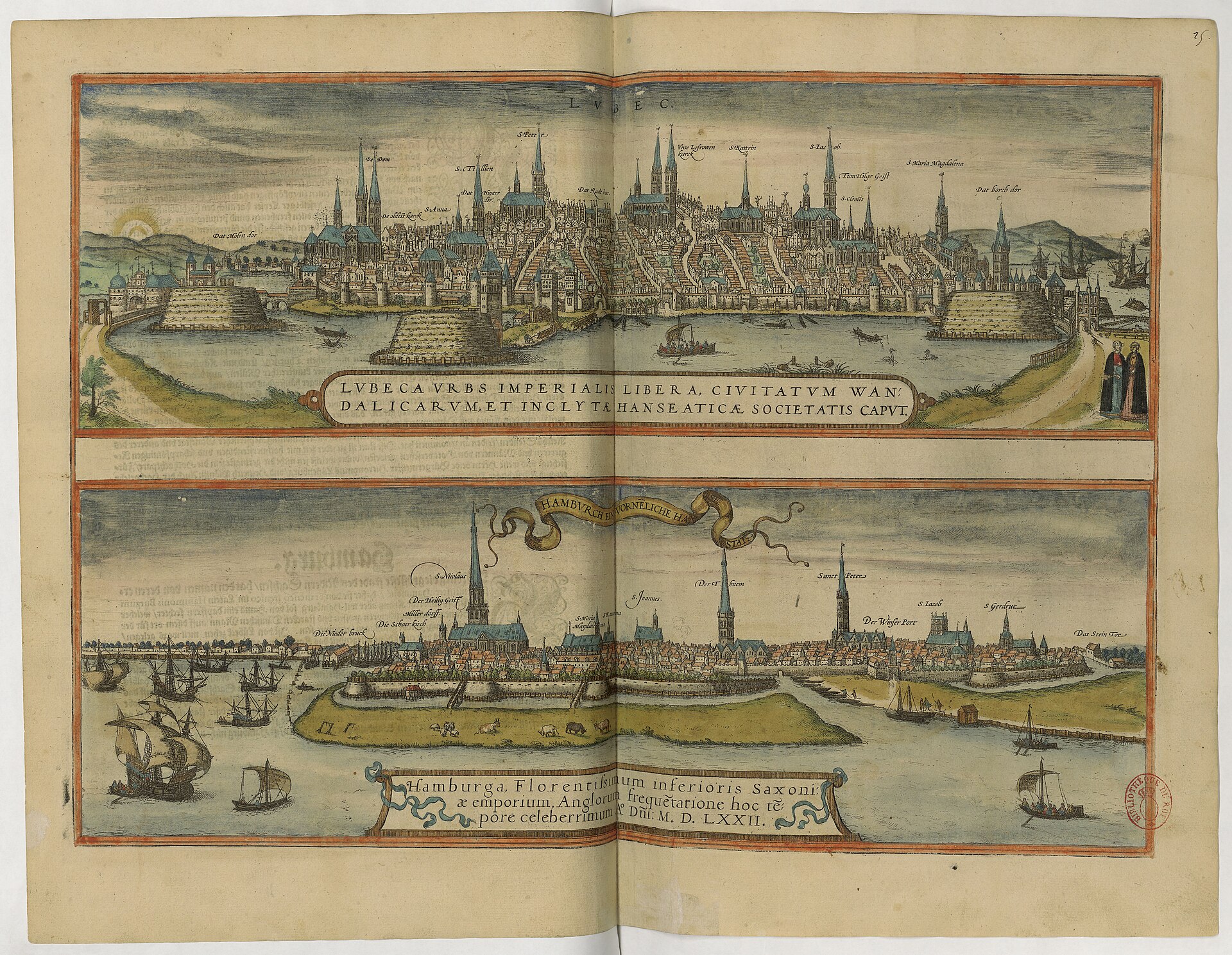
Hamburg, prospect from Braun & Hogenberg's Civitates (Braun & Hogenberg), 1572
Side-on harbour prospect of Hamburg showing the river frontage, fortified walls and bastions, multiple church spires and moored ships.
Public domain (plate dated 1572)

Ships tied to Hamburg
- Admiral Hipper: Blohm & Voss laid her keel at Hamburg on 6 July 1935
- SMS Derfflinger: Keel laid at Blohm & Voss in Hamburg on 30 March 1912
- SMS Goeben: Ordered from the Blohm & Voss shipyard in Hamburg in 1909
- SMS Moltke: Taken from Hamburg to Kiel to commission in 1911, and repaired there in 1912
- U-995: Laid down at Blohm & Voss in Hamburg on 25 November 1942
More cities to explore
 GermanyLübeckExplore it in 1500 · 1900
 GermanyRungholtExplore it in 1361
 GermanyBerlinExplore it in 1750 · 1871 · 1928
 GermanyMunichExplore it in 1500 · 1700 · 1900
Castles of Europe · Landmarks of Europe · create your own reconstruction.