Historic Cities · Germany
Rungholt through the ages
Rungholt was a low-lying settlement in North Frisia, in what was then the Danish Duchy of Schleswig. The area today lies in Germany. Rungholt was flooded, with massive erosion, when a storm tide hit the coast on 15 or 16 January 1362.

Rungholt in 1361
Before the Grote Mandrenke
Rungholt is a prosperous marshland trading town on the island of Strand in the Duchy of Schleswig, at the height of its dyke-built agriculture and sea-borne commerce. The walk passes the outer sea dyke and wooden sluices, the small sielhafen with Hamburg beer and Flemish cloth, rows of grass-sod houses on warfts, the large parish church and the reclaimed fields grazed by cattle.
Rungholt sits low on the horizon as a scatter of grassy warfts and turf roofs punctuated by a substantial brick church tower; most houses are built of grass sods, low and earthbound, while wooden piers, raised store platforms and a broad turf-faced dyke edge the tidal flats. The harbour works are timber and oak, sluices large and clumsily patched, and the general palette is peat-brown, wet green and the dull red of brick under a northern, wind-flattened light.
The route: 9 streets, squares and views
View from the Wadden Sea → Outer Dyke and Sluice → Sielhafen Harbour → Quay and Storehouses → Market Warft → Main Church Warft → Cloth Row and Weavers → Dyke-top Reclaimed Fen → High Warft Overlook
Step inside, 5 interiors
Reeve's Sod Hall · Oak Cask Storehouse · Weighhouse Hall · Nave of the Apse · Upper Textile Loft
Planned from the Wikipedia record: Rungholt.
Its story
The story of Rungholt.
Chief Place of the Edomsharde
Rungholt was a settlement and a legal district, a Dingspil, in the North Frisian coastal landscape of Strand, in the Duchy of Schleswig and so in the Danish kingdom of the day; from the thirteenth century it was a parish as well. Two adjoining settlements, Grote Rungholt and Lütke Rungholt, together formed the chief place of the Edomsharde, one of five Harden into which Strand was divided. Strand belonged to the Uthlande, settled by Frisians from the Viking age onwards. Its close neighbour Niedam was lost in the same century Rungholt was. The ground it stood on now lies in Schleswig-Holstein, mostly under the tidal flats of the Wadden Sea.
The name is generally derived from the Frisian prefix Rung-, meaning wrong or lesser and sharing a stem with the English word wrong, together with holt, a wood, giving a sense of low wood. Historic maps support that reading by marking a small wood on rising ground near the place, the Silva Rungholtina, which was a very unusual thing in that country. The name scholar Wolfgang Laur, working from fifteenth-century forms of Rungeholt, read it instead as a wood from which poles, Rungen, were fetched.
Diked Peat, Turf Mounds and Salt from Sea Turf
The land lay below sea level and had to be made. Two timber water structures stood about 500 metres north-west of Lütke Rungholt, and they date the reclamation: works of that kind lasted some eighty to a hundred years, so the younger is unlikely to have been built before 1280 and the older around 1200, which is when the area was first diked and such works first became necessary. Andreas Busch, who surveyed both between 1922 and 1929, found them unusually large for the period and found that the older had sprung a leak and had to be replaced. Busch took the two for locks; a later reconstruction calls them Siele, drainage culverts of the sort Peter Sax's chronicle mentions, too shallow to have drained much land.
Ditches across the fields inside the dyke fed water to them. The dyke has been reckoned at about two metres high, inferred from the width of the hollows its weight pressed into the peat and which remained after the sea carried the earth off; at points the repairs are still legible as pits where turf was cut and piles driven to hold new material at a breach. No trace of a town wall has been found. Houses stood on Warften, mounds raised in some twenty layers of turf against wind and waves, more than fifty of them, turf being the ordinary building material where brick was scarce for want of clay. The people lived by cattle, by salt won from sea turf and by trade, and grew grain, chiefly rye, on ridged fields around the settlement.
A Hamburg Agreement, Rhenish Stoneware and a Count of Wells
No contemporary written account of the settlement survives, and the documents describing Rungholt mostly date from the sixteenth century and later. The name itself appears in a will of 1345, and in a trade agreement made with Hamburg merchants on 1 May 1361, eight months before the flood. That agreement, along with finds of Rhenish jugs, supports the view that Rungholt was the main harbour of the Edomsharde.
Pottery recovered from the area is mostly of the thirteenth and fourteenth centuries, and about 30 per cent of it is imported, a proportion not otherwise known from Wadden Sea finds, and consistent with the heavy taxation the Waldemar Erdbuch records for the Edomsharde. Most of the imported ware is stoneware from Rhenish potteries; there is also a Moorish jug from Spain and red earthenware from Scandinavia, most of it made in the middle of the fourteenth century. With the metal finds (bronze cooking vessels, brooches, weapons, a small balance) the pottery limits the occupation to roughly the century and a half before the settlement was lost.
How many people lived there is not agreed. Busch, reasoning from the number and spread of the wells (about a hundred were found, each probably serving two or three households) put the population at 1,500 to 2,000 at least, which he noted was as many as Kiel had at the time, against about 5,000 at Hamburg. A later reconstruction gives 1,000 to 2,000; other archaeological estimates run to as many as 500 houses and about 3,000 inhabitants.
The Grote Mandrenke of 1362 and the Floods After It
The storm tide known as the Grote Mandrenke, or Den Store Manddrukning, and sometimes named after Saint Marcellus, struck the coast on 15 or 16 January 1362, and Rungholt was flooded and heavily eroded. Estimates put the number of dead at around 25,000. Perhaps thirty settlements were destroyed, and the coastline shifted east, leaving land that had been farmed and lived on out in the tidal flats.
The settlement's vulnerability has been attributed to the reclamation that made it possible. What had been peat bog and fen, barely habitable, was colonised completely and the landscape altered with it; once the peat was cut away and the water taken off, the soil left behind was very rich and well suited to agriculture, but with rising sea levels and increasing storminess the dykes that had been built eventually proved insufficient and the settlements drowned.
Strand itself was largely destroyed by the Burchardi Flood of 1634. Of the old Nordstrand there remained the island of Nordstrand, the island of Pellworm and the Hallig Nordstrandischmoor, with Hallig Südfall alongside them and the rest now tidal flats. Parts of the former Rungholt district were diked again in the intervening centuries; the Hensebek-Koog was won in 1624.
Boetius's Cauldrons, Busch's Maps and Duerr's Rival Site
For a long time there was no material evidence from before 1362 that could prove the settlement had existed at all. One of the earliest pointers is De Cataclysmo Norstrandico by Matthias Boetius, who wrote of frequent finds of tracks, ditches and metal cauldrons in the mudflats, but who, following oral tradition, dated the loss of the settlement to a storm tide in 1300. The seventeenth-century chroniclers Peter Sax and Anton Heimreich also reported such finds and passed on tales of a town lost in the fourteenth century. Johannes Mejer's map of 1636, said to rest on a model of 1240, later gave researchers something to test the ground against.
Around 1880 a fisherman came upon large timbers in the mudflats where the water structures were later identified, and took them for a wreck; plough marks in drowned fields, pottery, brick fragments and a few swords, now in the Nordfriesisches Museum in Husum, kept coming to light. Between 1921 and 1938 the tides north of Hallig Südfall exposed remains of Warften, other buildings, the foot of a dyke, wells and cisterns; the sea destroyed them quickly, but they were systematically recorded first and confirmed detail already shown on the old maps. Busch mapped twenty-eight mounds from the early 1920s onwards and, by setting his map against the surviving ones, was able to place Lütke Rungholt, Grote Rungholt and Niedam. In the cluster identified as Grote Rungholt a single mound had no well at all; because the church was then the only building needing no water supply of its own, it was taken for the church mound.
In 1994 the dating of the timber structures was publicly disputed, with a good deal of press attention, after the ethnologist Hans Peter Duerr made further finds north-west of Busch's and called that the true site of Rungholt. Radiocarbon dating is held to have confirmed the age of the timbers, and Duerr's finds have since been assigned to Frederingscap vel Rip, a neighbouring place also lost in the flood but afterwards rebuilt.
The Church Traced in May 2023
In May 2023 a team of geophysicists, geographers and archaeologists (from the universities of Mainz and Kiel, the Centre for Baltic and Scandinavian Archaeology and the Archaeological State Office of Schleswig-Holstein) traced, not far from Hallig Südfall, the foundations of a brick church with a broad tower resembling that of the old church on Pellworm, and a rounded apse. At 40 by 15 metres it was markedly larger than village churches of the time, its dimensions close to those of the church at Breklum, which likewise served beyond its own district. It stood on a former mound belonging to a chain of medieval Warften two kilometres long that had not been known before, and it is taken to be the centre of the Rungholt settlement pattern; Rungholt is described as having had three places of worship, a main church and two smaller ones.
Across ten square kilometres the survey identified at least fifty-four former mounds, a sea dyke with a sluice harbour, drainage systems and two smaller church buildings, with a harbour proven a little to the south. In June 2023 the German Research Foundation announced that researchers had confirmed the identification of the remains around Hallig Südfall, first found in 1921.
Heimreich's Drunken Pig and Liliencron's Ballad
The real Rungholt was a farming trade harbour on a well-navigable river, built largely of turf houses. After it was lost its wealth was described in steadily more splendid terms, and fantastic notions grew up about the size and riches of the town. The legend was first handed down by Anton Heimreich, in the context of the second great Mandränke, the Burchardi Flood of 1634, and in it the loss is a divine punishment for vice and for disrespect towards the church: farmers at an evening drinking bout are said to have made a pig drunk and then pressed a priest to give it the last sacraments, and after threats and mockery he took refuge in the church, where a dream that night warned him of the coming catastrophe and he left the island in time. The story may go back to a nearly identical account in the Dialogus miraculorum of Caesarius of Heisterbach, in which God's anger at a desecration of the sacrament brings on a storm tide; Caesarius attached his version to the First Marcellus Flood.
Other tellings have the bells of Rungholt still audible beneath the water when the weather is calm, and the town rising whole out of the sea every seven years on St John's Night, motifs that attach to other drowned places, Vineta among them. Karl Müllenhoff printed the legend in 1845 in his Sagen, Märchen und Lieder der Herzogtümer Schleswig, Holstein und Lauenburg, and Theodor Storm gave the myth a place in his 1871 novella Eine Halligfahrt. In 1882–83 Detlev von Liliencron wrote the ballad Trutz, blanke Hans, which opens “Heut bin ich über Rungholt gefahren, die Stadt ging unter vor sechshundert Jahren”, today I travelled over Rungholt; the town sank six hundred years ago. Achim Reichel set the ballad to music on his 1977 album Regenballade, and the group Santiano recorded a song called Rungholt in 2015. The place is sometimes called the Atlantis of the North Sea, and the Mythos Rungholt takes up a broad part of the Nordfriesisches Museum in Husum.
From the archive
Rungholt on paper: the place as it was mapped.
A period map that sets the place down, drawn between 1500 and 1850, the ground this page's reconstructions walk. Public domain, with its source named.
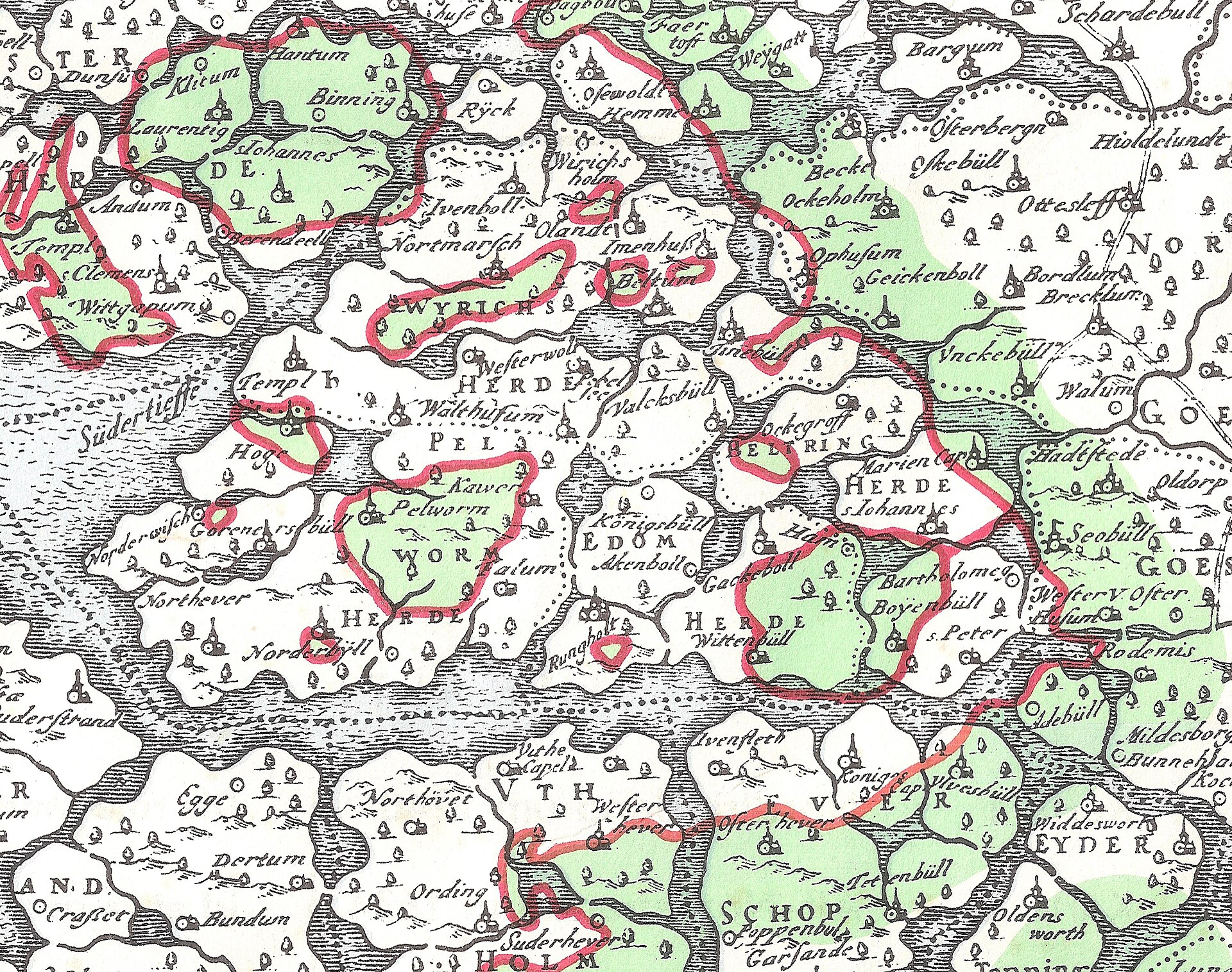
Rungholt on Johannes Mejer's map of Nordfriesland as it lay before the 1362 flood
Rungholt sits on its own island in Edomsharde with a church symbol beside it, among the Pelworm, Beltring and Wittenbüll parishes that the Grote Mandrenke carried away.
1652 · Johannes Mejer · Wikimedia Commons
Public domain (plate dated 1652)
More cities to explore
 GermanyHamburgExplore it in 1450 · 1900
 GermanyLübeckExplore it in 1500 · 1900
 GermanyBerlinExplore it in 1750 · 1871 · 1928
 GermanyMunichExplore it in 1500 · 1700 · 1900
Other lost towns of Europe: Dunwich · Ravenser Odd · Vineta · Ys · Kitezh.
Castles of Europe · Landmarks of Europe · create your own reconstruction.