Historic Cities · England
Dunwich through the ages
Dunwich is a village and civil parish in Suffolk, England. It is in the Suffolk & Essex Coast & Heaths National Landscape around 92 miles (148 km) north-east of London, 9 miles (14 km) south of Southwold and 7 miles (11 km) north of Leiston, on the North Sea coast.

Dunwich in 1280
The Great Port of Suffolk
This walk visits Dunwich at its height, a generation before the great storms that began in 1286. Expect a busy coastal town of many church towers, crowded quays and friaries on the cliff, where herring and wine ships lie at anchor and parish life fills narrow streets.
In 1280 Dunwich presents a low, clustered skyline of flint-and-freestone church towers and timber-framed houses, all pressed close to a narrow headland and shingle banks. The harbour is a forest of masts and sails (coastal herring busses, Flemish and English trading cogs with wine barrels on deck), while gulls and salt spray blur the line between sea and quay. Streets are narrow, rutted and wind-scoured; friaries and hospital walls punctuate the town's compact profile under a pale, often windy North Sea light.
The route: 10 streets, squares and views
Dunwich Headland → Shingle Spit → Dunwich Harbour → Shipowners' Hall → Maison Dieu Hospital → Market Place → All Saints' Church → Greyfriars → Blackfriars Priory → Dunwich Hill
Step inside, 5 interiors
Quay Merchants' Hall · Hospital Infirmary · Covered Market Hall · Parish Nave · Friars' Refectory
Planned from the Wikipedia record: Dunwich.
Its story
The story of Dunwich.
Dommoc and the East Anglian Bishops, c. 630-870
In the Anglo-Saxon period Dunwich was the capital of the kingdom of the East Angles, and since the 15th century the place has frequently been identified with Dommoc, the original seat of the East Anglian bishops, established by King Sigeberht for Saint Felix in about 629–31. That identification is not settled: the historian Rory Naismith writes of the bishopric of Dunwich, while Richard Hoggett places Dommoc at Walton Castle instead. Whichever site held the bishop's chair, it was a see until around 870, when the East Anglian kingdom was taken over by the initially pagan Danes. Underwater survey has since confirmed that Dunwich was a substantial port in Saxon times.
The Harbour at the River Mouth, 1086-1322
Dunwich existed because of a sheltered harbour formed where the River Dunwich met the North Sea. The Domesday Book of 1086 records three churches and the town's population at that date is estimated at 3,000; at its height it was an international port covering an area comparable to 14th-century London, though with far fewer people in it. By the 13th century the town supported eight churches along with religious houses of every kind: a Franciscan friary, a Dominican priory founded in the reign of Henry III by Roger Holish, the leper hospital of St James, and a preceptory of the Knights Templar thought to have been founded around 1189 and built to a circular plan like the Temple Church in London.
The Templar house was substantial enough to serve as a strongroom. In his accounts for 1309 the sheriff of Suffolk and Norfolk recorded finding £111 14s 6¼d there in four pouches, a large sum lodged with the Templars for safekeeping by Robert of Seffeld, parson of Brampton. In 1322, on Edward II's orders implementing the papal bull Ad providam, all the Templars' land passed to the Knights Hospitaller.
The Storms of 1286-1362 and the River that Moved North
On 1 January 1286 a storm surge reached the eastern edge of the town and destroyed buildings; before that, the recorded damage had been loss of land and harm to the harbour. Two more surges followed the next year, the South England flood of February 1287 and St Lucia's flood that December. A fierce storm struck on 14 January 1328, another in 1347 swept some 400 houses into the sea, and the Grote Mandrenke of around 16 January 1362 destroyed much of what was left. The Franciscan friary, originally founded nearer the shore, was moved inland after the New Year storm of 1286 and flourished on its new site until the Dissolution in 1539.
The common account of a busy port lost to 14th-century storms is, however, inaccurate. Coastal processes including the storms pushed the mouth of the river 2.5 miles north to Walberswick on the River Blyth. With the harbour gone, the town lost its reason for being and was largely abandoned; the sea defences were not maintained, and erosion then stripped away the site over the centuries that followed.
The Churches Go Over the Cliff, 1335-2022
The losses ran on for centuries, church by church. St Leonard's had already fallen in the 14th century and St Nicholas's soon after the Black Death; St Martin's, built before 1175, went between 1335 and 1408. St John the Baptist's was dismantled in the 1540s. The Temple, having passed from the Hospitallers at the Dissolution, was demolished in 1562, and its foundations washed away in the reign of Charles I. The east gable of St Peter's fell in 1688 and the rest of the building in 1697; its parish register survives and is now in the British Library. The last building of the Dominican priory fell into the sea in 1717, though the friars had begun preparing to move to Blythburgh as early as 1385.
All Saints', the last of the old churches, had no rector after 1755 and was abandoned in the 1750s once the parishioners judged they could no longer afford its upkeep, although burials continued in the churchyard into the 1820s. A replacement church, St James's, was built in 1832. The stages of the ruin's decay were recorded in a print by W. Watts in 1776, a hand-tinted print by J. P. Neale in 1813 and an oil painting by Thomas Lingwood in 1904; alongside those topographical exercises, J. M. W. Turner painted a more artistic view in a watercolour of about 1827. The cliff edge reached the church in 1904; accounts differ on the end of the tower, one dating the fall of its last major portion to 12 November 1919 and another to 1922. One of its buttresses was salvaged and stands in St James's. Of the graves, the stone of John Brinkley Easey went over the cliff in the early 1990s, and by 2022 a single stone remained, that of Jacob Forster, who died in the late 18th century, about 15 feet from the edge.
Two Members of Parliament for a Vanishing Borough, to 1844
What the town lost in substance it kept in political form. The parliamentary constituency of Dunwich retained the right to return two members to Parliament until the Reform Act 1832, and was one of Britain's most notorious rotten boroughs. The town hall itself was lost to the sea and the corporation moved into a cottage, which survives as the Old Town Hall. By the middle of the 19th century the population had fallen to 237, and in 1844 the place was described as a decayed and disfranchised borough.
Radar Station and Invasion Rehearsal, 1943-1948
RAF Dunwich, on Dunwich Heath, was one of the Chain Home Low stations giving low-level radar cover to the central East Anglian coast during the Second World War. The same stretch of coast was used by the military in 1943 to rehearse the Normandy landings of the following year, in an exercise named Operation Kruschen. The official war artist Edward Bawden made coloured sketches of the exercise and, taken with the area, returned in 1948 to paint there again.
Sonar Over the Drowned Town, 2005-2015
The marine archaeologist Stuart Bacon stated in 2005 that recent low tides had shown shipbuilding had been carried on in the town. The Dunwich 2008 project, funded by English Heritage and the Esmée Fairbairn Foundation, set out to bring every reliable historic map of the town onto a single coordinate system and combine it with aerial photography and an underwater survey. New digital maps were produced by Professor David Sear of Southampton University, the marine archaeologist Stuart Bacon and the Geodata Institute, and multibeam and sidescan sonar was used to map the seafloor across the whole area of the town. Divers confirmed a series of ruins and recovered stones with lime mortar still attached, a near-perfect match for the medieval mortar in surviving churches along the coast. Wessex Archaeology took higher-resolution sidescan images in 2009, and in 2010 acoustic imaging cameras filmed the ruins through the turbid water for BBC Oceans and The One Show. A further English Heritage survey commissioned in 2011 and reported in 2012 compiled the earlier data into what has been described as the most comprehensive record of the site, the largest medieval underwater site in Europe.
The surveys have identified the ruins of St Peter's and St Nicholas's churches, a chapel most probably St Katherine's, and remains associated with the Dominican priory and the town hall; the Templar church and All Saints' are located on the digital maps but lie buried under an inner sandbank, and the early town is under one to three metres of sand further east. Diver work and land archaeology scheduled for 2013–15 under the Touching the Tide scheme, funded by the Heritage Lottery Fund, aimed to date the town ditches and roads and to read the record of environmental change in the marsh sediments. The results, and the story of the town's 800-year fight against erosion, are displayed in Dunwich Museum. Dunwich itself is now a village and civil parish in East Suffolk with no parish council, only a parish meeting; the 2001 census recorded 84 residents and the 2011 census 183, on an area that also took in part of the neighbouring parish of Westleton.
The Bells Beneath the Waves and the Dark Heart of Dunwich
The site has attracted its own body of story. A well-known local legend holds that at certain tides church bells can still be heard from beneath the waves, and a Suffolk tale whose origins appear to lie in the 12th century, the Dark Heart of Dunwich, tells of Eva, a Dunwich girl betrothed to a landowner's son who instead fell for a local rogue; deserted when he ran off to sea, she cut out her heart and threw it into the water, and in the telling could not die. The heart is said to wash ashore from time to time and to bring great misfortune to anyone who keeps it.
From the archive
Dunwich on paper: the old town as it was mapped.
A period plan or bird's-eye view of the old town, drawn between 1500 and 1850, the streets this page's reconstructions walk. Public domain, with its source named.
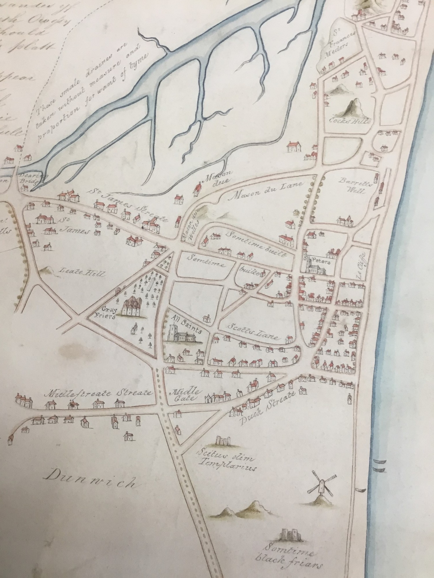
Hand-drawn plan of Dunwich (after Ralph Agas), 1580
Town streets, Middle Gate, churches including St Peter's and All Saints, friary grounds, shoreline and a windmill are shown.
1580 · Unknown author Unknown author · Wikimedia Commons
Public domain (plate dated 1580)
More cities to explore
 EnglandNorwichExplore it in 1490
 EnglandCambridgeExplore it in 1450 · 1660 · 1890
 EnglandLondonExplore it in AD 200 · 1390 · 1600 · 1885
 EnglandYorkExplore it in AD 300 · AD 950 · 1420 · 1800
Other lost towns of Europe: Ravenser Odd · Rungholt · Vineta · Ys · Kitezh.
Castles of Europe · Landmarks of Europe · create your own reconstruction.