Historic Cities · England
Cambridge through the ages
Cambridge is a city and non-metropolitan district in the county of Cambridgeshire, England. It is the county town of Cambridgeshire and is located on the River Cam, 55 miles (89 km) north of London. As of the 2021 United Kingdom census, the population of the City of Cambridge was 145,700; the population of the wider built-up area was 181,137.

Cambridge in 1450
Medieval Cambridge
This is Cambridge in the mid-15th century, a river market and a university town where Henry VI's King's College Chapel has risen only as walls and scaffolding. Walk from the fenlands into the tight streets, along the wharves of the Cam and past college gatehouses to a final view from the old castle mound.
The skyline is a ragged line of steep-tiled roofs, stone buttresses and timber gables, with the new vertical sweep of King's College Chapel rising in timber scaffolds. Streets are narrow, paved in worn cobbles, flanked by timber-framed houses, bakeries and workshops; the Cam carries low barges and pole-boats to hythes and mills. Gatehouses and college walls punctuate small green courts; fen mists often lie low over fields and the river at dawn.
The route: 22 streets, squares and views
Midsummer Common → Great Bridge → The Quays → Mill Lane → The Hythes → Petty Cury → Market Hill → Great St Mary's → The Old Schools → King's Gatehouse → …
Step inside, 12 interiors
Riverside Granary Loft · Grain Loft of the Mill · Bargewright's Workroom · Guildhall Court Hall · Scholars' Nave · Scholastic Lecture Chamber · Vaulted Choir Aisle · Old Court Chapel · Medieval College Hall · Scholars' Long Hall · Circular Nave · Priory Refectory
Planned from the Wikipedia record: Cambridge.
Cambridge in 1660
Newton's Cambridge
Cambridge in 1660 sits at an academic hinge: the colleges reassert their skyline after decades of national turmoil, scholars in gowns reoccupy courts, and the River Cam sorts the city into quads and quays. This walk passes the market and Hobson's Conduit, Trinity's Great Court and its fountain, the river-banks called the Backs, and the sites where a new college library by Christopher Wren will soon be raised.
Low stone and brick colleges, tiled roofs and clerestory windows pierce a sky of smoke and pale sun; King's College Chapel and the tower of Great St Mary's dominate, reflected in the slow River Cam. Narrow lanes open into cobbled courts and grassy quads, while wooden stalls crowd Market Hill and Hobson's Conduit throws bright water into troughs and fountains. The scale is collegiate and intimate: cloister walls, elm and willow by the river, and the distant profile of the town's motte and church towers.
The route: 22 streets, squares and views
Gog Magog Hills View → Trumpington Street Approach → Parker's Piece → Market Hill → Great St Mary's → King's Parade → King's College Chapel → The Backs → Clare Bridge and College → Trinity Great Court → …
Step inside, 12 interiors
Market Tavern · Nave of Great St Mary's · Old University Library · King's Choir · Clare College Hall · Great Hall · College Chapel · Alchemical Study · Riverside Warehouse · Magdalene College Hall · St John's Hall · King's Mill Interior
Planned from the Wikipedia record: Cambridge.
Cambridge in 1890
Victorian Cambridge
Cambridge in 1890 is a university city of stone chapels, college courts and a new scientific laboratory clustered along the River Cam, threaded by gas-lit streets, horse-drawn traffic and market stalls. This walk moves from the railway approach into the heart of the colleges, follows the river with punts and rowing eights, and visits the women's colleges at Newnham and Girton before finishing atop the old castle mound.
The skyline is an ensemble of medieval towers and nineteenth-century chimneys: the perpendicular buttresses and pinnacles of King's College Chapel, the spire of Our Lady and the English Martyrs, and squat red-brick college roofs and chimneys. Streets run narrow and cobbled with stone-fronted shops on King's Parade and gas lamps lining thoroughfares; the Cam glints with punts and eight-oared crews, its riverbanks edged by riverside lawns and willows. Scale is intimate, buildings close to the street, life visible at shopfronts and quays.
The route: 22 streets, squares and views
Cambridge Railway Station → Hills Road Approach → Trumpington Street → Fitzwilliam Museum Front → Downing Street Junction → Market Hill → Great St Mary's Church → King's Parade Shopfronts → King's College Exterior → The Backs by the Cam → …
Step inside, 13 interiors
Main Picture Gallery · Market Hall Interior · Nave and University Pulpit · Antiquarian Bookshop · Chapel Nave and Choir · Trinity Great Hall · Clare College Hall · Pepys Library · Newnham Common Room · Girton College Hall · Experimental Physics Hall · Apparatus Store and Workshop · Belfry Chamber
Planned from the Wikipedia record: Cambridge.
Its story
The story of Cambridge.
The Fort at Duroliponte and the Bridge on the Granta
The earliest clear evidence of occupation in the area is a 3,500-year-old farmstead found on the site of Fitzwilliam College, followed by an Iron Age settlement on Castle Hill from the 1st century BC, perhaps connected to the wider changes in south-eastern Britain linked to the arrival of the Belgae. Around AD 70 the Romans built a small fort, Duroliponte, on the same hill and converted it to civilian use about fifty years later; farmsteads and a village at Newnham show settlement spreading beyond it.
After the Roman withdrawal around 410 the place may have been abandoned by the Britons, though it is usually identified with Cair Grauth, one of the 28 cities of Britain listed in the History of the Britons attributed to Nennius. Anglo-Saxons had begun occupying the area by the end of that century, again on and around Castle Hill, in a settlement called Grantebrycge, the bridge over the Granta. It sat on the border between the East and Middle Anglian kingdoms and benefited from trade links across fenland that was otherwise hard to cross, although by the 7th century Bede could describe it as a "little ruined city", holding the burial place of Æthelthryth.
Danelaw Quayside, Norman Castle and the River Monopoly
The Anglo-Saxon Chronicle records Vikings arriving in 875, and by 878 the town lay under the Danelaw. Their vigorous trading grew it quickly, and its centre shifted from Castle Hill on the left bank of the river to the area now called Quayside on the right. With the return of Saxon power came churches such as St Bene't's, along with wharves, merchant houses and a mint whose coins carried the town's name abbreviated to "Grant". In 1068, two years after the Norman Conquest, William the Conqueror raised a castle on Castle Hill, the motte of which survives.
Henry I granted the first town charter between 1120 and 1131: it gave the town a monopoly of waterborne traffic and the hithe tolls, and recognised the borough court. A charter from King John in 1207 permitted the appointment of a mayor, the first recorded being Harvey FitzEustace in 1213. That river monopoly was the town's living. Goods came up the river from the agricultural country to the north-east and went on by road to London (2,000 firkins of butter every Monday, much of it from Norfolk), and the annual Stourbridge and Midsummer fairs drew merchants from across the country. An account of 1748 described the river as "often so full of [merchant boats] that the navigation thereof is stopped for some time".
Scholars from Oxford and the Expulsion of 1275
In 1209 students fleeing hostility at Oxford founded a university at Cambridge, and Peterhouse, the oldest college still in existence, followed in 1284. The town also held a significant Jewish community in the Middle Ages, centred on what is now All Saints Passage, then known as the Jewry, with a synagogue nearby. In January 1275 Eleanor of Provence expelled Jews from all of the towns within her dower lands, and the Jews of Cambridge were ordered to relocate to Norwich.
Plague, the Peasants' Revolt and the Charter of 1382
The Black Death reached the town in 1349. Few records survive, but 16 of the 40 scholars at King's Hall died, and the part of the town north of the river was almost wiped out. After a second national epidemic in 1361 a letter from the Bishop of Ely suggested that two Cambridge parishes be merged, there being too few people left to fill even one church. With more than a third of England's clergy dead, four new colleges (Gonville Hall, Trinity Hall, Corpus Christi and Clare) were founded over the following years to train replacements.
Cambridge took part in the Peasants' Revolt, and in 1382 a revised town charter brought a "diminution of the liberties that the community had enjoyed", transferring supervision of baking and brewing, of weights and measures, and of forestalling and regrating from the town to the university. Parliament met at Barnwell Priory in 1388. King's College Chapel was begun by Henry VI in 1446 and built in phases by a succession of kings, its history bound up with the Wars of the Roses, until its completion in the reign of Henry VIII.
Hobson's Conduit and Cromwell's Garrison, 1600s–1645
Repeated outbreaks of pestilence through the 16th century were answered in the early 1600s by Hobson's Conduit, which brought fresh water from Nine Wells, at the foot of the Gog Magog Hills, into the centre of the town. In the early part of the Civil War Cambridge was the headquarters of the Eastern Counties Association, which administered the regional East Anglian army that carried the Parliamentarian effort before the New Model Army was formed. Parliament gave control of the town in 1643 to Oliver Cromwell, who had been educated at Sidney Sussex College; the castle was fortified and garrisoned and some bridges destroyed to aid its defence. Royalist forces came within two miles in 1644, but the defences were never used and the garrison was stood down the following year.
Enclosure, the Railway and the Coprolite Diggings, 1801–1894
Inclosure acts of 1801 and 1807 allowed the town to spread over the surrounding open fields as it expanded through the 19th century, growth owed in part to longer life expectancy and improved agricultural production feeding trade in its markets. The railway arrived in 1845, after initial resistance, with the opening of the Great Eastern Railway's London to Norwich line; the university pressed for the station to be kept outside the town centre in order to restrict travel by undergraduates. Development followed around it in areas such as Romsey Town, and the London link drew heavier industry, brick, cement and malt. It also helped end the older trade, changing patterns of retail distribution and the railways together bringing down the town's importance as a market.
A layer of phosphatic nodules, or coprolites, beneath the local marl was mined in the 19th century for fertiliser and became a major industry in the county, its profits paying for buildings including the Corn Exchange, Fulbourn Hospital and St John's Chapel, until the Quarries Act 1894 and competition from America ended production. Improvement commissioners appointed in 1788 to maintain the streets were gradually given charge of sewers and public health before being abolished in 1889, their functions passing to the borough council. In 1848 members of the university drew up the first set of rules for association football, first played on Parker's Piece.
Wartime Headquarters, City Status in 1951 and Silicon Fen
In the Second World War the town was an important centre for the defence of the east coast, with an RAF training centre and the regional headquarters for seven counties. German raids were aimed mainly at the railway: 29 people were killed and no historic buildings were damaged. More than 7,000 people were evacuated to Cambridge from London, along with parts of the University of London, and in 1944 a secret meeting of military leaders at Trinity College laid the foundation for the allied invasion of Europe. Large council estates built between the 1930s and the 1980s expanded the city, above all north of the river at East Chesterton, King's Hedges and Arbury.
Cambridge was granted its city charter in 1951 in recognition of its history, administrative importance and economic success, despite having no cathedral, traditionally a prerequisite for city status, and lying instead within the Diocese of Ely. It gained a second university in 1992, when Anglia Polytechnic became Anglia Polytechnic University; renamed Anglia Ruskin in 2005, it grew out of the Cambridge School of Art opened by John Ruskin in 1858. The high-technology cluster around the city, known as Silicon Fen, rests on science parks often owned or leased by the colleges (Cambridge Science Park belongs to Trinity), and on companies spun out of the university. The city was also the home of Pye Ltd, founded in 1898 by W. G. Pye, who worked in the Cavendish Laboratory. The 2021 census recorded 145,700 people in the city and 181,137 in the wider built-up area, and Centre for Cities identified Cambridge as the UK's most unequal city in 2017 and 2018, with a Gini coefficient of 0.460 in 2018.
From the archive
Cambridge on paper: the old town as it was mapped.
A period plan or bird's-eye view of the old town, drawn between 1500 and 1850, the streets this page's reconstructions walk. Public domain, with its source named.
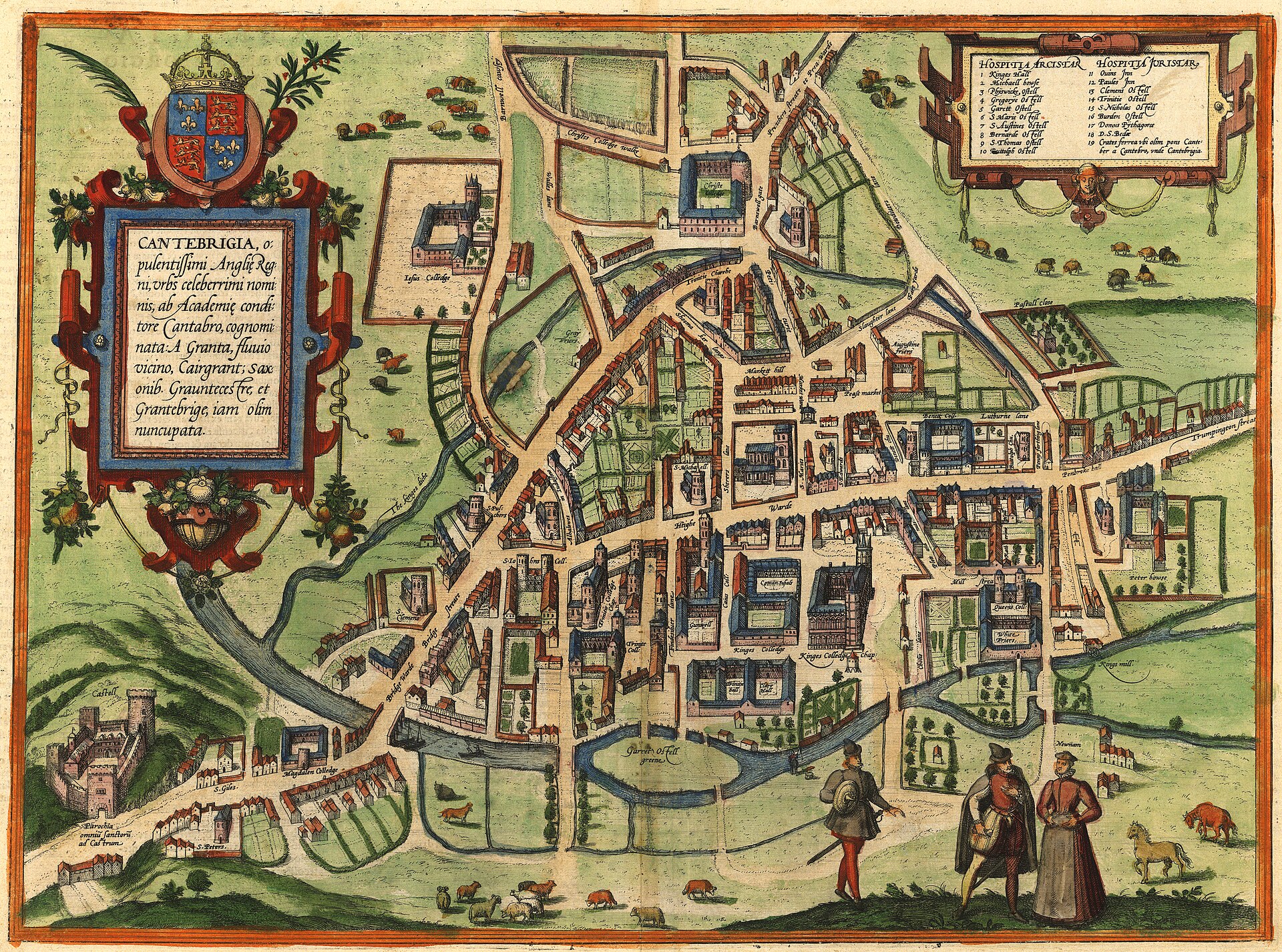
Bird's-eye view of Cambridge, from Braun & Hogenberg's Civitates Orbis Terrarum
Depicts Cambridge's town walls and gates, the River Cam, Market Hill, and collegiate courts including King's, Trinity and St John's, with named churches and streets.
1575 · Georg Braun · Wikimedia Commons
Public domain (plate dated 1575)
In this city
Landmarks of Cambridge, see each in its prime


Castles of Cambridge

More cities to explore
 EnglandLondonExplore it in AD 200 · 1390 · 1600 · 1885
 EnglandNorwichExplore it in 1490
 EnglandYorkExplore it in AD 300 · AD 950 · 1420 · 1800
 EnglandBathExplore it in AD 100 · 1500 · 1790
Castles of Europe · Landmarks of Europe · create your own reconstruction.