Historic Cities · England
Bath through the ages
Bath is a city in Somerset, England, known for and named after its Roman-built baths. At the 2021 census, the population was 94,080. Bath is in the valley of the River Avon, 97 miles (156 km) west of London and 11 miles (18 km) southeast of Bristol.

Bath in AD 100
Roman Aquae Sulis
This is Aquae Sulis at the height of its Roman use: a compact sacred complex built around a single hot spring and a temple to Sulis‑Minerva, drawing pilgrims, soldiers and traders. The walk follows the approach along the Fosse Way, moves through the temple and bath precinct, and climbs to a ridge that looks back over steaming roofs and the River Avon valley.
A low, riverined valley of compact Roman masonry and timber-roofed houses clustered around a single, steam-wreathed spring. Stone temples and barrel‑vaulted bathing halls rise above simple shopfronts and open stalls; narrow paved approaches funnel people to a colonnaded forecourt and the bubbling pool. Clay roofs, smoke from small furnaces and carts on the chalk Fosse Way give the town a compact, sunlit, slightly mineral haze.
The route: 20 streets, squares and views
Fosse Way at Avon Crossing → Walcot Military Post → Northern Road Settlement → Roadside Cemeteries → Processional Way to Temple → Temple Forecourt of Sulis → Temple Façade with Gorgon → Sacred Spring Outlet → Great Bath and Vaulted Hall → Bath Terrace and Poolside → …
Step inside, 12 interiors
Walcot Centurial Barrack · Cella of Sulis Minerva · Priests' Vestry and Offering Room · Sacred Spring Reservoir · Vaulted Great Bath Hall · Caldarium and Hypocaust Room · Bathing Portico and Cloakroom · Leatherworker's Tannery · Riverside Warehouse and Storehouse · Covered Market Hall · Herbalist's Workroom · Pottery Workshop and Kiln
Planned from the Wikipedia record: Aquae Sulis.
Bath in 1500
Monastic Bath
Bath stands as a compact medieval walled town centred on its Benedictine priory, with the abbey being rebuilt under royal patronage and the hot springs still serving the sick and pilgrims. The walk moves from the city's gates and market streets down to the Roman baths in the valley, passing timber‑gabled wool merchants, riverside workshops and the monastic precinct in a living, stone‑walled town.
Low, honey‑coloured Bath stone defines the skyline around a dominant abbey silhouette; narrow streets rise and fall from a deep river valley. Timber gables and jettied merchant houses crowd the lanes in dark oaks and painted woads, while roofs of thatch and tile glint in cool, often grey West Country light. The abbey’s new stonework and carved angels begin to puncture the skyline above battlemented walls and city gates.
The route: 21 streets, squares and views
Lansdown View → North Gate → Northgate Street → Upper Borough Walls → Wool Merchants' Row → High Street Market → Guildhall → St John's Lane → King's Bath Approach → Great Bath Terrace → …
Step inside, 13 interiors
North Gate Guardroom · Merchant's Hall · Covered Market Hall · Guildhall Great Chamber · Pilgrim Inn Hall · King's Bath Chamber · Great Bath House · Quay Warehouse · Nave under rising vaults · Monastic Chapter House · Refectory Hall · Monastic Infirmary · Walcot Parish Church
Planned from the Wikipedia record: Bath Abbey.
Bath in 1790
Georgian Bath
Bath in 1790 is a fully formed Georgian spa where honey‑coloured stone terraces, crescents and classical façades have reshaped the old Roman town into a city of fashion and water‑taking. This walk follows the arrival routes, the river crossings and the promenades of society to the Royal Crescent and the Circus, passing the Pump Room, Assembly Rooms and Pulteney Bridge along the way.
The city sits low in the Avon valley beneath limestone hills, its skyline a sweep of pale, honey‑coloured Bath stone: sweeping crescents, round classical façades, broken by the squat tower of the abbey and the low, arched span of Pulteney Bridge. Streets are relatively narrow and paved, riverbanks lined with quays and weirs. Coaches, sedan‑chairs and foot traffic animate the terraces and market streets; clothes and carriage liveries show bright silks and sober riding coats.
The route: 23 streets, squares and views
Beechen Cliff View → London Road Turnpike → Pulteney Bridge → Great Pulteney Street → Bathwick Meadows → The Parade Quay → Pulteney Terrace Approach → Abbey Churchyard → Roman Baths Exterior → Pump Room Forecourt → …
Step inside, 12 interiors
Bridge Merchant's Shop · Great Pulteney Morning Room · Riverside Coffeehouse · Minster Nave · Great Bath Chamber · Upper Pump Room Saloon · Octagon Ballroom · Milliner's Workroom · Playhouse Auditorium · Counting House · Townhouse Saloon · Crescent Drawing Room
Planned from the Wikipedia record: Bath, Somerset.
Its story
The story of Bath.
The Shrine at the Spring: Aquae Sulis
Everything at Bath begins with the hot water. Archaeological evidence suggests the main spring was treated as a shrine by the Britons before the Roman invasion, dedicated to the goddess Sulis, whom the Romans identified with Minerva. Her name survived the conquest and passed into the Roman town's name, Aquae Sulis, "the waters of Sulis". A temple was built in AD 60-70 and a bathing complex grew up over the following three centuries; engineers drove oak piles into the mud for a foundation and lined the spring chamber with lead, and in the 2nd century the spring was enclosed within a wooden barrel-vaulted structure housing hot, warm and cold baths.
What the spring meant to ordinary people is recorded in the curse tablets recovered from it: messages scratched onto metal in Latin, laying curses on personal enemies, so that a man whose clothes were stolen at the baths might write against the suspects and leave the tablet for the goddess to read. The town was given defensive walls, probably in the 3rd century. After the failure of Roman authority in the first decade of the 5th century the baths fell into disrepair and were eventually lost to rising water and silt.
Osric's Monastery and Alfred's Burh
The town was captured by the West Saxons in 577 after the Battle of Deorham. A monastery was founded here at an early date - reputedly by Saint David, though more probably in 675 by Osric, king of the Hwicce, perhaps using the walled area as its precinct; other accounts call Osric's foundation a nunnery and date it to 676. The ruined baths still worked on the imagination: the 9th-century historian Nennius wrote of a "Hot Lake" in the land of the Hwicce, walled in brick and stone, where men might bathe hot or cold as they chose, and Bede described them in near-identical terms. Offa of Mercia took control of the monastery in 781 and rebuilt the church, dedicating it to St Peter. According to the Victorian churchman Edward Churton, the Anglo-Saxon town was known as Acemannesceastre, 'aching men's city', from the reputation of the springs for healing the sick.
By the 9th century the Roman street grid had been lost and Bath was a royal possession. Alfred laid the town out afresh, leaving the south-eastern quadrant as the abbey precinct; the Burghal Hidage records Bath as a burh with walls of 1,375 yards and an allocation of 1,000 men for its defence. Under Edward the Elder coins were struck here to a Winchester design but marked BAD, for the Anglo-Saxon name Bathum, Bathan or Bathon, "at the baths", which is the source of the present one. In 973 Edgar was crowned king of England in Bath Abbey, in a ceremony that formed the basis of all later English coronations.
John of Tours Moves the Bishop's Seat, 1088-1295
The town was sacked during the Rebellion of 1088, after which William Rufus granted town, abbey and mint to a royal physician, John of Tours, Bishop of Wells and Abbot of Bath. Papal policy favoured bishops sitting in urban seats, and John translated his own from Wells to Bath, beginning a much larger church as his cathedral with a priory attached and the bishop's palace beside it, and building new baths around the three springs. Later bishops moved the seat back to Wells while keeping both names in the title of Bishop of Bath and Wells. Around 1180 Bishop Reginald Fitz Jocelin founded St John's Hospital beside the hot springs of the Cross Bath, for their health-giving properties and to shelter the poor infirm; it is among the oldest almshouses in England.
Administration ran through the hundreds, the Bath Foreign Hundred covering the area outside the city. Wealthy merchants had no standing in the hundred courts, so they formed guilds to gain influence and built the first guildhall, probably in the 13th century. The first mayor was appointed around 1200, and the mayoralty can be traced back to 1230. Bath has returned members to Parliament continuously since the Model Parliament of 1295.
Oliver King's Church, the Dissolution and the Civil War, 1500-1676
By the 15th century the abbey church was dilapidated, and in 1500 Oliver King, Bishop of Bath and Wells, decided to rebuild it on a smaller scale. It was finished only a few years before Henry VIII dissolved Bath Priory in 1539, and the church fell derelict before being restored as the parish church in the Elizabethan era, when Bath revived as a spa. The baths were improved, the aristocracy began to arrive, and a royal charter from Elizabeth I in 1590 confirmed city status. James Montagu, bishop from 1608, spent heavily on restoring the abbey and backed the baths themselves in the knowledge that the 'towne liveth wholly by them'. Anne of Denmark came to take the waters in 1613 and again in 1615; the Queen's Bath was named after her.
By the outbreak of the Civil War the city was a first-class resort, and in 1642 it lost much of that trade: the fiddlers, the "ladies who are there" and the ale-house guides lost their customers. Bath was garrisoned for Charles I and seven thousand pounds was spent on fortifications, but when parliamentary forces appeared the gates were thrown open and the city surrendered, becoming a significant post for William Waller's Western Association army. The royalists retook it in July 1643 after the Battle of Lansdowne and held it for two years until 1645. Unlike Bristol and Gloucester the city escaped widespread destruction, overcrowding, plague and starvation; billeted soldiers brought disorder and vandalism but not general plundering, and the markets and tradesmen stayed busy, though rents, grants and council spending all fell and the corporation's finances suffered.
The corporation's budget recovered quickly after the war. In 1668 Thomas Guidott, who had studied chemistry and medicine at Wadham College, Oxford, set up practice in the city; his 1676 book on the Bath waters brought their supposed curative properties to national attention, and the aristocracy came to partake of them.
Wood, Allen and Nash Build the Georgian Resort
The visitors needed housing, and the answer was speculative building on a scale that changed the city's trade for good. John Wood the Elder and his son laid out new quarters as streets and squares. Much of the Bath stone came from the Combe Down and Bathampton Down mines owned by Ralph Allen (1694-1764), who commissioned the elder Wood to build him a country house at Prior Park, between the city and his quarries, partly to advertise the stone. Allen also held the contract for the postal service in western England for more than forty years and served a term as mayor in 1742. Wood laid the foundation stone of the Circus on 18 May 1754 and died five days later. His son built the Royal Crescent between 1767 and 1774, designing only the curved facade: each purchaser bought a length of it and then hired his own architect to build a house behind. Robert Adam designed Pulteney Bridge around 1770, and Thomas Baldwin, made city surveyor and city architect in 1776, built the Pump Room, the Guildhall and Great Pulteney Street.
Much of this was commercial: in an age before the luxury hotel, apparently elegant residences were frequently purpose-built lodging houses where a visitor hired a room, a floor or a whole house and was waited on by the household's servants. The city acquired its first purpose-built theatre, the Old Orchard Street Theatre, early in the century, and the master of ceremonies Beau Nash drew up a code of behaviour for public entertainments and presided over the social round until his death in 1761. Jane Austen lived here with her parents and her sister Cassandra from 1801, at four addresses until 1806, and never liked the place - "It will be two years tomorrow since we left Bath for Clifton, with what happy feelings of escape" - though Northanger Abbey and Persuasion are set here. The population was 40,020 at the 1801 census, one of the largest in Britain, and in 1816 the place was described as "a seat of amusement and dissipation".
Canal, Railway and Crane Works, 1810-1939
The Kennet and Avon Canal connected the river to the Thames and London in 1810 by way of the Bath Locks. Bath Spa station opened on the Great Western Main Line in 1840 to Isambard Kingdom Brunel's design; Green Park station followed as the terminus of the Midland Railway from 1869 and of the Somerset and Dorset Joint Railway from 1874, and lost its passenger services in 1966.
Alongside the visitors the city carried an important manufacturing sector: crane and furniture making, printing, brass foundries, quarries, dye works, Plasticine manufacture and many mills, with Stothert & Pitt, Bath Cabinet Makers and Bath & Portland Stone among the significant firms. The Bath Tramways Company began running horse-drawn cars on 24 December 1880; that system closed in 1902 and was replaced in 1904 by an electric network on a wider gauge that eventually reached eighteen miles. Buses took over the first route in 1938 and the last tram ran on 6 May 1939.
The Baedeker Raids and the Rebuilt City, 1936-2021
Emperor Haile Selassie of Ethiopia spent four years of exile at Fairfield House in Bath, from 1936 to 1940. Between the evening of 25 April and the early morning of 27 April 1942 the city was hit by three air raids in reprisal for RAF raids on Lubeck and Rostock, part of the Luftwaffe campaign known as the Baedeker Blitz. More than 400 people were killed and more than 19,000 buildings were damaged or destroyed. Houses in the Royal Crescent, the Circus and the Paragon were burnt out along with the Assembly Rooms, and a 500-kilogram high-explosive bomb on the east side of Queen Square took 24 metres off the frontage of the Francis Hotel. The buildings have been restored, though signs of the bombing remain.
A postwar review of inadequate housing led to clearance and redevelopment in a style often at odds with the Georgian city, and in the 1950s the villages of Combe Down, Twerton and Weston were taken into Bath to allow new building, much of it council housing. The town planner Colin Buchanan's 1965 study proposed accommodating the motor car, including a traffic tunnel beneath the centre, and parts of it were implemented over conservationist objections. Redevelopment in the 1960s and early 1970s cost the city 18th- and 19th-century buildings until a popular campaign, strengthened by Adam Fergusson's book The Sack of Bath, largely halted it. During and after the Second World War the Ministry of Defence occupied three large sites on the outskirts; staff numbers fell after the Cold War, the remaining 2,600 were moved to Bristol between 2010 and 2013, and the sites were sold in 2013 for more than 1,000 houses.
UNESCO inscribed the city as a World Heritage Site in 1987. Thermae Bath Spa opened on 7 August 2006, three years later than planned. Bath had become part of the county of Avon in 1974 and, on its abolition in 1996, of the unitary district of Bath and North East Somerset; the ceremonial functions of the city, including its status and its mayoralty, passed to charter trustees. In 2021 it was inscribed a second time, as part of a group of spa towns across Europe listed as the Great Spas of Europe. The built-up area had a population of 94,080 at the 2021 census.
From the archive
Bath on paper: the old town as it was mapped.
A period plan or bird's-eye view of the old town, drawn between 1500 and 1850, the streets this page's reconstructions walk. Public domain, with its source named.
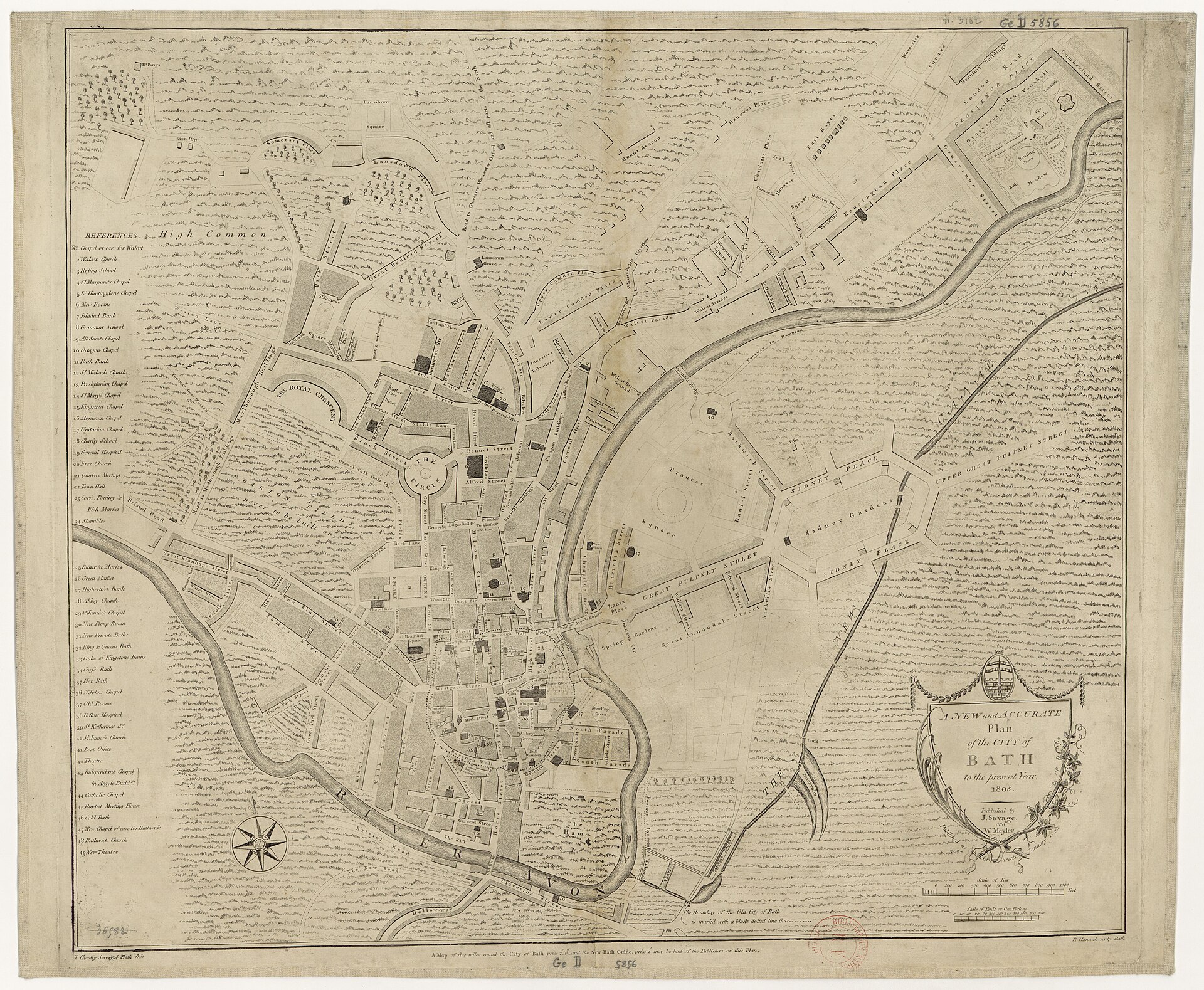
A New and Accurate Plan of the City of Bath, to the present year 1805
Shows Bath's street plan with the River Avon, The Circus, Royal Crescent area, Great Pulteney Street, Sidney Gardens and numbered public buildings.
1805 · Wikimedia Commons
Public domain (plate dated 1805)


Castles of Bath


More cities to explore
 EnglandBristolExplore it in 1497 · 1850
 WalesCardiffExplore it in 1300 · 1910
 EnglandLondonExplore it in AD 200 · 1390 · 1600 · 1885
 EnglandYorkExplore it in AD 300 · AD 950 · 1420 · 1800
Castles of Europe · Landmarks of Europe · create your own reconstruction.