Historic Cities · Germany
Vineta through the ages
Vineta is the name of a legendary city at the southern coast of the Baltic Sea. The legend evolved around traditions about the Medieval emporium called Jumne, Jomsborg, Julin or similar names by the chronicles, and with which Vineta is sometimes identified.
Vineta in 1100
The Baltic Emporium
This is Jumne at the height of its life as a major Baltic emporium, the multiethnic trading place chroniclers later named Vineta. The walk follows the river mouth and timber quays into the market and workshops, finishing on the high ground that overlooks the town and its many masts.
Low wooden skylines built on piles and bundled wharves run along a shallow estuary; masts and furled square sails crowd the water while ochre and tar streak hulls. Gate towers and palisades display painted shields; market stalls spill cloth, furs and strings of amber into muddy streets. Narrow earthen lanes thread between thatch and plank shops, smiths’ smoke and the steady creak of ship timbers under a cool Baltic light.
The route: 9 streets, squares and views
Dievenow Estuary → Dievenow Quay → Timber Wharves → Harbour Gate → Jumne Market → Amber and Fur Row → Boatyards' Quay → Mühlenberg (Mill Hill) → Silberberg (Silver Hill)
Step inside, 5 interiors
Longship Alehouse · Harbour Warehouse · Hall of Amber and Furs · Shipwright's Loft · Hall of the Silver Merchants
Planned from the Wikipedia record: Vineta.
Its story
The story of Vineta.
A Legend Grown Around Jumne, Julin and Jomsborg
Vineta, sometimes Wineta, is the name of a legendary city on the southern coast of the Baltic, on the Pomeranian shore. It is recorded as a fictional city and a mythical location rather than a place with a documented civic history. The historical core of the story probably goes back to traditions about the high-medieval early town that the chronicles call Jumne, Jomsborg, Julin or names like them, and with which Vineta is sometimes identified.
The chroniclers who transmitted the name did not agree about what it referred to. Adam of Bremen is cited by the later Vineta-hunters as having Vineta washed by three seas and reachable from Demmin by a short row, two statements they spent a great deal of effort trying to fit to real water. Thomas Kantzow, writing his Pomeranian chronicle in the first half of the sixteenth century, treated Vineta and Wollin as separate places, remarking that Wollin was already a powerful town when the Danish king Harald Bluetooth is said to have died at Vineta. Johann Micraelius listed Wineta with Julin, Arkona and Carentz among towns once fine and powerful and since ruined, and Adam Greschovius, writing in 1670, cited Adam of Bremen for the claim that Julin became the largest town in Europe after the fall of Vineta.
The Warning Nobody Heeded
There are several Vineta legends, and all of them portray the townspeople as living in an excessive, voluptuous or blasphemous way and then being punished by a flood that took the city to the bottom of the Baltic; the cause is given as the moral decay of the town, the pride and extravagance of its inhabitants. In one of the many variants the destruction was announced in advance. Three months, three weeks and three days beforehand the city is said to have appeared above the sea with all its houses, towers and walls as a coloured shape of light, at which the elders advised everyone to leave, since to see towns, ships or people doubled always means destruction. The inhabitants, in their want of humility, took no notice, and none was taken either of the last warning, when a water-woman is said to have risen from the sea close before the town some weeks later and called out three times in a high and dreadful voice.
In some versions the city, or parts of it, reappears on certain days or can be seen from a boat, which makes the warning the story carries more tangible for its audience; in others the bells are still to be heard from the depths of the sea at particular times.
The Reef off Koserow and the Maps That Copied One Another
Several variants place Vineta off Koserow on the island of Usedom, and the search for it followed them. In the sixteenth century David Chyträus, in his Chronicon Saxoniae, put Vineta beyond the river Peene near the village of Damerow, an outlying farm of Koserow; for him Usedom was the land of the Vinetans while Julin, on neighbouring Wolin, was inhabited by Pomeranians. The historian Wilhelm Ferdinand Gadebusch of Swinemünde looked to the same stretch of coast in 1863, arguing that a Vineta set inland on the shallow Dievenow, a mouth-arm of the Oder, could not have been reached by larger ships and that the deep-water port such a town needed must lie elsewhere. The many large stones on the Koserow reef were long treated as evidence, and several scholars who inspected them claimed to see ordered formations that might have been moles; after 1818, when the stones were lifted from the reef in quantity to build the moles at Swinemünde, it was clear that they were of natural ice-age origin and bore no working marks. No traces of Slavic settlement have been found in north-west Usedom, and the thesis is no longer accepted.
A good dozen maps published between 1633 and 1700 place the sunken Wineta just east of the island of Ruden, off the mouth of the Peene, and the theologian Bernhard Walther Marperger reported it in the same spot around 1700. The number of maps proves little, since maps of that period were largely copied one from another. The idea most likely originates in the All Saints' flood, dated 1304 or 1306, which took most of Ruden and the land that had until then joined it to Mönchgut on Rügen. The stretch between Ruden and the Peenemünder Haken was considered again after a Viking gold find there in 1905 or 1908, then dropped for want of any further indication.
The Meteor at the Arkona Reef, 1937–38
In 1937 and 1938 the Arkona reef was investigated as part of the National Socialists' Germanic and Viking research. Two things prompted it: the Lubin map, which recorded that a town was supposed to have sunk off Cape Arkona, and a coin in a Hamburg museum, the so-called Dithmarschen gold bracteate, on which a harbour plan was said to be visible and to represent Jomsburg or Vineta. The research ship Meteor of the Reichsmarine carried out surveys, aerial photography, diving and salvage work at the reef. The crew brought up stone moles, boundary ramparts and individual objects including four stone balls from siege engines and a runestone bearing the name Ulf, which was also said to be legible on the gold coin. Taken together with the Jaromarsburg, this was read as evidence that Jomsburg or Vineta had stood there.
"Vineta ist Wollin!": Digging on the Dievenow
Rudolf Virchow's verdict was blunt: "Vineta is Wollin!" Systematic work on the question had begun earlier, with Steffen's mapping in 1828 and Robert Klempin's study of 1847, which weighed the written testimony against the topographical and geological possibilities and concluded that Wollin was the only possible site. In 1868 the regional historian Heinrich Berghaus pointed to the Arabic and other foreign coins then being turned up at Wollin and around it. Virchow dug at the Galgenberg outside the town in 1872, when nearly a hundred almost untouched barrows still stood there. In 1897 Adolf Stubenrauch, prehistorian and restorer at the Stettin museum, toured every site that had ever been proposed and then dug at Wollin, finding beneath a later Swedish redoubt on the Silberberg a Slavic rampart and its settlement, and large quantities of household gear, sherds and tools of the Slavic and Viking period. His conclusion was that the only place where a search for Vineta could be conducted in a way useful to scholarship was the neighbourhood of the town of Wollin.
Adolf Hofmeister formulated the thesis in 1931 and 1932 that Vineta, Jumne, Julin and Jomsborg were all different spellings for the same place, on the site of the present town of Wolin; it is the only mainstream thesis on Vineta's location in current historiography. Excavation followed. From 1934 to 1938, under Karl August Wilde, digging along the Dievenow bank uncovered timber landing stages almost the whole way, with warehouses, dwellings and craftsmen's booths behind them, well-preserved piling and thousands of finds. On the market place the work went down six metres through several layers of timber buildings, separated by heavy burnt layers that were attributed to the destructions by the Danes recorded in the written history and that allowed the sequence to be dated; after each burning the site had been levelled and built over again. Further work was prevented by the war.
From 1952 Władysław Filipowiak of the Stettin museum led extensive excavations in the old town of Wolin, made possible because the ground between the church and the Dievenow had been destroyed in the war and largely not rebuilt. Earlier results were confirmed and extended with more than 50,000 finds, now held in the town museum beside the town hall, and the Silberberg and the Galgenberg cemetery were declared archaeological reserves. What the work established was an early-urban trading settlement some 4.5 kilometres long and up to 800 metres wide, with cemeteries at either end, occupied as a significant sea-trading place with a correspondingly large multi-ethnic population from the tenth to the twelfth century. The coins make the reach of its trade plain (Byzantine, Arab, German and Wendish pieces), and the flight of the people of Wollin from the Danish invasions to Kammin is documented by a hoard of 140 to 150 Arab coins. Around the other candidate sites, Barth in particular, coin finds of this kind are entirely absent.
Barth's Patented Title and the Peenestrom Proposal
A thesis placing Vineta near Barth was published as early as 1933. Independently of it, Klaus Goldmann and Günter Wermusch worked on the question from 1994 and went public in 1999, arguing that the Oder once ran to the Baltic through a mouth-arm that no longer exists, emptying into the Saaler Bodden, which would explain why the position given in the old writings, Vineta at the mouth of the Oder, does not match the geography of today. Several scholars, among them Joachim Herrmann, Wilfried Menghin and Friedrich Lüth, called the work a promising theory or a well-supported approach. The Barth local museum was renamed the Vineta-Museum and the town patented the designation Vineta town. As at 2016 no targeted archaeological investigation had been carried out in the Barth area, so the material case rested on differing interpretations of chance finds, and the thesis remained disputed among some scholars. Against it is the course of the water itself: the drainage ran west during the Pomeranian stage of the ice age but had turned east by 8000 BC at the latest, after which the glacial valley silted up and turned to peat.
From 2001 the regional planner Dietrich Schumacher proposed in a series of local-history articles that Vineta lay on the ground between the Dänische Wiek and the Peenestrom, bounded to the south by the Ziesebruch, which he holds to have been flooded and in places more than a hundred metres wide; those three waters, on his reading, are the three seas Adam of Bremen described.
Müller's Poem, Brahms's Chorus and the Zinnowitz Festival
The legend has been worked and reworked since the Romantic period. Wilhelm Müller's poem Vineta appeared in 1825 in his cycle Muscheln von der Insel Rügen and was set by Johannes Brahms for six-part unaccompanied choir, op. 42 no. 2, in 1860; Hugo Kaun made a symphonic poem of it in 1888. Heinrich Heine's Seegespenst, published in 1826 in the cycle Die Nordsee, belongs to the same current, and Theodor Fontane alludes to Heine's poem in the seventeenth chapter of Effi Briest in 1895. Selma Lagerlöf retold the legend in Nils Holgersson in 1906–07, and the story has carried a long line of operas, from Heinrich Frankenberger's Wineta at Sondershausen in 1851 to Feliks Nowowiejski's Legenda Bałtyku, first staged at Poznań in 1924 and given in German as Vineta at Rostock on 19 June 1959.
Since 1997 the Vorpommersche Landesbühne of Anklam has staged the Vineta-Festspiele in the open air at Zinnowitz on Usedom.
From the archive
Vineta on paper: the place as it was mapped.
A period map that sets the place down, drawn between 1500 and 1850, the ground this page's reconstructions walk. Public domain, with its source named.
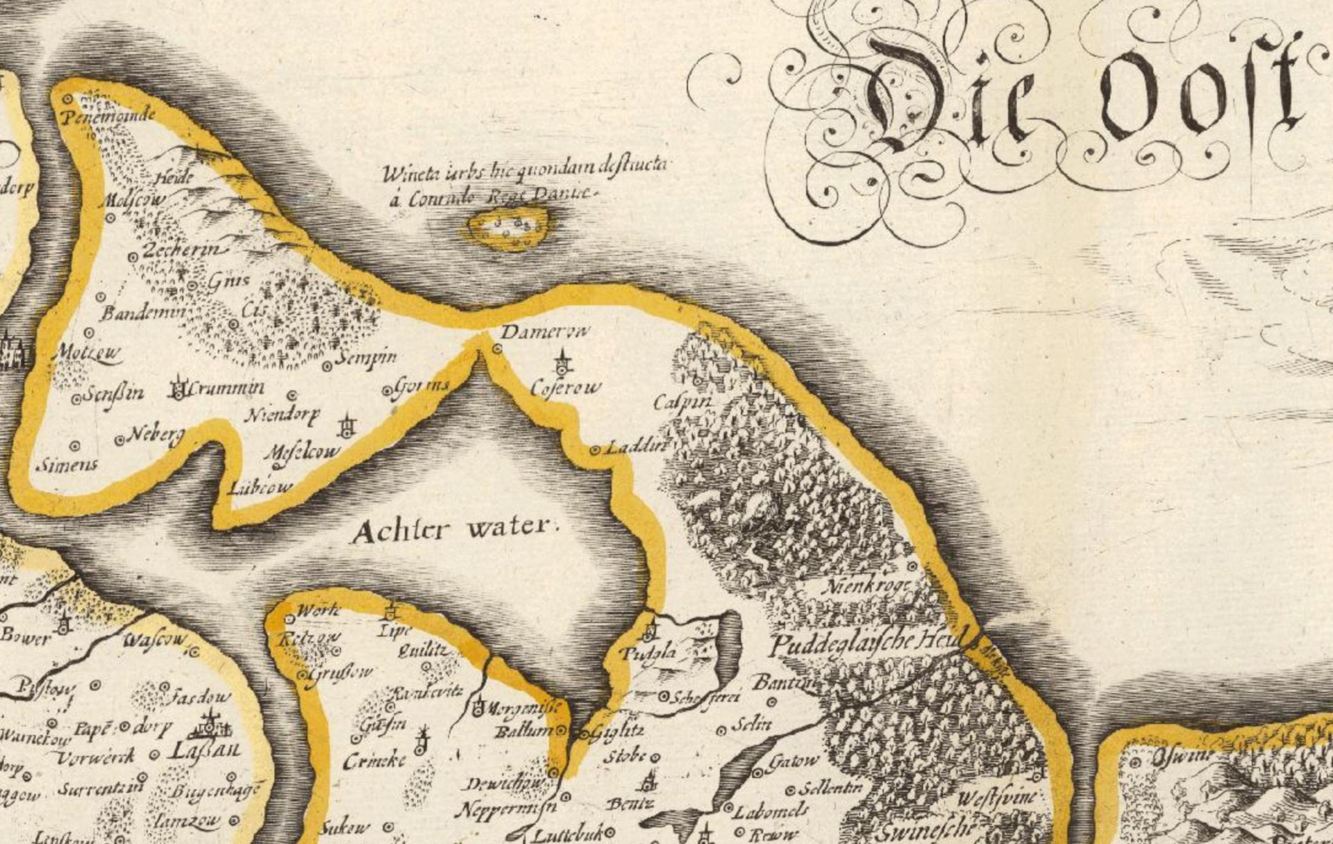
Wineta on Eilhard Lubinus's Great Map of the Duchy of Pomerania
The legend beside the ruined islet reads Wineta: urbs hic quondam destructa à Conrado Rege Daniae — the city here once destroyed by Conrad, King of Denmark — off Peenemünde in the Achterwasser.
1618 · Eilhard Lubinus · Wikimedia Commons
CC0 (plate dated 1618)
More cities to explore
 GermanyBerlinExplore it in 1750 · 1871 · 1928
 DenmarkCopenhagenExplore it in 1650 · 1840 · 1900
 GermanyMunichExplore it in 1500 · 1700 · 1900
 GermanyCologneExplore it in AD 150 · 1250 · 1880
Other lost towns of Europe: Dunwich · Ravenser Odd · Rungholt · Ys · Kitezh.
Castles of Europe · Landmarks of Europe · create your own reconstruction.