Historic Cities · Greece
Helike through the ages
Helike was an ancient Greek polis or city-state that was submerged by a tsunami in the winter of 373 BC.

Helike in 373 BC
The City of Poseidon
Helike stands as the leading city of the Achaean League on the Gulf of Corinth in the last winter before the earthquake and wave of 373 BC. The walk threads the harbour, the busy agora and its stoas, the poplar grove and the famed sanctuary of Helikonian Poseidon across the low coastal plain beneath Mount Kerynites.
A compact coastal polis of pale limestone walls and low stone houses roofed in red-baked clay tiles, Helike clusters around a broad agora and a busy harbour on a shallow lagoon and the Gulf of Corinth. Colonnaded stoas edge sun-faded market-ways, bronze gleams at the sanctuary of Poseidon, and wind-stiff poplars and reedbeds mark the marshy edge where rivers meet sea; streets are chiefly narrow and cobbled, crowded with traders, fishermen and votive traffic.
The route: 9 streets, squares and views
Coastal Plain under Mount Kerynites → Selinountas River Mouth → Harbour of Helike → Outer Quay → Agora of Helike → Stoa of the Agora → Road to Boura → Poplar Grove → Sanctuary of Helikonian Poseidon
Step inside, 5 interiors
House with Inner Courtyard · Shipwright's Workshop · Tholos Council Chamber · Stoa Colonnade Hall · Cella of Helikonian Poseidon
Planned from the Wikipedia record: Helike.
Its story
The story of Helike.
Ion's City and the Achaean Twelve
The city was said to take its name from Helike, daughter of Selinous and wife of Ion; Ion inherited the district from his father-in-law, founded the city and named it after his wife. The oldest artefacts recovered from the ruins are of the Early Bronze Age, roughly 3000–2200 BC, and excavation has reached a proto-urban town of that date with large rectilinear buildings and cobbled streets, along with walls and occupation layers rich in pottery of the Mycenaean period, about 1750–1050 BC. Homer's Iliad names Helike among the cities that sent men to the Trojan War with Agamemnon's forces.
After the Dorian arrival in Aigialeia the Ionian inhabitants of Helike were displaced and settled in Attica, and the Achaeans took the district, building twelve cities on the same ground the Ionians had held. Tisamenos came with Lacedaemonians driven out of Laconia and Argos, and they were permitted to settle in the city, but the arrangement did not last, the two sides fell to war and the Achaeans won. Helike went on to lead the Achaean League, the association that joined twelve neighbouring cities in the area around what is now Aigio, and was also known as Dodekapolis, from the Greek words for twelve and city. It struck its own coinage. The finds from the ancient city amount to two fifth-century copper coins, now in the Bode Museum in Berlin, carrying the head of Poseidon on the obverse and his trident on the reverse.
The Sanctuary of Helikonian Poseidon
Poseidon was the city's patron, and a temple stood there dedicated to Helikonian Poseidon; Pausanias records a great temple and a statue of the sea god on more than human scale. Two of the excavated buildings held religious artefacts dating back as far as 850 BC, which suggests they had once been temples, possibly to Poseidon. Greeks travelled to Helike to be blessed by the god and to trade, and its panhellenic temple and sanctuary were known throughout the classical world, reckoned second only to Delphi in religious importance. Helike founded colonies of its own, among them Priene in Asia Minor and Sybaris in southern Italy.
The Winter Night of 373 BC
The ancient account puts the destruction of Helike in 373 BC, two years before the battle of Leuctra, on a winter night. Several things were read afterwards as warnings: immense columns of flame appeared, and five days beforehand every animal and vermin left the city, moving towards Keryneia. The city and a space of twelve stadia below it sank into the earth and the sea covered them. All the inhabitants died without a trace, and nothing of the city remained in view but a few building fragments projecting from the water. Spartan ships lying at anchor in the harbour were dragged down with it. Two thousand men sent by the Achaeans failed to recover a single body. The territory was divided among the neighbours, and Aigion took possession of its land.
Strabo recounts a tsunami triggered by an earthquake, and gives the cause as the anger of Poseidon. Ionians driven out of Helike had sent to ask the inhabitants for the statue of Poseidon, or failing that for the model of the temple; the inhabitants refused both, and refused again after the general council of the Achaeans voted in the Ionians' favour. The submersion followed that winter, and the Achaeans afterwards gave the Ionians the model. Some authorities held that the people of Helike and Bura had murdered the Ionian deputies outright. An account by Seneca has the sea destroying the city after the appearance of a comet. Modern research attributes the catastrophe to an earthquake and the tsunami that accompanied it.
Eratosthenes, Pausanias and a Site Lost to Memory
About 150 years after the disaster the philosopher Eratosthenes visited the place and reported that a bronze Poseidon still stood upright beneath the water, holding a hippocamp in one hand, where the ferrymen said it endangered those who fished with nets. He put it in a poros, a word whose meaning in ancient Greek is not fully clear; it may denote an inland lagoon, a lake or a narrow strait. Most archaeologists took it to mean the Gulf of Corinth. Around AD 174 the traveller Pausanias visited a coastal site still called Helike, seven kilometres south-east of Aigio, and reported that the walls of the ancient city could still be seen underwater, "but not so plainly now as they were once, because they are corroded by the salt water".
For centuries afterwards Roman visitors sailed over the ruins to admire the statuary, until the site silted over and its location passed out of memory. The Greeks Strabo, Pausanias and Diodorus of Sicily and the Romans Aelian and Ovid are among the ancient writers who described the place. Adalberto Giovannini argued that the submergence of Helike may have given Plato the ending of his story of Atlantis.
The Same Coast in 1817
In 1817 an earthquake followed by a tsunami struck the same spot. The shock was preceded by a sudden explosion like a battery of cannon, and the aftershock was said to have lasted a minute and a half, during which the sea rose at the mouth of the Selinous and covered all the ground immediately below Aigio. When the water withdrew, the beach had been carried away completely and no trace was left of the artillery depots that had stood on the shore. Sixty-five people died in Aigio, two-thirds of its buildings were entirely ruined, and five villages in the plain were destroyed with them.
A Century and a Half of Searching, 1826–1979
The buried town became a standing problem for underwater archaeology, and opinion was divided on where it lay. The French diplomat and archaeologist François Pouqueville treated it in his Voyage en Grèce of 1826; Ernst Curtius speculated about the location in 1851; J. F. Julius Schmidt, director of the Athens Observatory, published a study in 1879 comparing the Aigio earthquake of 1861 with the one that might have destroyed Helike; Spiros Panagiotopoulos, mayor of Aigio, wrote on the ancient city in 1883, and P. K. Ksinopoulos in 1912. Stanley Casson addressed the problem in 1939, and after him Georg Karo in 1948, Robert Demangel and Alfred Philippson in 1950, Spiros Dontas in 1952, Aristos Stauropoulos in 1954, N. K. Moutsopoulos in 1956, George K. Georgalas in 1962, and in 1967 both Nikos Papahatzis and the archaeologist Spyros Marinatos, who said that only the declaration of a third world war would obscure the discovery of Helike.
In 1967 Harold Eugene Edgerton worked with the American researcher Peter Throckmorton, both convinced the city lay on the seabed of the Gulf of Corinth. Edgerton perfected sonar equipment for the search, but the Greek authorities refused permission. Jacques Cousteau searched in 1967 and again in 1976 without result. In 1979 the Greek undersea explorer Alexis Papadopoulos found a sunken town in the Corinthian Gulf at a depth of between 25 and 45 metres, filming walls, fallen roofs, roof tiles and streets; whether it could be identified with Helike, the Greek journal Archaeology noted, was a question for extensive underwater research, though the find was in any case an interesting one.
The Helike Project and the Lagoon at Rizomylos
The Greek archaeologist Dora Katsonopoulou, president of the Helike Society, and Steven Soter of the American Museum of Natural History launched the Helike Project in 1988 to find the city. Against the general reading of poros as the Gulf of Corinth, they raised the possibility that it meant an inland lagoon: an earthquake causing soil liquefaction on a large scale would have carried the city down below sea level, and coastline collapsing into the sea would have raised a tsunami that flooded the lagoon over it, after which river sediment coming down from the mountains would have filled the lagoon in and hidden the remains under solid ground. Work began in the delta of the Selinous and the Kerynites. A magnetometer survey of the midplain in 1994, carried out with the University of Patras, showed the outline of a buried building; excavation of that target, now called the Klonis site, produced a large Roman building with standing walls and a well-preserved Early Bronze Age settlement.
In 2001 Helike was rediscovered buried in an ancient lagoon near the village of Rizomylos. Excavation to 2005 exposed the Classical and Hellenistic city, a Roman road and Roman and Byzantine cemeteries, and in 2012 the earthquake destruction layer itself was uncovered: cobblestones, clay roof tiles and pottery, matching the ancient texts both on the location and on the effects of the earthquake. Digging continues in the Helike delta each summer, with finds running from the prehistoric period through the city's revival in Hellenistic and Roman times. To protect the site from destruction the World Monuments Fund placed Helike on its lists of the 100 most endangered sites in 2004 and again in 2006.
Research published in May 2025 combined archaeological and geological data into a seismic history of the Helike Fault covering nearly three millennia, identifying earthquakes not previously known and establishing that major disasters occurred roughly every 300 years between Geometric and Roman times. What the timeline shows is repeated return: the inhabitants resettled a catastrophe-prone ground again and again, shifting where they built and how they built to suit a landscape that kept changing under them. The site lies in the municipality of Aigialeia and is designated an archaeological site.
From the archive
Helike on paper: the place as it was mapped.
A period map that sets the place down, drawn between 1500 and 1850, the ground this page's reconstructions walk. Public domain, with its source named.
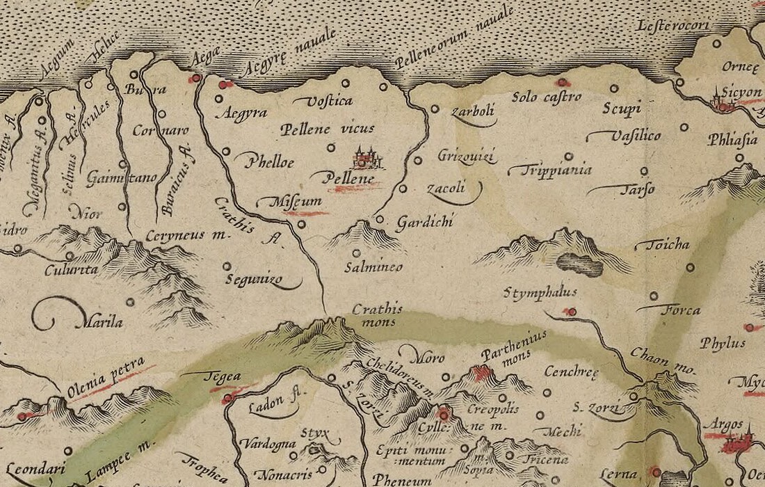
Helice on Mercator's Morea olim Peloponnesus
Mercator marks Helice and neighbouring Bura on the Achaean shore of the Gulf of Lepanto, the two cities an earthquake and wave took into the sea in a single night in 373 BC.
1589 · Gerard Mercator · Wikimedia Commons
Public domain (plate dated 1589)
More cities to explore
 GreeceAthensExplore it in 430 BC · AD 130 · 1835
 GreeceMonemvasiaExplore it in 1300
 GreeceThessalonikiExplore it in 1200 · 1900
 GreeceAtlantisExplore it in 9600 BC
Castles of Europe · Landmarks of Europe · create your own reconstruction.