Historic Cities · Greece
Monemvasia through the ages
Monemvasia is a town and municipality in Laconia, Greece. The town is located in mainland Greece on a tied island off the east coast of the Peloponnese, surrounded by the Myrtoan Sea. Monemvasia is connected to the rest of the mainland by a tombolo 400 metres (1,300 ft) in length.

Monemvasia in 1300
The Malmsey Rock
This is Monemvasia at the height of its Byzantine prosperity, when malmsey wine leaves the rock for courts across Europe and galleys ride its harbours. The walk follows the single approach across the tombolo, threads the lower town’s vaulted lanes and markets, climbs to the plateau with Hagia Sophia on the cliff lip, and ends where the sea and the vineyards meet the sky.
A single jagged limestone rock rises from the Myrtoan Sea, connected to the mainland by a narrow tombolo and defended by a single gate. Whitewashed and rubble-built houses cling in stacked tiers behind compact sea walls; red clay tiles and domed church roofs puncture the skyline. Narrow paved alleys, barrel-vaulted workshops and stone cisterns crowd the lower town, while threshing floors and a domed metropolitan church crown the flat upper plateau. Dark-hulled galleys and round cargo ships stand off the piers, their sails and oars ready.
The route: 9 streets, squares and views
Tombolo Causeway → Single Gate → Lower Town Harbour → Vaulted Lanes → Elkomenos Square → Plateau Cisterns → Hagia Sophia → Archon's Hall → Cliff-top Vantage
Step inside, 5 interiors
Malmsey Wine Vault · Nave of Christos Elkomenos · Dome Above the Sea · Stone Audience Chamber · Cliffside Chapel
Planned from the Wikipedia record: Monemvasia.
Its story
The story of Monemvasia.
Akra Minoa and the Founding from Sparta
The name comes from two Greek words, moni, single, and emvasis, approach: the town of the single entrance, reached from the mainland only along a tombolo four hundred metres long. Its Italian form, Malvasia, would travel further than the town did. Pausanias called the rock Akra Minoa, the Minoan promontory, and Strabo a century earlier a Minoan fortress; the name points to a port in antiquity, traces of which have been found underwater, though whether any substantial settlement stood on the island is not known. Epidaurus Limera, a little to the north, was abandoned in the fourth century, about when the imperial capital moved to Constantinople and the sea routes shifted with it.
Monemvasia was founded in the sixth century by the relocation of the inhabitants of ancient Sparta, then called Lacedaemon, which had gone on being lived in through earthquakes, the Gothic raids of 395 under Alaric I, the Vandals under Gaiseric in 468 and the plague of 541–543. The later Chronicle of Monemvasia puts the move down to panic after a Slav raid in the reign of Maurice in 587–588, part of the population fortifying itself on the rock under its bishop. The archaeology does not support that: the first level of the basilica of Christ Elkomenos in the lower town dates from Justinian's reign, some decades earlier.
Sparta was judged too weakly fortified and too far from its harbour to survive a long blockade, and with the capital now at Constantinople ships from Gytheion had to round Cape Maleas. Its people were moved to the rock and south-eastern Laconia reorganised, families planted in the passes of Parnon; the Chronicle says some went as far as Sicily.
A Port on the Sicily Route, 8th–12th Centuries
Where other settlements in the Peloponnese declined from the seventh century onwards, Monemvasia grew into a commercial and cultural centre on the sea lanes, among them the route to Sicily; a bronze coin of Philippikos Bardanes struck in Sicily was found in the lower town. The oldest known mention of the place dates from the third decade of the eighth century, by the pilgrim Vilibaldos, who broke a voyage from Sicily to the Holy Land there; Theophanes the Confessor names it in his account of the plague reaching Byzantium in 746–747. That same position made it a target: Arab raids began in the ninth century and multiplied after the Arab settlement of Crete.
At the beginning of the tenth century the town's ecclesiastical seat passed from the jurisdiction of Rome to the patriarchate of Constantinople and was demoted under the diocese of Corinth, but Monemvasia kept many privileges, self-government among them, and went on growing. The eleventh and twelfth centuries brought real wealth: settlement spread around the island from the landward side and the churches of Hagia Sophia and Elkomenos Christos were rebuilt. By the time of the Komnenoi the town guarded the western entrance to the Aegean, and in 1147 ships of the Sicilian king Roger II tried to take it and were driven off with heavy losses.
Franks, Nicaea and the Golden Age to 1460
The Latin Empire besieged Monemvasia without success in 1222, and in 1225, after a three-year siege, the Frankish prince of Achaia, William of Villehardouin, took it. Those unwilling to live under Latin rule left for Bithynia, which was granted much the same commercial privileges the town had held; Monemvasia kept its own, took on an obligation to maintain ships, and became the seat of a Latin bishop. The loss wrecked the plans of Michael VIII Palaiologos, emperor of Nicaea, for recovering the lands that had fallen to the Franks, so when William was captured at Pelagonia in 1259 he was held until 1262, when he agreed to surrender the castles of Monemvasia, Mystras, Grand Magne and Geraki. The town became the seat of a Byzantine general and of an Orthodox metropolitan, and Andronikos III Palaiologos went on to exempt it from twenty-eight taxes outright.
What followed, down to 1460, is reckoned the town's golden age: population, trade and shipping rose, and with them ecclesiastical life. In 1324, of 3,108 pyres contributed to the Patriarchate of Constantinople by the metropolitans, 800 came from Monemvasia, more than from any other; in 1347 or 1348 John VI Kantakouzenos raised the metropolis into the hierarchy of the Patriarchate of Jerusalem. Wealth also drew attack: Roger of Lauria sacked the lower town in 1292.
A succession dispute ended the quiet. Theodore Palaiologos, named to succeed Manuel Kantakouzenos in the Despotate of the Morea, was driven off by a rebellion in the town and went to Venetian-held Koroni to ask for help in exchange for Monemvasia's territory; captured by the Ottoman sultan Bayezid I in 1394, he offered the town's surrender for his own release, then escaped and retook it from the Ottomans in July 1394 with Venetian help. The disorder cost the town people and halted its commercial traffic. After the fall of Constantinople in 1453 the despots Thomas and Demetrios Palaiologos fell out over the Despotate's future; Demetrios surrendered Monemvasia to Mehmed II in May 1460, though the sultan withdrew without besieging it, and on 12 September 1460, on Thomas's advice, the inhabitants offered the town to Pope Pius II, who accepted.
Venice, Malmsey and the Treaty of 1540
Mehmed II took Laconia and the fortresses of Achaia and Ilia in 1460, and with the surrender of Salmenikos in July 1461 the conquest was complete but for Venice's Peloponnesian possessions and Monemvasia. By the end of 1463 the town had passed wholly to the Venetians. The war of 1463–1479 left part of its territory in Ottoman hands, which hurt its farming and trade, and Venice's holdings around it shrank again after the war of 1499–1503.
The wine trade was extensive enough, especially under Venetian administration, that the name of the place became known across Europe through the wine called Malvasia, malmsey in English. The wine was not grown on the rock: it came mostly from elsewhere in the Peloponnese and from the Cyclades, Tinos above all, and most ampelographers hold the grape variety to have originated in Crete.
In 1537 Hayreddin Barbarossa began working to take Nafplio and Monemvasia, the two Venetian possessions left in the Peloponnese. In the peace negotiations Sultan Suleiman I demanded both towns as compensation for damage done to his fleet; over Venetian objections the treaty was signed on 2 October 1540 and the two were handed over. Most of the inhabitants abandoned Monemvasia and took refuge in the nearest Venetian-held islands, chiefly Corfu and Crete.
Menekşe: Ottoman Rule, Venetian Sieges and the Orlov Revolt, 1540–1770
Under the Ottomans the upper town was abandoned and the place was known as Menexe or Benefse in Greek and Menekşe in Turkish, all meaning violet, administered within the Eyalet of the Morea. The census of 1573–1574 records a garrison of 104 men and 28,665 akçes paid in taxes, 6,000 of them from trade through the port; a count of 1583 gives 320 non-Muslim families. Hearing the garrison was small, Jean Parisot de La Valette, Grand Master of the Order of Malta, sent galleys in September 1564 to seize the town as a base in the Aegean; they could not find the old unguarded path up to the upper town and withdrew, and the Ottomans walled it off some time afterwards.
During the Cretan War of 1645–1669 Monemvasia served as an Ottoman base, and Venice twice failed to take it, capturing a fort outside the lower town in August 1653 before giving up, and blockading the place in July 1655 until Ottoman reinforcements arrived. The Ottomans strengthened the defences and rewarded the inhabitants for not surrendering to Venice with the right to build a church with a dome. In the war that began in 1684 Francesco Morosini occupied the whole Peloponnese except Monemvasia, which held out; he bombarded it in 1687 and withdrew when the Turkish defenders refused to surrender, and many Turks fleeing the rest of the Morea took refuge there. Two forts opposite the rock were begun in July 1689 and the siege resumed, failing again that September; renewed the following spring under Girolamo Corner, it succeeded, and he entered the surrendered town on 12 August 1690.
Venice made Monemvasia the capital of the department of Laconia and resettled the damaged town; by 1700 its population stood at 1,622, almost double the figure of ten years before. In the war of 1714–1718 the Ottoman fleet arrived on 3 August 1715 and demanded surrender. The council of war was granted twenty days to learn what the Venetian fleet intended; the fleet never came, and the town surrendered on 7 September 1715. Under the terms of the surrender some of the inhabitants were sold as slaves, and others fled to Venetian-held territory. Monemvasia passed to the jurisdiction of the Kapudan Pasha, trade picked up and a Greek school was founded. During the Orlov revolt of 1770 the metropolitan Anthimos the Lesvios armed a body of townsmen and shut the Ottomans inside the fortress, but the besiegers were scattered by an Albanian attack, many captured or killed, and the town was looted. A large part of the population left the area afterwards.
The Siege of 1821 and the Civil War on the Rock
At the outbreak of the Greek War of Independence the fortress was besieged by land and sea from 15 March 1821, and after four months it surrendered to the Greeks on 23 July 1821. Kolokotronis's memoirs record that Tzannetakis Grigorakis, at the head of Maniot detachments, besieged and took the place. Quarrels over the division of the spoils and over who was to govern followed, and the town fell into anarchy.
In March 1822 the provisional administration decided to repair the fortress and send a garrison; nothing came of it, and the fortress and its province became a casualty of the civil war. Maniots under Konstantinos Mavromichalis began besieging it in September 1823, and by March 1824 half the villages of the province had passed into their hands while the siege went on. In January 1827 Dimitris Plapoutas arrived with 200 soldiers and the inhabitants and governors agreed to hand him the castle so that it could be freed, which the National Assembly confirmed on 1 March 1827. Mavromichalis went on trying to take it regardless; Plapoutas withdrew rather than accept this, and Mavromichalis was put in charge. The quarrelling kept Monemvasia from any serious part in the founding of the Greek state.
Depopulation, Emigration and Revival Since 1828
The census of 1828 found 659 inhabitants, most of the houses destroyed in the war, and Konstantinos Kanaris was appointed guardian of a fortress whose buildings were too ruined to house the public services. A school was got working in the church of Agios Nikolaos and, despite difficulty in funding it, was still running in 1937. The town remained the largest village in the region and, in the reorganisation of 1833, the seat of the province, renamed from Monemvasia to Epidaurus Limira. It held that seat until 1864, when it passed to Molaoi, and remained the seat of a municipality until that was abolished in 1913.
Then the population declined until the 1970s: 483 in 1920, 638 in 1928 and again in 1940, 522 in 1951, 487 in 1961, 445 in 1971. People left for Athens or crossed to Gefyra on the shore opposite; of the 522 counted in 1951, 261 lived at Gefyra and 178 in the old town, and by 1971 only 32 people were still living on the rock. The town drew its water from cisterns until 1964 and had no electricity until 1972, and its trade went by coastal shipping to Piraeus.
From the 1970s the rock filled again, this time with visitors. Monemvasians sold their houses to people who came to see the place and who restored them, with Alexandros and Harris Kalliga central to that work; many of the medieval buildings are now hotels. A bridge on the western side linked the town to the EO86 road in 1971, and Gefyra grew strongly alongside it, reaching 1,299 inhabitants at the 2011 census. Each 23 July an independence-day celebration is held at the main port, where the story of Tzannetakis Grigorakis and his men is retold. The municipality of Monemvasia was formed in the reform of 2011 out of the former province of Epidavros Limira, merging Asopos, Molaoi, Monemvasia, Voies and Zarakas; its seat is at Molaoi.
From the archive
Monemvasia on paper: the old town as it was mapped.
A period plan or bird's-eye view of the old town, drawn between 1500 and 1850, the streets this page's reconstructions walk. Public domain, with its source named.
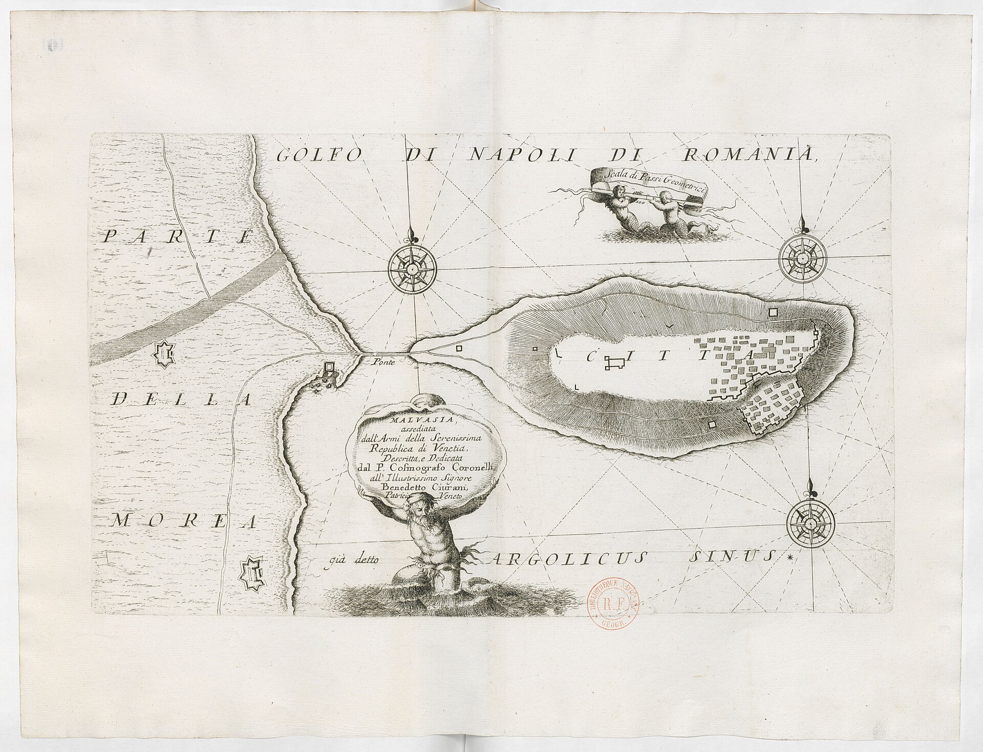
Malvasia assediata (Monemvasia): plan by Vincenzo Coronelli
Plan of Monemvasia island showing enclosing walls and bastions, the bridge (Ponte), harbour and an internal street‑block plan within the citadel.
1689 · Coronelli, Vincenzo Maria (1650-1718). Cartographe · Wikimedia Commons
Public domain (plate dated 1689)
More cities to explore
 GreecePavlopetriExplore it in 1200 BC
 GreeceAthensExplore it in 430 BC · AD 130 · 1835
 GreeceThessalonikiExplore it in 1200 · 1900
 GreeceAtlantisExplore it in 9600 BC
Castles of Europe · Landmarks of Europe · create your own reconstruction.