Historic Cities · Greece
Pavlopetri through the ages
The archaeological site known as Pavlopetri is found in Vatika Bay, off the coast of southern Laconia in Peloponnese, Greece. It is about 5,000 years old, making it the oldest submerged city known in the world. Pavlopetri is unique in having an almost complete town plan, including streets, buildings, and tombs.

Pavlopetri in 1200 BC
The Bronze Age Harbour Town
Pavlopetri in 1200 BC is a working Mycenaean harbour town coming close to its long decline, lying where shallow lagoon and shore meet. Visitors will pass its planned grid of streets and two-storey courtyard houses, see looms and great storage jars, small fishing boats hauled on the strand, and the rock-cut tombs at the town's edge.
The town reads as a low, rectilinear plan set beside a sheltered lagoon: clusters of two-storey courtyard houses arranged on straight streets, yards ringed with large pithoi, and boats drawn up on a shallow sandy strand. Loom weights and pottery fragments punctuate open courtyards. The skyline is horizontal and coastal, the surface pale with sun-bleached clay and stone, and the sea always close enough to shape daily life.
The route: 9 streets, squares and views
Vatika Bay Approach → Harbour Strand → Central Street → Courtyard House Row → Textile Quarter → Pithoi Store → Potters' Street → Rock-cut Tombs → Onou Gnathos Headland
Step inside, 5 interiors
House Court with Loom · Loom Chamber of Weavers · Pithos Storage Chamber · Kiln and Potter's Workroom · Rock-cut Family Chamber
Planned from the Wikipedia record: Pavlopetri.
Its story
The story of Pavlopetri.
Walls Noted in 1904, Mapped in 1968
The submerged walls lying between the islet of Pavlopetri and the Pounta coast of Laconia were first noted in 1904 by the geologist Fokion Negris, who left little record of their extent or their condition. The site was re-discovered in 1967 by Nicholas Flemming and mapped the following year by a team of archaeologists from Cambridge. The name belongs to the islet rather than to the drowned town: Pavlopetri translates literally as Paul's stone, a direct reference to St Paul.
The 1968 team identified fifteen buildings, some with as many as twelve rooms, and two distinct classes of burial: two chamber tombs and close to forty cist graves, a difference the excavators read as a gap in social status. What made the plan worth mapping was its completeness. Because the ground never re-emerged it was neither built over nor turned to agriculture, so streets, buildings and tombs survive in their original layout despite centuries of erosion. It is the oldest submerged city known in the world, and the archaeological site, the islet and the surrounding waters all fall within the Elafonisos Municipality.
Redating the Occupation to the Fourth Millennium BCE
The ruins were first assigned to the Mycenaean period, 1600 to 1100 BCE. Later study pushed the occupation far earlier, and the accounts do not agree on how far: one dating puts settlement back to about 3500 BCE, another to before 2800 BCE at the start of the Bronze Age. Either way the material recovered spans the Final Neolithic and Chalcolithic as well as the Bronze Age, with middle Minoan and transitional pieces among it, and the town is reckoned to be about 5,000 years old.
Loom Weights and Cretan Pithoi
The surveys established what the town did for a living. The quantity of loom weights recovered from the site marked it as the centre of a thriving textile industry. Alongside them came many large pithoi, storage jars from Crete, which point to a major trading port rather than a purely local settlement.
Excavation by the University of Nottingham in the 2011 season reached original deposits carrying evidence that the people of Pavlopetri traded with the Minoans of Crete nearby. Taken with the earlier finds, the evidence is that the town served as a trading hub.
Onou Gnathos and How the Town Went Under
Elafonisos was not an island in antiquity but a peninsula, and Pausanias records its name as Onou Gnathos, donkey's jawbone. Thucydides' History of the Peloponnesian War is likewise read as suggesting that it was joined to the Peloponnese, and incisions cut into the rock on the north side of Elafonisos were used to move goods by cart. While Pavlopetri was inhabited, that connection would have run through the town itself. Rising sea level and earthquakes forcing the ground down have since widened the gap.
In 2010 a team from the Hellenic Centre for Maritime Research used stereo-photogrammetric data from the survey to reconstruct the old shoreline and the ground between Elafonisos and the beaches of Pounta at Vigklafia, in order to work out how and when the site was drowned. Their reconstruction has the town standing two or three metres above the sea when it was built in the fourth millennium BC; by 1200 BC the sea had risen about two metres and left it barely a metre clear, which would explain the complex water system found there. They proposed that three or four earthquakes then lowered it in stages, with tectonic activity between 480 and 650 AD pushing the site down some three metres.
The dating of the drowning is disputed. One account holds that the town was submerged around 1000 BCE by the first of three earthquakes to strike the area; another places the event in 375 AD, in the same earthquake that destroyed Gytheio, with a wide stretch of coastal ground shifting, severing the peninsula that carried Onou Gnathos and leaving Elafonisos an island.
The 2009 Survey: Sonar, Robots and Nine Thousand Square Metres
The fieldwork of 2009 was largely a mapping exercise, and made Pavlopetri the first submerged town digitally surveyed in three dimensions. Sonar techniques developed for military use and for oil prospecting carried much of the work. At least fifteen buildings lie in three to four metres of water, and the 2009 discoveries alone covered 9,000 square metres.
Four further fieldwork sessions were planned from October 2009 as a joint project with the Greek government, aimed at excavation. Working beside the archaeologists from the University of Nottingham was a team from the Australian Centre for Field Robotics, which built several purpose-made robots to survey the site in different ways.
Anchors, Ballast Water and the 2016 Watch Day
The site has been under threat since its rediscovery in 1967. Boats dragging anchors damage the ruins, and small craft passing overhead shift the seabed sediment against them. Large ships in Vatika Bay discharge waste and ballast water, which carries sediment and organisms, some of them invasive, and the chemicals used to clean such ships do further harm. Looting has been a problem, the site having no protection around it, and a nearby power station and the construction of a gas pipeline running from Crete to the Peloponnese add to the pressure.
The research carried out between 2009 and 2013, and the announcement that the site was in danger, drew a campaign in response, seeking to block a port regulation that would allow large ships to anchor in Vatika Bay and to ring the site with a safety net of buoys. Pavlopetri held its first World Monument Watch Day in 2016 and has held one each summer since, and guided underwater tours led by professional archaeologists have run since that year, offered through the Ephorate of Underwater Antiquities and the Greek Ministry of Culture. The town is underwater cultural heritage as defined by the UNESCO Convention on the Protection of the Underwater Cultural Heritage, which protects all traces of human existence underwater a hundred years old or more.
From the archive
Pavlopetri on paper: the place as it was mapped.
A period map that sets the place down, drawn between 1500 and 1850, the ground this page's reconstructions walk. Public domain, with its source named.
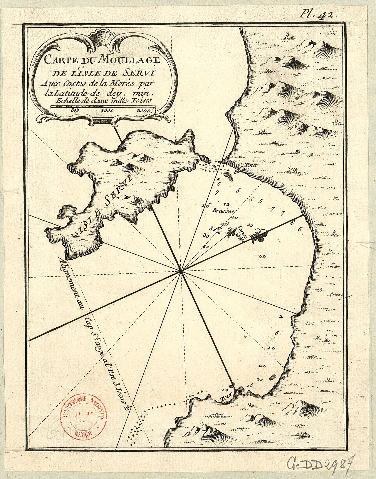
Carte du Mouillage de l'Isle de Servi aux Costes de la Morée, Jacques-Nicolas Bellin
A French naval chart of the anchorage between Elafonisos — the Isle de Servi — and the Laconian shore, with depths sounded in brasses across the strait the drowned town lies under.
1771 · Dépôt des Cartes et Plans de la Marine · Wikimedia Commons
Public domain (chart dated 1771)
More cities to explore
 GreeceMonemvasiaExplore it in 1300
 GreeceAthensExplore it in 430 BC · AD 130 · 1835
 GreeceThessalonikiExplore it in 1200 · 1900
 GreeceAtlantisExplore it in 9600 BC
Castles of Europe · Landmarks of Europe · create your own reconstruction.