Historic Cities · Turkey
Istanbul through the ages
Istanbul is the largest city in Turkey, constituting the country's economic, cultural, and historical center. With a population of over 15 million, it is home to 18% of the population of Turkey. Istanbul is among the largest cities in Europe and in the world by population. It is a city on two continents; about two-thirds of its population live in Europe and the rest in Asia.

Istanbul in AD 550
Justinian's Constantinople
Constantinople under Justinian is the empire's ceremonial heart a generation after Hagia Sophia's dome first astonished the city; the Great Palace, Hippodrome and the colonnaded Mese shape a dense, public centre ringed by mighty land walls. This walk follows the peninsula from the southern approach, through palace forecourts, markets and the racing Hippodrome, and finishes atop the Theodosian ramparts with a view across the Golden Horn.
The skyline is a forest of domes, squat brick-and-ashlar towers, and porphyry columns lifted from Egypt and Greece, punctuated by the new hemispherical dome of Hagia Sophia resting on a ring of light and narrow windows; streets are narrow, paved in worn stone, and shaded by continuous colonnades along the Mese. Marble and gilded stone catch the sun, fishers crowd the quays with gaffed boats, and squat stone lids and low wellheads mark the vast cisterns that lie below almost every block.
The route: 22 streets, squares and views
Sea of Marmara View → Bucoleon Harbour → Great Palace Seawall → Palace of Daphne → Chalke Gate → Augustaion Square → Hagia Sophia Exterior → The Milion → Lower Mese Colonnade → Forum of Constantine → …
Step inside, 13 interiors
Shipwrights' Harbour Shed · Peacock Mosaic Audience Hall · Palace Private Chapel · Bronze Vestibule of Chalke · Augustaion Receiving Hall · Main Nave Under the Dome · Milion Imperial Niche · Covered Mercantile Stoa · Colonnaded Curia of Constantine · Zeuxippus Great Bath Hall · Imperial Loge Above the Arena · Columned Cistern Hall · Golden Gate Ceremonial Hall
Planned from the Wikipedia record: Constantinople.
Istanbul in 1200
Byzantine Constantinople
Constantinople in 1200 stands at the height of its medieval splendour, still ringing with the Komnenian court's wealth and religious prestige even as trading Latins crowd the harbours. This walk moves from the Sea of Marmara across the great domes and colonnades to the Blachernae palaces and the Pantokrator monastery, along the Golden Horn's merchant quays and into the neighbourhoods where Venetian and Genoese ships anchor.
The skyline is a cluster of broad lead-covered domes, squat brick drum-cupolas and the high silhouette of the Theodosian land walls; facades alternate white marble and reddish brick bands, columns reclaimed from Roman temples rise in public squares, and narrow colonnaded streets funnel sunlight and dust. The Golden Horn and inner harbours are crowded with lateen-rigged and galley hulls, timber masts and open warehouses, while palace roofs and church mosaics catch the sun and gleam of gilded interiors.
The route: 22 streets, squares and views
Approach from Sea of Marmara → Pharos Lighthouse Promontory → Neorion Quay → Chalke Gate → Augustaion → Hagia Sophia → Hippodrome → Mese Main Street → Forum of Constantine → Forum Tauri → …
Step inside, 13 interiors
Pharos Chapel of Relics · Neorion Merchant Warehouse · Grand Nave of Hagia Sophia · Imperial Kathisma · Chrysotriklinos Throne Hall · Imperial Audience Hall · Shrine of the Theotokos · Pantokrator Marble Church · Golden Horn Customs Hall · Fondaco of the Venetians · Genoese Merchants' Hall · Great Shipwright Workshop · Columned Cistern Hall
Planned from the Wikipedia record: Constantinople.
Istanbul in 1560
Suleiman's Istanbul
The imperial city stands at the height of Ottoman power under Suleiman: mosques and palaces rise above a dense web of markets, quays and city walls. This walk follows the shoreline, the great processional streets and the crowded bazaars from the Bosphorus and Golden Horn to the new Süleymaniye, showing the public face of the capital in daily use.
In 1560 the peninsula is a compact, layered city of domes, slender minarets and red-tiled houses crowding its seven hills. Stone palaces and mosque complexes sit amid narrow, vaulted bazaars and timber-fronted waterfronts; the shoreline is carved by caiques and laden merchant craft. Roofs glimmer with lead and tile, mosque domes and minarets puncture the skyline, and the city’s streets are a close, sunlit tangle of stalls, arches and workshop doors.
The route: 22 streets, squares and views
Üsküdar Shore View → Üsküdar Quay → Eminönü Quay → Seraglio Point → Bab-ı Hümayun → Topkapı Outer Esplanade → Gülhane Meadow → Ayasofya Exterior → Hippodrome (Atmeydanı) → Divan Yolu → …
Step inside, 14 interiors
Harbour Warehouse Hall · Chamber of Privy Counsel · Imperial Audience Chamber · Vast Imperial Nave · Caravanserai Inner Courtyard · Silk Draper's Showroom · Stone Bedesten Hall · Bookbinders' Workshop · Beyazıt Mosque Prayer Hall · Main Domed Sanctuary · Imaret Kitchen Hall · Early Coffee House · Cannon Foundry Furnace · Stone Tower Chamber
Planned from the Wikipedia record: History of Istanbul.
Istanbul in 1900
Late Ottoman Istanbul
This is Istanbul under Sultan Abdülhamid II at the turn of the century: an imperial capital of minarets, palaces and embassies, strung across the Bosphorus between Stamboul and Pera. The walk follows ferries, the Orient Express at Sirkeci and the crowded Galata Bridge into the Frankish quarters of Pera, past trams, hamals and the stone façades of Dolmabahçe toward the Bosphorus ramparts.
The skyline is a pierced silhouette of imperial mosques, tall minarets and the lower masses of wooden houses and European palaces. Along the Golden Horn and Bosphorus the city alternates stone quays, wooden piers and sailing masts; horse trams and the new electric fittings run beside gas lamps; crowds of porters, sailors, consular flags and café terraces animate steep streets that climb from Galata to Pera and the promontories of Dolmabahçe and Rumeli.
The route: 22 streets, squares and views
Uskudar Shoreline View → Eminönü Ferry Quay → Sirkeci Station Façade → Sirkeci Tram Terminus → Eminönü Quay and Hamals → Galata Bridge Midspan → Yeni Camii Forecourt → Spice Bazaar Approach → Karaköy Waterfront → Galata Tower and Streets → …
Step inside, 15 interiors
Imperial Ferry Waiting Hall · Sirkeci Arrival Hall · Tram Terminus Ticket Hall · Hamals' Weighhouse Lodge · Galata Bridge Fish Café · Yeni Camii Prayer Hall · Spice Bazaar Vaulted Hall · Tünel Lower Station Concourse · Ottoman Bank Grand Hall · Pera Palace Marble Hall · Pera Palace Smoking Room · Asmalı Meyhane Cellar · Dolmabahçe Crystal Staircase · Ortaköy Mosque Chamber · Bebek Yalı Reception Salon
Planned from the Wikipedia record: History of Istanbul.
Its story
The story of Istanbul.
From Megarian Colony to Roman Byzantium, 7th Century BC to AD 200
Digging for the Yenikapı metro station and the Marmaray tunnel turned up, in 2008, the earliest known settlement on the historic peninsula, dating from 6700 BC. A settlement stood near the point of the peninsula in the early 1st millennium BC, linked by modern authors to Lygos, the name Pliny the Elder gives for the site before Byzantium.
The city proper begins with Greek settlers from the Attic town of Megara, who founded Byzantion on the European side of the Bosphorus in the seventh century BC; the accounts differ over the year, 667 BC in one telling and around 657 to 660 BC in others. The colonists built an acropolis beside the Golden Horn, on the site of the earlier Thracian settlements, and it was the strait that made the place: shipping had to pass it. Byzantion was briefly under Persian rule at the turn of the 5th century BC, belonged afterwards to the Athenian League and its successor, won independence in 355 BC and became formally part of the Roman Empire in 73 AD. Backing the usurper Pescennius Niger against Septimius Severus cost it dearly: two years of siege left it devastated by its surrender at the end of 195 AD, and Severus began rebuilding five years later.
New Rome, Capital of the Eastern Empire, 324–565
Constantine the Great became emperor of the whole Roman Empire after defeating Licinius at Chrysopolis on the Bosphorus on 18 September 324, and two months later laid out plans for a new Christian city to replace Byzantium. He called it Nova Roma; almost everyone called it Constantinople. It was proclaimed capital of the Roman Empire on 11 May 330, and on the death of Theodosius I in 395 the empire was divided permanently between his sons, leaving Constantinople the capital of the eastern half.
The city lived off its position at the crossing between Europe and Asia, and off the imperial administration it housed. Nicene Christianity became the official religion of the empire in 381, and the city became the centre of the Greek world and the seat of the Patriarch of Constantinople; Hagia Sophia, built under Justinian I, remained the world's largest cathedral for a thousand years. Under Justinian, who reigned from 527 to 565, the population approached half a million. For most of the Byzantine period this was the largest city in Europe, and the walls and seafront shielded it for centuries against attack from the east.
From the Fourth Crusade to a City of Villages, 1204–1453
Decline set in after the reign of Basil II ended in 1025. In 1204 the Fourth Crusade was diverted from Jerusalem: western armies took Constantinople and stripped it of its treasures, Hagia Sophia was converted to a Catholic church, and Baldwin of Flanders was made Latin Emperor while the crusading princes and the Republic of Venice divided the empire between them. The Byzantines under Michael VIII Palaiologos retook the city in 1261, but its churches, defences and basic services were in disrepair and its population had fallen to about a hundred thousand from half a million in the 8th century.
What followed was not recovery. The city became a scattering of villages inside its walls, Ibn Battuta noted fields sown within them, and by 1453 held less than a tenth of its former population. From the mid-14th century the Ottomans took the smaller towns around it one by one, cutting the supply routes and strangling it slowly.
The Conquest of 1453 and the Forced Repopulation
Mehmed II began the siege on 6 April 1453 with cannon built for the purpose, and entered the city on 29 May; the length of the siege is given as 53 days in one account and 55 in another. In accordance with Islamic law he had offered the emperor Constantine XI three chances to surrender, guaranteeing the residents their riches, beliefs and honour, and been refused. The Theodosian walls were breached in two places, Constantine XI was killed in the fighting, and Mehmed rode to Hagia Sophia and had an imam proclaim the Muslim creed there, converting the cathedral into an imperial mosque because the city had not surrendered peacefully. He ordered three days of plunder.
Most of what remained of the Byzantine population, some 30,000 people, was deported. Repopulating the city then became the sultan's main concern. He issued orders across the empire that Muslims, Christians and Jews should resettle it and that five thousand households be deported there by September, and in 1459 allowed Greeks who had left as slaves or refugees to return. The chronicle of Ashikpashazade records that when an offer of freehold houses and gardens failed to fill the city, "the Sultan commanded that from every land families, rich and poor alike, should be brought in by force". The census of 1477 counted 9,486 households of Muslims, 3,743 of Greeks, 1,647 of Jews and 267 of Christians from the Crimea. The Italians of Galata, who had surrendered before the city fell, kept a measure of self-government and supplied the Ottoman court with interpreters and diplomats for generations, and Mehmed re-established the city as the seat of the Orthodox patriarchate. The Grand Bazaar was built in 1455, Topkapı Palace in 1459 and the Fatih mosque and college in 1463, on the burial ground of the Byzantine emperors.
Capital of the Caliphate, 1517–1908
After the conquest of Egypt in 1517 the Ottoman dynasty claimed the caliphate, and the city remained its seat for four centuries. Under Suleiman the Magnificent, who reigned from 1520 to 1566, the chief architect Mimar Sinan built many of its mosques while ceramics and calligraphy flourished. Its communities lived in self-contained quarters, but plague made no such distinctions, killing rich and poor alike through the 16th century.
The population grew from about 80,000 at Mehmed II's death to some 300,000 by the 18th century and 400,000 in 1800, though a higher count of 570,000 by the end of the 18th century is also given. Rebellion at the start of the 19th century brought Mahmud II to power and led to the Tanzimat reforms; bridges were thrown across the Golden Horn, the city was joined to the European railway network in the 1880s, and a water network, electricity, telephones and trams followed, later than in other European cities. None of it forestalled the decline of the empire.
Genocide, Defeat and Occupation, 1908–1923
The Young Turk Revolution reopened the Ottoman Parliament on 23 July 1908 after thirty years, Abdul Hamid II was deposed in 1909, and the Balkan wars were followed by the coup of 1913 that brought the regime of the Three Pashas. The empire entered the First World War on the side of the Central Powers. The deportation of Armenian intellectuals from the city on 24 April 1915 was among the events that marked the start of the Armenian genocide. Between 1914 and 1927 the city's Christian population fell from 450,000 to 240,000 as a result of Ottoman and Turkish policies of Turkification and ethnic cleansing. An Allied operation to capture the city failed when the Ottoman army repulsed the British and ANZAC landing force in the Gallipoli campaign.
The Armistice of Mudros was signed on 30 October 1918 and a French brigade entered the city on 12 November, followed the next day by British, Italian, Greek and French troops. The Allies dissolved the Ottoman Parliament on 11 April 1920, and many of its members joined the national movement whose Grand National Assembly was established at Ankara that month; the Istanbul government's signature on the Treaty of Sèvres that August was rejected there. The Assembly abolished the sultanate on 1 November 1922 and the last sultan, Mehmed VI, left aboard a British warship on 17 November. The Treaty of Lausanne was signed on 24 July 1923; the last Allied forces left on 4 October and Turkish troops entered the city two days later.
Losing the Capital: Wealth Tax, Pogrom and Sprawl, 1923–2023
The Republic was declared on 29 October 1923 with Ankara as its capital, and the city that had been the capital of four empires was overlooked in favour of the new capital, and its population fell from an estimated 1,125,000 in 1914 to about 500,000 in 1924. The name Constantinople, in use for sixteen centuries, was officially replaced by İstanbul under the Postal Services Law of 28 March 1930. From 1936 large-scale planning under Henri Prost and his successors cut new squares, boulevards and avenues through the city, often demolishing historic buildings.
The wealth tax of 1942 was levied at much higher rates on non-Muslims and forced the transfer or liquidation of many businesses owned by religious minorities. During the Istanbul pogrom of September 1955 Greek businesses were destroyed and Greeks were killed, wounded and sexually assaulted; Jews, Armenians and Georgians were also targeted, and most of the remaining Greeks left. Further mass expulsions followed in 1964–65, when Greek citizens who had been exempted from the population exchange under the Treaty of Lausanne were ordered out of the country, spouses holding Turkish citizenship included, after Turkey and Greece came close to war over Cyprus. The city's Greek population fell from 110,000 in 1919 to 2,500 by the end of the 20th century. The Theological School of Halki closed in 1971 rather than accept attachment to Istanbul University under a law nationalising private higher education, and minority emigration to Europe and North America continued through the political turmoil of 1960 to 1980.
From the 1970s the population climbed steeply as people came from Anatolia to work in the new factories on the outskirts; housing demand swallowed outlying villages and forests, and the Bosphorus Bridge, opened in 1973, drew still more migration. In March 1995 twenty-three people were killed and hundreds injured in the Gazi Massacre, which began with an armed attack on coffee shops in the neighbourhood in which an Alevi religious leader was killed and continued when police fired on the protests that followed. Taksim Square was the centre of the Gezi Park protests in 2013 over press freedom, assembly and the government's encroachment on secularism, and soldiers taking part in the attempted coup of July 2016 surrendered on the Bosphorus Bridge. Bomb attacks killed ten German tourists at Sultanahmet in January 2016, thirty-eight outside the Beşiktaş stadium that December, thirty-nine at a nightclub on 1 January 2017 and six on İstiklal Avenue in November 2022.
Istanbul is the largest city in Turkey and home to 18% of its people, with a population of over 15 million, about two-thirds of them on the European side of the Bosphorus. Its Kurdish population, estimated at between two and four million, is the largest minority among Turkish citizens in the city, and as of August 2023 it held more than 530,000 refugees of the Syrian civil war, the highest number of any Turkish city.
From the archive
Istanbul on paper: the old town as it was mapped.
A period plan or bird's-eye view of the old town, drawn between 1500 and 1850, the streets this page's reconstructions walk. Public domain, with its source named.
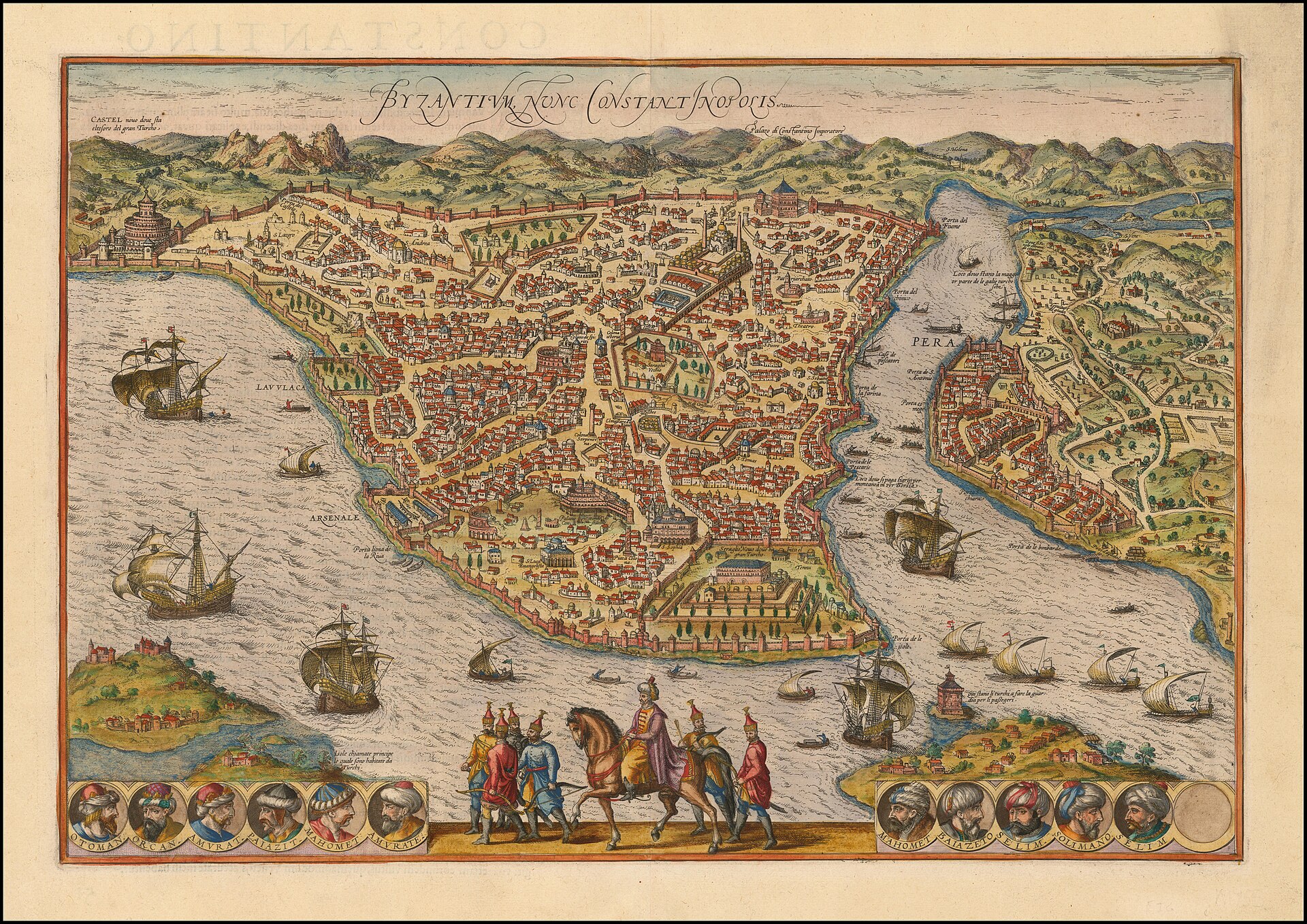
Bird's-eye view of Byzantium, nunc Constantinopolis, from Braun & Hogenberg's Civitates Orbis Terrarum
Shows the walled old town with Hagia Sophia and Topkapı Palace, sea walls and gates, the Golden Horn and Galata (Pera) across the water with ships in the Bosphorus.
1572 · Georg Braun / Frans Hogenberg · Wikimedia Commons
Public domain (plate dated 1572)
Ships tied to Istanbul
- Emden: Lay at Istanbul during the funeral of Ataturk in October 1938
- Greek cruiser Georgios Averof: Raised the Greek flag before Hagia Sophia when the Allied fleet reached Constantinople
- SMS Goeben: Fled to Constantinople in 1914; later carried Ataturk's remains from Istanbul
More cities to explore
 NetherlandsUtrechtExplore it in 1400 · 1700
 EnglandLondonExplore it in AD 200 · 1390 · 1600 · 1885
 FranceParisExplore it in 1250 · 1670 · 1789 · 1889
 GermanyBerlinExplore it in 1750 · 1871 · 1928
Castles of Europe · Landmarks of Europe · create your own reconstruction.