Historic Cities · Luxembourg
Luxembourg City through the ages
Luxembourg, also known as Luxembourg City, is the capital city of Luxembourg and the country's most populous commune. Standing at the confluence of the Alzette and Pétrusse rivers in southern Luxembourg, the city lies in the center of Western Europe, situated 213 km (132 mi) by road from Brussels and 209 km (130 mi) from Cologne.

Luxembourg City in 1860
Gibraltar of the North
Luxembourg in 1860 is the fortress at its final strength: triple rings of bastions, rock-cut casemates and glacis dominate the town and its deep river gorges, garrisoned chiefly by Prussian troops. This walk follows the approach from the plain into the gates, threads the upper town and the Corniche above the Grund, and climbs to the Kirchberg heights to show military works, workshops and the new railway viaduct.
The skyline is a serrated line of ramparts, hornworks and angled bastions set above steep, green river gorges; the limestone cliff faces are pierced by dark casemate mouths. Slate roofs, narrow streets and clustered church spires rise within the fortifications while sentries and Prussian colours punctuate esplanades. Smoke from tanners and bakeries drifts from the Alzette valley, and an iron-arched railway viaduct now spans the Pétrusse, bold against the ramparts.
The route: 16 streets, squares and views
Road from Arlon → Porte de Trèves → Boulevard Royal → Grand Ducal Palace → Place d'Armes → Notre-Dame Cathedral → Marché aux Poissons → Bock Promontory → Bock Casemate Mouths → The Corniche → …
Step inside, 9 interiors
Trier Gate Guardroom · Garrison Canteen and Mess · Bandstand Pavilion Interior · Cathedral Nave and Choir · Powder Magazine Vault · Rock-cut Casemate Gallery · Tanner's Beam-and-Tub Workshop · Viaduct Signal Cabin · Tower Sentry Room
Planned from the Wikipedia record: Fortress of Luxembourg.
Its story
The story of Luxembourg City.
Siegfried Trades for Lucilinburhuc, 963
A fortified tower may have guarded the meeting of two Roman roads on the ground the city now occupies, though the historian Jemp Kunnert holds that no structure is believed to have stood at that crossing. The earliest known settlements inside the modern city boundaries were made by Frankish colonisers in the Alzette valley, around what are now Dommeldange, Pfaffenthal and the Grund. As of 926, seventy-three people were living in the valley between Dommeldange and Clausen.
In 963 Siegfried I of the Ardennes, a close relative of King Louis II of France and of Emperor Otto the Great, acquired the castellum Lucilinburhuc, "small castle", by an exchange treaty with the abbey of Saint Maximin in Trier. That structure, built around the ninth or early tenth century, stood on what is now the Fish Market, and served as an outpost to the fortified castle Siegfried then began on the Bock rock, which kept the name Lucilinburhuc and is first mentioned in the same treaty. In 987 Archbishop Egbert of Trier consecrated five altars in the Church of the Redemption, today St Michael's Church; the Fish Market grew at the road junction beside it, and the city grew around the market.
Ermesinde's Charter and the Walls of 1340
The first fortifications went up as early as the tenth century, and the site's geography kept it militarily significant for the rest of its history. Countess Ermesinde granted the city its charter in 1244, by which time Luxembourg had spread westward around the new St Nicholas Church, today the Cathedral of Notre Dame, behind new walls enclosing five hectares. In about 1340, under John the Blind, a further ring of fortifications was built. It stood for more than five centuries, until 1867.
Burgundian, Spanish and Austrian Hands, 1443–1740s
In 1443 the Burgundians under Philip the Good took Luxembourg, and the city passed into the Burgundian and then the Spanish and Austrian empires. Under those Habsburg administrations the castle was repeatedly strengthened, so that by the sixteenth century Luxembourg was one of the strongest fortifications in Europe. It changed hands repeatedly all the same: the Burgundians, the Spanish, the French, the Spanish again, the Austrians, the French again and the Prussians each conquered it in turn.
On 11 June 1554, during a storm, lightning struck the Franciscan convent church on the site of the present Place Guillaume II, whose attic was in use as a gunpowder magazine. The explosion threw burning pieces of the church roof across a wide radius and set fire to the mostly thatched or shingled roofs around it. Much of the Ville Haute was destroyed, with an unknown number of casualties. The Dutch military engineer Sebastiaan van Noyen drew up a reconstruction plan, but most of it went unimplemented, disregarded by townspeople rebuilding their own houses; his proposed central square, the forum novum, was realised only in 1671 as the Place d'Armes.
The casemates belong to the following century. Spain began the tunnels in 1644 and drove 23 kilometres of them; they were enlarged under French rule by Marshal Vauban, and augmented again under Austrian rule in the 1730s and 1740s.
The Gibraltar of the North, 1792–1815
During the French Revolutionary Wars the city was occupied by France twice: briefly in 1792–93, and again after a seven-month siege. It held out long enough that the French politician and military engineer Lazare Carnot called Luxembourg "the best fortress in the world, except Gibraltar", which gave the city its nickname, the Gibraltar of the North. The Austrian garrison surrendered nonetheless, and Luxembourg was annexed by the French Republic as part of the département of Forêts, with the city as its préfecture.
The Treaty of Paris of 1815, ending the Napoleonic Wars, placed Luxembourg City under Prussian military control within the German Confederation, while sovereignty passed to the House of Orange-Nassau in personal union with the United Kingdom of the Netherlands.
Dismantling the Fortress, 1867–1890
After the Luxembourg Crisis, the Treaty of London of 1867 required the fortifications to be pulled down and the Prussian garrison withdrawn. The city then covered 127 hectares and the defensive works around it 177 hectares, ringed by a building-restriction perimeter of nearly a kilometre that the Austrians had imposed in 1749 for security reasons and that had made further growth impossible. Demolition took sixteen years, cost 1.5 million gold francs, and destroyed over 24 kilometres of underground defences and four hectares of casemates, batteries and barracks. On the cleared ground the French landscape architect Édouard André laid out, between 1871 and 1878, the roughly nineteen-hectare municipal park that still bears his name.
When Grand Duke William III died in 1890 without a male heir, the Grand Duchy passed out of Dutch hands to an independent line under Grand Duke Adolphe. Luxembourg, independent in theory only until then, became a fully independent country, and its capital recovered some of the standing it had lost in 1867.
Occupied Twice, 1914–1945
Despite the country's efforts to stay neutral, Germany occupied Luxembourg on 2 August 1914. On 30 August Helmuth von Moltke moved his headquarters to Luxembourg City to be nearer his armies in France, in expectation of a swift victory; the victory never came, and the city housed the German high command for another four years. As the occupation ended, communists declared a socialist republic in the city on 9 November 1918. It lasted a few hours. In 1920 and 1921 the communes of Eich, Hamm, Hollerich and Rollingergrund were merged into the city, taking it from 3.55 to 51.52 square kilometres and making it the largest commune in the country, a position it held until 1978.
Germany occupied Luxembourg again in 1940. The Nazi authorities would not allow Luxembourgers self-government and gradually absorbed the country into the Third Reich by attaching it administratively to a neighbouring German province. The capital's streets were all given new German names, announced on 4 October 1940: the Avenue de la Liberté, a major road leading to the railway station, became Adolf-Hitlerstraße. On 26 March 1943 the occupiers enlarged the city by taking in Strassen, Walferdange and part of Hesperange. Luxembourg City was liberated on 10 September 1944 and the pre-occupation boundaries were restored; the German V-3 cannon shelled the city at long range through December 1944 and January 1945. The Luxembourg American Cemetery and Memorial at Hamm, inside the city limits, holds 5,076 American war dead, among them General George S. Patton, with a memorial to a further 371 whose remains were never recovered or identified.
Seat of European Institutions, 1952 Onwards
Luxembourg abandoned neutrality after the war and became a founding member of several intergovernmental and supranational bodies. In 1952 the city became the headquarters of the High Authority of the European Coal and Steel Community. The High Authority was merged with the other European commissions in 1967, and although the city was no longer the seat of the ECSC it hosted part-sessions of the European Parliament until 1981. It remains the seat of the Parliament's secretariat, the Court of Justice of the European Union, the European Court of Auditors and the European Investment Bank, with several European Commission departments and, for three months of the year, meetings of the Council of the European Union. Most of these sit in the Kirchberg quarter.
The old quarters and fortifications are inscribed on the UNESCO World Heritage List, the listed area lying mainly in the Ville Haute. The city had 137,696 inhabitants as of 31 December 2025, drawn from 160 nationalities; foreign residents make up 69.5 per cent of them, the highest proportion of any commune in the country. Trams ran through the city between 1875 and 1964 and returned in December 2017, the first new line completed in March 2025 between the airport and the Stade de Luxembourg; public transport across the country, rail, bus and tram alike, has been free since 29 February 2020.
From the archive
Luxembourg City on paper: the old town as it was mapped.
A period plan or bird's-eye view of the old town, drawn between 1500 and 1850, the streets this page's reconstructions walk. Public domain, with its source named.
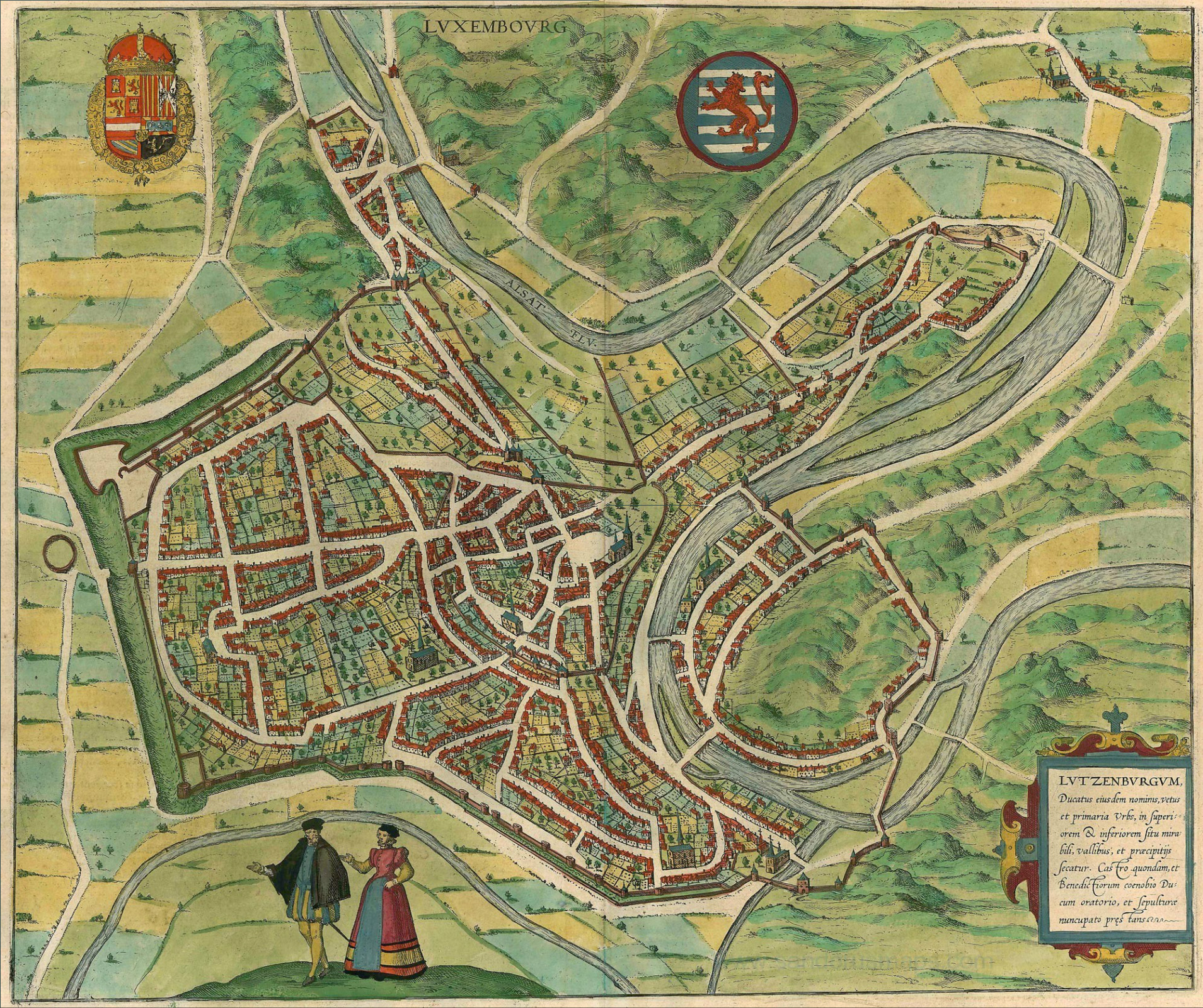
Bird's-eye view of Luxembourg, from Braun & Hogenberg's Civitates Orbis Terrarum
Depicts the walled old town with bastioned fortifications, gates, winding streets, river loops and prominent church spires.
1581 · Braun & Hogenberg · Wikimedia Commons
Public domain (plate dated 1581)
Castles of Luxembourg City


More cities to explore
 GermanyTrierExplore it in AD 310 · 1150 · 1810
 GermanyAachenExplore it in AD 800 · 1500
 NetherlandsUtrechtExplore it in 1400 · 1700
 EnglandLondonExplore it in AD 200 · 1390 · 1600 · 1885
Castles of Europe · Landmarks of Europe · create your own reconstruction.