Historic Cities · France
Reims through the ages
Reims is the most populous city in the French department of Marne, and the 12th most populous city in France. The city lies 129 km (80 mi) northeast of Paris on the Vesle river, a tributary of the Aisne.

Reims in 1429
City of Coronations
This is Reims at the climax of a long royal ritual life: a midsummer city emptied and thronged at once for the Sacre of Charles VII, the Holy Ampulla brought from Saint-Remi, and the Maid's banner on the parvis. The walk shows the cathedral's west front and parvis, the Palace of Tau and Abbey of Saint-Remi, and the cloth halls, quays and timbered lanes where the town's wool and dyeing trades gather.
Dominated by the soaring stone towers and sculptured west front of Notre‑Dame de Reims, the city is a compact knot of steep, timber‑framed houses, tiled roofs and narrow streets folded toward the river Vesle. Pale weathered limestone, dark oak timbers and reddened clay tiles catch strong summer light; smoke and the odour of dyers rise from the quays. Bells and pennons animate the skyline while market stalls and cloth‑stretched yards give the lower town a busy, horizontal texture.
The route: 16 streets, squares and views
Road from Épernay → Porte de Mars → Pont over the Vesle → Quai de la Vesle → Halles aux Draps → Rue des Teinturiers → Grande Rue → Place du Marché → Timbered Market Lanes → Rue du Cloître → …
Step inside, 7 interiors
Drapers' Guild Hall · Timbered Quarter Tavern · High Nave of Notre‑Dame · Banqueting Hall of the Tau · Palace Newel Stair · Long Romanesque Nave · Dyers' Workshop
Planned from the Wikipedia record: Coronation of the French monarch.
Reims in 1900
Champagne Capital
Reims in 1900 is the wine city's high Belle Époque: the soot-dark Gothic cathedral presides over tram wires and elegant arcades while millions of bottles rest in chalk caverns beneath the streets. The walk passes cathedral forecourts and the great champagne houses, busy shopping streets and riverside quays, then out to the vineyards climbing the Montagne de Reims beyond the boulevards.
A dense low skyline of stone and slate is pierced by the soaring Gothic cathedral, its west front darkened by urban soot and crowned with carved angels. Broad boulevards and arcaded squares open between rows of five- and six-storey stone façades, while horse-drawn carts and electric tramcars thread narrow commercial streets. Cream-coloured bakeries and the crenellated façades of champagne firms sit above entrances into the white chalk crayères that honeycomb the ground beneath the city.
The route: 16 streets, squares and views
Montagne de Reims Vineyards → Gare de Reims → Place Drouet-d'Erlon → Rue de Vesle → Place Royale → Porte de Mars → Place de la République → Pommery Works → Place du Cardinal-Luçon → Cathedral West Front → …
Step inside, 8 interiors
Grand Arrival Hall · Champagne Tasting Salon · Biscuits Roses Oven Room · Chalk Crayère Stair · Riddling Cellar · Cathedral Nave · Salle du Tau · Basilica Nave
Planned from the Wikipedia record: Reims.
Its story
The story of Reims.
Durocortorum and the Loyalty of the Remi
Reims began as the capital of the Remi, a Gaulish tribe, founded around 80 BC on the Vesle, a tributary of the Aisne, north-east of Paris. During Julius Caesar's conquest of Gaul between 58 and 51 BC the Remi allied themselves with Rome, and their fidelity through the successive Gallic insurrections secured them the special favour of the imperial power. The Latin name Durocortorum is hypothesised to derive from a Gaulish form meaning 'Door of Cortoro-'; the city later took the name of the tribe itself, and the modern French Reims descends from the accusative of that name. Estimates of the Roman city's population at its height range from 30,000 to 50,000, or perhaps as high as 100,000.
Christianity had become established by 260, when Sixtus of Reims founded the diocese; it was raised to an archdiocese around 750. The consul Jovinus, an influential supporter of the new faith, repelled the Alamanni when they invaded Champagne in 336. The Vandals took the city in 406 and killed its bishop, Nicasius, and in 451 Attila the Hun put Reims to fire and sword.
The Baptism of Clovis and the Right to Crown Kings
In 496, ten years after Clovis, king of the Salian Franks, won his victory at Soissons, the bishop Remigius baptised him using oil from a sacred phial purportedly brought from heaven by a dove and afterwards preserved at the Abbey of Saint-Remi. Over the following centuries the events at that crowning became a symbol used by the monarchy to claim the divine right to rule, and the reason the city is called in French la cité des sacres, the coronation city.
The city's standing with the Frankish and then the French crown followed from it. Pope Stephen II met Pepin the Short at Reims, Pope Leo III met Charlemagne there, and in 816 Pope Stephen IV crowned Louis the Debonnaire in the city. Louis IV gave Reims and its countship to Archbishop Artaldus in 940. Under Archbishop Adalberon, in office from 969 to 988, it became a centre of intellectual culture: Adalberon and the monk Gerbert, later Pope Silvester II, founded schools teaching the classical liberal arts, and Adalberon took a leading part in the dynastic revolution that put the Capetians in place of the Carolingians. Louis VII made Archbishop William of Champagne a duke and peer, and the archbishops of Reims took precedence over the realm's other ecclesiastical peers.
They held the important prerogative of consecrating the kings of France, which they exercised, with a few exceptions, from Philippe II Augustus, anointed in 1179, to Charles X, anointed in 1825. The Palace of Tau, built between 1498 and 1509 and partly rebuilt in 1675, served as the archbishop's palace and as the king's residence at his coronation, with the royal banquet held in its Salle du Tau.
Charter, English Occupation and the Salt-Tax Revolt, 1139–1590
Louis VII granted the city a communal charter in 1139. The English made a futile attempt to take Reims by siege in 1360, and the Treaty of Troyes ceded it to them in 1420; French patriots expelled them on the approach of Joan of Arc, who in 1429 had Charles VII consecrated in the cathedral. Her entry is still commemorated each June at the Fêtes Johanniques. In 1461 a revolt caused by the salt tax was cruelly suppressed by Louis XI.
During the French Wars of Religion the city sided with the Catholic League in 1585 and submitted to Henri IV only after his victory at Ivry in 1590. The English College spent some years at Reims in about the same period.
Plague, the Lost Chef-Lieu and the Allied Armies, 1635–1814
Plague struck in 1635 and again in 1668, followed by an epidemic of typhus in 1693–1694. The Hôtel de Ville was erected in the same century and enlarged in the nineteenth, its pediment carrying an equestrian statue of Louis XIII; the Place Royale, with Jean-Baptiste Pigalle's statue of Louis XV, was laid out in the eighteenth. Some of the September Massacres of 1792 took place in Reims.
The Revolution also cost the city its administrative rank. It is often argued that Châlons-en-Champagne took the department's chef-lieu under the Revolution because the revolutionary legislators wished to efface the historical importance of the coronation city, Châlons having been the seat of the intendants of Champagne under the Ancien Régime and lying centrally in the new department. Reims is by far the most populous commune of the Marne without being its prefecture. In the invasions of the War of the Sixth Coalition in 1814, the anti-Napoleonic allied armies captured and recaptured the city.
Wool, Rail and the 1909 Aviation Meet
The Eastern Railways completed the Paris-Strasbourg main line in 1852, with branch lines to Reims and Metz. The British inventor and manufacturer Isaac Holden had opened plants at Reims and at Croix; by the 1870s they were producing almost 12 million kilograms of combed wool a year and accounted for 27 per cent of all the wool consumed by French industry.
The Franco-Prussian War broke that run. In 1870–1871 the victorious Germans made Reims the seat of a governor-general and impoverished it with heavy requisitions. From 1874 a chain of detached forts was built in the vicinity, the French Army having selected the city as one of the chief defences of the northern approaches to Paris.
On 30 October 1908 Henri Farman made the first cross-country flight, from Châlons to Reims, and in August 1909 the city hosted the first international aviation meet, the Grande Semaine d'Aviation de la Champagne, with Glenn Curtiss, Louis Blériot and Louis Paulhan among those taking part.
The Cathedral in 1914 and the Surrender in 1945
Hostilities in the First World War greatly damaged Reims. German bombardment and the fire that followed in 1914 did severe damage to the cathedral, and the ruined building became one of the central images of the anti-German propaganda produced in France during the war, presented alongside the ruins of the Ypres Cloth Hall and the university library at Louvain as evidence that German aggression targeted the cultural landmarks of European civilisation. An international effort to restore the cathedral from the ruins has continued since the war ended, and the city centre was largely rebuilt afterwards.
The Second World War damaged the city further. The bronze Génie on the Subé fountain in the Place Drouet-d'Erlon was removed by the Germans, and was not replaced, by a gilded winged Victory, until 1983. At 02:41 on the morning of 7 May 1945, at the Supreme Headquarters Allied Expeditionary Force in Reims, General Eisenhower and the Allies received the unconditional surrender of the German Wehrmacht; General Alfred Jodl, the German chief of staff, signed it as the representative of the German president, Karl Dönitz. The building is now the Museum of the Surrender.
Champagne, Chalk and the Modern City
Reims lies on the northern edge of the Champagne wine region and, with Épernay and Ay, is one of the centres of champagne production. Many of the largest houses, the grandes marques, have their headquarters in the city, and the wine ages in a maze of cellars and tunnels cut into the chalk beneath it, some of the passages dating back to Roman times. The origin of champagne is usually placed in the seventeenth century, with the method of securing the sparkle attributed to Dom Pérignon, and the trade has been one of the historic supports of the city's economy.
The Université de Reims Champagne-Ardenne was founded in 1548 and teaches more than 18,000 students in the city; Sciences Po opened a campus in the former Jesuit College in 2010, and the business school created in 1928 became Reims Management School in 2000 and then NEOMA. Motor racing and football gave the city a further reputation: the Grand Prix de la Marne was run at the Reims-Gueux circuit between 1925 and 1969, the French Grand Prix took place there fourteen times between 1938 and 1966, and Stade Reims became the outstanding team in France in the 1950s and early 1960s, twice reaching the final of the European Cup of Champions.
Reims functions as a subprefecture of the Marne within the region of Grand Est, and co-operates with 142 other communes in the Communauté urbaine du Grand Reims; its population was 177,674 in 2023. A tramway opened in 2011. The cathedral, the adjacent Palace of Tau and the Abbey of Saint-Remi were listed together as a UNESCO World Heritage Site in 1991, for their Romanesque and Gothic architecture and their historical importance to the French monarchy.
From the archive
Reims on paper: the old town as it was mapped.
A period plan or bird's-eye view of the old town, drawn between 1500 and 1850, the streets this page's reconstructions walk. Public domain, with its source named.
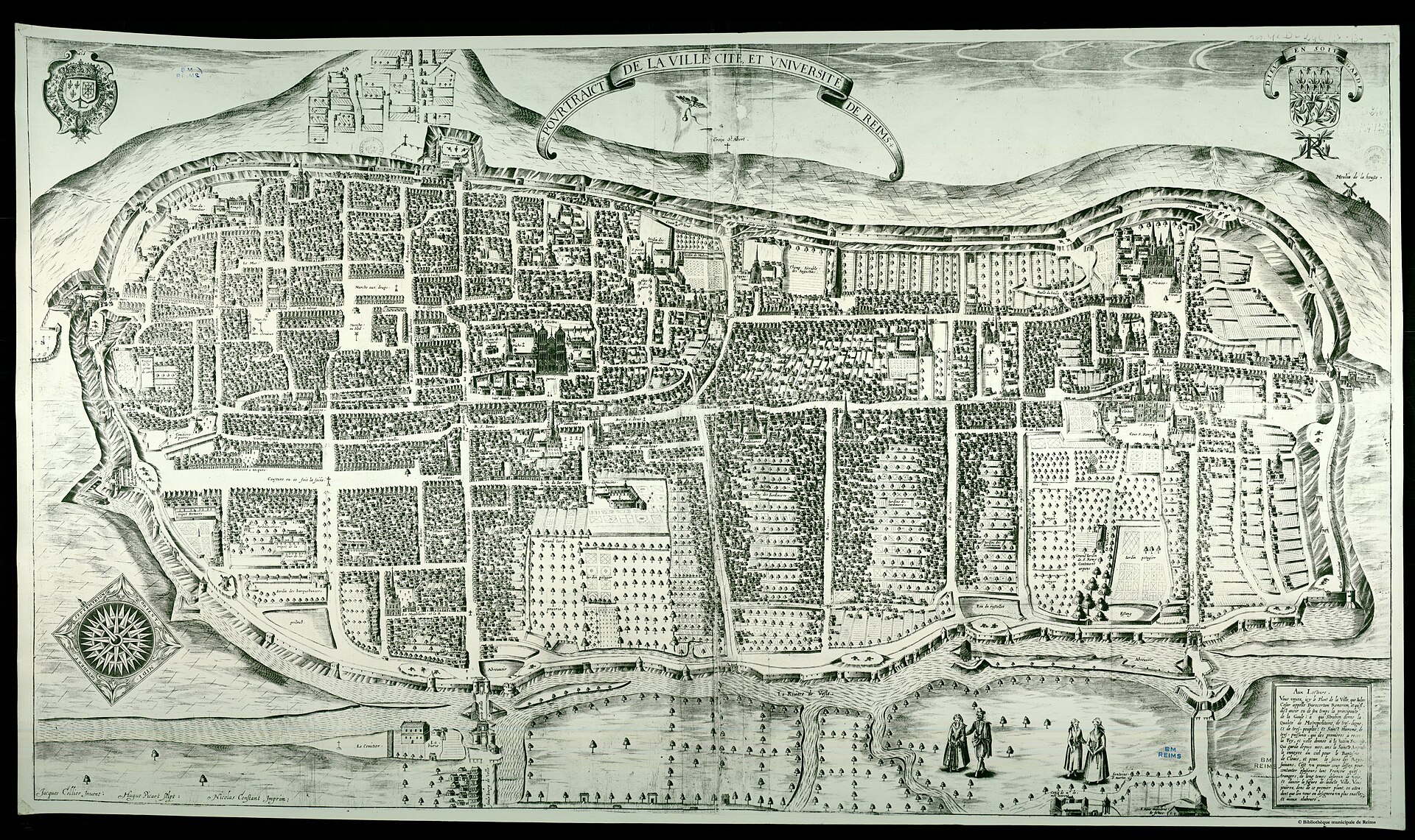
Pourtraict de la ville, cité et université de Reims (bird's-eye view) engraved by Hugues Picart after Jacques Cellier
Walled bird's-eye plan showing curtain walls and bastions, principal gates, the cathedral, city street grid and the river with bridges.
1618 · inconnu. Versement et modifications ː G.Garitan · Wikimedia Commons
Public domain (plate dated 1618)

More cities to explore
 FranceParisExplore it in 1250 · 1670 · 1789 · 1889
 LuxembourgLuxembourg CityExplore it in 1860
 FranceRouenExplore it in 1431 · 1540 · 1876
 FranceLyonExplore it in AD 100 · 1500 · 1835
Castles of Europe · Landmarks of Europe · create your own reconstruction.