Historic Cities · Iceland
Reykjavík through the ages
Reykjavík is the capital and largest city of Iceland. It is located on the southern shore of the Faxaflói bay in southwest Iceland and has a latitude of 64°08′ N, making it the world's northernmost capital of a sovereign state.

Reykjavík in 1900
Timber-town Reykjavík
Reykjavík in 1900 is a compact timber-and-turf capital of roughly six thousand people, a coastal town gathered at the edge of Faxaflói bay. The walk traces the town from the fishing beach and drying racks to Laugavegur's wooden shops, through turf lanes and Austurvöllur with the Alþingi and cathedral, ending at a high view toward Viðey and the blue bulk of Esja.
The skyline is low and domestic: one- and two-storey timber houses with painted weatherboards, interspersed with older turf-roofed cottages and sod walls. Narrow muddy streets and short wooden bridges follow a small brook; chimneys send thin columns of smoke into grey northern light. The stone Alþingishúsið and the white cathedral mark Austurvöllur, while the shore offers boats hauled up on sand, long wooden drying-racks, and the distant islands of Viðey and the dark mass of Esja.
The route: 22 streets, squares and views
Approach from Viðey → Grófin fishing beach → Hafnarstræti → Vesturgata → Lækjargata → Bridge over the Lækur → Bankastræti → Laugavegur shops → Aðalstræti → Grjótaþorp lanes → …
Step inside, 13 interiors
Viðey Farmhouse Parlor · Fish Curing Shed · Harbour Warehouse Loft · Baker's Oven Room · Counting-House · Merchant's Barrel Shop · Turf-Walled Farm Kitchen · Latin School Classroom · Alþingi Chamber · Cathedral Box Pews · Minister's Parlour · Pond Boathouse · Farm Longroom
Planned from the Wikipedia record: Reykjavík.
Reykjavík in 1930
Reykjavík of the Millennium
Reykjavík in 1930 is a small but energetic capital at the moment of Iceland’s thousand‑year Alþingi millennium, when the city fills with visitors, flags and civic ceremony. The walk crosses the new stone harbour and trawler quays, the market streets and saltfish yards, the parliament lawns and the Tjörnin pond, and finishes on a high point that looks across Faxaflói to Esja and Viðey.
Low rows of timber houses and corrugated iron warehouses cluster around a new stone harbour; short stone and concrete public buildings punctuate a largely wooden town. The new trawler quays are lined with dark hulls, drying racks and saltfish sheds, while Laugavegur and Bankastræti offer painted shopfronts and awnings. Skólavörðuholt rises behind the town, Fríkirkjan’s wooden spire and Landakot’s concrete church stand out, and the bay’s wide sweep opens to Viðey and the blue bulk of Esja.
The route: 22 streets, squares and views
Approach from Faxaflói → Viðey Ferry Landing → Grandagarður Stone Harbour → Trawler Quays → Grandi Drying Yards → Tryggvagata Warehouse Row → Lækjargata by the Stream → Posthusstræti & Hotel Borg → Austurvöllur Park → Alþingishúsið Exterior → …
Step inside, 14 interiors
Viðey Manor Drawing Room · Harbourmaster's Office · Trawler Galley Below Deck · Saltfish Curing Shed · Warehouse Counting Office · Hotel Borg Dining Room · Alþingi Assembly Chamber · Publisher's Back Room · Skólavörðuholt Schoolroom · Fríkirkjan Nave · Landakot Basilica Nave · Municipal Records Office · Sportsmen's Changing Room · Communal Washhouse Pool Room
Planned from the Wikipedia record: Reykjavík.
Its story
The story of Reykjavík.
Ingólfur's Farm and the King's Estate, 874–1703
Landnámabók places the settlement of Iceland at Reykjavík, with Ingólfur Arnarson arriving from Norway in 874; the same account is elsewhere dated to around 870. Ingólfur is said to have chosen the spot by a traditional Norse method (casting his high-seat pillars overboard within sight of land and promising to settle wherever the gods brought them ashore), after which two of his slaves searched the coasts for three years before finding the pillars in the bay that became Reykjavík. Excavations in the modern centre, in Aðalstræti, Suðurgata and Kirkjustræti, have turned up traces of habitation from about 870. The name comes from the Old Norse reykr, smoke, and vík, bay, and is said to have been prompted by steam rising from hot springs nearby; it originally covered both the bay and Ingólfur's farm, fell out of use shortly after settlement in favour of Vík á Seltjarnarnesi, and was revived only when a town began to grow centuries later.
A church stood beside the farm from at least 1200, and Augustinian monks founded a monastery on the island of Viðey in 1226. The Danish king bought the Reykjavík estate from the widow of the sheriff Narfi Ormsson on 17 July 1613, making it a royal property. The land register of 1703 lists eight tenant holdings attached to it: Landakot, Götuhús, Grjóti, Melshús, Hólakot, Skálholtskot, Stöðlakot and Suðurbær. The site of the modern city centre was farmland until the 18th century.
The Innréttingar Wool Works, 1752
In 1752 King Frederik V of Denmark donated the estate of Reykjavík to the Innréttingar corporation, whose leading figure was Skúli Magnússon; the Crown also gave over land it held at Örfirisey. Several houses were built in the 1750s to house the wool industry, which was the town's most important employer for a few decades and the original reason for its existence. The corporation also took up fisheries, sulphur mining, agriculture and shipbuilding. Sixteen houses were put up for the Innréttingar, a considerable increase for the time, and traces of two of them survive. The country's first prison was built between 1761 and 1771, a substantial stone house on Lækjargata that today holds the Government Offices of Iceland.
The Trading Charter of 1786
A royal commission recommended in 1774 that Reykjavík be made the country's chief town, and proposed renaming it Kristjánsvík in honour of Christian VII. On the recommendation of a second commission, the bishop's see was moved from Skálholt to Reykjavík and a new cathedral built there. In 1786 the Danish Crown abolished monopoly trading and granted exclusive trading charters to six communities around the country; Reykjavík was one of them and the only one to keep its charter permanently, which is why 1786 is regarded as the date of the town's founding. A school, Hólavallaskóli, was founded there the same year.
Trading rights were limited to subjects of the Danish Crown, and Danish merchants went on dominating Icelandic trade, expanding their business over the following decades. Only after 1880, when free trade was opened to all nationalities, did the influence of Icelandic merchants begin to grow. Through the nineteenth century the town filled with dense clusters of small fishermen's houses.
The Alþingi Returns, 1845
Icelandic nationalist sentiment gained ground in the nineteenth century, and independence advocates recognised that a strong Reykjavík, the country's only town, was fundamental to the aim. In 1845 the Alþingi, the general assembly formed in 930 and suspended some decades earlier at its old seat of Þingvellir, was re-established in Reykjavík. It functioned at first only as an advisory body to the king on Icelandic affairs, but its presence effectively made the town the capital. The grammar school was moved in from Bessastaðir the following year, and the parliament house was completed in 1881.
A constitution in 1874 gave the Alþingi limited legislative powers and made it substantially the institution it is today. Executive power followed: Home Rule was granted in 1904 with the creation of the office of Minister for Iceland in Reykjavík, and on 1 December 1918 Iceland became a sovereign state, the Kingdom of Iceland, in personal union with the Danish Crown.
Trawlers, the Harbour and the Frost Winter, 1891–1932
A navigation school opened in 1891, once decked ships had reached the country. Páll Einarsson took office as the town's first mayor in 1908, the year that women elected from women's lists in the Reykjavík town council elections became the first women to sit on any town council in Iceland. A waterworks followed in 1909 and a gasworks at Hlemmur in 1910, which ran until 1956. The harbour, long thought inadequate, was built in stages between 1913 and 1917; until then people and goods had to be ferried between small jetties and the ocean-going ships lying offshore.
Hardship came with the growth. Typhoid broke out in the Skuggahverfi district in November 1906. The winter of 1917–18, remembered as the great frost winter, was the coldest on record: sea ice lay in Reykjavík harbour and the temperature fell to −24.5°C on 21 January 1918. That October the Spanish influenza reached Iceland on ships from Copenhagen, and about a third of the town's inhabitants are thought to have fallen ill within a few weeks. The Elliðaár power station was built in 1921 to supply the fast-growing town with electricity, and by that year roughly a fifth of the country's people lived there.
By the 1920s and 1930s most of the growing Icelandic trawler fleet sailed from Reykjavík and cod production was the town's main industry. The Great Depression hit it hard, with unemployment and sometimes violent labour struggles; these came to a head in 1932 in the Gúttóslagurinn, when a thinly manned police force fought workers outside the Good Templars' house, where the town council was meeting to cut the wages paid on municipal relief work.
Occupation, 1940–1947
On the morning of 10 May 1940, a month after the German occupation of Denmark and Norway, four British warships anchored in Reykjavík harbour and the occupation of the town was complete within hours. There was no armed resistance; taxi and truck drivers helped an invasion force that had arrived without motor vehicles. The Icelandic government had repeatedly refused British requests to consent to the occupation, on the basis of its policy of neutrality. For the rest of the war British and later American troops held camps in the town, and the number of foreign soldiers came to roughly match the local population; the Royal Regiment of Canada formed part of the Iceland garrison early on. The Americans took over from the British after about a year and did not leave until 8 April 1947.
The economic effect was positive: the unemployment of the Depression years disappeared and construction began. The British built Reykjavík Airport, still in service for domestic and Greenland flights, while the Americans built Keflavík Airport, which became the country's main international gateway. Districts of Nissen huts marked the town for years afterwards. In 1944 the Republic of Iceland was founded, an elected president replaced the king, and the office of the president was placed in Reykjavík.
Geothermal Heat and the Growth of the Capital
The city's heating utility was founded in 1946; by 1970 more than 90 per cent of houses in Reykjavík were connected to it, and today every building in the city is heated geothermally, along with its public pools and, in the busiest streets of the centre, the pavements. Growth accelerated after the war as people left the countryside, driven out by mechanised farming and drawn by a population boom on the back of better living conditions. By 1970 Reykjavík held 40 per cent of the country's people. New residential districts went up at Breiðholt, Árbær and Grafarvogur in the later twentieth century, and housing shortages have recurred with each surge in population, including in the twenty-first century.
The city hosted the 1972 World Chess Championship between Bobby Fischer and Boris Spassky, and the 1986 summit between Ronald Reagan and Mikhail Gorbachev. Financial deregulation and the computer revolution of the 1990s changed the economy again, and finance and IT are now significant employers; the boom of the 2000s brought large redevelopment projects including the Harpa concert hall, many of them halted by the 2008 financial crisis. The Arnamagnæan manuscript collection, held at the Árni Magnússon Institute in the city, was added to the UNESCO Memory of the World Register on 31 July 2009, and Reykjavík was designated a UNESCO City of Literature in 2011.
On 1 January 2026 the municipality had 139,804 inhabitants, 35.5 per cent of Iceland's population, with 251,912 in the Capital Region, about 64 per cent of the country. Immigrants of the first and second generation numbered 37,348, or 26.7 per cent of the city, up from 2.9 per cent in 1998; the most common foreign citizens are Poles, Lithuanians, Ukrainians and Romanians.
From the archive
Reykjavík on paper: the old town as it was mapped.
A period plan or bird's-eye view of the old town, drawn between 1500 and 1850, the streets this page's reconstructions walk. Public domain, with its source named.
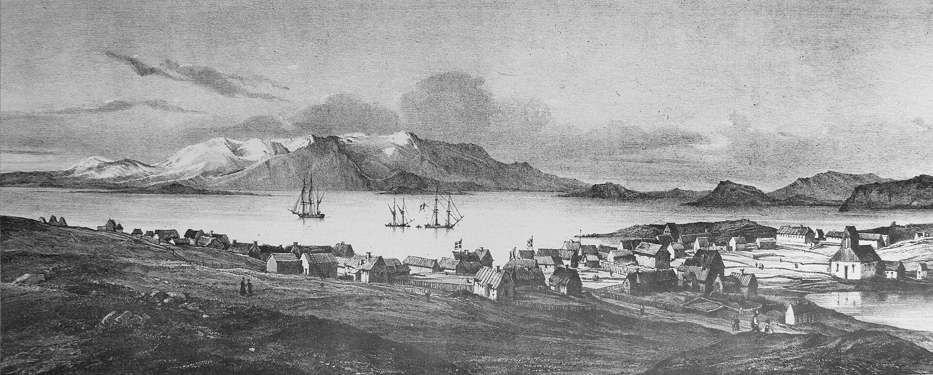
Panorama of Reykjavík taken from the mill, from Gaimard's Voyage en Islande
The turf and timber town lines the shore in a single row of gabled houses, ships riding at anchor in the bay, with Mount Esja and the island of Viðey behind.
1835 · Joseph Paul Gaimard expedition · Wikimedia Commons
Public domain (plate dated 1835)

More cities to explore
 NetherlandsUtrechtExplore it in 1400 · 1700
 EnglandLondonExplore it in AD 200 · 1390 · 1600 · 1885
 FranceParisExplore it in 1250 · 1670 · 1789 · 1889
 GermanyBerlinExplore it in 1750 · 1871 · 1928
Castles of Europe · Landmarks of Europe · create your own reconstruction.