Historic Cities · Ireland
Waterford through the ages
Waterford is a city in County Waterford in the south-east of Ireland. It is located within the province of Munster. The city is situated at the head of Waterford Harbour. It is the oldest and the fifth most populous city in the Republic of Ireland. It is the ninth most populous settlement on the island of Ireland. As of the 2022 census, 60,079 people lived in the city and its suburbs.

Waterford in 1200
The Old Norse Port
This is Waterford shortly after the Anglo‑Norman takeover: an Old Norse trading settlement now governed by new Norman lords, its defences tightened and its quay busier with international ships. The walk follows the walled triangle on the River Suir from the estuary and long quay up past Reginald's Tower, Christ Church and the timber lanes of the old Viking quarter.
In 1200 Waterford reads as a compact, walled triangle of stone and timber pinned to the Suir, its low skyline broken by the round bulk of Reginald's Tower and the squat Romanesque mass of Christ Church. Roofs are thatch, turf and occasional stone slabs; streets are narrow, muddy and flanked by two‑storey timber overhangs and stone storehouses. Ships from Bordeaux and Brittany lie at the long quay, broad‑hulled cogs loading wine, hides and wool beside small clinker fishing boats.
The route: 15 streets, squares and views
Suir Estuary → Long Quay → Hide and Wool Stores → Shipwrights' Yard → Suir Fishing Weirs → Reginald's Tower → City Walls → North Gate → High Street → Market Place → …
Step inside, 8 interiors
Wine Merchant's Undercroft · Tanners' Loft · Shipwright's Shed · Garrison Guard Floor · Covered Market Hall · Norse‑Irish Longhouse · Romanesque Nave · Granary Storage Hall
Planned from the Wikipedia record: History of Waterford.
Its story
The story of Waterford.
Veðrafjǫrðr: the Norse Port on the Suir, 853–1000
The city's name comes from the Old Norse Veðrafjǫrðr, 'ram (wether) fjord'; its Irish name, Port Láirge, means "Lárag's port". Viking raiders first established a settlement near Waterford in 853. That camp, like all the other longphorts, was vacated around 902 when the Vikings were driven out by the native Irish. They re-established themselves in Ireland at Waterford in 914, led at first by Ottir Iarla until 917 and afterwards by Ragnall ua Ímair and the Uí Ímair dynasty, and built what would be Ireland's first city. Among the most prominent of its rulers was Ivar of Waterford, who died in 1000.
The foundation is generally dated to 914, and references to Vikings in the Waterford area survive from 860, 892 and 914. A popular origin story credits a Viking chieftain named Sitric with establishing the place in 853; that account descends from Gerald of Wales and has been challenged by Clare Downham in her article on the historical importance of Viking-Age Waterford. A different origin myth appears in the 13th-century Ystoria Gruffudd ap Cynan, in which the Norwegian king Harald Finehair founds Dublin and gives Waterford to his brother.
During the late 10th and early 11th centuries the rise of Brian Bóruma brought Waterford and other Viking ports firmly under the control of the O'Brien dynasty. Holding these ports mattered to would-be High Kings of Ireland because they granted access to international trade and to manpower. In April 2003 a site at Woodstown near the city was found to combine a fifth-century Iron Age and a ninth-century Viking settlement, and appears to have been a Viking town predating all such settlements in Ireland.
Strongbow's Siege and Henry II's Landing, 1170–1171
Diarmait Mac Murchada, the deposed king of Leinster, failed in an early attempt to take Waterford; he was trying to secure the large centres to advance his claim to the high kingship. He returned in 1170 with Cambro-Norman mercenaries under Richard de Clare, 2nd Earl of Pembroke, known as Strongbow; together they besieged and took the city after a desperate defence. This was the introduction of the Anglo-Normans into Ireland.
In 1171 Henry II of England landed at Waterford with a large fleet, the first English king to set foot in an Irish city. He came to ensure that Ireland became an English colony rather than a rival Norman country. Waterford and Dublin were declared royal cities belonging to the king rather than to Strongbow, and Dublin was declared the capital. Reginald's Tower, built after the invasion on the site of an earlier fortification and keeping its Viking name, was among the first buildings in Ireland to use mortar.
Throughout the medieval period Waterford was Ireland's second city after Dublin. The office of Mayor of Waterford was established in 1377, and the city's great parchment book, kept from 1361 to 1649, represents the earliest use of the English language in Ireland for official purposes. Ballybricken, just outside the walls to the west, is thought to have been Waterford's Irishtown, the kind of settlement that formed outside Irish cities to house Vikings and Irish expelled during the Norman invasion.
Urbs Intacta: the Sieges of Simnel and Warbeck
In the 15th century Waterford repelled sieges by two pretenders to the English throne, Lambert Simnel and Perkin Warbeck. Henry VII rewarded the city with the motto Urbs Intacta Manet Waterfordia: "Waterford remains an untouched city". In the same century the city was enlarged by an outer wall built on the west side. Waterford retains more of its city walls than any other city in Ireland apart from Derry, whose walls were built much later.
A Catholic City Against the State, 1603–1690
Waterford was occupied by Mountjoy in 1603 during the Nine Years' War, the rebellion led by Hugh O'Neill, ostensibly in the cause of Irish independence and the Catholic religion; despite their own Catholicism the townspeople had largely sided with the English government forces. On the coronation of James VI of Scotland as king of England that same year, the citizens joined an uprising common to the coastal cities of Munster and refused entry to Mountjoy, the Lord Deputy, who had just secured O'Neill's surrender. Their motivation lay in a demand for freedom of religion (they were led by Catholic priests and re-consecrated several churches), though there were also mutterings about the new king's nationality. After negotiations Mountjoy was admitted and the citizens pledged their loyalty anew.
Over the following forty years Waterford's Roman Catholic population became deeply alienated from the English Protestant state in Ireland. After the rebellion of 1641 the city was a centre of support for the Confederate Catholics of Ireland, the de facto independent Irish state that fought the Irish Confederate Wars, and it took part in the confederation of Kilkenny that governed from 1642 to 1649. Within the Confederation Waterford was known for militant Catholic politics, rejecting the alliance signed between the Confederates and Charles I that would have sent Irish troops to fight for the king in the English Civil War.
That government was ended by Oliver Cromwell's reconquest. Cromwell's son-in-law Henry Ireton finally took Waterford in 1650 after two major sieges. The population recorded in 1653 was 1,555. In 1690, during the Williamite War, the Jacobite Irish Army was forced to surrender the city in the wake of the Battle of the Boyne.
Newfoundland Trade, Penrose Glass and the Neptune Shipyard, 1700s–1900
The 18th century was a period of great prosperity, and most of the city's best architecture dates from it. Trade with Newfoundland brought wealth into what was then the third largest port in Ireland; the connection outlasted the century, and St John's College, the Catholic seminary founded for the diocese in 1807, established a mission to Newfoundland in the 1830s. In 1783 George and William Penrose founded the glass factory that became Waterford Crystal. A permanent military presence arrived with the completion of the Cavalry Barracks at the end of the century, and in the early 19th century the British government judged the city vulnerable enough to build three Martello towers on the Hook Peninsula to reinforce the existing fort at Duncannon.
Glass making and shipbuilding both thrived in the 19th century. The Malcomson family, owners of the Neptune Shipyard, built and operated the largest fleet of iron steamers in the world between the mid-1850s and the late 1860s, including five trans-Atlantic passenger liners. The prosperity did not hold the city's people: from around 28,000 in the early 19th century the population fell to just over 20,000 by its end, and glass manufacture in the city stopped in 1851, not resuming until 1947. Waterford's population did not climb past 40,000 until the 20th century.
Meagher's Tricolour to the Fall of the City, July 1922
The Irish nationalist Thomas Francis Meagher (Meagher of the Sword) made the first Irish tricolour, brought it back from France, and it was first flown from a building on the Mall in Waterford. From 1891 to 1918 the city was represented in the Parliament of the United Kingdom by John Redmond, who took the seat by defeating David Sheehy and who from January 1900 led the Irish Parliamentary Party, which came close to securing home rule and a new parliament for Ireland.
When British troops evacuated the city at the end of the War of Independence, the military and police barracks were occupied by the Waterford Flying Column under George Lennon of Dungarvan, part of the Waterford Brigade commanded by Pax Whelan. These men opposed the Anglo-Irish Treaty of 1922 and took the Republican side when the Civil War began with the shelling of the Four Courts in late June. Republicans regarded Waterford as the eastern stronghold of the "Munster Republic" and the linchpin of the Limerick–Waterford line.
In late July 1922 National Army troops under Major General John T. Prout (450 men, one 18-pounder and four machine guns) arrived from Kilkenny to retake the city. Prout's second in command was Patrick Paul, formerly commander of the IRA in East Waterford, who had been arrested by his former comrades for supporting the Free State and had escaped disguised as a nun. The Republicans defended the southern bank of the Suir from the military barracks, the prison and the Post Office; Prout placed his gun on Mount Misery and bombarded them until the barracks and prison were abandoned, then brought it down to Ferrybank to fire over open sights before the Post Office was given up. After some street fighting the Republicans retreated westward to Mount Congreve in Kilmeadan. The city fell on 20 July 1922, a day after Limerick. Two Free State soldiers, one Republican fighter and five civilians were killed.
Crystal, Receivership and the Modern City, 1947–2022
Waterford Crystal, made in the city from 1783 to 1851 and again from 1947, became its best-known business and employed thousands in the city and surrounding areas; its cut glass went to New York, where the firm made the 2,668 crystals for the Times Square New Year's Eve ball, and to Westminster Abbey, Windsor Castle and the Kennedy Center in Washington.
The recession from 2008 hit the city hard. The Waterford Crystal factory shut in early 2009 following the receivership of Waterford Wedgwood plc, and other multinationals closed, including Talk Talk; Citibank's hedge fund office remained only until 2013. After intervention by Waterford City Council and the Waterford Chamber of Commerce, a visitor centre opened in the Viking Quarter in June 2010 under new owners and production resumed.
Waterford is the county town of County Waterford and the main city of the South-East Region, and its port is Ireland's closest deep-water port to mainland Europe, handling about 12 per cent of the state's external trade by value. Waterford City and County Council, formed by the merger of the city and county councils, came into operation on 1 June 2014. South East Technological University was established in 2022 from the merger of Waterford Institute of Technology with Institute of Technology, Carlow. At the 2022 census 60,079 people lived in the city and its suburbs.
From the archive
Waterford on paper: the old town as it was mapped.
A period plan or bird's-eye view of the old town, drawn between 1500 and 1850, the streets this page's reconstructions walk. Public domain, with its source named.
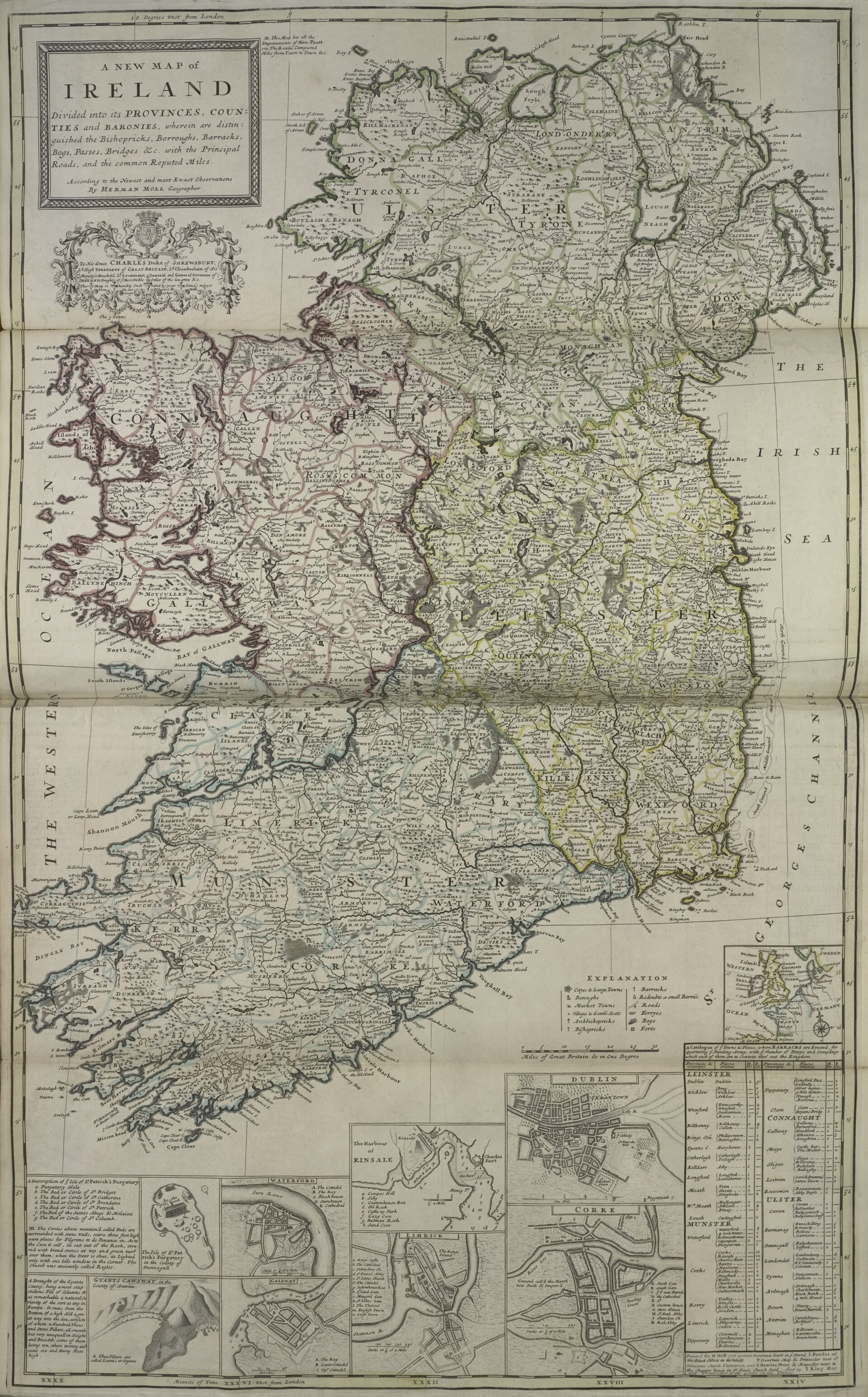
A New Map of Ireland, with inset town plans including Waterford: Herman Moll
Inset town plan of Waterford showing the river mouth and harbour, quays, street blocks and surrounding defensive walls.
1736 · Herman Moll · Wikimedia Commons
CC0 (plate dated 1736)
More cities to explore
 IrelandKilkennyExplore it in 1620
 IrelandCorkExplore it in 1600 · 1880
 IrelandDublinExplore it in 1000 · 1780 · 1904
 IrelandBelfastExplore it in 1800 · 1911
Castles of Europe · Landmarks of Europe · create your own reconstruction.