Historic Cities · Belgium
Ypres through the ages
Ypres is a Belgian city and municipality in the province of West Flanders. Though the Dutch name Ieper is the official one, the city's French name Ypres is most commonly used in English. The municipality comprises the city of Ypres/Ieper and the villages of Boezinge, Brielen, Dikkebus, Elverdinge, Hollebeke, Sint-Jan, Vlamertinge, Voormezele, Zillebeke, and Zuidschote.

Ypres in 1300
Wool Metropolis
At the height of its medieval prosperity, Ypres is a great wool city of tens of thousands, its economy organised around the vast Cloth Hall and the canalised Ieperlee. This walk follows the long arcaded front of the Hall and its belfry, the quays where English wool arrives, the market stalls, the dyeing and fulling workshops that stain the streams, the parish streets and the outer weavers’ terraces.
By 1300 Ypres presents a compact, fortified silhouette: a 125-metre Gothic cloth hall in pale imported stone and a soaring 70-metre belfry rising above a low-rimmed town of steep tiled roofs. Streets are narrow and paved with worn cobbles; canals and streams run bright with tannins where dyers and fullers work. The dominant materials are local and imported sandstone and Tournai blue stone for carved detail; colour comes from stacked woollen bolts, dyed vats and the red-brown roofs of merchant houses.
The route: 16 streets, squares and views
Road to Menen → Menin Gate → South Ramparts → Rijselsepoort (Lille Gate) → Ieperlee Quay → Cloth Hall Water Doors → Cloth Hall Forecourt → Belfry Base → Donkerpoort Passage → Grote Markt Stalls → …
Step inside, 9 interiors
Traveller's Inn Hall · Water-store Chamber · Upper Trading Gallery · Belfry Watch Room · Choir of St Martin · Dyer's Vat-shed · Fuller's Milling Floor · Begijnhof Chapel · Weaver's Loom Room
Planned from the Wikipedia record: Ypres Cloth Hall.
Ypres in 1910
The Quiet Grey Town
This walk shows Ypres in 1910, four years before the Great War, a provincial market town whose medieval monuments tower over hop fields and low domestic roofs. You will move from the river approach and station through gates, ramparts and market streets to the Grote Markt where the Cloth Hall and belfry still define the skyline.
Ypres in 1910 reads as a compact medieval silhouette: the long pitched roof of the Cloth Hall and its belfry, St Martin’s Gothic spire, and a ring of seventeenth‑century ramparts and still moated stretches. Red brick, pale cut stone and grey slate roofs sit above narrow rows of cobbled streets. Domestic doorways spill with lace‑makers and market stalls; bicycles, horse‑drawn hop wagons and peat‑smoke add to the small‑town, workaday palette.
The route: 16 streets, squares and views
Ieperlee Approach → Ieper Station → Rijselpoort → Ramparts Walk → Rijselstraat → Sint‑Pieterskerk → Boterstraat → Vismarkt → Neermarkt → Grote Markt → …
Step inside, 8 interiors
Station booking hall · Ramparts guardroom · Lace makers' workshop · Estaminet zinc counter · Cloth Hall museum gallery · Belfry carillon loft · Cathedral nave of Saint Martin · Almshouse refectory
Planned from the Wikipedia record: Ypres.
Its story
The story of Ypres.
The Ieperlee and the Châtellenie of Ypres
The town is old enough to have been raided by the Romans in the first century BC, but its name enters the record only in 1066, as Iprensis, followed by Ipera between 1070 and 1093 and Ipre regularly through the twelfth century. The name is the river's: a small stream rising near the Kemmelberg was called Ipre or Iepere, the river of elms, from iep, and the settlement founded on its banks took the word from it.
Ypres grew out of two things about 600 metres apart, a Carolingian estate and a market. By the eleventh century they had all but fused into a single burgh where a burgrave governed the châtellenie of Ypres in the name of the Count of Flanders; the earliest known deed to name a castellan of Ypres outright dates from 1109. William of Ypres, born here, led Flemish mercenaries in England and was reckoned among the abler commanders fighting for King Stephen through his nineteen-year war with the Empress Matilda.
Cloth, the Hanse of London and the Cats of the Halle
Ypres made its money from wool. From the early twelfth century its merchants traded with Novgorod, with England, with the fairs of Champagne, with Italy and with the Levant, and for a time the town ranked second in the Flemish Hanse of London. High-quality wool came up the Yser and the Ieperlee from the coast where the sheep were raised; with Arras, Ypres was one of the great centres of the drapery, and through the twelfth century the cloth capital of Flanders. The craft reached its height around 1250. The town had some 40,000 inhabitants by 1200 and was the third city of the County of Flanders after Ghent and Bruges; its linen trade with England was well enough known to be named in the Canterbury Tales.
That weight brought political standing. Ypres sat in the scabini Flandriae, a league of northern towns eventually reduced to four members (Ghent, Bruges, Ypres and the Franc of Bruges), and kept its vote there until 1678. It was drawn into most of the conflicts that shook the county: the Battle of the Golden Spurs, Mons-en-Pévèle, the Peace of Melun and the Battle of Cassel. A major fire ruined much of the old town in 1241. The Cloth Hall, one of the largest commercial buildings of the Middle Ages, was built in the thirteenth century, and it was around then that cats (taken as the sign of the devil and of witchcraft) were thrown from it, possibly to signify that the trading beneath was free of any malign influence; the act is commemorated by the triennial Kattenstoet.
Decline, Plague and the Weavers' Exodus, 1300–1500
The drapery began to slip at the turn of the fourteenth century, as it did across Flanders. Competition from English and Dutch wool, war with France, peasant risings, the great plague of 1347 and repeated dearth pressed the town hard, and during the Norwich Crusade led by the English bishop Henry le Despenser it was besieged and bombarded from May to August 1383 until French relief forces arrived. Manufacturing output fell to half what it had been in 1300, and Ypres proved less able than Bruges to hold on to its markets.
Economic collapse and epidemic together drove most of the working families out of the town in the fifteenth century; plague returned repeatedly between the fourteenth century and the seventeenth. What remained was still a major administrative and hospital centre. The first fortifications appear to date from 1385, and part of that early rampart survives near the Rijselpoort, the Lille Gate.
Iconoclasm, Vauban's Fortress and the End of the Garrison, 1525–1850
The town began to fill again at the end of the fifteenth century as weavers owning their own looms settled in it, bringing with them the inward piety of the devotio moderna. In 1525 the aldermen adopted the poor-relief programme proposed by the philosopher Juan Luis Vives; the Franciscans fought it, but it was upheld by the Sorbonne and by the Emperor Charles V. The first disturbances of the Iconoclastic Fury broke out at Ypres in 1566 and spread rapidly to the northern provinces. The town fell to the Ghent Calvinists in 1577 and the Protestant party held it until Farnese's invasion of 1583. After the destruction of Thérouanne, Ypres became the seat of a new diocese and Saint Martin's was raised to a cathedral; its bishop Cornelius Jansen, whose doctrine is known as Jansenism, died in 1638 during an outbreak of plague while visiting the sick of his diocese.
Whoever held Ypres could watch the whole Flemish coast: Nieuwpoort, Bruges, Ostend, Veurne and above all Dunkirk. The Spanish pulled down the medieval walls and ringed the town with a bastioned enceinte, which did not prevent the French taking it in 1658 and again on 25 March 1678; it stayed French under the Treaty of Nijmegen. Vauban rebuilt the works for a frontier place of the Pré carré, and the town then held a garrison of 5,000 men to which all its manufacture and trade were subordinated, an all but closed economy dependent on the political and military weather.
Under the treaties of Utrecht the Dutch Republic obtained the right of garrison at Ypres and seven other towns, and in 1713 the town passed to the Habsburgs and the Austrian Netherlands. In 1782 Emperor Joseph II ordered parts of the walls torn down, and the damage, only partly repaired, helped the French revolutionary army under Pichegru take the town on 17 June 1794. The enceinte was worked on again from 1816 as part of the Wellington Barrier; when the Belgian revolution came in 1830 the Dutch garrison evacuated on 1 October, three days before independence was declared. In 1850 the Belgian geologist André Dumont named the Ypresian, the earliest age of the Eocene, after the clays of the district.
The Salient, the Gas and the Obliteration, 1914–1918
Ypres lay in the path of the German sweep across Belgium into northern France. Belgian neutrality had been established by the First Treaty of London and guaranteed by Britain, and the invasion brought the British Empire into the war. After the flooding at Nieuwpoort on the Yser front the German army turned its attacks on the Ypres district in October 1914. In the First Battle of Ypres, 19 October to 22 November 1914, the Allies took the town; under German bombardment that November Saint Martin's Cathedral and the belfry of the Cloth Hall burned. The German army then shelled the town from three sides for most of the war, while British, French and allied forces pushed out of the Ypres Salient into their lines at heavy cost.
On 22 April 1915 the German army used poison gas for the first time, opening the Second Battle of Ypres, which ran until 25 May and left them holding the high ground east of the town. The gas was chlorine, and the first attack fell on Canadian, British and French troops, the French contingent including metropolitan soldiers alongside Senegalese and Algerian tirailleurs. Mustard gas, named yperite after the town, was first used near Ypres in the autumn of 1917. The largest and most costly of the battles was the third, from 31 July to 10 November 1917, known as Passchendaele, in which British, Canadian, ANZAC and French forces retook the Passchendaele Ridge; it produced close to half a million casualties on all sides for a few miles of ground. A German offensive in April 1918 was stopped at Merkem by Belgian troops and on the Flanders hills by the British and French, and from September the Allied counter-attack under Foch cleared Belgium.
More than 300,000 Allied soldiers died in the fighting around the town, among them 250,000 from the Commonwealth, and some 170 military cemeteries lie in the countryside around it, the largest at Tyne Cot and at the German cemetery at Langemark. By the end the medieval town had been almost entirely destroyed by artillery. English-speaking soldiers called the place "Wipers", a deliberate mispronunciation applied to other Flemish names nearby (Wytschaete became "White Sheet", Ploegsteert "Plug Street"), and British troops published a trench newspaper called The Wipers Times.
Exile at Le Touquet and the Argument Over the Ruins, 1915–1929
The civilian town went into exile. On 15 February 1915 the Franco-Belgian refugee committee at Le Touquet-Paris-Plage in the Pas-de-Calais listed 49 refugee families from Ypres, and in May 1915 the burgomaster René Colaert settled there and went on administering his city with his aldermen, organising schooling for hundreds of children and relief for the refugees. On 23 February 1919, unable to meet in Belgium, the council of Ypres sat in the town hall of Le Touquet from nine in the morning until seven at night to discuss the rebuilding of the city.
What to do with the ruins was fought over. Winston Churchill proposed leaving Ypres as a mausoleum, with the rightful owners deprived of any claim to regain their land, and by early March 1919 the Belgian plan was to leave the cathedral, the Cloth Hall and the buildings around them in ruins. In early September 1920 the British government settled on the Menin Gate and its immediate surroundings as the memorial site; by then the Belgians had already begun rebuilding.
The town was decorated with the Croix de Guerre on 22 October 1919. On 12 February 1920 King George V awarded it the Military Cross, one of only two such awards to a municipality in the First World War, the other being Verdun; it was added to the city's arms in 1925. British veterans founded the Ypres League in the 1920s and made the town the symbol of everything they believed Britain had fought for; Lieutenant-Colonel Beckles Willson's 1920 guidebook was called The Holy Ground of British Arms, and Britons came on pilgrimage. The Menin Gate Memorial to the Missing, designed by Sir Reginald Blomfield, was unveiled by Lord Plumer on 24 July 1927; it names Commonwealth dead who fell in the Salient before 16 August 1917 and have no known grave, and names are struck from it as graves are identified. The Last Post has been sounded beneath it every evening at eight since 1929.
Occupation, Liberation and the Copied Town, 1940–Present
The German offensive of 10 May 1940 reached Ypres quickly. On 21 May General Weygand met King Leopold III of the Belgians and General Gaston Billotte in the town; the meeting altered nothing, and Billotte was killed in a car accident at Ypres on 23 May. Belgium capitulated on 28 May. The British Expeditionary Force fought a delaying action at the Ypres–Comines Canal, one of the engagements that allowed the withdrawal to Dunkirk. Adolf Hitler, who had fought at Ypres in the First World War, visited the town in 1940. The occupying forces banned the Last Post; from January 1941 until the liberation it was sounded daily at Brookwood Military Cemetery in England instead. On 6 September 1944 the 1st Polish Armoured Division liberated Ypres, and the ceremony resumed at the Menin Gate that same evening, with fighting still going on elsewhere in the town.
Reconstruction was paid for out of German reparations. The Grote Markt, including the Cloth Hall and the town hall, was rebuilt as closely as possible to the original designs; the Cloth Hall standing today is an exact copy of the medieval building, and the complex was designated a UNESCO World Heritage Site in 1999. Saint Martin's, first built in 1221, was also entirely reconstructed, though with a taller spire than before; it holds the tombs of Jansenius and of Robert of Bethune, called the Lion of Flanders, Count of Flanders from 1305 to 1322.
The municipality covers 131.45 square kilometres and takes in ten surrounding villages alongside the city itself; together they hold about 34,900 people, and Ypres is the seat of its arrondissement. The Cloth Hall now houses the In Flanders Fields Museum, named after John McCrae's poem, and the town hosts the international campaign secretariat of Mayors for Peace.
From the archive
Ypres on paper: the old town as it was mapped.
A period plan or bird's-eye view of the old town, drawn between 1500 and 1850, the streets this page's reconstructions walk. Public domain, with its source named.
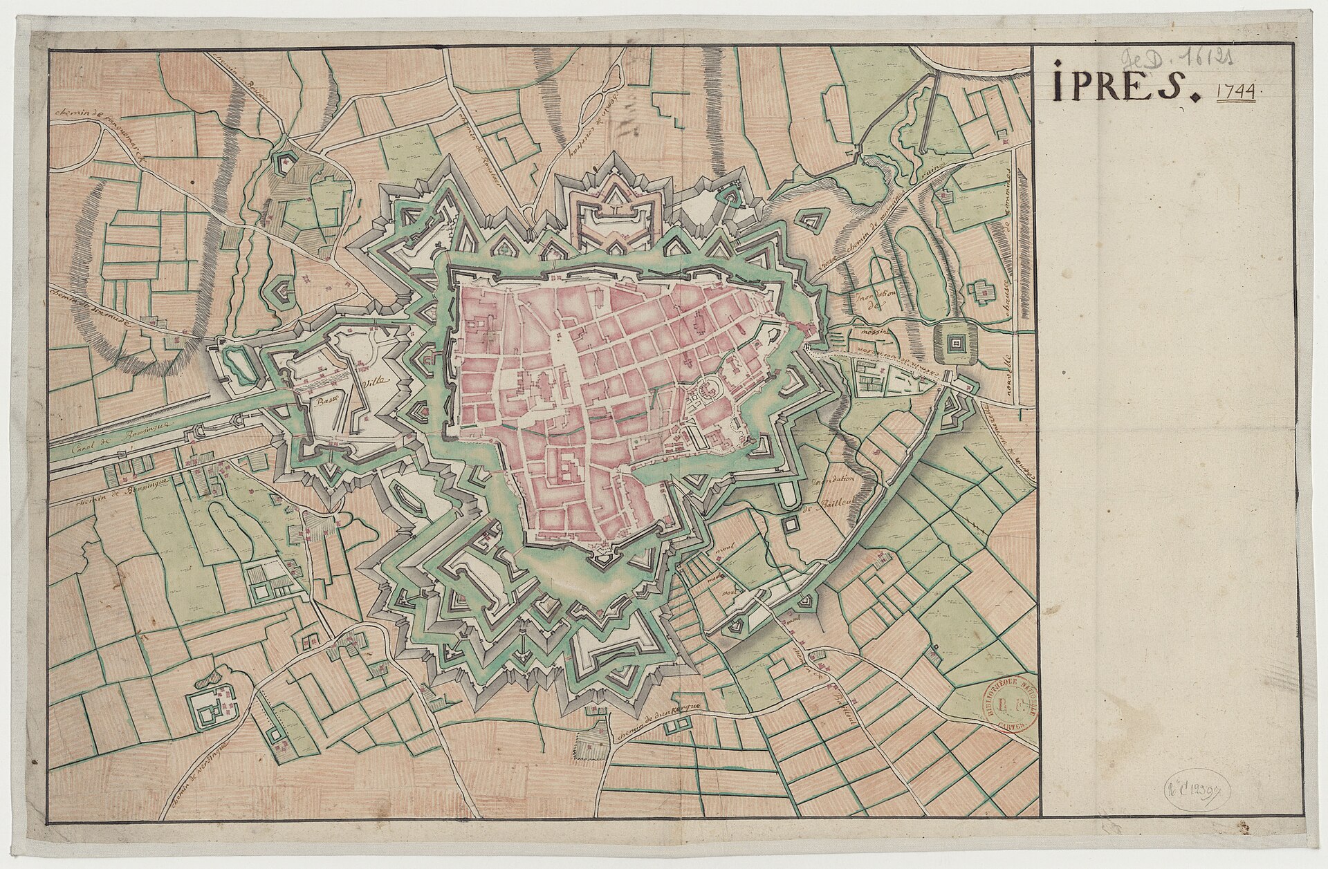
Plan of Ipres (Ypres), 1744
Top-down plan showing Ypres’s bastioned ramparts and glacis, surrounding moats/canals, the inner street grid and several prominent churches and gates.
1744 · Wikimedia Commons
Public domain (plate dated 1744)

More cities to explore
 BelgiumBrugesExplore it in 1300 · 1440 · 1895
 BelgiumGhentExplore it in 1350 · 1913
 BelgiumBrusselsExplore it in 1560 · 1700 · 1900
 BelgiumAntwerpExplore it in 1560 · 1910
Castles of Europe · Landmarks of Europe · create your own reconstruction.