Historic Cities · Scotland
Aberdeen through the ages
Aberdeen is a port city in North East Scotland, and is the third most populous Scottish city. Historically, Aberdeen was within the historic county of Aberdeenshire, but is now separate from the council area of Aberdeenshire. Aberdeen City Council is one of Scotland's 32 local authorities.

Aberdeen in 1500
Burgh of Aberdeen
Aberdeen in 1500 is a pair of neighbouring burghs: New Aberdeen around the Dee estuary and Old Aberdeen at the mouth of the Don, with the newly founded King's College rising beside the cathedral. The walk moves from the harbour and Castlegate through markets, quays and streets to the college and St Machar's cathedral, ending on a high viewpoint that looks over both rivers and the coastal approaches.
Two compact burghs cling to the mouths of the Dee and Don: low stone and timber houses with slate and thatch roofs, narrow cobbled lanes, and the occasional town wall or gate. Small sailing cogs and fishing boats crowd the harbour by a recent blockhouse; Baltic traders unload barrels and hemp. The Castlegate market, the tolbooth and mercat cross mark the burgh centre, while across the Don the stone towers of St Machar and the crown tower of King's College punctuate the skyline.
The route: 21 streets, squares and views
Mouth of the Dee → Harbour Blockhouse → Shiprow Quay → Castlegate → Mercat Cross → The Tolbooth → Kirk of St Nicholas → Upperkirkgate → The Green → Fishmarket → …
Step inside, 13 interiors
Blockhouse Guardroom · Hanseatic Warehouse · Merchant's Counting-house · Tolbooth Council Chamber · St Nicholas Nave · Fishmarket Hall · Butchers' Great Hall · Bridge Toll Chamber · Salmon-net Loft · St Machar's Nave · King's College Chapel · College Hall · Burgess's Timber Hall
Planned from the Wikipedia record: History of Aberdeen.
Aberdeen in 1880
The Granite City
Aberdeen in 1880 is a prosperous, late‑Victorian port city remade in local grey granite and linked by new streets and railway. The walk moves from the North Sea and busy harbour through Union Street's mile of terraces, past Marischal College and municipal buildings, to the quarry and Old Aberdeen, showing ships, fish markets, quays and the everyday labour that keeps a northern port alive.
A compact skyline of glittering grey: long terraces and civic blocks of local granite, pierced by church spires and the square tower of King's College, sit behind rows of masts and steam funnels in the harbour. Union Street cuts a straight, elevated mile across the city, its parapets and arches shining after rain; the Denburn drops beneath in a deep, shadowed ravine. Rubislaw quarry yawns as a raw hole in the western ridge; gulls, coal smoke and the bright canvas of sailing clippers shape the sound and colour of the port.
The route: 22 streets, squares and views
North Sea Approach → North Pier → South Breakwater → Victoria Dock → Footdee (Fittie) → Shiprow → Harbour Fish Market → Bridge of Dee → Torry Harbour → Torry Battery → …
Step inside, 13 interiors
Harbour Master's Office · Shipwright's Loft · Covered Fishmarket Hall · Bridge Tollhouse Room · Torry Fisher Family Kitchen · Railway Booking Hall · Granite Merchant Showroom · Arched Workshop Under Bridge · Marischal College Hall · Town House Council Chamber · Music Hall Auditorium · Infirmary Male Ward · Granite Polishing Shed
Planned from the Wikipedia record: History of Aberdeen.
Its story
The story of Aberdeen.
Two Burghs at Two River Mouths
The area has seen human settlement for at least 8,000 years, beginning with hunter-gatherers who established themselves around 6000 BC at the mouths of the Dee and the Don. The name is recorded as Aberdon in 1172 and Aberden in about 1180: the first element is the Pictish word aber, 'river mouth', and the second derives from the Celtic river goddess Devona. The place is usually described as lying within historic Pictish territory.
The city grew up as two separate burghs. Old Aberdeen, at the mouth of the Don, was the cathedral and university settlement; New Aberdeen, where the Denburn entered the Dee estuary, was a fishing and trading town. Old Aberdeen's first church was built around 580, after St Kentigern sent St Machar to convert the Picts, and St Machar's Cathedral carries his name. It became the seat of the Bishopric of Aberdeen once David I transferred the pre-Reformation diocese from Mortlach in Banffshire to Old Aberdeen in 1137.
David I began the development of New Aberdeen north of the Dee in 1136, the year the harbour was established. Aberdeen's oldest surviving charter was granted by William the Lion about 1179, confirming the corporate rights David I had given and with them trade privileges for the burgesses. In 1214 Alexander II granted the burgesses the sole right to form a Guild, a body that exercised power in the composition of the council and in the affairs of the town, and remained an integral part of the council for more than 700 years.
Bruce's Great Charter, 1319
During the Wars of Scottish Independence Aberdeen was under English rule. After William Wallace was executed in 1305 his body was cut up and sent to different corners of the country to warn other dissenters; his left quarter ended up in Aberdeen and is buried in the walls of the cathedral. Robert the Bruce laid siege to Aberdeen Castle, destroyed it in 1308 and executed the English garrison.
In 1319 the Great Charter of Robert the Bruce transformed Aberdeen into a property-owning and financially independent community. With it came the nearby Forest of Stocket, whose income formed the basis of the city's Common Good Fund, still used for the benefit of Aberdonians. Bruce had a high regard for townspeople who had sheltered him during his outlawry, helped him win the Battle of Barra and killed the English garrison at the castle. The city's motto, Bon Accord, is French for 'Good Agreement'; legend has it the words were a password used by Bruce's men at the siege.
The Council Registers and Two Colleges, 1398–1593
Aberdeen's medieval council registers, then known as the common books, survive from 1398 onwards and are exceptional for their quantity and continuity among surviving Scottish burgh records. The earliest eight volumes, covering 1398 to 1511, are on the UNESCO UK Memory of the World Register and have been edited in a digital edition. They record a small town: the population in 1396 was about 3,000.
Old Aberdeen was burned by Edward III of England in 1336, but was soon rebuilt and extended. For many centuries the city was subject to attack by neighbouring lords and was strongly fortified, though the gates were all removed by 1770; in 1497 a blockhouse was built at the harbour mouth as protection against the English. Royal charters of 1489 and 1498 created a free burgh to be administered by the church, and Old Aberdeen was made a separate burgh in 1489.
King's College was founded in Old Aberdeen in 1495 by William Elphinstone (1431–1514), Bishop of Aberdeen and Chancellor of Scotland; in 1593 George Keith, fifth Earl Marischal of Scotland, founded Marischal College as a separate institution in New Aberdeen. The two were merged by the Universities (Scotland) Act 1858 to form the University of Aberdeen, the fifth oldest in the English-speaking world. Building work on St Machar's Cathedral had crept along apart from Elphinstone's episcopate of 1484 to 1511, and was finished by Gavin Dunbar, who followed him in 1518 and added the two western spires and the southern transept.
Sacked in 1644, Plague and the Seven Ill Years
During the Wars of the Three Kingdoms of 1644 to 1647 the city was plundered impartially by Royalists and Covenanters alike. In 1644 it was taken and sacked by Royalist troops, made up of Irishmen and Highlanders, after the Battle of Aberdeen; between 118 and 160 people were killed. The sack, under the Royalist general Montrose, involved large-scale rape, uncharacteristically for the period. Two years later the city was stormed by a Royalist force under George Gordon, 2nd Marquess of Huntly.
Bubonic plague broke out in 1647 and killed a quarter of the population. A further outbreak over 1687 and 1688 killed 8.5 per cent, adding to the economic and demographic damage the wars had already done. In the 1690s, during the Seven Ill Years, up to a quarter of the population of Aberdeenshire died of starvation. In 1715 the Earl Marischal proclaimed the Old Pretender at Aberdeen; in 1745 the Duke of Cumberland lodged in the city for a short time before moving against the Young Pretender.
Union Street and the Bankruptcy of 1817
The eighteenth century brought a new town hall and the city's first social services, an infirmary at Woolmanhill and a lunatic asylum. Late in the century the council embarked on a scheme of road improvements, and by 1805 George Street, King Street and Union Street were open; Union Street alone took the partial levelling of St Catherine's Hill and a single 130-foot span across the Denburn Valley. Along the new streets rose the nucleus of the Granite City, many of its buildings designed by John Smith and Archibald Simpson.
The building programme was ruinous, and in 1817 the town council went bankrupt. A police commission, 'police' here meaning civic government rather than law enforcement, had first been set up in 1795 with powers to levy taxes and provide infrastructure; short-lived at first, it was resurrected in 1818 after the bankruptcy, and from then until 1871 Aberdeen was run under a dual system of council and commission.
Prosperity returned with the general recovery that followed the Napoleonic Wars. Grey granite was quarried at Rubislaw for more than 300 years and used for paving setts, kerbs, building stone and monumental work; Aberdeen granite went into the terraces of the Houses of Parliament and Waterloo Bridge in London. Quarrying there finally ceased in 1971.
Harbour, Railway and the City of 1891
The growth of shipbuilding and fishing made the old harbour inadequate, and much of the harbour as it stands today was built during the nineteenth century: Thomas Telford's extension to the North Pier between 1810 and 1815, Victoria Dock completed in 1848, and the South Breakwater. Gas street lighting arrived in 1824 and an underground sewerage system was begun in 1865. The Great North of Scotland Railway was formed in 1846 with its headquarters at 89 Guild Street, and became one of the constituents of the London and North Eastern Railway in 1923.
The Aberdeen United Trades Council, established in 1868, became a prominent force in the city, sponsoring candidates for the council and campaigning for shorter working hours. Between 1801 and 1901 the population rose from 26,992 to 153,503. In 1891 the boundaries were significantly enlarged, absorbing the neighbouring burghs of Old Aberdeen and Woodside together with Torry on the south bank of the Dee; the same act of parliament confirmed that Aberdeen was entitled to be called a city, which it had commonly been described as before but, like most Scottish cities, without official recognition. In 1899 it was separated from the county of Aberdeenshire and made a county of a city.
Trawlers, the Raid of 21 April 1943 and North Sea Oil
Local entrepreneurs launched the first steam-powered trawler in the nineteenth century, and steam trawling expanded until, by 1933, Aberdeen was Scotland's top fishing port, employing nearly 3,000 men with 300 vessels sailing from its harbour. Over the course of the Second World War the city was attacked 32 times by the Luftwaffe. One of the most devastating attacks came on Wednesday 21 April 1943, when 29 Dornier 217s flying from Stavanger in Norway attacked between 22:17 and 23:04; 98 civilians and 27 servicemen were killed and 12,000 houses damaged by a mixture of incendiary, high-explosive and cluster bombs. Work published in 2018 and 2022 using bombing records held in London identified unexploded bombs from the raid found in the 1950s and 1980s, bringing the total dropped that night to 129.
In 1964 a typhoid outbreak, with about 400 cases and three deaths, was traced to contaminated meat sold by a shop on Union Street; the report of the government enquiry is known as the Milne Report. Geologists had speculated about oil and gas in the North Sea since the middle of the century, but exploration only began in the 1960s, and the first major find in the British sector came in November 1970 in the Forties field, 110 miles east of Aberdeen. By late 1975 the infrastructure was in place and oil was flowing through the Forties pipeline system to the refinery at Grangemouth. Much of the trawling fleet had relocated to Peterhead by the time oil came on stream, and the older trades followed: paper-making, first recorded in the city in 1694, contracted with mill closures in 2001 and 2005, and textile production ended when Richards of Aberdeen closed in 2004.
The offshore industry brought its own disasters. In 1988 the Piper Alpha platform, 190 km north-east of the city, exploded and collapsed, killing 165 in what remains the worst offshore oil and gas accident in terms of lives lost. In 2009 a helicopter returning from a platform to Aberdeen Airport crashed 20 km north-east of Peterhead, killing all 16 on board; Hazlehead Park holds a memorial to the Piper Alpha crew, and Johnston Gardens a memorial to those lost in the crash. Counties of cities were abolished in 1975, and the reforms of 1996 left the city as the unitary council area of Aberdeen City, one of Scotland's 32 councils, with an estimated population of 231,780 in 2024; as North Sea reserves decline it has worked to recast itself as an energy capital rather than an oil capital.
From the archive
Aberdeen on paper: the old town as it was mapped.
A period plan or bird's-eye view of the old town, drawn between 1500 and 1850, the streets this page's reconstructions walk. Public domain, with its source named.
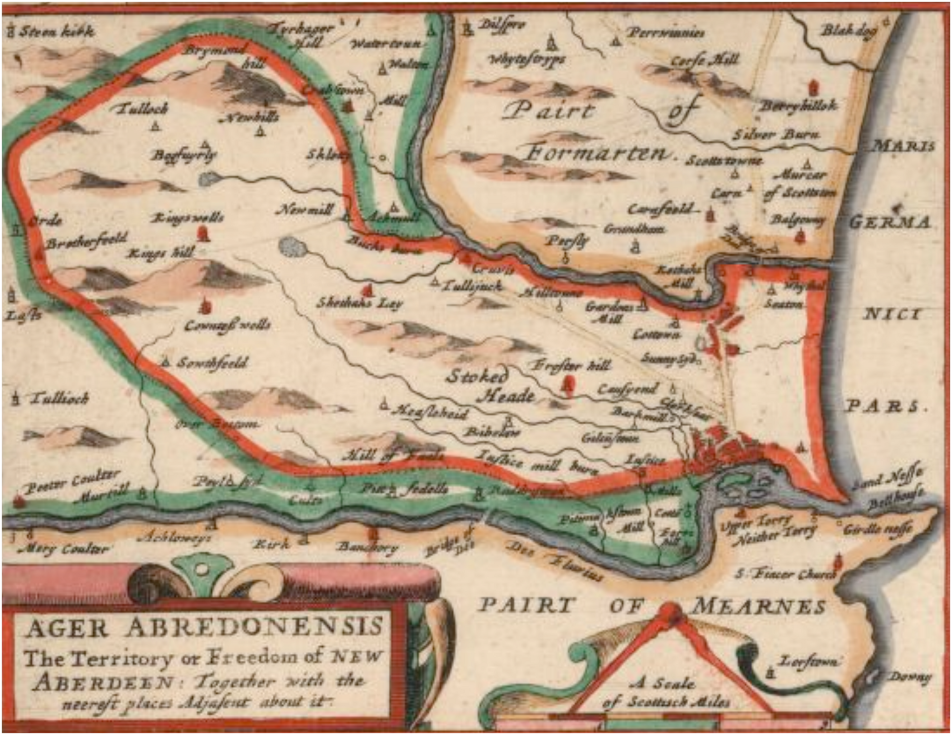
Bird's-eye view of Aberdeen, from James Gordon's Ager Abredoniensis (1661)
Depicts Aberdeen’s old town and New Town with streets and blocks, the River Dee and harbour, the Castlegate and castle, named churches and gates, and the coastal Lynks sandspit.
1661 · Thincat · Wikimedia Commons
Public domain (plate dated 1661)

Castles of Aberdeen

More cities to explore
 ScotlandSt AndrewsExplore it in 1450 · 1900
 ScotlandInvernessExplore it in 1560 · 1880
 ScotlandEdinburghExplore it in 1560 · 1790 · 1880
 ScotlandGlasgowExplore it in 1650 · 1775 · 1888
Castles of Europe · Landmarks of Europe · create your own reconstruction.