Historic Cities · Scotland
Glasgow through the ages
Glasgow is the most populous city in Scotland, located on the banks of the River Clyde in west central Scotland. It is the third-most populous city in the United Kingdom and the 27th-most populous city in Europe, and comprises 23 wards which represent the areas within the city boundaries.

Glasgow in 1650
Cathedral-town Glasgow
Glasgow in 1650 is a compact medieval bishopric clustered around the stone mass of the cathedral and the High Street collegiate precinct. The walk threads riverside quays, crowded market streets, the tolbooth and college approaches, and the bishop's castle before rising to a broad hilltop view over the Clyde and surrounding farmland.
The skyline is dominated by the vaulted silhouette of Glasgow Cathedral and the squat keep of the bishop's castle; the rest of the town is a tight cluster of two‑ and three‑storey timber and stone houses with steep, often thatched or pantiled roofs. Streets are narrow, broken by closes and wynds, with open market spaces, timber stalls, exposed millwheels on the Molendinar Burn and small clinker boats at quays on the muddy Clyde.
The route: 21 streets, squares and views
River Clyde (approach) → Saltmarket Quay → Glasgow Green → Bridgegate → Saltmarket → Candleriggs → Trongate → Mercat Cross → Glasgow Tolbooth → High Street (north) → …
Step inside, 13 interiors
Fishmongers' Salt Cellar · Meatmarket Great Hall · Linen Dyers' Workshop · Burgh Council Chamber · Tolbooth Prison Vaults · Arcaded Inner Court · Tutor's Private Study · Scholars' Hall · Bishop's Great Hall · Choir Stall and Quire · Laigh Parish Crypt · Miller's Wheelroom and Store · Merchant's Booth Interior
Planned from the Wikipedia record: History of Glasgow.
Glasgow in 1775
Tobacco lords' Glasgow
This walk visits Glasgow at the height of the tobacco boom, when merchant fortunes and Atlantic ships reshaped the riverfront and the city's westward streets. You will see the coal-dark Clyde crowded with tall ships, the merchants' classical churches and townhouses, and the plainstanes and markets where work and credit met the planter economies of Virginia and Maryland.
In 1775 Glasgow's silhouette is low and horizontal, punctured by a few classical church towers and the Tolbooth steeple; rows of stone townhouses and newly laid town streets step back from the Clyde. The river is busy with deep-drafted Atlantic tobacco ships, timbered wharves and rope‑walks, while streets are surfaced with plainstanes and edged with sandstone facades, mahogany coaches, black‑silk coats set off by scarlet cloaks, and the constant dust and smoke of a bustling port.
The route: 22 streets, squares and views
River Clyde Approach → Broomielaw Quay → Clyde Warehouses → Shipwrights' Yard → Saltmarket → Trongate Plainstanes → Trongate → Glasgow Cross → Tolbooth Steeple → Tron Steeple → …
Step inside, 12 interiors
Quay Counting House · Riverside Tobacco Vault · Cooperage · Master Shipwright's Workshop · Council Chamber · Kirk Gallery · Choir Aisle · Parish Nave · Merchant Stair Hall · West Drawing Room · Merchant's Study · Great Saloon
Planned from the Wikipedia record: Tobacco Lords.
Glasgow in 1888
Second city of the Empire
Glasgow in 1888 is the great industrial and mercantile city now often called the 'Second City of the Empire': a place of shipyard cranes along the Clyde, new municipal grandeur at George Square, and a popular International Exhibition in Kelvingrove Park. This walk moves from the river's working waterfront through the commercial streets and emerging West End to a high riverside vantage, showing the city's shipbuilding, shops, public life and the spectacle of the exhibition.
The skyline is a layered silhouette of church spires, the new Gothic towers of the University, and numerous iron shipyard cranes along the Clyde, belching steam and coal smoke. Streets are stone- and cobble-paved, flanked by sandstone warehouses, merchant houses and newly ornate civic façades in carved stone. Gas lamps and horse-drawn trams thread crowds of top-hatted merchants, cloak- and bustled ladies, dockworkers and tradesmen, with a thin north-west light and frequent river mist softening distant forms.
The route: 21 streets, squares and views
Govan Waterfront Approach → Fairfield Shipyard, Govan → Finnieston Quay → Anderston Quays → The Broomielaw Quay → Jamaica Street Basin → St Enoch Square → Argyle Street → Buchanan Street → Sauchiehall Street → …
Step inside, 14 interiors
Fairfield Engine Shop · Warehouse Counting House · Customs Office Counting Room · Exchange Trading Room · Sauchiehall Tearoom · Marble Staircase and Vestibule · Trades Hall Assembly Room · Textile Counting Room · Cathedral Nave · Saltmarket Meat Market Hall · Hunterian Museum Gallery · Exhibition Machinery Hall · Exhibition Refreshment Salon · Kibble Palace Conservatory
Planned from the Wikipedia record: History of Glasgow.
Its story
The story of Glasgow.
The Lowest Ford on the Clyde
Glasgow sits at the furthest downstream fording point of the River Clyde, where the Molendinar Burn joins it, and the site has been settled since prehistoric times. The Romans built outposts in the area and ran the Antonine Wall across the country to keep Roman Britannia separate from the Brittonic-speaking Caledonians to the north. After the Roman withdrawal the settlement lay within the Kingdom of Strathclyde, whose capital was at Dumbarton some 24 kilometres downriver, and which merged with other regions in the 9th century to form the united Kingdom of Scotland.
The name is Brittonic: glas, "grey-green" or "grey-blue", with a second element meaning "hollow". It is often said instead to mean "dear green place", which remains an affectionate name for the city, though the modern Gaelic Glaschu descends from the same Brittonic roots. It is recorded that Rhydderch Hael, king of Strathclyde, welcomed Saint Kentigern (Saint Mungo), and procured his consecration as bishop in about 540, and that Kentigern worked in the region for some thirteen years, building his church at the Molendinar Burn where the cathedral now stands. The community that grew around him became known as Glasgu, a name first recorded in 1116.
Bishopric, Bridge and the University of 1451
Glasgow's standing as a city derives from its medieval position as Scotland's second largest bishopric, which grew in importance through the 10th and 11th centuries as it was reorganised under King David I and John, Bishop of Glasgow. The first stone cathedral was consecrated in about 1136 and replaced by a larger one consecrated in 1197; it was the seat of the bishops and, after 1472, the archbishops. The Glasgow Fair reportedly began in 1190. A bridge across the Clyde is recorded from around 1285, as the lowest bridging point on the river it was an important crossing, and the district beside it became the Briggait. By the fifteenth century the built-up area ran from the cathedral down High Street, Saltmarket and Bridgegate to the water, crossing the east-west road at Glasgow Cross, which became the commercial centre.
The University of Glasgow was founded by papal bull in 1451 in religious buildings within the cathedral precincts, and the elevation of the bishopric to an archdiocese in 1492 added further to the town's landed wealth. After the Reformation of 1560 the Catholic rituals ended and statues and symbols were removed or painted over, and the cathedral was divided between three Presbyterian congregations at once. In 1605 the fourteen incorporated trade crafts federated as the Glasgow Trades House to match the influence of the merchants, who founded their Merchants House the same year; in 1611 Glasgow was raised to royal burgh. Daniel Defoe, visiting in the early eighteenth century, called it "the cleanest and beautifullest, and best built city in Britain, London excepted"; its population was then about 12,000.
Tobacco, Sugar, Slavery and Linen
Early trade was in agriculture, brewing and fishing, with cured salmon and herring going to Europe and the Mediterranean. Because the river below the city was too shallow for seagoing merchant ships, the magistrates created a new town and deep-water port at Port Glasgow, some 32 kilometres downstream, from 1668. Scottish trade with the English colonies was proscribed by the Navigation Acts of 1651, and the attempt to found a Scottish colony at Darien ended in disaster and bankrupted the country in 1700; merchants carried on small-scale smuggling until the Union of 1707 made the traffic legal.
What followed was built on slave-produced cash crops (American tobacco and cotton, Caribbean sugar) imported to the Clyde and re-exported across Europe. By 1760 Glasgow had overtaken London as the main tobacco port in the Kingdom of Great Britain, and by the late eighteenth century more than half of the British tobacco trade was concentrated on the river, over 47 million pounds of leaf a year at its peak. Between 1717 and 1766 Scottish slave ships working mainly out of Greenock and Port Glasgow carried around 3,000 enslaved Africans to the Americas, of roughly 5,000 carried by Scottish ships altogether. The merchants known as the Tobacco Lords, enriched by the trade and by direct slave ownership, took up the lifestyle of the landed gentry, spent heavily on houses and churches, and reinvested in industry. The American War of Independence ended most of the American trade, which never recovered to a quarter of its former volume; the merchants turned to the British West Indies and to textiles.
Textiles carried the city in their own right. Linen was employing about 12,000 people in the Glasgow area by 1680 and was pushed hard by government acts and tax measures, so that by 1770 Glasgow had become the largest linen manufacturer in Britain. As tastes shifted to lighter fabrics Scottish linen could not compete on quality, and manufacturers turned to fine cotton muslins, challenging the Indian muslins traded by the East India Company by the 1780s. Linens and clothing were among Scotland's main exports to the tobacco colonies from the 1720s.
Clyde-Built, 1770s–1900
De-silting the Clyde in the 1770s let bigger ships come further up the river, and successive dredging works made shipbuilding possible on the upper reaches. The Monkland Canal and its basin, linked to the Forth and Clyde Canal at Port Dundas in 1795, opened the Lanarkshire coal and iron-ore fields to the city. Ironstone was discovered within those coalfields in 1801, the hot-blast furnace was invented in 1828, and steelmaking followed; coal and iron turned Glasgow into an industrial city, with cotton and wool mills as large employers across the region.
Shipbuilding on Clydeside began with small yards, the first opened in 1712 at the Scott family's yard at Greenock. After 1860 the Clyde yards specialised in iron steamships, and from 1870 steel ones, which rapidly displaced the wooden sailing ships of the world's merchant and battle fleets; the river became the pre-eminent shipbuilding centre in the world, "Clydebuilt" became a benchmark of quality, and the yards took warship contracts too. Shipping lines including Cunard, Union-Castle and Clan Line were founded here, and the city became the largest centre of locomotive building in Europe. By the end of the nineteenth century (despite the collapse of the City of Glasgow Bank in 1878) it was producing more than half of Britain's tonnage of shipping and a quarter of all the locomotives in the world, and was among the cities called the "Second City of the Empire", a title Liverpool, Dublin and others also claimed.
From 32,000 to a Million: Cholera, Water and Newcomers
Glasgow held 32,000 people in 1750 and 200,000 by 1850; its population passed Edinburgh's by 1821, and it became one of the first cities in Europe to reach a million. Town planning began in earnest around 1770 under James Barrie, who laid out a grid above Ingram Street in 1772, but building never kept pace and conditions in the overcrowded slums were notoriously bad. In the early nineteenth century an eighth of the people lived in a single room. Some 4,000 died in the cholera outbreak of 1848–49; the answer was the Corporation's scheme to raise Loch Katrine and bring clean water 42 kilometres by gravity into the city, opened by Queen Victoria in 1859.
The people who filled the city came from the Lowlands and Highlands, from elsewhere in Britain and from the Continent, but the great majority of those from outside Scotland came from Ireland, above all from Donegal, Fermanagh, Tyrone and Londonderry. In the 1881 census 13 per cent of the population had been born in Ireland; by 1911 the city had stopped gaining people by migration, and the 1951 census recorded 93 per cent Scottish-born. Lithuanian refugees began settling in the early twentieth century and numbered around 10,000 in the Glasgow area at their height in the 1950s. Italian families arrived from provinces such as Frosinone in Lazio and Lucca in Tuscany. The Jewish population was once second in size only to London's, estimated at 20,000 in the Gorbals alone; by 2016 it was the seventh largest in the United Kingdom.
Red Clydeside and the Clydebank Blitz
The First World War brought large contracts to the shipbuilders even as their most skilled men went into the services. Glasgow raised 28 new battalions, and about 18,000 of its soldiers were lost. Women took jobs in the yards and munitions factories; in 1917 King George V presented an OBE to the munitions worker Lizzie Robertson at a ceremony in Ibrox Stadium, cheered by other women of the trade. Others served abroad with the Scottish Women's Hospitals for Foreign Service, among them the Maryhill nurse Louisa Jordan, posted to Serbia.
The war also produced the radical movement known as Red Clydeside, led by militant trade unionists, with repeated strikes by the Shop Stewards' Movement, whose Clydeside leader Willie Gallacher took West Fife in 1935 as the only Communist MP to sit in the Commons. The industrial districts, once a Liberal stronghold, went over to Labour by 1922 on a base in the Irish Catholic working-class districts, with women particularly active over housing. By the late 1920s the mood had turned to passive despair, and Glasgow did not escape the Great Depression. The outbreak of war in 1939 halted the decline for a time, with the yards and heavy industries working at capacity, at the cost of Luftwaffe bombing of Clydeside, the worst of it the Clydebank Blitz of March 1941, aimed at the shipbuilding town just outside the city boundary.
The Bruce Report, the New Towns and What Came After
As the war ended, Robert Bruce, chief engineer of Glasgow Corporation, published the first of two studies on regenerating the city without the heavy industries that had made it rich. The Bruce Report proposed depopulating the crowded centre and dispersing people outwards, and although its more radical demolitions were rejected, its housing and transport proposals were followed almost to the letter. The rival Clyde Valley Regional Plan of 1946, by a team under Sir Patrick Abercrombie and Robert H. Matthew, argued instead for rehousing much of the population in new towns beyond the boundary. A blend of the two was carried out: the tenement slums, many already destroyed or damaged by bombing, gave way to high-rise blocks and peripheral estates, while thousands moved out to Cumbernauld, East Kilbride, Livingston, Glenrothes and Irvine. The city area held some 1,089,000 people in the 1950s and 593,245 by 2011.
The industry went too. Cheap labour abroad and new shipbuilding powers such as Japan undercut the yards, and the major Clyde builders closed, though not before Clydebank completed Cunard's Queen Elizabeth 2. Containerised freight ended the riverside docks and wharves, which had fallen derelict by the late 1960s. Steelworks, coal mines and engine factories went out of business through the 1970s and early 1980s, leaving mass unemployment and urban decay, and by the end of the 1970s the estates built barely a decade before were themselves sliding. The Glasgow Eastern Area Renewal initiative of 1977 began refurbishing inter-war and historic tenement housing instead of demolishing it.
From the mid-1980s the direction changed. Soot was blasted off the tenements and municipal buildings, surviving flats were refurbished as private housing, and a financial district rose at the west end of the centre, its service sector growing 30 per cent between 1998 and 2001. The "Glasgow's Miles Better" campaign of 1983 was followed by the Burrell Collection the same year, the Scottish Exhibition and Conference Centre in 1985, the National Garden Festival at Prince's Dock in 1988, and European City of Culture in 1990. Public housing passed from the council to the Glasgow Housing Association in 2003, some 80,000 properties in what became Britain's largest social landlord. The Commonwealth Games were held here in 2014 and COP26 at the SEC Centre in 2021. The gains were unevenly shared: Glasgow had the lowest life expectancy of any UK city in 2005, at 72.9 years, and a World Health Organization report in 2008 found male life expectancy running from 54 years in Calton to 82 in Lenzie, a few miles away.
From the archive
Glasgow on paper: the old town as it was mapped.
A period plan or bird's-eye view of the old town, drawn between 1500 and 1850, the streets this page's reconstructions walk. Public domain, with its source named.
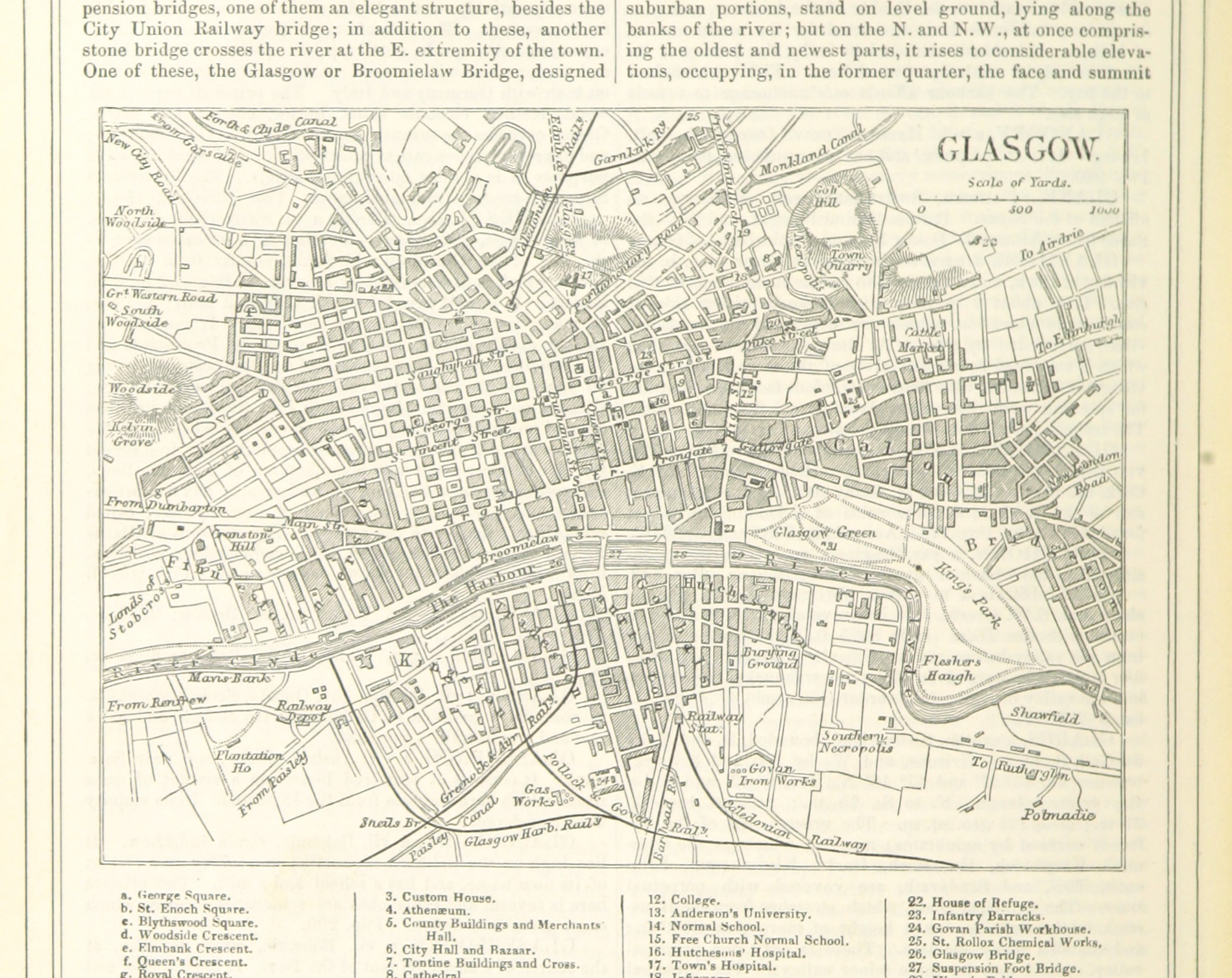
Town plan of Glasgow, from Blackie's Imperial Gazetteer
Detailed street plan showing the River Clyde, bridges, Glasgow Green and packed street blocks with named public buildings.
1805 · The British Library · Wikimedia Commons
No restrictions (plate dated 1805)
In this city
Landmarks of Glasgow, see each in its prime



Ships tied to Glasgow
- HMS Hood: Built on the Clyde; her builder's model is in Glasgow's Riverside Museum
- HMS Renown: Keel laid by Fairfield at Govan, Glasgow, on 25 January 1915
Castles of Glasgow


More cities to explore
 ScotlandStirlingExplore it in 1300 · 1540
 ScotlandEdinburghExplore it in 1560 · 1790 · 1880
 ScotlandAberdeenExplore it in 1500 · 1880
 ScotlandInvernessExplore it in 1560 · 1880
Castles of Europe · Landmarks of Europe · create your own reconstruction.