Historic Cities · Scotland
Stirling through the ages
Stirling is a city in central Scotland, 26 miles (42 km) north-east of Glasgow and 37 miles (60 km) north-west of Edinburgh. The city is surrounded by rich farmland and had a royal citadel, the medieval old town with its merchants and tradesmen, the Old Bridge and the port are all linked in to its history.

Stirling in 1300
Medieval Stirling
This is Stirling at the height of its medieval strategic role: the royal castle crowns a volcanic crag above the lowest reliable crossing of the River Forth. The walk follows the river and the burgh's steep spine of houses and narrow wynds up to the rock, looks across to Cambuskenneth Abbey, and crosses the busy stone bridge into the carse and the King's Park.
A volcanic crag with a royal keep dominates the skyline, its stonework pale in low sunlight. Below, a narrow medieval stone bridge spans the busy, slow-moving Forth; thatch and timber lean up the slope in a tightly packed burgh of steep, cobbled streets and dark wynds. Across the loops of the river stands the abbey tower; beyond the south bank the marshy carse spreads flat, reed-streaked and dotted with small quays and boats.
The route: 21 streets, squares and views
Carse Approach → Bannock Burn → Riverside Quay → Wolfcraig → Auld Brig (Old Bridge) → Bridgehead → Lower High Street → Mercat Cross → High Street → Wynds and Closes → …
Step inside, 12 interiors
Fulling Mill Interior · Quay Warehouse · Bridge Toll Booth · Cloth Merchant's Shop · Tolbooth Council Chamber · Butcher's Longhouse · Burgess Hearthroom · Holy Rude Nave · Gatehouse Guardroom · Parker's Lodge · Abbey Choir · Great Hall
Planned from the Wikipedia record: Stirling.
Stirling in 1540
Renaissance Stirling
Stirling in 1540 is a royal centre clinging to its crag: the Stewart court at the palace on Castle Hill, the burgh crowded along the ridge, and the King's hunting park beyond. The walk follows the approach from the Carse across the bridge, up through the market and burgh lanes, around the castle's façades and gardens, and into the royal outskirts and parkland.
A jagged crag topped by the compact sweep of Stirling Castle dominates the townscape; behind its curtain of harled walls the new Royal Palace block rises with ornamented stone, carved heads and vertical chimneys. The burgh runs along a narrow ridge of stone and timber houses with slate and thatch roofs, narrow wynds, and a packed mercat by the bridge. Beyond, the flat green Carse and the tree-scattered King's Park soften the horizon under quick low light and frequent river mist.
The route: 24 streets, squares and views
Carse of Stirling → Stirling Bridge → Bridge Street → The Mercat Cross → High Street → Church of the Holy Rude → Castle Wynd → Castle Hill → Forework Gate → Outer Defences → …
Step inside, 12 interiors
Tolbooth Council Chamber · Mercat Cloth Hall · Nave of Holy Rude · Master Mason's Workshop · Forework Gate Guardroom · Palace Kitchens at Work · Great Hall at Feast · Chapel Royal Interior · Painted Chamber with Stirling Heads · King's Painted Bedchamber · Royal Stables Interior · Western Battlements Armoury
Planned from the Wikipedia record: Stirling Castle.
Its story
The story of Stirling.
Torbrex Tam and the Iron Age Forts on Gillies Hill
Stirling's oldest catalogued artefact is a stone cist found at Coneypark Nursery in 1879. Bones from it were radiocarbon dated to within the range 2152 to 2021 BC; the man they belonged to, nicknamed Torbrex Tam, died while still in his twenties. The earliest known structures in the area, two Neolithic cursus at Bannockburn, have since been destroyed, but cup and ring marks dating to around 3000 BC survive in King's Park, and Gillies Hill to the south carries two Iron Age fortifications: the Gillies Hill fort, about 2,500 years old, and the later Wallstale Dun on the southern end of Touchadam Craig, related in form to brochs and appearing to coincide with the Roman period, one of some forty such structures in the wider area. The Randolphfield standing stones were once thought to be more than 3,000 years old, but recent radiocarbon dating suggests they may date instead from the time of Bruce.
Strivelin and the Lowest Crossing of the Forth
The town grew up around a castle standing on an ancient quartz-dolerite sill at the lowest crossing point of the River Forth, where the river widens and becomes tidal, at the point where the Lowlands meet the Highlands along the Highland Boundary Fault. Control of the bridge brought military advantage in times of unrest and excise duty, or pontage dues, in peacetime; excise men were installed in a covered booth in the centre of the bridge to collect tax from anyone entering the royal burgh with goods. The credo "he who holds Stirling, holds Scotland" is sometimes attributed to Robert the Bruce.
The name appears as Strivelin(g) in early sources, later becoming Stirveling and finally Stirling, and its meaning, even the language it comes from, is a matter of debate. J. B. Johnston's Place-Names of Scotland suggested a Brittonic origin in 1930, and most commentators thereafter thought the name likely Brittonic, but a comprehensive survey of the evidence by Thomas Owen Clancy in 2017 showed a Brittonic etymology to be unlikely and derived the name from Gaelic srib-linn, "pool in the river". Bede's eighth-century Ecclesiastical History of the English People mentions a place called urbs Giudi, a name thought to be Celtic; its location is not certain, but a 2023 study found that Stirling is the identification favoured by most scholars, and supported it. The similar-looking urbs Iudeu, a battle-site named in the ninth-century Historia Brittonum, has often been assumed to be the same place, though that identification is uncertain.
Two stories fastened themselves to the crossing. A ninth-century legend holds that when Stirling was temporarily under Anglo-Saxon sway it was attacked by Danish invaders, and that the sound of a wolf roused a sentry who alerted the garrison and forced a retreat; the wolf was adopted as a symbol of the town, shown on the Stirling Jug of 1511, and the area is still known as Wolfcraig. Boece relates that in 855 Scotland was invaded by two Northumbrian princes, Osbrecht and Ella, who united their forces with the Cumbrian Britons to defeat the Scots, secured the castle and built the first stone bridge over the Forth, reportedly raising on it a crucifix inscribed to mark the marches between Angles, Britons and Scots. A version of the second half of that inscription (Hic Armis Bruti Scoti Stant Hic Cruce Tuti) is one of two Latin mottoes on the earliest burgh seal, of which an impression of 1296 is on record; the other, Continet Hoc in Se Nemus et Castrum Strivelinse, names the wood and the castle of Stirling.
David I's Royal Burgh and the Wars of Independence, 1124–1314
David I created Stirling a royal burgh between 1124 and 1127, and later charters were reaffirmed by subsequent monarchs. The ferry, and later the bridge, brought wealth and strategic influence, as did the tidal port at Riverside. As the economy grew, a royal park was established in the twelfth century as a landscape setting north of the castle, and the short-lived New Park followed in the later thirteenth century, containing the cockshot wood at Coxet Hill that was likely used as a base at the Battle of Bannockburn. The Church of the Holy Rude, founded in 1129, is the second oldest building in the city after the castle.
Major battles of the Wars of Scottish Independence were fought at the Stirling Old Bridge in 1297, involving Andrew Moray and William Wallace, and at the nearby village of Bannockburn in 1314, involving Robert the Bruce. After the Battle of Stirling Bridge, Moray and Wallace wrote to the leaders of the Hanseatic League in Lübeck and Hamburg to encourage trade between Scottish and German ports. There were also several sieges of Stirling Castle during the conflict, notably in 1304.
The Port at Riverside: Bruges, Veere and Danzig
The town's port supported foreign trade, historically doing significant business in the Low Countries, particularly with Bruges and with Veere. By the sixteenth century there were so many Scots in Danzig, in Prussia, that they had their own church congregation, and trade with that city is mentioned in Stirling Council's minutes of 1560. An account from around John Cowane's time states that about 30,000 Scots families were living in Poland, although that figure was possibly an exaggeration. There was Baltic trade of other kinds too, including a timber trade with Norway.
Fire, Coronation and the Burgh Wall, 1405–1648
Stirling suffered a catastrophic fire in 1405, after which the Church of the Holy Rude was rebuilt in the fifteenth century. At Cambuskenneth Abbey, now ruined, lie James III of Scotland and his queen, Margaret of Denmark; the king died at the Battle of Sauchieburn, at the hands of forces nominally led by his son and successor James IV. The death of James V led to the Rough Wooing, the period in which Henry VIII of England attempted to marry the infant Mary, Queen of Scots to his son. Stirling responded by constructing a burgh wall to the south of the town, which is among the best preserved in Scotland; recent archaeological research has identified two further bastions or positions of strength on it, along with the town's last surviving medieval gate.
On 29 July 1567 the infant son of Mary, Queen of Scots was anointed King of Scots as James VI in the Church of the Holy Rude by Adam Bothwell, the Bishop of Orkney, the service concluding after a sermon by John Knox; the church is reputed to be the only surviving church in the United Kingdom apart from Westminster Abbey to have held a coronation. James was educated by George Buchanan and grew up in Stirling, and was later crowned King of England and Ireland on 25 July 1603. During the Wars of the Three Kingdoms the Battle of Stirling was fought in the centre of the town on 12 September 1648; musket shot marks that may come from Cromwell's troops are clearly visible on the tower and apse of the Holy Rude, and on a gravestone in the cemetery.
Jacobites, Drovers and the End of the River Trade, 1715–1885
The fortifications kept a strategic military role through the eighteenth-century Jacobite risings. In 1715 the Earl of Mar failed to take control of the castle. In January 1746 the army of Bonnie Prince Charlie seized control of the town but again failed to take the castle, and on its consequent retreat northwards blew up the church of St Ninians, where it had been storing munitions; only the tower survived, and can be seen to this day.
After the Jacobite threat had faded but before the railways were established, Highland cattle drovers used the Auld Brig on their way to market at Falkirk or Stenhousemuir. Three times a year, tens of thousands of cattle, sheep and ponies were moved together to the trysts in the south, some drovers going as far as Carlisle or London's Smithfield; a dispute with a tollman at St Ninians is recorded as having produced a four-mile tailback of livestock reaching to Bridge of Allan. In the early nineteenth century an "exceedingly low" cost steamboat service ran between Stirling and Newhaven or Granton. The coming of the railways in 1848 started the decline of the river traffic, and the Alloa Swing Bridge, built downstream between Throsk and Alloa in 1885, both restricted access for shipping and ended Stirling's long standing as the Forth's lowest reliable crossing point, that is, the lowest crossing needing neither a weather-dependent ferry nor a seasonal ford.
Prams for Canada, a University and City Status, 1861–2025
The railways took trade away and made some too: one Riverside company sold its reaping machines as far afield as Syria and Australia, and a company making baby carriages, set up in 1861, exported prams to Canada, South America, India and South Africa. The Princes Street drill hall was completed in 1908, and the Municipal Buildings, which formed the headquarters of Stirling Burgh Council for much of the twentieth century, in 1918; Stirling was a large burgh from 1930 until 1975. Use of the port increased somewhat after the world wars, including a tea trade with India, but with normal shipping lanes open again and the railways grown, the Forth Rail Bridge among them, the harbour was left uneconomical, and by the middle of the century it had ceased to operate. Construction of the A9 bypass under the railway station in the 1960s cut the river off from the city centre.
The University of Stirling opened in 1967 on a greenfield site outside the town and grew into a major research centre; its Innovation Park, begun in 1993, is home to forty companies engaged in research and development, and in 2025 the university had 18,500 students globally, more than 30 per cent of them international. The financial services and insurance company Scottish Amicable Life Assurance established a large base at Craigforth on the outskirts in the 1970s. The Forthside regeneration project, on the site of the former port area and a 40-acre former Ministry of Defence site beside the railway station, has reconnected the city centre to the Forth.
Stirling was granted city status in 2002 as part of the Golden Jubilee celebrations, and the university and Stirling Council are now two of the biggest employers in the area. Walking the Marches (a custom probably started in the twelfth century, when the only way the town's boundaries could be protected was to walk round inspecting them annually, done by the Birlaw men drawn from the Seven Trades, the Guildry and the Council) was revived in 2014 after an official abeyance of several years, and is now held on the last Saturday in May. In the run-up to 2024 the city marked its 900th anniversary, dated to the earliest point at which its founding could have happened, the coronation of David I. The 2022 census recorded 38,587 people in the city and 92,600 in the wider Stirling council area, for which Stirling is the administrative centre.
From the archive
Stirling on paper: the old town as it was mapped.
A period plan or bird's-eye view of the old town, drawn between 1500 and 1850, the streets this page's reconstructions walk. Public domain, with its source named.
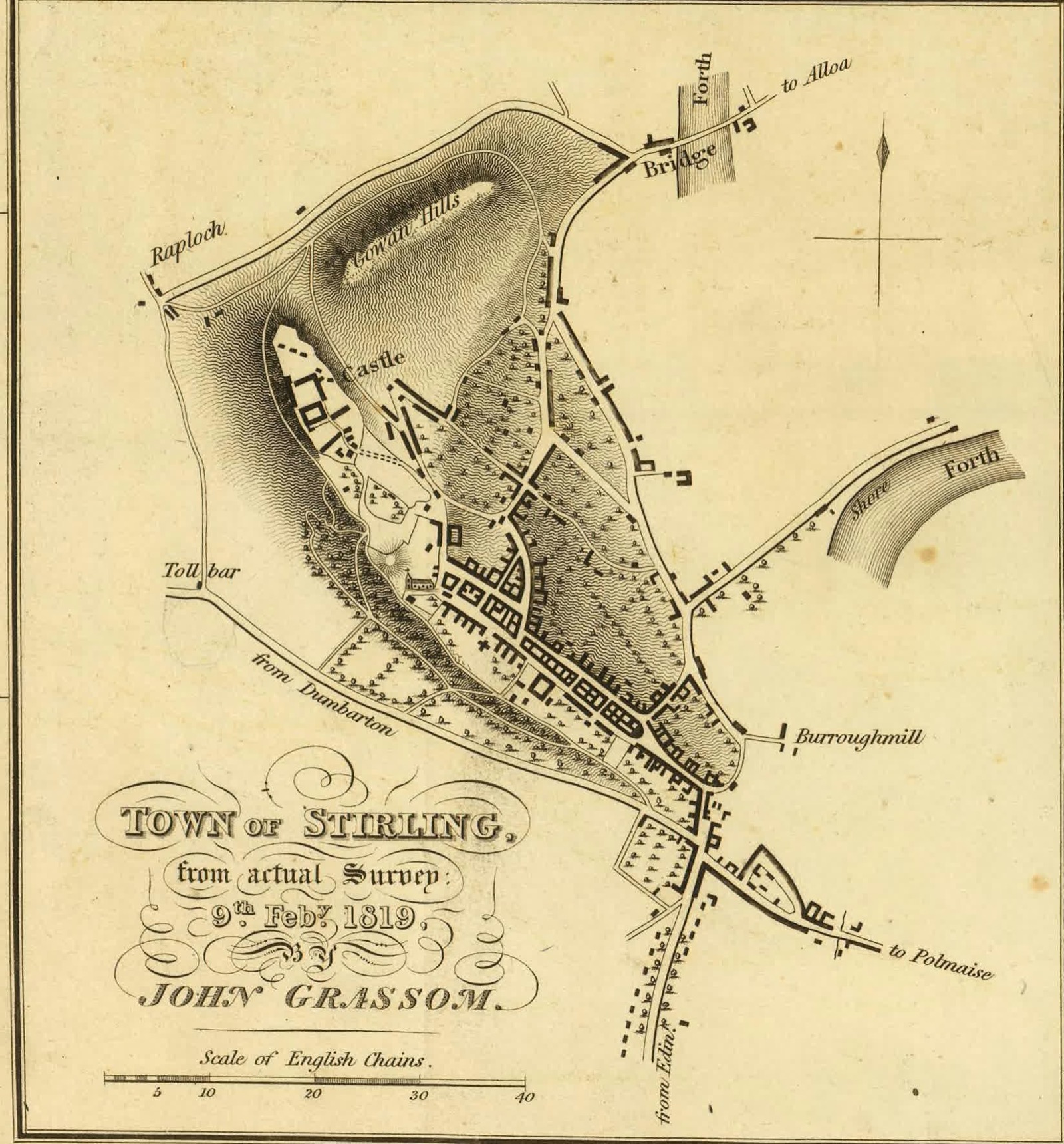
Town of Stirling, from actual survey, 9th February 1819, by John Grassom
Grassom's surveyed town plan shows Stirling Castle on its rock, the walled old town's street blocks, the Toll bar, and the bridge over the Forth on the Alloa road.
1819 · John Grassom (surveyor) · John Thomson & Co., Edinburgh · Wikimedia Commons
Public domain (plate dated 1819)
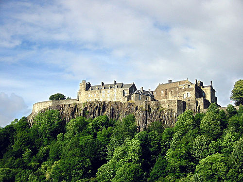
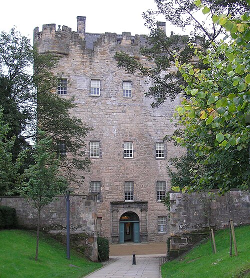
Castles of Stirling




More cities to explore
 ScotlandGlasgowExplore it in 1650 · 1775 · 1888
 ScotlandEdinburghExplore it in 1560 · 1790 · 1880
 ScotlandAberdeenExplore it in 1500 · 1880
 ScotlandInvernessExplore it in 1560 · 1880
Castles of Europe · Landmarks of Europe · create your own reconstruction.