Historic Cities · France
Carcassonne through the ages
Carcassonne is a French fortified city in the department of Aude, region of Occitania. It is the prefecture of the department.

Carcassonne in 1300
The Fortified Cité
In 1300 Carcassonne is a royal frontier fortress above the Aude, its two concentric rings of stone and more than fifty towers holding the road to Aragon. The walk passes the Pont Vieux to the bastide, mounts the Porte Narbonnaise and the barbican, circles the lices between the walls, and meets the Chateau Comtal, the basilica of Saint‑Nazaire, garrison men and cloth workers within the walls.
From the plain the Cité rises as a compact mass of golden limestone: a three‑kilometre double enceinte pierced by dozens of round and square towers, narrow roofs of red clay tiles, and the squat silhouette of the Chateau Comtal behind its wet moat. The Aude slips past a low riverside quay and an old bridge; inside the walls lanes tighten, workshops gape onto streets and patrols move along the ramparts.
The route: 21 streets, squares and views
Aude Plain → Pont Vieux → Rue Droite (Bastide) → Market of the Bastide → Porte d'Aude → Porte Narbonnaise → The Barbacane → Outer Ramparts → Les Lices → Gallo‑Roman Wall → …
Step inside, 14 interiors
Bridge Chapel Interior · Clothiers' Hall · Gatehouse Guard Chamber · Stewards' Tournament Lodge · Tower Guardroom · Castle Gatehouse Chamber · Comtal Great Hall · Viscounts' Private Chapel · High Nave with Rose Window · Sacristy of the Canons · Covered Market Hall · Master Weaver's Workshop · Dyer's Workroom · Soldiers' Barracks Hall
Planned from the Wikipedia record: Cité de Carcassonne.
Carcassonne in 1890
Viollet-le-Duc's Carcassonne
The medieval Cité stands in the middle of an ambitious 19th‑century restoration, its double walls and dozens of towers ringed with scaffolding as masons renew stone and raise new slate cones. The walk moves from the Aude plain and the Pont Vieux up into the ramparts and narrow streets where restorers, pilgrims, vignerons and the first railway visitors mingle beneath banners and tarpaulins.
A compact silhouette of crenellated curtain walls, concentric ramparts and more than fifty towers rises from the limestone hill, interrupted by scaffolding and the newly fitted dark slate cones that catch northern light. Below, the red and ochre roofs of the Bastide Saint‑Louis and the slow ribbon of the Aude and its stone Pont Vieux mark a low agricultural plain of vineyards; narrow medieval lanes lead between pale stone houses, workshops and open market squares where 19th‑century dress mixes with traditional regional costume.
The route: 22 streets, squares and views
Plaine de l'Aude → Gare de Carcassonne → Pont Vieux → Bastide Saint‑Louis → Place Carnot → Quai of the Bastide → Porte Narbonnaise → Barbacane of Narbonne Gate → North Ramparts → Flanking Tower → …
Step inside, 13 interiors
Railway Waiting Room · Old Bridge Toll Room · Vigneron's Kitchen · Café of the Square · Wine Merchant's Cellar · Narbonnaise Gate Guardroom · Flanking Tower Chamber · Viscounts' Antiquities Room · Viscount's Great Hall · Nave beneath Restorers' Trestles · Carpenter's Workshop · Butchers' Vaulted Hall · Masons' Lodge with Plans
Planned from the Wikipedia record: Cité de Carcassonne.
Its story
The story of Carcassonne.
Carsac, the Oppidum of the Volcae Tectosages
Carcassonne sits in the plain of the Aude, in the corridor between the Montagne Noire to the north and the Pyrenean foothills to the south, on the routes linking the Atlantic to the Mediterranean and the Massif Central to the Pyrenees. The first signs of settlement in the region have been dated to about 3500 BC, and the hill site of Carsac (a Celtic place-name kept at other sites in the south) became an important trading place in the sixth century BC, when the Volcae Tectosages fortified it into an oppidum. The familiar story of the name, in which a châtelaine called Lady Carcas ends a siege by a ruse and the bells ring out (“Carcas sona”), is a modern reconstruction of a sixteenth-century depiction, memorialised in the neo-Gothic figure of Mme Carcas on a column near the Narbonne Gate; the name can instead be derived as an augmentative of the name Carcas.
The Romans recognised the position early, fortifying the hilltop around 100 BC and eventually making it the colonia of Julia Carsaco, later Carcaso and then Carcasum, the consonants swapping by metathesis. Under the early Empire the Via Aquitania was laid across the isthmus, running up the Aude from Narbonne on the Mediterranean through Carcassonne and on by way of Toulouse towards the Atlantic. The main part of the lower courses of the northern ramparts is Gallo-Roman work, and one section of the walls still stands out from the medieval fabric by its red brick layers and shallow-pitched terracotta roofs. The Romans held the hilltop until the demise of the Western Empire.
Visigothic Septimania, Clovis and Forty Years of Muslim Rule
The Visigothic king Theodoric II had held Carcassonne since AD 453, and in AD 462 the Romans officially ceded Septimania to him; Theodoric is thought to have begun the predecessor of the basilica now dedicated to Saint Nazarius. In AD 508 the Visigoths successfully foiled attacks by the Frankish king Clovis I. Arab and Berber Muslim forces invaded Septimania in AD 719 and deposed the local Visigothic kingdom the following year. After the Frankish conquest of Narbonne in 759 they were defeated by the Franks and withdrew to Andalusia, ending forty years of occupation, and the Carolingian king Pepin the Short came up reinforced.
From Count Bello to the Trencavel Viscounts
The city and the country around it were then held as a medieval fiefdom, the county of Carcassonne, often united with the county of Razès. The county's origins probably lie with local representatives of the Visigoths, but the first count known by name is Bello, of the time of Charlemagne. Bello founded a dynasty, the Bellonids, who would hold many honores across Septimania and Catalonia for three centuries.
In 1067 Carcassonne passed to Raimond-Bernard Trencavel, viscount of Albi and Nîmes, through his marriage to Ermengard, sister of the last count of Carcassonne. Over the following centuries the Trencavels allied in turn with the counts of Barcelona and with those of Toulouse. They built the Château Comtal and the Basilica of Saints Nazarius and Celsus, and in 1096 Pope Urban II blessed the foundation stones of the new cathedral.
The Albigensian Crusade and the Expulsion of August 1209
Carcassonne was a stronghold of Occitan Cathars, and in August 1209 the crusading army of the papal legate, the abbot Arnaud Amalric, laid siege to it. Viscount Raymond-Roger de Trencavel was imprisoned while negotiating the surrender of his city and died in mysterious circumstances three months later in his dungeon. The people of Carcassonne were allowed to leave, in effect expelled from their city with nothing more than the shirts on their backs. Simon de Montfort was appointed the new viscount and added to the fortifications. One of the towers of the walls housed the Catholic Inquisition in the thirteenth century and is still known as the Inquisition Tower.
Border Fortress of the French Crown, 1240–1355
Trencavel's son tried to reconquer his old domain in 1240 and failed, and in 1247 the city submitted to the rule of the kingdom of France. Under the Treaty of Corbeil of 1258 Carcassonne became a border fortress between France and the Crown of Aragon. King Louis IX founded the new part of the town across the river (the ville basse, settled by the inhabitants expelled after the crusade, a bastide whose regular hexagonal plan of right-angled streets still runs around a central place), and he and his successor Philip III built the outer ramparts of the fortress above it.
Contemporary opinion still considered the fortress impregnable. During the Hundred Years' War, Edward the Black Prince failed to take the city in 1355, though his troops destroyed the lower town. In sieges, temporary wooden platforms and walls were fitted to the upper walls through square holes in the face of the stone, sheltering the defenders and letting them work out beyond the wall to drop projectiles on attackers below.
Wool, the Ottoman Market and the Fortress Abandoned
The Treaty of the Pyrenees transferred the border province of Roussillon to France in 1659, and Carcassonne's military significance was reduced with it. The fortifications were abandoned and the place became chiefly an economic centre of the woollen textile industry: a source of 1723 quoted by Fernand Braudel called it “the manufacturing center of Languedoc”. It remained so until the Ottoman market collapsed at the end of the eighteenth century, after which it reverted to a country town.
The town hall, the Hôtel de Rolland, was completed in 1761, and in 1764 the bastide's own ramparts were pulled down on the order of Bishop Armand Bazin de Bezons; the broad boulevard that rings the lower town follows their line. The Canal du Midi, which runs through the town north of the bastide, carried heavy commercial traffic before river tourism replaced it, and the port of Carcassonne and the lock opposite the station remain in use.
From the Demolition Decree of 1849 to Three Million Visitors a Year
Carcassonne was demilitarised under Napoleon Bonaparte and the Restoration, and the fortified cité fell into such disrepair that the French government decided it should be demolished. The decree to that effect, made official in 1849, caused an uproar. The antiquary and mayor of Carcassonne, Jean-Pierre Cros-Mayrevieille, and the writer Prosper Mérimée, the first inspector of ancient monuments, led a campaign to preserve the fortress as a historical monument, and later that year the architect Eugène Viollet-le-Duc, already at work restoring the Basilica of Saints Nazarius and Celsus, was commissioned to renovate it.
Work began in 1853 on the west and south-west walls, then on the towers of the porte Narbonnaise and the main entrance to the cité. The fortifications were consolidated here and there, but the chief attention went to the roofing of the towers and to the ramparts, where Viollet-le-Duc ordered the destruction of structures that had encroached against the walls, some of them of considerable age. He left copious notes and drawings at his death in 1879, and his pupil Paul Boeswillwald and later the architect Nodet carried the rehabilitation on. The restoration was strongly criticised in his own lifetime: fresh from working in the north of France he roofed the towers in slate, though none was quarried anywhere nearby, and added pointed tips to the roofs; both were claimed to be more typical of northern France.
The cité was added to the UNESCO World Heritage list in 1997 for the exceptional preservation and restoration of the medieval citadel, and Carcassonne now depends heavily on the tourism that brings some three million visitors a year, alongside manufacturing (shoes, rubber and textiles in the lower town), and an AOC winegrowing region. It is the prefecture of the department of Aude, with 46,080 inhabitants in 2023 and 114,259 in the wider Carcassonne Agglo. The language historically spoken here and throughout the region was not French but Occitan, in which the town is Carcassona. The Viguier and La Conte quarters, which hold most of the city's social housing and whose residents are largely immigrants or of immigrant descent, are classed as priority neighbourhoods, with a poverty rate above 60 per cent, among the highest in France.
From the archive
Carcassonne on paper: the old town as it was mapped.
A period plan or bird's-eye view of the old town, drawn between 1500 and 1850, the streets this page's reconstructions walk. Public domain, with its source named.
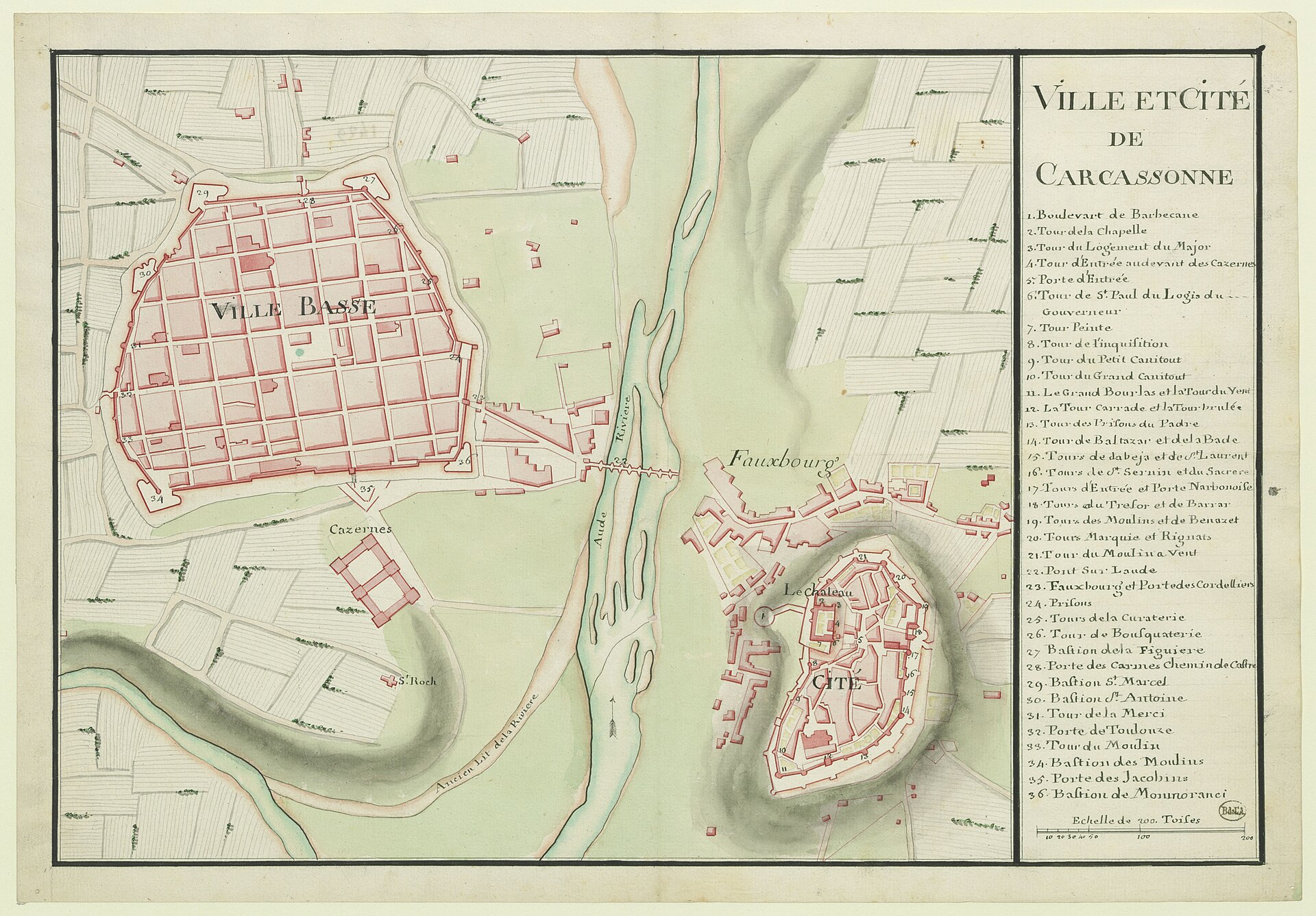
Town plan of Ville et Cité de Carcassonne (Ville et cité de Carcassonne)
Shows the fortified Cité and grid-pattern Ville Basse with enclosing walls, bastions, gates, the Aude river and numbered towers.
1787 · Wikimedia Commons
Public domain (plate dated 1787)

Castles of Carcassonne

More cities to explore
 SpainGironaExplore it in 1350
 SpainBarcelonaExplore it in 1350 · 1888 · 1915
 FranceParisExplore it in 1250 · 1670 · 1789 · 1889
 FranceRouenExplore it in 1431 · 1540 · 1876
Castles of Europe · Landmarks of Europe · create your own reconstruction.