Historic Cities · France
Mont-Saint-Michel through the ages
Mont-Saint-Michel is a tidal island and mainland commune in Normandy, France.

Mont-Saint-Michel in 1250
The Marvel New-Built
This is Mont-Saint-Michel at the abbey's Gothic height: the three-storeyed Merveille stands barely a generation old above the rock and the island draws pilgrims from across the flats. The walk follows the low-tide crossing and climbs the single street of inns to the Grand Degré, then onto the abbey platform, cloister and terraces that look out over Tombelaine and the salt meadows.
A compact granite cone rises from tidal sands, its silhouette crowned by the abbey church and the newly completed three-storeyed Merveille; pale Caen-stone capitals and thin pointed vaults puncture grey walls. A single narrow street of timber-fronted inns and shell-sellers snakes up within stout town walls, while outside the mount the bay opens to vast flats, Tombelaine islet and salt-meadow pastures grazed by small flocks.
The route: 9 streets, squares and views
Bay Crossing at Low Tide → Tombelaine Islet → King's Gate (Porte du Roy) → La Grande Rue → Grand Degré Stair → Logis Abbatiaux and Bailliverie → Abbey Church Platform → Cloister of the Merveille → Upper Terrace Overlooking Bay
Step inside, 5 interiors
Almoner's Dormitory · Pilgrim Inn Low Room · Salle des Chevaliers Scriptorium · Hidden-Window Refectory · Double Colonnade
Planned from the Wikipedia record: Mont-Saint-Michel Abbey.
Its story
The story of Mont-Saint-Michel.
Mont Tombe, the Oratory of 708 and the First Village
The rock is a granite outcrop about 960 metres in circumference, rising 92 metres above a sandy plain, left standing when erosion stripped the softer schist around it. The bay has a tidal range of roughly fourteen metres between the highest and lowest water marks, and the flats can be crossed on foot only at low water. Before any monastic establishment stood on it the island was called Mont Tombe. Two oratories are said to have been raised there by hermits in the sixth and seventh centuries, one dedicated to Saint Symphorien and the other to Saint Étienne, on the account given in the Revelatio ecclesiae sancti Michaelis archangeli in Monte Tumba.
An oratory to the archangel Michael followed in 708, with the dedication placed in 709 by the Annales du Mont-Saint-Michel, compiled at the beginning of the twelfth century. Legend has the archangel appearing to Aubert, bishop of Avranches, and instructing him to build a church on the islet. Aubert installed a community of twelve canons to serve the sanctuary and receive pilgrims, and from about 710 clerics were calling the place mont Saint-Michel au péril de la mer. The first lay settlement grew on the east of the rock among people fleeing Viking raids, and would have housed the stonecutters, masons and carpenters needed to build the sanctuary, then those who supplied the religious community. After a raid in 870 the population of the surrounding country took refuge on the rock and a bourg formed there.
Between Brittany and Normandy, 867–1030
Unable to hold his kingdom against Viking assault, the Frankish king conceded the Cotentin and, though the wording was not explicit, the Avranchin with it, to Salomon, king of Brittany, by the treaty of Compiègne in 867. The Mont was not among the lands granted to the Viking leader Rollo in 911, and remained under Breton political control while its religious authority continued to run through the diocese of Avranches in the ecclesiastical province of Rouen. In 933 William Longsword obtained the Cotentin and the Avranchin from the king of France, at the expense of a weakened Brittany, and that is the date at which the Mont became officially Norman. He made substantial gifts of land to the canons, nearly all of them lying between the Couesnon and the Sélune. Around 989 to 990 the bishoprics left vacant through the years of raiding received bishops again.
Richard I of Normandy ordered the canons either to give up their loose manner of living or to go; all left except one, Durand. Benedictines were installed in their place in 966, drawn from houses that probably included Saint-Taurin d'Évreux and Saint-Wandrille, under the first abbot, Maynard I, who is credited with the pre-Romanesque church of Notre-Dame-sous-Terre. Fire destroyed the village and the abbey in 992. The dukes of Brittany of the house of Rennes were buried in the abbey's chapel of Saint-Martin, among them Conan I, who took the title Princeps Britannorum when he confirmed a gift to the abbey on 28 July 990 in the presence of all the bishops of Brittany, and Geoffrey I, who gave the abbey the revenues of Saint-Méloir-des-Ondes and Saint-Benoît-des-Ondes. In 1009 the duke of Normandy asserted direct control over the abbey: Maynard II was pushed out to Redon and replaced by Hildebert I. Around 1027 to 1030 Richard II moved the frontier with Brittany from the Sélune to the Couesnon, the river that runs past the Mont.
The Abbey the Norman Dukes Paid For, and the Fire of 1204
Richard II chose William of Volpiano, the Italian architect who had built Fécamp Abbey, as his building contractor. William designed the Romanesque church and placed the crossing of its transept at the very top of the mount, which required a mass of underground crypts and chapels to carry the weight. In the twelfth century Robert de Thorigny, a supporter of Henry II of England, who was also duke of Normandy, reinforced the structures and built the main façade of the church. Norman ducal patronage paid for the abbey's building work over these centuries.
In 1067 the monastery backed William the Conqueror's claim to the English throne, and was rewarded with properties and grounds on the English side of the Channel, including a small island off the south-west coast of Cornwall which was modelled on the Mont and became the Norman priory of St Michael's Mount. The Bayeux Tapestry, made to commemorate the conquest, shows Harold Godwinson pulling two Norman knights out of the quicksand on the tidal flats during the Breton-Norman war.
In 1204 Guy of Thouars, regent for the duchess of Brittany and a vassal of the king of France, laid siege to the Mont. He set fire to the village and massacred its inhabitants, then fell back under the walls of the abbey. The fire he had started spread to the abbey buildings and the roofs burned. Philip Augustus, appalled by the conduct of his Breton ally, granted Abbot Jordan money to rebuild in the new Gothic style.
Pierre le Roy's Fortifications and Two Failed English Sieges, 1386–1469
Pierre le Roy, the twenty-ninth abbot, ruled from 1386 to 1410 and put up new fortifications: a crowning element on the Corbins tower at the north-east corner of the Merveille and a curtain-wall terrace at its base, two turrets added in 1393 to flank the gate of 1257, a fortified residence for himself, and the square-based Pénine tower to guard the Grand Degré. Charles VI is credited with adding towers, successive courtyards and strengthened ramparts to the abbey-mount.
English forces besieged the French-held Mont twice during the Hundred Years' War and failed both times. The first siege began in 1423 and was lifted the following year. In 1433 an English force under Thomas Scales, 7th Baron Scales, came again with wrought-iron bombards; that siege too was lifted the next year, and on 17 June 1434 Scales's men abandoned two of the bombards, which the French recovered and which are still on display. The island was never taken during the war, defended as much by the incoming tide, which stranded, drove off or drowned attackers on foot, as by its walls. When Louis XI founded the Order of Saint Michael in 1469 he intended the abbey church to serve as the order's chapel, but the distance from Paris made that impracticable.
The Prison Years and Their Undoing
Medieval pilgrims, known as Miquelots, walked to the Mont from Italy, Germany and England as well as from other parts of France, and the abbey's wealth extended to daughter houses including St Michael's Mount in Cornwall. Its standing as a place of pilgrimage declined with the Reformation, and by the French Revolution there were barely any monks left in residence. Louis XI had already recognised what the tides did for the site and turned it into a prison, and the abbey served as one regularly under the Ancien Régime. After the Revolution it was closed and converted into a prison outright, at first for clerics who opposed the republican regime, then for high-profile political prisoners.
By 1836 a campaign to restore what was by then regarded as a national architectural treasure had been taken up by influential figures including Victor Hugo. The prison closed in 1863. In 1872 Édouard Corroyer, an architect of historic monuments and a member of the Academy of Fine Arts, was given the job of assessing the condition of the Mont; it took him about two years to persuade his minister to classify it as a historic monument, and he then gave fifteen years to the restoration of la Merveille. More than sixty buildings within the commune are protected as historic monuments.
Occupied 1940, Liberated 1 August 1944
German soldiers occupied the Mont during the occupation of France and used the church of Saint-Aubert as a lookout post. The island was also a considerable draw for German tourists and soldiers: around 325,000 German tourists came between 18 July 1940 and the end of the occupation. After the Allied landings in Normandy began on 6 June 1944, exhausted German troops fell back on strongpoints such as the Mont.
On 1 August 1944 a single American soldier, Private Freeman Brougher of Pennsylvania, from the 72nd Publicity Service Battalion, a small Anglo-American psychological warfare unit, reached the Mont and liberated it, accompanied by two British reporters, Gault MacGowan of the New York Sun and Paul Holt of the London Daily Express. Local people came out to greet the three men, and at the mayor's invitation Brougher signed the Golden Book, the island's record of visiting nobility. The abbey was then used as a prison for the first time since the Revolution, to hold male collaborators.
Silt, the Dam and the Bridge: the Island Today
The link to the mainland has been altered repeatedly. The tidal causeway, uncovered only at low water, was replaced by a raised causeway in 1879, which stopped the tide from scouring silt away from the rock. The coastal flats were turned into polder pasture, shortening the distance from shore to island, and the Couesnon was canalised, concentrating its flow. All of this encouraged the bay to silt up. In June 2006 the prime minister, Dominique de Villepin, and the regional authorities announced a 200 million euro scheme to build a hydraulic dam using the Couesnon and the tides to flush the accumulated silt away and make the Mont an island again. Construction began in 2009, the causeway and its car park were removed, and from April 2012 parking has been 2.5 kilometres away on the mainland. A light bridge by the architect Dietmar Feichtinger, allowing water to move freely around the rock, was opened in July 2014 by President François Hollande, and was submerged completely on 21 March 2015 by a supertide of a kind that occurs about once in eighteen years. When President Emmanuel Macron visited in June 2023 to mark a thousand years of the abbey, he said the dam and the bridge had reduced the silting.
The Mont and its bay were inscribed on the UNESCO World Heritage list in 1979. The islet forms the commune of Le Mont-Saint-Michel, in the arrondissement of Avranches in the Manche; 23 people lived there in 2023. Benedictine monks returned to the Mont in 1966 and were replaced in June 2001 by a community of the Monastic Fraternities of Jerusalem, seven sisters and four brothers, sent from Paris after an appeal by Jacques Fihey, bishop of Coutances and Avranches; they are tenants of the centre for national monuments and play no part in running the abbey. Tourism is effectively the commune's only income, worth 63 million US dollars in 2014, with about fifty shops serving three million visitors a year; the businesses and the village administration have long been held by a handful of families.
From the archive
Mont-Saint-Michel on paper: the old town as it was mapped.
A period plan or bird's-eye view of the old town, drawn between 1500 and 1850, the streets this page's reconstructions walk. Public domain, with its source named.
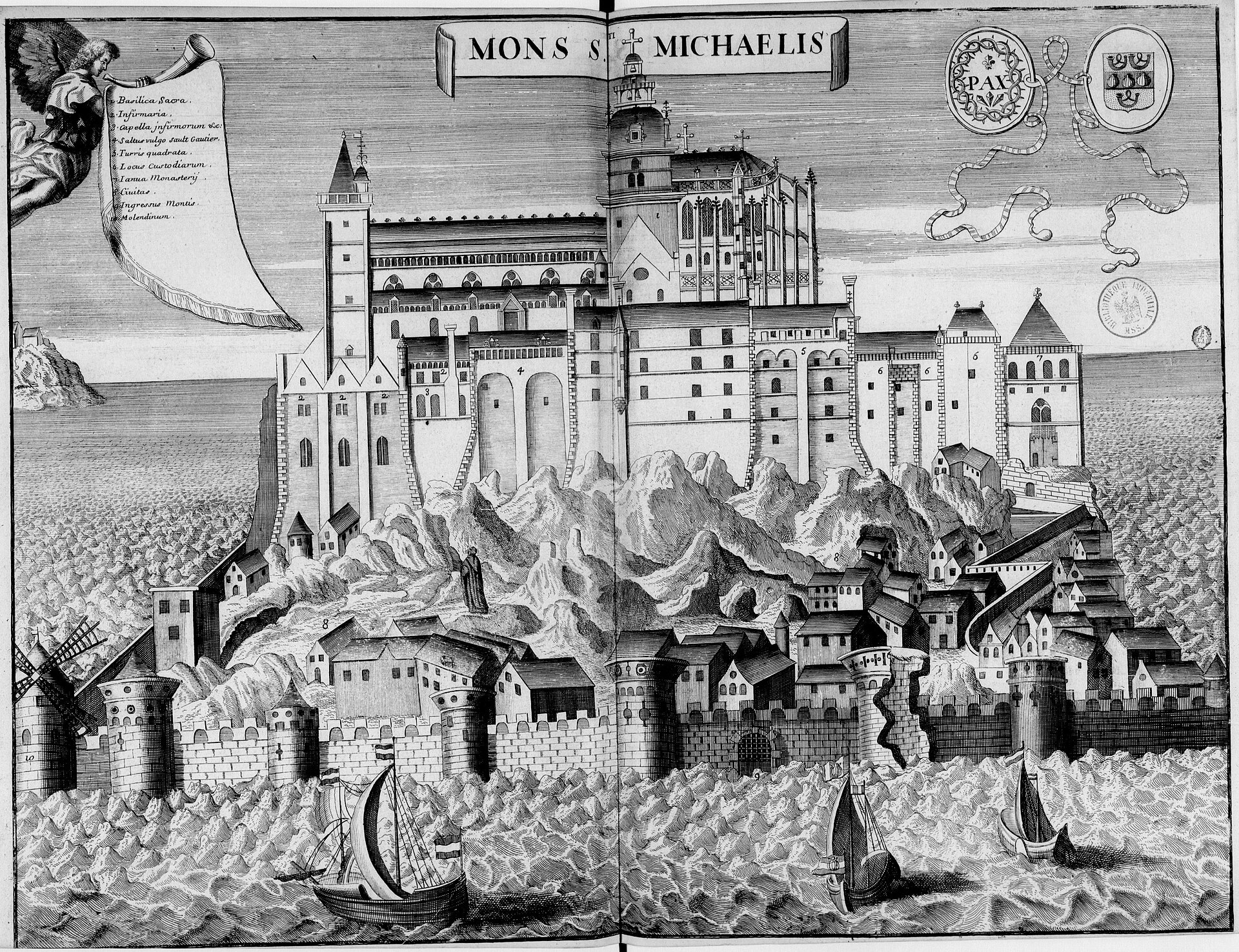
Abbaye du Mont‑Saint‑Michel, from Monasticon Gallicanum
Shows the abbey atop the rocky mount with curtain walls and round towers, the clustered village houses within ramparts, the abbey church and surrounding tidal sea.
1650 · Michel Germain / Achille Peigné-Delacourt · Wikimedia Commons
Public domain (plate dated 1650)

More cities to explore
 FranceSaint-MaloExplore it in 1720
 FranceRouenExplore it in 1431 · 1540 · 1876
 FranceParisExplore it in 1250 · 1670 · 1789 · 1889
 FranceLyonExplore it in AD 100 · 1500 · 1835
Castles of Europe · Landmarks of Europe · create your own reconstruction.