Historic Cities · France
Saint-Malo through the ages
Saint-Malo is a historic French port commune in Ille-et-Vilaine, Brittany.

Saint-Malo in 1720
City of the Corsairs
Saint-Malo in 1720 sits at the height of its corsair riches: shipowners’ granite mansions crowd the ramparts and the quays roar with prize money and barrels of Newfoundland cod. This walk follows the city from the bay and tide-islands, along Garangeau’s walls and bustling quays, through the cathedral’s pinched lanes and market yards to the open sea beyond the Sillon.
A compact, granite-walled island town ringed by thick ramparts and cannon, its skyline a needle-like cathedral spire and the squat keep of the château. Roofs are steep slate and lead, façades grey and patchy, with fresh limewash on some merchant houses. The harbour is a forest of masts and spars; at low tide broad sands and salt meadows unfold between tidal rocks, forts and islets.
The route: 15 streets, squares and views
Baie de Saint-Malo → Fort National → Grand Bé → Le Sillon → Grande Porte → Ramparts Walk → Tour Bidouane → Château Keep → Les Quais → Cod Fleet Basin → …
Step inside, 8 interiors
Gatehouse Guard Chamber · Castle Guardroom · Quayside Tavern · Tarred Chandlery · Shipwright's Timber Workshop · Weighing Hall · Nave of Saint-Vincent · Shipowner's Panelled Salon
Planned from the Wikipedia record: Saint-Malo.
Its story
The story of Saint-Malo.
The Rock, the Fort at Alet and Aaron's Island
Gauls founded a town on the site in the 1st century BC, known under Rome as Reginca or Aletum. By the late fourth century AD the Saint-Servan district held a major promontory fort of the Saxon Shore, guarding the Rance estuary against seaborne raiders from beyond the frontier; the Notitia Dignitatum records its garrison as the militum Martensium under a dux of the Tractus Armoricanus et Nervicanus section of the litus Saxonicum. As the Western Roman Empire declined, Armorica rebelled from Roman rule under the Bagaudae, and the Roman army withdrew, a departure dated to 16 January 423, after which Alet came under repeated attack from the north.
Through the fifth and sixth centuries Armorica received many Celtic Britons fleeing instability across the Channel. Modern Saint-Malo traces its origins to a monastic settlement founded early in the sixth century by Saint Aaron and Saint Brendan, and the sixth-century name Insula Aaronis (Aaron's island) records the hermit who by tradition built his cell on the rock. The town takes its name from Malo, or Maclou, said to have been a follower of Brendan the Navigator and an immigrant from what is now Wales, who settled on the rock in 541. The name is attested in the latinised form Macloviensem in 1162, then as Saent Mallou in 1282 and Saint Malo in 1304; the town is the setting of Marie de France's twelfth-century poem "Laüstic", a love story.
Between Duke and King, 1378–1594
Saint-Malo had a tradition of asserting its autonomy in dealings with the French authorities and even with the local Breton authorities, and for a century its allegiance moved back and forth. In 1378 the Duke of Lancaster landed there and was prevented from getting out again by Du Guesclin. The town was attached provisionally to the French royal domain from 1395 to 1415, recovered by the Duke of Brittany in 1415 when the ducal army returned from Agincourt, and taken into the royal domain again in 1488.
The first Protestants in the town were Calvinists who arrived in the sixteenth century. In 1560 the governor decided to drive them out, judging them dangerous; the community nonetheless grew among the nobility, and dispersed only after the battle of Jarnac in 1569, where two Breton barons who protected the Protestants were killed. After Henri IV came to the throne in 1589 the town's notables feared being drawn into the wars of religion, the more so because their own governor supported the king while the governor of Brittany backed the League. On 11 March 1590, having removed their governor by force, they proclaimed independence from the kingdom of France. The république de Saint-Malo functioned as a de facto city-state for four years and ended on 5 December 1594 with Henri IV's conversion to Catholicism, the town returning to the French kings. From that episode comes its motto, "Ni Français, ni Breton, Malouin suis": not French, not Breton, but Malouin.
Cartier, the Corsairs and the Malouinières
The discovery of the Americas and the growth of trade with the Indies set the town's fortunes rising and multiplied its shipowners. Jacques Cartier (1491–1557) lived in Saint-Malo and sailed from it to the Saint Lawrence, visiting the villages of Stadacona and Hochelaga that would later become the sites of Quebec City and Montreal; as the first European to encounter them, and having learned the local word kanata, meaning a group of houses, he is credited with the discovery of Canada. Guy Le Gentil de la Barbinais, born in the town, is presumed to have been the first Frenchman to sail round the world, between 1714 and 1717, and published his account, Nouveau voyage autour du monde, in 1728. In 1764 the explorer Louis-Antoine de Bougainville named the Falklands the Îles Malouines after the Malouins; Saint-Malo was the point of departure for his ships and colonists, and he founded the archipelago's first settlement. The Spanish Islas Malvinas descends from that name.
The town became notorious as the home of the corsairs, French privateers and sometimes pirates, who forced English ships passing up the Channel to pay tribute and brought back wealth from much further afield. René Duguay-Trouin (1673–1736), born in Saint-Malo, captured Rio de Janeiro in 1711. In 1758 a British expedition landed intending to take the town, made no attempt on it, and instead occupied neighbouring Saint-Servan, where it destroyed thirty privateers before departing. The shipowners' money paid for the country houses known as malouinières, and the same generations produced the mathematician Pierre Louis Moreau de Maupertuis (1698–1759) and the writer François-René de Chateaubriand (1768–1848).
The Slave Ships and the Newfoundland Banks, 1669–1824
The first slave ship fitted out at Saint-Malo sailed in 1669. About 250 slaving expeditions left the port up to 1824, making it the fifth French slaving port behind Nantes, Le Havre, Bordeaux and La Rochelle; an estimated 80,000 enslaved people were carried in ships armed there. Robert Surcouf (1773–1827), corsair, trader and shipowner, was among the last to work the triangular trade, continuing after the traffic was prohibited in 1815.
Running alongside it was the Grande Pêche, the long-range cod fishery on the Newfoundland banks. By the end of the eighteenth century Saint-Malo was a port of the first rank that had taken part in the world's largest traffics for two centuries, but its decline was already pronounced, and the French Revolution accelerated it. The commune was renamed in turn Port-Malo, then Commune-de-la-Victoire, then Mont-Mamet, and a proposal to create a sixth department around Saint-Malo was considered for a time and dropped.
Bathing, the Railway and the British at Saint-Servan
Seaside tourism began with the first bathing establishment in 1838, and the railway reached Saint-Malo in 1864; the town also carried a garrison, the 47th infantry regiment. The Newfoundland fleets kept their place in the calendar: the winter Saint-Ouine fair, which had begun on the islet of the Grand-Bé, moved to the quays below the ramparts, and from 1926 to 1966 coincided with the Pardon des Terre-Neuvas. Electric lighting was installed in 1925, and in 1936 the seawater pool on the Bon-Secours beach was built to designs by the town architect Yves Hémar.
Several English settled in the town from 1802. Anglican worship, refused a place by the prefecture more than once, was held at Saint-Servan from 1822 in the rue Duperré and regularised in 1838; the British community built a new Anglican chapel in the rue du Chapitre in 1875. In 1879 francophone Protestants from Jersey and Guernsey formed a Methodist congregation, which drew immediate disapproval from the Catholic clergy, and opened a chapel at Saint-Servan. Protestants were buried in a reserved plot of the Jeanne-Jugan cemetery, which kept an Anglican square for the English who had come to Saint-Servan for trade. After the Second World War the Anglican community was reduced and the British gathered instead at Dinard; the rue du Chapitre chapel was sold to a developer in 1950 and converted into flats.
Festung Saint-Malo, August and September 1944
During the Second World War the Germans fortified Saint-Malo and its surroundings as one of the Atlantic-coast ports, and Festung Saint-Malo, with the whole coastal zone, became restricted. The beaches at nearby Dinard were heavily fortified against possible Allied commando raids, and artillery at the two places supported one another. More than twelve thousand German troops from different services and units garrisoned the complex, together with stragglers from the fighting in the Cotentin; about eight thousand were in Saint-Malo itself when the battle began. Asked by the town's authorities to surrender, the German commander, Colonel Andreas von Aulock, refused, saying he would defend St Malo to the last man even if the last man had to be himself.
The 83rd Infantry Division attacked on 5 August 1944. German positions at Châteauneuf fell quickly; Cancale was abandoned and occupied on the 6th, and Dinan fell the same day to Free French forces. The Germans shortened their lines and drew back on the old citadel at Alet in Saint-Servan, by then reinforced with concrete, while their artillery on the island of Cézembre lay out of reach of American ground forces. On 13 August the walled town was on fire and a short truce was declared to let French civilians flee. Outlying positions at Saint-Ideuc and La Varde fell to infantry attacks, ending resistance on the north shore of the peninsula, and the citadel surrendered on the afternoon of 17 August.
Cézembre held out longest. Its garrison of Germans, Italians, Russians and Poles, under Oberleutnant Seuss, surrendered on 2 September, when the three hundred men ran out of drinking water, after nearly a month of land, sea and air bombardment that included napalm bombs. The Americans took more than ten thousand prisoners in the fortnight's fighting, von Aulock among them. The shelling, bombing and the fires they started destroyed 80 per cent of the old town: French naval officers still in Saint-Malo had passed on intelligence, but the attackers believed, wrongly, that a large garrison was inside the walls rather than at Alet.
Rebuilt Inside the Walls, Enlarged Outside Them
The ramparts had not been destroyed, and the town was rebuilt within them over a twelve-year period from 1948 to 1960. The approach was historicising rather than exact: new buildings had to adopt the old style, while a limited number of necessary structures were rebuilt identically, using old stones recovered and numbered (the work of Canon Julien Descottes among others), and drawings made before 1944 by the lithographer Daniel Derveaux, which were put at the architects' disposal.
On 26 October 1967 Saint-Malo absorbed the neighbouring communes of Saint-Servan, which had 14,963 inhabitants in 1962, and Paramé, which had 8,811, more than doubling the population of the commune. Saint-Malo is the chef-lieu of its arrondissement and a subprefecture of Ille-et-Vilaine, covering 36.58 square kilometres, with 47,439 inhabitants in 2023 and a summer figure that rises to as much as 300,000. Ferries run from the port to Portsmouth, Poole, Jersey and Guernsey, and the town was the site of an Anglo-French summit in 1998 that led to a significant agreement on European defence policy. It is twinned with Gaspé in Quebec, with Saint-Malo in Quebec and Saint-Malo in Manitoba, and with Port-Louis in Mauritius.
From the archive
Saint-Malo on paper: the old town as it was mapped.
A period plan or bird's-eye view of the old town, drawn between 1500 and 1850, the streets this page's reconstructions walk. Public domain, with its source named.
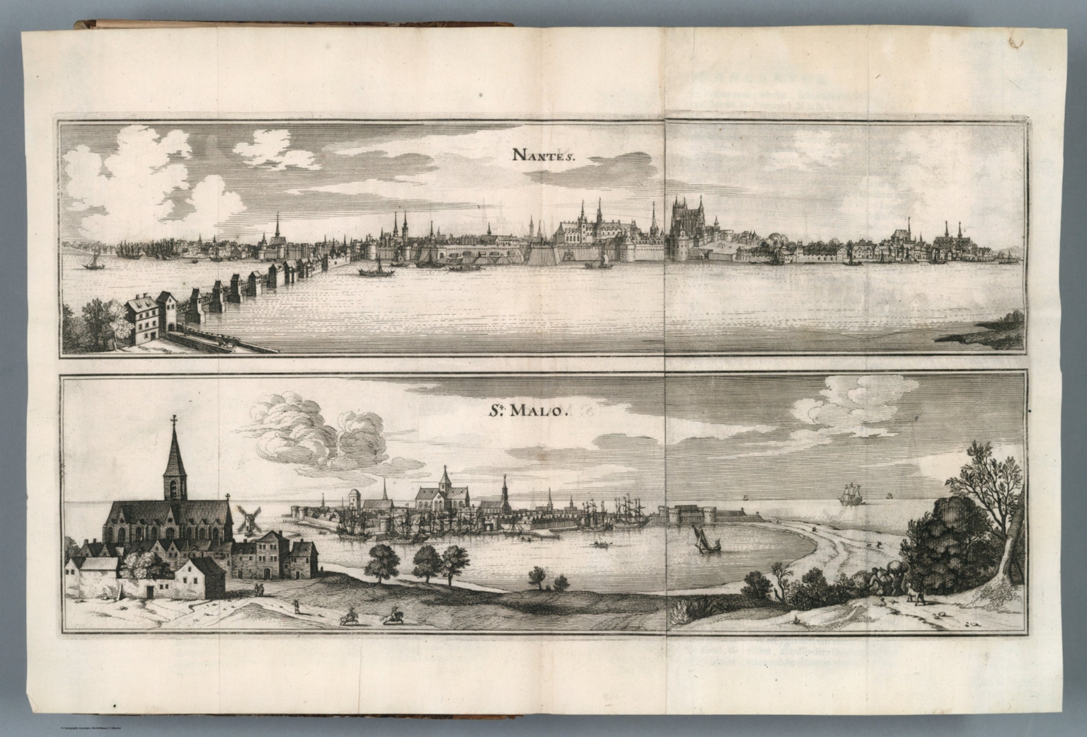
Engraved view of St. Malo, from Merian's Topographia Galliae (1660)
Depicts Saint‑Malo’s walled old town with sea‑facing ramparts and harbour, visible gates, church spires and ships in the roadstead.
1660 · Merian, Kasper, 1593-1650 Zeiller, Martin 1589-1661 · Wikimedia Commons
Public domain (plate dated 1660)
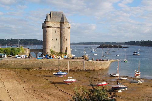
Castles of Saint-Malo

More cities to explore
 FranceMont-Saint-MichelExplore it in 1250
 FranceYsExplore it in AD 920
 FranceParisExplore it in 1250 · 1670 · 1789 · 1889
 FranceRouenExplore it in 1431 · 1540 · 1876
Castles of Europe · Landmarks of Europe · create your own reconstruction.