Historic Cities · Germany
Nuremberg through the ages
Nuremberg is the second-largest city in the German state of Bavaria and the largest city in the cultural region of Franconia. Its 546,397 (2024) inhabitants make it the 13th-largest city in Germany. Situated on the Pegnitz, the city forms a continuous conurbation with the neighbouring cities of Fürth, Erlangen and Schwabach, with the built-up area comprising around 1.4 million inhabitants, while t

Nuremberg in 1350
Imperial Nuremberg
Nuremberg in 1350 is an ascending imperial city clustered beneath the Kaiserburg, where imperial business and long-distance trade meet in narrow, guarded streets. The walk passes the Pegnitz waterfront and the Hauptmarkt (the market square where the Frauenkirche and a grand fountain will soon reshape the skyline), and climbs to the castle terraces for a final sweep over red-tiled roofs and river islands.
From the castle terraces the city is a compact sea of steep, red clay roofs, close timber‑framed houses, and gray stone towers of the ring wall. The Pegnitz threads islands and low stone bridges through the urban fabric; streets are tight, often shadowed, punctuated by open market squares and the vertical mass of parish spires. Materials are oak, wattle-and-daub and quarried sandstone; colors are dark timber, pale limewash and the warm terracotta of tiles under broad daylight or low winter sun.
The route: 21 streets, squares and views
Wöhrder Wiese → Laufer Tor → Laufer Straße → Weißgerbergasse → Fleischbrücke → Pegnitzinsel → Hauptmarkt → Market by Frauenkirche Site → Fountain Site on the Market → Rathaus Forecourt → …
Step inside, 13 interiors
Tanners' Loft · Butchers' Hall · Bronze Foundry · Market Cloth Stall · Apothecary's Shop · Council Hall · Patrician Counting House · Sebaldus Choir · Lorenz Nave · City Mint Workshop · Sinwell Tower Chamber · Imperial Chapel · Kaisersaal
Planned from the Wikipedia record: Nuremberg.
Nuremberg in 1500
Dürer's Nuremberg
Nürnberg in 1500 is a thriving Free Imperial City at the height of its late‑medieval prosperity, where artists, goldsmiths and instrument makers work beside merchants and river trades. The walk follows the Pegnitz and the city ring from the castle gate through markets, workshops and the twin churches to the walls and towers that still define the town.
The skyline is dominated by the Imperial Castle and the twin towers of St. Sebaldus and St. Lorenz, puncturing a sea of steep red-tile roofs and close-packed timber frames. Narrow cobbled streets thread between stone church façades and painted half-timber houses, the Pegnitz threading low and bright through quays and fords. Thick stone walls with round towers encircle the town; forge smoke, drying leather and market colour animate the compact medieval core.
The route: 21 streets, squares and views
Kaiserburg (Castle Hill) → Burgtor (Castle Gate) → Albrecht Dürer's House → Burgstraße → Luginsland Tower → Tiergärtnertor → Weißgerbergasse → Heilig-Geist-Spital → Pegnitz Riverbank → Rathaus and Market Hall → …
Step inside, 13 interiors
Imperial Great Hall · Dürer's Workshop and Studio · Instrument Maker's Workroom · Hall of the Heilig-Geist-Spital · Mill Chamber and Waterwheel · Rathaus Council Chamber · Goldsmith's Workshop and Forge · Goldsmiths' Guild Hall · Master Smith's Forge · Sebaldus Shrine and Chancel · Angelic Salutation Chapel · Organ Loft and Choir Stalls · Behaim's Globe Room
Planned from the Wikipedia record: Albrecht Dürer.
Nuremberg in 1835
Biedermeier Nuremberg
Nuremberg in 1835 is a compact medieval city under the shadow of the Kaiserburg, just beginning to feel the first iron rails of the Bavarian Ludwigsbahn. The walk moves from the western approach and the new railway terminus through the Pegnitz riverside quarters, the market and church squares, and up to the castle ramparts that still dominate a largely unchanged skyline.
The skyline is a serrated outline of church towers and the castle keep above a dense sea of red‑tiled roofs and timber‑framed gables. Narrow cobbled streets follow the Pegnitz, crossed by low stone bridges; the city wall and gate towers remain intact. Stone Gothic church facades, painted timber houses and plastered merchant-burgage create a palette of warm ochres, brown timbers and grey stone under a cool, often clear Franconian light. The first steam engine and modest railway fittings sit awkwardly beside long‑standing crafts and market stalls.
The route: 22 streets, squares and views
Fürth Road Approach → Fürther Tor → Ludwigsbahn Terminus → Kettensteg → Weißgerbergasse → Henkersteg → Fleischbrücke → Hauptmarkt → Frauenkirche Façade → Schöner Brunnen → …
Step inside, 13 interiors
Adler Carriage Shed · Cabinetmaker's Workshop · Toymaker's Workshop · Butchers' Market Hall · Lebkuchen Bakery Oven Room · Frauenkirche Nave · Bratwurstglöcklein Taproom · Dürer Studio Room · Theatre Auditorium · Sebaldus Choir and Nave · Lorenz Chapel and Choir · Castle Great Hall · Sinwell Tower Chamber
Planned from the Wikipedia record: Nuremberg.
Its story
The story of Nuremberg.
The Imperial Castle, the Charter of 1219 and the Diets of the Empire
When Nuremberg was founded is not recorded. The first traces of Slavic settlement near the present main market have been dated to around 850, and the town may have been laid out between about 1000 and 1040 to hold the border country where Saxony, Bavaria, eastern Franconia and Bohemia met, at a junction of important roads. The first documentary mention is a charter of 1050 issued by Emperor Henry III, which shows an imperial castle standing between eastern Franconia and the Margraviate of the Nordgau of Bavaria. The settlement held market rights from the start. In 1065 Henry IV made the imperial estate and its surroundings a jurisdiction of its own, and Conrad III, king of Germany from 1137 to 1152, created the Burgraviate of Nuremberg for the lords of Raabs in Lower Austria; their male line failed around 1189, and the office passed in the 1190s to the last count's son-in-law, Frederick I of the House of Hohenzollern.
The burgraves' authority then drained away. The Hohenstaufen emperors handed most non-military power to a castellan, and from 1173/74 gave the city administration and the municipal courts to an imperial mayor, the Reichsschultheiß, and the strained relations between the two offices ran on for two centuries before breaking into open enmity. In 1219 Frederick II granted the Großer Freiheitsbrief, the Great Charter of Freedom: town rights, imperial immediacy, the privilege of minting coin and an independent customs policy, which removed Nuremberg almost entirely from the burgraves' reach. With Augsburg it became one of the two great trade centres on the route from Italy to northern Europe.
From 1211 to 1543 the city and its castle were among the most frequent meeting places of the Imperial Diet, and Nuremberg became a routine seat of imperial administration; the Golden Bull issued by Charles IV in 1356 required every newly elected king of Germany to hold his first diet there. In 1423 Sigismund of Luxembourg granted that the Imperial Regalia be kept permanently in the city, where they stayed until the advance of French troops in 1796. After fire destroyed the castle in 1420 during a feud between Frederick IV, from 1417 Margrave of Brandenburg, and the duke of Bavaria-Ingolstadt, the city bought the ruins and the castle forest in 1427 and became wholly sovereign within its borders.
Host Desecration, Pogrom and the Plague Years, 1298-1534
In 1298 the Jews of the town were accused of host desecration and 698 of them were killed, in one of the many Rintfleisch massacres; behind the killing lay also the wish to join the northern and southern parts of the town, which the Pegnitz divided. Jews across the German lands were massacred repeatedly during the plague pandemic of the mid-fourteenth century, and in 1349 Nuremberg's Jews suffered a pogrom. They were burned at the stake or expelled, and a marketplace was built over the former Jewish quarter; on it Charles IV's Frauenkirche was raised between 1352 and 1362, where the imperial court worshipped during its stays. Plague itself returned to the city in 1405, 1435, 1437, 1482, 1494, 1520 and 1534.
Rule Without Guilds: Patricians, Presses and Globes
Also in 1349, the craftsmen rose against the patricians in a Handwerkeraufstand, backed by merchants and by some councillors. They failed. Any self-organisation of artisans was banned and the guilds customary elsewhere in Europe were abolished outright; the oligarchs held power for as long as Nuremberg remained a free city, into the early nineteenth century. Trade was run by families such as the Tucher, the Imhoff and the Haller, whose businesses reached across Europe on a slightly smaller scale than those of the Fugger and Welser of Augsburg.
The city became an early centre of humanism, printing, science and mechanical invention. Anton Koberger opened Europe's first print shop here in 1470 and published the Nuremberg Chronicle in 1493, a history of the world written in the local Franconian dialect by Hartmann Schedel and illustrated in part by Albrecht Dürer. Johannes Mueller, later called Regiomontanus, built an astronomical observatory here in 1471. In 1515 Dürer, a native of the city, cut the first printed star charts of the northern and southern skies for Johannes Stabius. The navigator Martin Behaim made the first world globe, and the oldest globe in the world, built in 1492, is among the holdings of the city's museums.
Reformation, Margrave Albert's Attack and the Swedish Occupation of 1632
Nuremberg accepted the Reformation in 1525, and in 1532 the Nuremberg Religious Peace was signed in the city, holding off war between Lutherans and Catholics for fifteen years. During the princes' revolt against Charles V in 1552 the city tried to purchase its neutrality; Margrave Albert Alcibiades, one of the leaders of the revolt, attacked it without a declaration of war and dictated a disadvantageous peace. The Peace of Augsburg confirmed the city's Protestant possessions in 1555 and affirmed its independence from the Bishop of Bamberg.
The trade that had paid for all this was already failing, as routes shifted elsewhere and the city's hierarchy and legal structures ossified. The Thirty Years' War finished the work: repeated quartering of Imperial, Swedish and League troops, the cost of the war and the halt in trade did irreparable damage and nearly halved the population. In 1632 the city, held by the forces of Gustavus Adolphus of Sweden, was besieged by the Imperial general Albrecht von Wallenstein. Nuremberg declined after the war and recovered its importance only in the nineteenth century, as an industrial centre.
Handed to Bavaria, 1806, and the Industrial Century
After the Thirty Years' War the city tried to keep clear of outside affairs, but contributions were demanded of it for the War of the Austrian Succession and the Seven Years' War, and restrictions on imports and exports stripped it of markets for its manufactures. The Bavarian elector Charles Theodore took land the city had won in the War of the Succession of Landshut, and Prussia claimed part of the territory too. Knowing its weakness, the city asked to be incorporated into Prussia; Frederick William II refused, fearing to offend Austria, Russia and France. The imperial diet of 1803 affirmed Nuremberg's independence, but on the signing of the Confederation of the Rhine on 12 July 1806 it was agreed to hand the city to Bavaria from 8 September, Bavaria guaranteeing the amortisation of its public debt of 12.5 million guilder.
Absorbed into a Catholic kingdom, the city had to abandon the exclusion of Catholics from the rights of citizenship. Catholic services had been held there by priests of the Teutonic Order, often in great difficulty; after their possessions were confiscated in 1806 they were given the Frauenkirche on the market in 1809, and the first Catholic parish was established in 1810, numbering 1,010 people by 1818.
Trade revived once the debt had been acknowledged as part of the Bavarian national debt. The first German railway, the Bavarian Ludwigsbahn, ran from Nuremberg to neighbouring Fürth from 1835, and with the railways and Bavaria's entry into the Zollverein came industry: Siemens and MAN built strong bases here and made the city the industrial heart of Bavaria. The population passed 100,000 in 1881, the year the tramway opened; by 1905 the city and its incorporated suburbs held 291,351 people, among them 3,738 Jews.
The Rallies, the Laws and the Deportations, 1927-1945
The Nazi Party chose Nuremberg for its huge conventions because of the city's association with the Holy Roman Empire and its position in the centre of Germany. Rallies were held in 1927, 1929 and annually from 1933 to 1938, on a complex of buildings and assembly grounds designed by Albert Speer and built solely for them, some never finished. Leni Riefenstahl filmed the 1934 rally as Triumph des Willens. At the 1935 rally Hitler ordered the Reichstag to convene at Nuremberg to pass the Nuremberg Laws, which revoked German citizenship for all Jews and other non-Aryans.
The city's Nazi Oberbürgermeister, Willy Liebel, set about stripping late nineteenth-century work from the centre to return it to a medieval appearance he thought fitting for a capital of Nazi pageantry. Among the buildings he marked for demolition was the Grand Synagogue of Nuremberg, whose Moorish revival architecture he considered foreign and irreconcilable with that image; he had it entirely demolished around the time of the party rally in September 1938. Nuremberg was also the base of Julius Streicher, Gauleiter of Franconia, a vicious antisemite and the publisher of Der Stürmer. During the pogrom of 10 November 1938 the two remaining synagogues and numerous Jewish-owned shops were burned to the ground; of the 91 Jews who died in Germany as a result of Kristallnacht, 26, including ten suicides, died in Nuremberg. The Jewish sports club founded in the city in 1913 was dissolved by the Nazi Party in 1939 and re-formed in 1966.
Between 2,000 and 3,000 of the city's Jews fled Germany. By 1941 about 1,800 remained, and over 1,600 of those were rounded up and transported to extermination camps, where they were killed. At the end of the war in 1945 there were no Jews left in Nuremberg; Stolpersteine set in the streets name those persecuted by the regime. The city was headquarters of Wehrkreis XIII and an important site of military production, turning out aircraft, submarines and tank engines; a subcamp of Flossenbürg concentration camp stood here and slave labour was used extensively.
Bombing, Battle and the Trials, 1945-1946
On 2 January 1945 the Royal Air Force and the U.S. Army Air Forces systematically bombed the medieval city centre; about eighty per cent of it was destroyed in a single hour, 1,800 residents were killed and roughly 100,000 displaced. Further attacks followed in February, and about 6,000 residents are estimated to have been killed in air raids altogether. The heavily fortified city was taken between 17 and 20 April 1945 by the U.S. 3rd, 42nd and 45th Infantry Divisions, fighting house to house against determined German resistance.
Between 1945 and 1946 German officials charged with war crimes and crimes against humanity were brought before an international tribunal in the city. The Soviet Union had wanted the trials held in Berlin; Nuremberg was chosen because the rallies had been held there and the laws stripping Jews of their citizenship passed there, which gave symbolic value to making it the place of accountability, and because the Palace of Justice was spacious, largely undamaged and attached to a large prison. Berlin was to be the permanent seat of the International Military Tribunal and further trials were planned, but the Cold War meant they never took place. Many prominent Nazi politicians and military leaders were executed in the city in October 1946. In 1995 the city established the Nuremberg International Human Rights Award, given every two years to those defending human rights.
The city was rebuilt and to some extent returned to its pre-war appearance, much of the work done by the Old Town Friends Nuremberg; a quarter of its buildings date from before the Second World War and the old town is a declared protected area. Nuremberg is now the second-largest city in Bavaria and the largest in Franconia, with 546,397 inhabitants in 2024, a port on the Rhine–Main–Danube Canal and the seat of the Federal Employment Agency and the Federal Office for Migration and Refugees.
From the archive
Nuremberg on paper: the old town as it was mapped.
A period plan or bird's-eye view of the old town, drawn between 1500 and 1850, the streets this page's reconstructions walk. Public domain, with its source named.
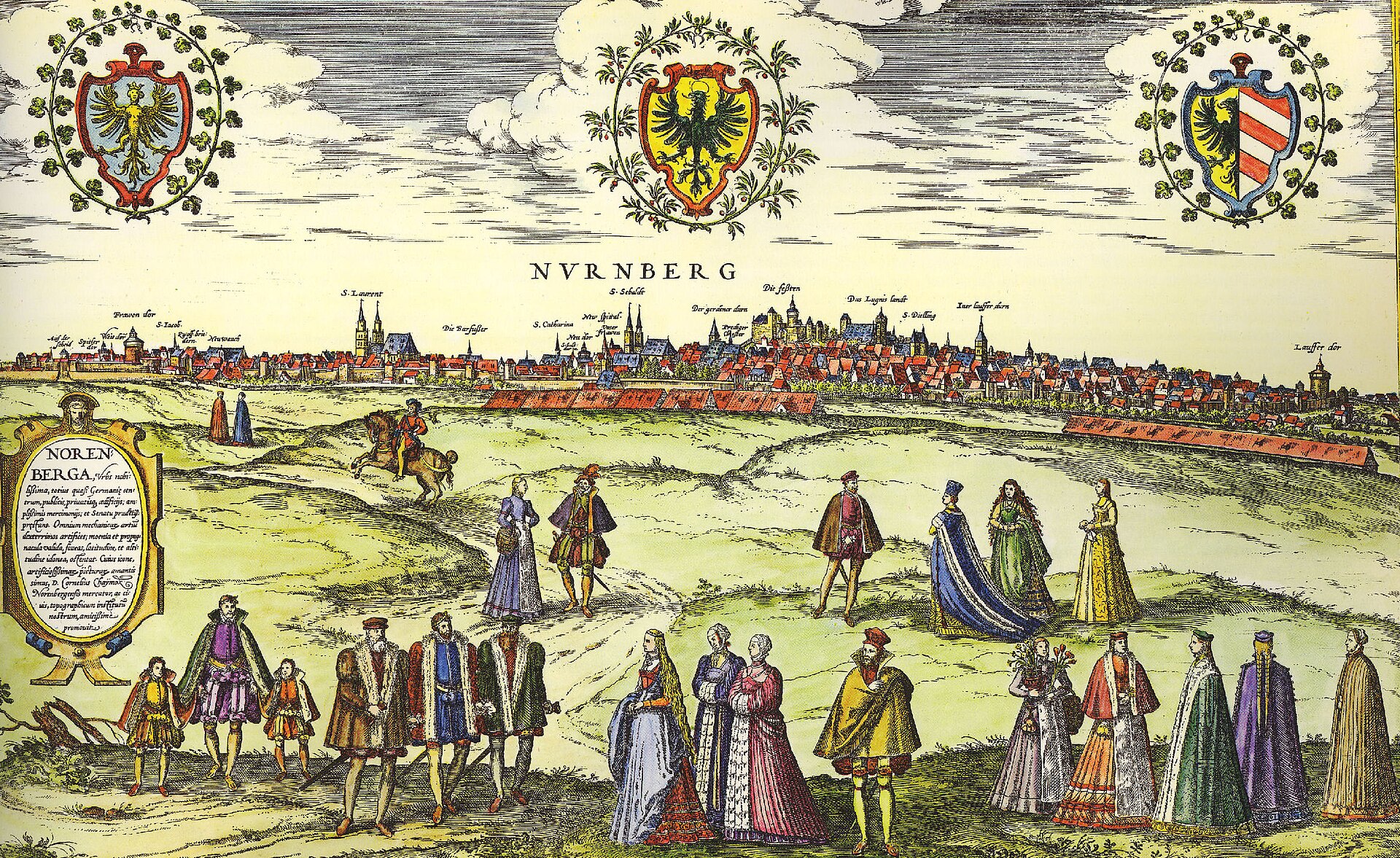
Bird's-eye view of Nuremberg, from Braun & Hogenberg's Civitates Orbis Terrarum
Walled bird's-eye view showing Nuremberg's city walls and gates, the Kaiserburg castle and the twin-spired churches (St. Lorenz, St. Sebald) rising above the roofscape.
1572 · Wikimedia Commons
Public domain (plate dated 1572)


Ships tied to Nuremberg
- German cruiser Nürnberg: Named after the city of Nuremberg
Castles of Nuremberg

More cities to explore
 GermanyRothenburg ob der TauberExplore it in 1520
 GermanyRegensburgExplore it in 1250 · 1750
 GermanyBerlinExplore it in 1750 · 1871 · 1928
 GermanyMunichExplore it in 1500 · 1700 · 1900
Castles of Europe · Landmarks of Europe · create your own reconstruction.