Historic Cities · Portugal
Porto through the ages
Porto, also known in English as Oporto, is the second largest city in Portugal, after Lisbon. It is the capital of the Porto District and one of the Iberian Peninsula's major urban areas. Porto city proper, which is the entire municipality of Porto, is small compared to its metropolitan area, with an estimated population of 273,476 people in a municipal area of 41.42 km2 (16 sq mi).

Porto in 1500
Discoveries-era Porto
Porto in 1500 is a dense, walled river city halfway between medieval fortification and maritime ascendancy, its terraces of granite and red tile stacked above the Douro. The walk moves from the estuary and shipyards through the Ribeira and Miragaia quarters to the cathedral hill, showing sailors, shipwrights and riverside merchants who supply the expeditions of the Age of Discovery.
A compact amphitheatre of steep, narrow lanes and granite houses with red clay roofs climbing from the Douro; the river lined with flat‑bottomed rabelo barges and low wooden shipwright platforms; the cathedral a squat, fortresslike Romanesque mass on the highest ridge; low defensive walls and occasional city gates cutting the silhouette; fishermen and sailors at the water’s edge, merchants and small workshops clustered between squares and quays.
The route: 22 streets, squares and views
Douro River Mouth → Foz do Douro → Gaia Riverside → Gaia Warehouses → Cais da Ribeira → Praça da Ribeira → Ribeira Shipyards → Miragaia Quay → Miragaia Lanes → Fernandina Walls → …
Step inside, 13 interiors
Riverside Wine Cellar · Warehouse Packing Hall · Shipwright Frame Shed · Net-Mending Shed · Gatehouse Guard Chamber · Romanesque Cathedral Nave · Cloister Walk · Episcopal Great Hall · Romanesque Church Nave · Gothic Church Nave · Convent Refectory Hall · Fish Market Hall · Butchers' Stone Hall
Planned from the Wikipedia record: Porto.
Porto in 1790
Port wine Porto
Porto in 1790 is a working river city at the heart of the recently formalised port trade, its fortunes tied to the Douro and to British merchants. The walk follows the riverfront and granite streets from the mouth of the Douro, through Gaia's wine lodges and Porto's rebuilt avenues, to a high viewpoint across the city.
Low, compact roofs of red clay tile and dark timber sit on walls of grey granite; narrow granite streets climb steeply from the Douro. The skyline is dominated by church towers, notably the Clérigos, and by stacked lodges on Gaia's bank. Flat‑bottom rabelo boats with long rudders crowd the quays, their crews guiding oiled oak pipes ashore beneath winter or spring light and frequent Atlantic haze.
The route: 22 streets, squares and views
Foz do Douro → Cais de Vila Nova de Gaia → Gaia's Wine Lodges → Rabelo Boats → Ponte das Barcas → Cais da Ribeira → Praça da Ribeira → Escadas do Codeçal → Rua de São João → Rua das Flores → …
Step inside, 14 interiors
Dim Barrel Hall · Boatmen's Shed · Riverside Warehouse · Merchant Hall · Alehouse Cellar · Counting House · Misericórdia Chapel · Gilded Nave · Romanesque Nave · Brotherhood Nave · Tower Spiral Stair · Factory House Ballroom · Master Cooper's Workshop · Monastery Cloister
Planned from the Wikipedia record: Port wine.
Porto in 1900
Iron-age Porto
Porto in 1900 is an industrializing river city shaped by ironwork, river trade and steep medieval streets. This walk follows the Douro from the Atlantic approach, across the great iron spans of Maria Pia and D. Luís, through quays, markets and tram-lined avenues to the wine lodges of Vila Nova de Gaia and a wide riverside panorama.
The skyline is a tight tumble of red-tiled roofs and church towers pierced by the slender spire of Clérigos and the fortress bulk of the Sé, cut through by two monumental iron bridges in the Eiffel tradition. Streets are narrow and steep, paved in granite; façades show early azulejo tiles and painted plaster; the Douro runs dark and tidal, fringed with stone quays, rabelo boats and lines of port-cellars on Gaia’s slopes. Trams, horse-drawn carts and workmen animate the scenes.
The route: 22 streets, squares and views
Foz do Douro → Passeio Alegre Gardens → Ponte Maria Pia → Campanhã Approaches → Ponte D. Luís I → Cais da Ribeira → Praça da Ribeira → Torre dos Clérigos → Rua das Flores → Praça da Liberdade → …
Step inside, 13 interiors
Goods Shed · Riverside Tavern · Carved Oak Staircase · Grand Banking Hall · Upper Market Galleries · Main Waiting Hall · Arab Room · Gilded Nave · Shipwright's Workshop · Cathedral Nave · Barrel Vault · Tasting Room · Glass Exhibition Hall
Planned from the Wikipedia record: Porto.
Its story
The story of Porto.
Portus Cale, the Port that Named a Country
Before the Roman conquest the region was held by the Gallaeci, a Celtic people, and archaeological remains from that period have been uncovered in several places around the city. Findings suggest human settlement at the mouth of the Douro as early as the 8th century BC, possibly a Phoenician trading post. Under the Roman Empire the place, then Portus Cale, grew into a commercial hub handling trade between Olissipona and Bracara Augusta (Lisbon and Braga), and through the Suebian and Visigothic centuries it became a centre for the spread of Christianity. Its combined Celtic-Latin name has been referred to as the origin of the name Portugal.
Between 714 and 716 Porto came under Muslim control in the Umayyad conquest of Hispania, one of the northern towns taken as the invading forces pushed up the Iberian Peninsula. Christian forces under Alfonso I of Asturias retook it in 741, making it a fortified frontier town. In 868 Vímara Peres, a Galician nobleman and vassal of Alfonso III of León, was granted the fief of Portucale and repopulated and fortified the country between the Minho and the Douro, founding the County of Portucale, later the County of Portugal. In 999 a fleet remembered as the Armada dos Gascões came in through the Douro mouth under Munio Viegas, with Gascon nobles among them Nónego, bishop of Vendôme in France and later bishop of Porto; they took the city and rebuilt it, raising walls and a fortified citadel on the high ground and a main gate named the Porta de Vandoma after Nónego's own country.
In 1093 Teresa of León, an illegitimate daughter of Alfonso VI of Castile, married Henry of Burgundy, who received the County of Portugal as her dowry; in 1111 she granted the couto of Porto to Bishop Hugo. Under her son Afonso I the region declared independence in the twelfth century and became the nucleus of the Portuguese state.
The Avis Cause and the Ships for Ceuta, 1383–1415
Through the dynastic crisis of 1383–85 the city stayed, for most of it, loyal to the Master of Avis, illegitimate son of Pedro I and half-brother of Fernando I. On the morning of 16 July 1384 a Castilian expeditionary force of about 650 men (500 foot and 150 Castilian and French noblemen), which had entered Portugal through Galicia on its way to join John I of Castile at the siege of Lisbon, was met on the northern bank of the Douro by a Portuguese guard of roughly 180 men posted to watch the illegal crossings. The Castilians were driven off northwards, and the supplies they were carrying to the besieging army were seized by Pedro Rito and Dinis Oliveira, officers of the Portuguese garrison; the provisions and siege weapons never reached Lisbon.
In 1387 Porto hosted the marriage of John I of Portugal and Philippa of Lancaster, cementing the Anglo-Portuguese alliance, the oldest enduring military alliance in the world. By the fifteenth century the city was a shipbuilding and maritime centre of consequence, and in 1415 Prince Henry the Navigator launched the conquest of Ceuta from Porto. The nickname tripeiros, tripe-eaters, is said to come from that period, when the better cuts of meat went with the naval expeditions and the tripe was left to the townspeople; tripas à moda do Porto is still the city's emblematic dish.
Barcos Rabelos, the Methuen Treaty and the Revolt of 1757
The city's economic tie to the upper Douro has been documented since the Middle Ages: sumac, dried fruit, nuts and olive oil went out from the riverside quays to markets in the Old World and the New, and from the thirteenth century the wines of the Douro valley came down to Porto in flat-bottomed barcos rabelos. The Methuen Treaty of 1703 tightened the commercial and military tie with England, and by 1717 English firms had established trading houses in the city and were coming to dominate the port wine trade. Much of the industry's infrastructure grew on the south bank at Vila Nova de Gaia, where the slopes hold the cellars from which the fortified wine was packaged, transported and exported.
The Marquis of Pombal answered the English hold on the trade by creating a state-controlled wine company and demarcating the Douro region, the first protected wine region in Europe. In 1757 the Revolta dos Borrachos, the revolt of the drunkards, followed: the company's buildings were attacked, and the rising was brutally suppressed by the authorities. Between 1732 and 1763 the architect Nicolau Nasoni designed the Clérigos church and its tower, and the nautical school, the Aula de Náutica, was founded in 1762. The eighteenth and nineteenth centuries saw Porto emerge as an industrial centre.
The Ponte das Barcas, 1809, and the Siege of 1832–33
In 1806 the city built a floating pontoon bridge across the Douro, the Ponte das Barcas. During the Peninsular War French forces under Jean-de-Dieu Soult took the city, and on 29 March 1809 thousands of civilians trying to flee across the pontoons brought the bridge down, with an estimated 4,000 deaths, the deadliest bridge disaster in history. Shortly afterwards Arthur Wellesley, later Duke of Wellington, retook Porto in the Second Battle of Porto, crossing the Douro in wine barges.
The Liberal Revolution of 1820 began in Porto, calling for a constitutional monarchy and the return of John VI from Brazil. A liberal constitution was enacted in 1822, but civil war followed when Miguel I seized power in 1828, and the city held out through an eighteen-month siege by absolutist forces in 1832–33. That resistance earned it the title granted by Queen Maria II and still carried on its arms (Invicta, the unvanquished city), and the church of Lapa holds the heart of Pedro IV, who left it to the people of Porto for what they had given the liberal cause.
The Ponte das Barcas was replaced by the Ponte D. Maria II in 1843, then by Gustave Eiffel's Maria Pia Bridge in 1877, and in 1886 by the Dom Luís I Bridge, designed by Eiffel's former partner Théophile Seyrig. The Bolsa do Porto, the city's stock exchange, ran from 1834 to 1910, and the region's wealthy industrialists founded the Associação Industrial Portuense in the middle of the century.
Republican Revolt, 1891, and the Monarchy of the North, 1919
The republican revolt of 31 January 1891, the first of its kind in Portugal, took place in Porto and contributed to the fall of the monarchy in 1910. On 19 January 1919 monarchist forces in the city declared the Monarchy of the North in a brief counter-revolution, and Porto served for a short time as the capital of the restored monarchy before republican forces regained control. On 26 April 1919 the city was decorated with the Military Order of the Tower and Sword.
World Heritage since 1996, and the City Now
The historic core was inscribed on the UNESCO World Heritage list in 1996 as the Historic Centre of Porto, Luiz I Bridge and Monastery of Serra do Pilar, and is also a National Monument of Portugal. In 2001 the city shared the title of European Capital of Culture with Rotterdam, which set off a run of cultural and infrastructural projects.
Porto is the capital of its district and the seat of the Metropolitan Area of Porto, which groups seventeen municipalities; the municipality itself covers 41.42 km² and had 248,769 inhabitants in 2023, while the metropolitan area held around 1.9 million people in 2025. The municipal population fell by almost 100,000 between 1981 and 2014 as residents moved out to the suburbs and satellite towns, and has risen by some 12,000 since 2014. As of 2016 estimates, 93.7% of residents were born in Portugal, with others born in Angola, Brazil, Cape Verde and countries across Europe.
The English tie shows beyond the wine trade: the Oporto British School was established in 1894, and the largest British community in Portugal lives in the city. The Kadoorie Synagogue, built in 1938, is the largest synagogue in the Iberian Peninsula and one of the largest in Europe, and presents the history of Porto's Jewish community. The University of Porto, with roughly 28,000 students, is the second largest in the country, and the port of Leixões carries about a quarter of Portuguese international trade. Tourism has grown fast: a 2019 study called Porto one of the fastest-growing European tourist destinations, and by that year more than a tenth of the city's economic activity came from it.
From the archive
Porto on paper: the old town as it was mapped.
A period plan or bird's-eye view of the old town, drawn between 1500 and 1850, the streets this page's reconstructions walk. Public domain, with its source named.
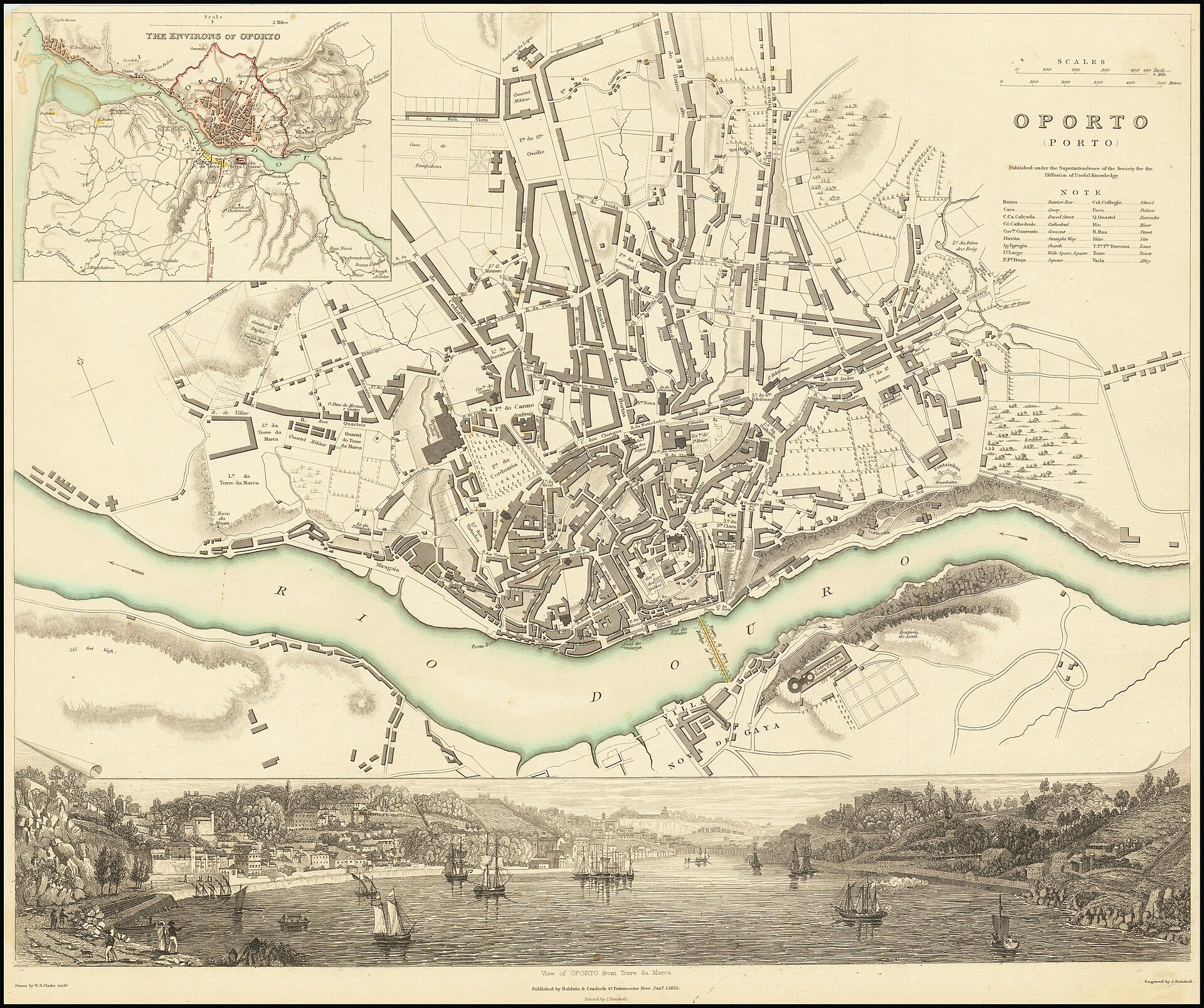
Oporto (Porto): town plan with riverside prospect, William Barnard Clarke, 1833
Detailed street plan of Porto's old town showing dense blocks, the Douro riverfront, quays, and the bridge to Vila Nova de Gaia.
1833 · William Barnard Clarke · Wikimedia Commons
Public domain (plate dated 1833)


More cities to explore
 PortugalCoimbraExplore it in 1750
 SpainSantiago de CompostelaExplore it in 1200 · 1750
 PortugalLisbonExplore it in 1550 · 1750 · 1890
 PortugalSintraExplore it in 1854
Castles of Europe · Landmarks of Europe · create your own reconstruction.