Historic Cities · Finland
Turku through the ages
Turku is a city in Finland and the regional capital of Southwest Finland. It is located on the southwestern coast of the country at the mouth of the River Aura. The population of Turku is approximately 210,000, while the metropolitan area has a population of approximately 320,000.

Turku in 1500
Medieval Åbo
Åbo in 1500 is the small but vital episcopal and mercantile town at the mouth of the Aura, with bishop and castle facing one another across the river. This walk follows the river from the seaward approach, along the timber quays and crooked lanes, past the cathedral hill, the Dominican convent and the Great Market, finishing at the castle keep above the archipelago.
The skyline is a compact pairing of a squat grey stone keep at the river mouth and the high mass of the cathedral on its rise; between them a ribbon of dark water shows timber quays and low wooden houses with tarred planks or thatch. Streets are narrow and crooked, punctuated by cabbage yards, friary courts and the occasional stone merchant house; Hanseatic cogs lie at the quays, ropes and barrels staining the quay timbers.
The route: 16 streets, squares and views
Archipelago Approach → Castle Quay → Crown's Quay → Penny Bridge (Pennisilta) → Stortorget and Rådhuset → Fish Quay → Cabbage Yards and Lanes → St Olaf's Dominican Convent → Tuomiokirkko Hill → Bishops' Hill and Tombs → …
Step inside, 9 interiors
Castle Great Hall · Riverside Warehouse · Town Hall Great Chamber · Convent Refectory · Brick-vaulted Nave · Bishops' Crypt and Tombs · Merchant's Stone Cellar · Bathhouse Washing Hall · Keep's Upper Chamber
Planned from the Wikipedia record: History of Turku.
Turku in 1825
Before the Great Fire
Two years before the great fire that would destroy much of the town, Åbo is the largest wooden city in the North and still the Grand Duchy’s principal port and academy town. This walk moves from the river mouth through the harbour quays, market squares and narrow timber streets up to the observatory on Vartiovuori, showing cathedral, Academy and everyday burgher life in 1825.
In 1825 Åbo is a low, wooden town stitched along the River Aura: a tall cathedral spire above a dense field of timber gables, ochre and red-painted riverside storehouses, long low burgher houses with walled apple yards, and narrow lanes paved with stone or packed earth. Roofs are shingle, turf or birch-bark; bridges and quays throng with sailing ships bound for Stockholm, tar-smelling yards and men in tailcoats, caps and coarse working dress.
The route: 16 streets, squares and views
Ruissalo shore → Åbo harbour → Aurajokiranta warehouses → Pennisilta bridge → Great Square → Old Town Hall → Puutori → Uudenmaankatu → Academy House → Cathedral precinct → …
Step inside, 7 interiors
Tar and Salt Warehouse · Bridge Coffee Room · Council Chamber · Merchant's Empire Parlour · Academy Ceremonial Hall · Cathedral Organ Loft · Observatory Meeting Chamber
Planned from the Wikipedia record: Great Fire of Turku.
Its story
The story of Turku.
From Archipelago to Bishop's Seat, 3000 BCE–1324
South-western Finland lay below the sea long after the Ice Age, and it was tectonic uplift between about 3000 and 2000 BCE that turned the Turku region from outlying archipelago into shoreline. By the Iron Age it was densely settled, the most important agricultural ground in the region, and the Raisionjoki and Aurajoki gave good harbour sites; the region began developing as a seaport in the 11th century, with the Hämeen härkätie running inland to Tavastia by the 9th century at the latest. Dried fish and furs were the commodities exported to Central Europe. Legend has the English bishop Henry baptising the first Finns into Christianity in 1150, but the earliest Christian graves date from the 10th and 11th centuries and do not necessarily prove a Christian population there.
On 23 January 1229 Pope Gregory IX granted permission to move the episcopal seat from Nousiainen to Koroinen, near the centre of present-day Turku, and the city takes that as its founding year. Nothing suggests a town stood there yet, and no reliable document of a founding survives: it has also been argued that Turku was founded in the 1280s or 1290s on the joint initiative of the king, the bishop and the Dominican Convent of Saint Olaf, itself founded in 1249. A letter of Pope Alexander IV dated 24 February 1259 is the first mention of Åbo and of the bishop of Turku. The cathedral was consecrated in 1300, the first town seal dates from 1309, and the council and mayor are first named in documents of 1323 and 1324.
German Burghers, the Danzig Trade and the Danish Raids, 1323–1523
The Treaty of Nöteborg of 1323 ended Sweden's eastward expansion against the Orthodox Novgorod Republic and divided Finland between Western Catholicism and Orthodoxy in the far east. Sweden then centralised the administration of the eastern half of the kingdom under Turku Castle: Swedish law prevailed, while the coastal towns took their urban culture from Germany. The towns of Finland did not join the Hanseatic League, and Turku never held the status of a Hanseatic city.
In the 14th century the town held some 800 to 900 people in single-storey wooden houses, two-thirds of its burghers German, the domestic share rising over time; the first annual declaration of Christmas Peace was made in that century and the custom has been kept up since. By the 15th century the population had reached 2,000 to 3,000, in a prosperous trade with German partners including Danzig. The archdiocese ran east to Lake Ladoga and north into Lapland, and until the mid-16th century it was the only diocese in the country. Turku also held the only lawspeakers in Finland, and from the 15th century into the 16th the country's highest court sat there.
The Kalmar Union agreed in 1397 turned contentious as Denmark pressed for supremacy over Sweden and Norway, and at the end of the 15th century the Danes plundered the Finnish coasts and held the castles for a time. They destroyed the city twice (in 1509 under Admiral Otte Rud and in 1522 under Admiral Søren Norby), until Erik Fleming's troops drove them out of Finland in 1523, the year Gustav Vasa was proclaimed king and the union ended.
Reformation, the Åbo Bloodbath and the Royal Academy, 1523–1713
Gustav Vasa unified the kingdom, made Stockholm its capital, abolished Catholicism and adopted Lutheranism as the state religion, strengthening central government at the church's expense. Petrus Särkilahti was the first to preach the new doctrine in Turku, and his student Mikael Agricola, known as the father of the Finnish literary language, carried the reform forward first as headmaster of the cathedral school and then as Bishop of Turku. Gustav Vasa's son Duke John governed Finland from Turku Castle until his half-brother Eric XIV imprisoned him at Gripsholm; six years later Eric XIV was himself held in Turku Castle and forced to abdicate, and John took the throne as John III.
John III's son Sigismund III succeeded in 1594, and his Catholic faith was taken as a threat by the Swedish elite and the Protestant church, so that Duke Charles rose against him. The Finnish nobility stayed loyal to Sigismund, which brought sieges of Turku Castle in 1597 and 1599; the conflict ended with the Åbo bloodbath, and the duke took the throne as Charles IX.
In the 17th century Sweden became a European great power controlling the Baltic, and Turku grew with it, drawing merchants from Germany, the Netherlands and Scotland, the kingdom admitting only Protestant settlers. A court of appeal was granted in 1623, and in 1637 Count Per Brahe was appointed governor-general; he founded new towns, started the postal service, and in 1640 the Royal Academy of Turku, the country's first university, was established by order of Queen Christina. Finland's first printing press began work in the city at the same time and printed the first Finnish Bible in 1642. The century also brought catastrophe: a third of the Finnish population died of hunger or disease, though the south withstood it better than the north.
The Great Wrath, the Gustavian Boom and the Loss of the Capital, 1713–1812
In 1713, during the Great Northern War, Russia took the whole of Finland. Finns call the occupation that followed the Great Wrath, and it killed many civilians. Sweden ceded a large part of its eastern territories by the Treaty of Nystad in 1721, failed to win them back, and saw Finland occupied again in 1742–43, the Treaty of Åbo of 1743 costing it more ground still. Afterwards trade resumed, shipbuilding boomed in Turku, tobacco and coffee appeared for sale, and the city reached its greatest affluence in the Gustavian era of the late 18th and early 19th centuries.
The Treaties of Tilsit of 1807 handed Finland from Sweden to Russia, and in the Finnish War of 1808–09 the Russian army took the eastern half of the kingdom, entering Turku without any resistance; Archbishop Jacob Tengström and the teaching staff of the academy swore loyalty to the new ruler in the spring. At the Diet of Porvoo in 1809 Emperor Alexander I declared Finland an autonomous Grand Duchy that kept its Swedish-era constitutions under a Russian governor-general, with Turku as its capital. The arrangement lasted three years: in 1812 the capital was moved to Helsinki, Turku being judged too far from Russia and too aligned with Sweden.
The Great Fire of 1827 and the Industrial City, 1827–1914
The Great Fire of Turku in 1827 destroyed three quarters of the city, the largest fire in the Nordic countries. The government offices that had stayed behind were moved to Helsinki afterwards, and it was decided that the Royal Academy would go too, becoming in time the University of Helsinki. Rebuilding followed a regular grid plan drawn up by the German architect Carl Ludvig Engel, who had also designed the new capital: more spacious and safer against fire than the medieval town it replaced. With the administration and the university gone the streets were quieter, but Turku remained the most populous city in Finland until the 1840s.
The Finnish economy grew well between 1860 and 1890. Shipbuilding was lifted by the arrival of steamships, the central station opened in 1862, railway traffic began in 1876 and winter shipping to Stockholm in 1897, but the Industrial Revolution proper reached the city only around 1900. At the turn of the century people moved in from the surrounding countryside and suburbs formed around the town; almost all the incomers were Finnish-speaking, and the Swedish-speaking share of the population fell to 20 per cent. An electric tramway began running in the centre in 1908.
Famine, Civil War and the Two Universities, 1914–1944
The First World War at first changed little in daily life, but as it dragged on the city fell into a deepening food shortage and eventually severe famine, even as its industry did well out of demand from war-torn Russia. Finland became independent in December 1917 and immediately fell into civil war; Turku was held by the Reds for three months, and one of the country's largest prison camps stood at the Sirkkala barracks at the end of the fighting. Shortages of food and imported goods went on long after, disease spread in unsanitary conditions, and Spanish influenza killed hundreds of the city's inhabitants in 1918–19, with public health work afterwards directed particularly at tuberculosis.
Two universities were founded in the city by private donation: the Swedish-language Åbo Akademi in 1918 and the Finnish-language University of Turku in 1920. The Great Depression of the 1930s brought construction almost to a halt, though industrial buildings, an airport, a bus station and a new railway station went up towards the end of the decade.
In the Second World War Turku was heavily bombed by the Soviet Union on account of its seaport, the industrial plants and the harbour being the targets. In the Winter War alone 4,000 bombs fell on the city, destroying or damaging more than 600 buildings, killing 52 people and wounding 151; Turku Castle was hit, the ground around it and the Martti district bombed almost flat, leaving Turku the most heavily bombed Finnish city of that war after Viipuri. The war brought food shortages and rationing across Finland.
Shipyards, Demolition and the Turku of Today, 1945 to Now
Reconstruction and population growth followed the war, and the shipbuilding industry was a major beneficiary; under the peace treaty with the Soviet Union, Finland was obliged to pay war reparations. Workers moved into the city in the 1940s and lived in cramped conditions while the baby-boom generation was born, and surrounding suburbs were annexed in 1930, 1939, 1944 and 1949, and again in 1957, 1967, 1968 and 1973. In the 1960s Turku became the first Western city to sign a twinning agreement with Leningrad.
Housing shortage and the belief in the motor car then cost the city much of its fabric. Old wooden houses were pulled down through the 1950s and 1960s for apartment blocks, and the large-scale demolition of historic buildings in the 1960s and 1970s drew criticism across Finland under the derisive name "the disease of Turku", often involving corruption. The tram network was dismantled in 1972 over opposition, a decision soon regretted, and the city plans to build a new one in the 2030s.
Turku is the regional capital of Southwest Finland and a bilingual municipality with Finnish and Swedish as official languages, with 209,633 inhabitants against a metropolitan population of 319,847. As of 2024 some 17 per cent of the population had a foreign background, well above the national average, the largest groups of foreign-born residents coming from the former Soviet Union, Iraq, Estonia, Sweden, Iran, the former Yugoslavia, Ukraine and Somalia. The Meyer Turku dockyard and the maritime cluster around it are the leading industrial employer, and the Port of Turku carries over three million passengers a year to Stockholm and Mariehamn. Turku held the title of European Capital of Culture for 2011 jointly with Tallinn.
From the archive
Turku on paper: the old town as it was mapped.
A period plan or bird's-eye view of the old town, drawn between 1500 and 1850, the streets this page's reconstructions walk. Public domain, with its source named.
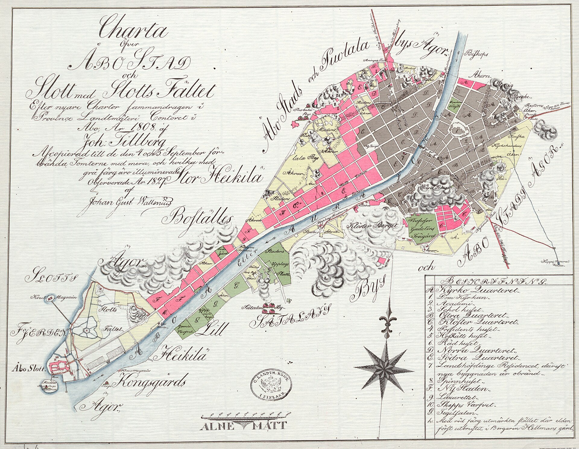
Charta öfver Åbo stad och Slott med Slottsfältet (Town plan of Åbo / Turku)
Shows Åbo Slott (Turku Castle), the Aura River, the street grid and building blocks, named church sites and the castle field, with the area later affected by the 1827 fire indicated.
1808 · Maanmittaushallitus. · Wikimedia Commons
CC BY 4.0 (plate dated 1808)
Castles of Turku

More cities to explore
 FinlandHelsinkiExplore it in 1750 · 1900
 EstoniaTallinnExplore it in 1450 · 1560 · 1900
 NetherlandsUtrechtExplore it in 1400 · 1700
 EnglandLondonExplore it in AD 200 · 1390 · 1600 · 1885
Castles of Europe · Landmarks of Europe · create your own reconstruction.