Historic Cities · Ireland
Galway through the ages
Galway is a city in County Galway. It lies on the River Corrib between Lough Corrib and Galway Bay. It is the most populous settlement in the province of Connacht, the fifth most populous city on the island of Ireland and the fourth most populous in the Republic of Ireland, with a population at the 2022 census of 85,910.

Galway in 1580
City of the Tribes
Galway in 1580 is a tightly walled Atlantic merchant town, ruled by its oligarchy of merchant families and shaped by trade with Spain and France. The walk follows the harbour and quays where Iberian ships land wine and salt, moves through narrow cut‑stone streets past Lynch's Castle and St Nicholas', and reaches the thatched Claddagh fishing village at the Corrib mouth.
The skyline is a low, compact band of grey cut stone and stepped gables interrupted by the square tower of St Nicholas' Collegiate Church and the stout rounders of the city wall. The quay is busy with clinker and caravel hulls, deck crews shifting casks of wine and sacks of salt, while carved stone coats of arms mark merchant houses and the distant Claddagh shows a scatter of low thatch and drying nets.
The route: 22 streets, squares and views
Galway Bay at the Corrib Mouth → The Twelve Mills → West Gate → Merchants' Quay → Spanish Arch → Quay Street → The Salt‑House → Fish Market → Spanish Merchant Slip → Lynch's Castle → …
Step inside, 12 interiors
Millstone Chamber · Gatehouse Guardroom · Vaulted Wine Cellar · Salt Store Vault · Covered Fish Shambles · Ship's Cargo Hold · Carved Stone Hall · Draper's Counting Room · Guild Merchant Hall · Tolbooth Council Chamber · Nave and Aisles · Monastic Refectory
Planned from the Wikipedia record: History of Galway.
Galway in 1900
Claddagh Galway
Galway at the turn of the twentieth century remains a working west-coast port where old fishing customs live alongside Victorian institutions. This walk moves from the bay and the Claddagh's whitewashed, partly thatched village through the docks, markets and medieval streets to the university quadrangle and the salmon weir beneath the bridge.
Stone medieval walls and low harbour warehouses meet the broad sweep of Galway Bay; whitewashed cottages with some thatch cluster at the Claddagh while long rows of grey stone and slate roofed public buildings shape the town proper. Narrow cobbles and quays smell of sea and fish; carts from Connemara arrive with peat and produce, horse drays and red‑sailed hookers share the water, and the university's quadrangle reads as a cool granite bookend to the busy streets.
The route: 21 streets, squares and views
Galway Bay → Spanish Arch → Fish Quay → Claddagh Village → Claddagh Pier → Claddagh Hookers → The Long Walk → Quay Street → Shop Street → Lynch's Castle → …
Step inside, 14 interiors
Harbour Master's Office · Merchants' Storehouse · Fish Market Hall · Claddagh Cottage Hearth · Hookers' Sail Loft · Coopers' Workshop · King's Head Taproom · Merchant Great Hall · Collegiate Nave · Market Exchange Hall · Customs Counting Room · Weir Keeper's Shed · Convocation Hall · Railway Booking Hall
Planned from the Wikipedia record: History of Galway.
Its story
The story of Galway.
Dún Bhun na Gaillimhe, 1124–1232
The city takes its name from the river Gaillimh, the word meaning stony, as in stony river; the stream is now commonly called the Corrib, after the lough to the north. The often-repeated derivation from Gallaibh, meaning foreigners, is incorrect, since the name Gaillimh belonged to the river before it belonged to the town. A separate account makes the river the namesake of Gailleamh, a local chieftain's daughter who drowned in it, her father camping at the spot to mourn her.
Dún Bhun na Gaillimhe, the fort at the mouth of the Gaillimh, was built in 1124 as a naval base and military fort by Tairrdelbach Ua Conchobair, King of Connacht and High King of Ireland, who anchored his fleet there. The Annals of the Four Masters record for that year that “Three castles were erected by the Connaughtmen, the castle of Dun-Leodhar, the castle of the Gaillimh, and the castle of Cuil-maeile”. It was attacked in 1132 and again in 1149. The ground lay in the túath of Clann Fhergail, held by the Ó hAllmhuráin, within the wider territory of Uí Bhriúin Seola; the Ó Flaithbheartaigh are often recorded as holding it for the O'Connor kings of Connacht until the Norman invasion of Connacht in the 1230s. A week-long siege failed in 1230, and in 1232 Richard Mor de Burgh took the fort.
The Tribes and Their Charters, 1333–1485
Galway thrived under the de Burghs, or Burkes, in the century after the conquest. When the de Burgh dynasty sundered in 1333, the townsmen (wanting control of their own affairs, free of the Gaelicised and often feuding Burkes) sought autonomy, and in 1396 the Crown granted a murage charter, the authority to build a defensive wall. A municipal charter followed in December 1484, securing the town's independence from the Clanrickard Burkes, and the creation of the wardenship of Galway put the large parish church of St Nicholas under the townsmen's control. Peirce Lynch Fitzjohn was elected the first mayor in 1485.
Power lay with an oligarchy of fourteen merchant families, twelve of Norman and two of Irish origin, known as the Tribes of Galway, who kept the town culturally and politically aloof from the Gaelic and Gaelic-Norman country around it without being isolated from it. Galway was the only medieval city in the province of Connacht, and the population of the medieval town is thought to have been about 3,000.
The Spanish Trade and the Laws Against the Irish, 1460–1588
The town lived on international trade. In the Middle Ages it was the principal Irish port for trade with Spain and France, and the main source of trade to the Western Isles of Scotland during the Lordship of the Isles. The length of wall called ceann an bhalla, the end of the wall, now known as the Spanish Arch, was built during the mayoralty of Wylliam Martin in 1519–20. Christopher Columbus visited in 1477, possibly stopping off on a voyage to Iceland or the Faroe Islands; seven or eight years later he noted in the margin of his copy of Imago Mundi that at Galway “a man and a woman, of extraordinary appearance, have come to land on two tree trunks”, most likely Inuit carried east on the North Atlantic Current.
Relations with the Irish outside the walls were governed by statute. A bylaw of 1460 forbade any resident to sell or lease land or tenement within the town to an Irishman without the council's licence, on pain of forfeiting the property and a hundred shillings; another barred the native Irish from unrestricted entry, in the phrase that “neither O' nor Mac shall strutte nor swagger through the streets of Galway”. The notice completed over the west gate in 1562 by Mayor Thomas Óge Martyn read “From the Ferocious O'Flahertys may God protect us”. The town assimilated to its Gaelic surroundings all the same, and an Act of Henry VIII of 1536 ordered the inhabitants to shave their moustaches, wear English caps and clothes cut in the English fashion, use no saffron in their garments, speak English, and put their children to school to learn it.
Sir Henry Sidney wrote in 1576 that he found the town “moche decaied” through “the horribl spoyle done upon them by the sonnes of the earle of Clanrickrd”, with fifty householders of Galway by then living under a local Irish lord; three years later Sir William Pelham's party found it “well bulte, and walled, with an excellent good haven, and is replenished with many welthie merchants”. A new charter required that ships of strange merchants entering the haven be searched for weapons and munitions, and that no more than ten of a ship's company come into the town. Loyalty to the Crown made Galway an occasional administrative centre for the English authorities: the annals record the Lord Deputy Sir Richard Bingham executing seventy men and women there in January 1586, and in 1588 the Lord Deputy Sir William Fitz-Williams had a number of Spanish Armada survivors beheaded near St Augustine's Monastery. A memorial at Fort Hill Cemetery records more than 300 Armada sailors executed en masse and buried there in the 1580s.
Confederates, Cromwell and the Articles of Galway, 1641–1691
After the Irish Rebellion of 1641 the town stood between the Catholic Confederates and the English garrison at Fort Hill just outside it. Galway's citizens, predominantly Catholic, turned against the garrison in 1642 and supported the Confederate side; the fort was besieged with the aid of Confederate troops until it surrendered and its garrison was evacuated by sea. The city was heavily fortified through the 1640s against the counter-attack that came when English Parliamentarian forces reconquered Ireland in 1649–52. Galway surrendered to Cromwellian forces in 1652 after a nine-month siege, and plague and the expulsion of Catholic citizens followed. The Cromwellian Act of Settlement of 1652 transplanted people from east of the Shannon into Connacht.
Trade recovered somewhat after the Restoration of 1660 and the further Act of Settlement of 1662 and Act of Explanation of 1665. In the crisis over the deposition of the Catholic James II, Galway took the Jacobite side, and in 1691, after the main Jacobite army was annihilated at nearby Aughrim, the city passed to the Williamites under the Articles of Galway. Its great merchant families were ruined and their capital was spent overseas; the city became an economic backwater, and it took about 300 years to regain its former standing.
The Popery Act, the Famine and the Railway, 1704–1850
As a Catholic port city Galway was treated with great suspicion after the seventeenth-century wars. The Popery Act of 1704 barred new Catholics other than seamen and day labourers from moving there, and when a French invasion of Ireland was feared in 1708 and again in 1715, during the Jacobite rising in Scotland, all Catholics were ordered to leave the city. The corporation that ran Galway was confined to Protestants, although a census of 1762 found only about 350 Protestants among some 15,000 inhabitants. The persecution of the old Catholic merchant elite cut trade substantially and the once busy harbour fell into disrepair; local traders made up part of the loss by smuggling goods such as brandy through gaps in the town walls. On 1 November 1755 the Lisbon earthquake sent a two-metre tsunami onto the city's coast, seriously damaging the Spanish Arch section of the wall.
The economy recovered somewhat from the late eighteenth century as the Penal Laws were relaxed, and the Roman Catholic diocese of Galway was created in 1831 after the Holy See abolished the wardenship. The city's rural hinterland then suffered terribly in the Great Irish Famine of the 1840s, and unlike other Irish urban centres, whose populations grew through the nineteenth century, Galway's declined. Queen's College, Galway was created in 1845 as one of the three colleges of the Queen's University of Ireland, its original quadrangle erected in 1849 during the Famine, and the railway lines reached the city in 1850.
Easter Week to the Civil War, 1916–1923
Galway city played a relatively minor part in the upheaval between 1916 and 1923. During the Easter Rising in 1916 Liam Mellows mobilised the local Irish Volunteers to attack the Royal Irish Constabulary barracks at Oranmore, just outside the city; they failed to take it and surrendered later at Athenry. In the War of Independence of 1919–21 the city was the western headquarters of the British Army, whose overwhelming strength left the local IRA able to do little against it; the university battalion's initiatives drew a reprimand from the local IRA commander, who feared the reprisals that had seen the Black and Tans sack nearby Tuam twice, in July and September 1920. In November 1920 a Galway city priest, Fr Michael Griffin, was abducted and shot by British forces, and his body was found in a bog at Barna. From December 1919 Galway businessmen ran a boycott of Northern Irish goods in protest at loyalist attacks on Catholic nationalists in Belfast, a protest that later spread throughout the country.
In March 1922, before the Civil War broke out, pro-Treaty and anti-Treaty troops faced each other in a tense stand-off over the military barracks at Renmore. After fighting began in July 1922 the National Army of the Irish Free State occupied the city and the barracks, at the cost of two Free State soldiers and one anti-Treaty fighter killed and more wounded; the Republicans burned a number of public buildings in the centre before abandoning Galway.
Borough, Fire and Capital of Connacht, 1937–2024
The urban district became the Borough of Galway in 1937, the County Borough in 1986, when it ceased to be part of County Galway, and Galway City in 2001. A fire on 16 August 1971 destroyed a large part of the centre, from Merchants Road to Williamsgate Street and Eyre Square; the burnt ground was redeveloped as the Eyre Square, Corbett Court and Edward Square shopping centres. Galway Textile Printers on Sandy Road, the first major industry to come to the city and one of the biggest employers in the west of Ireland, went out of business in the early 1980s. The resignation of Eamon Casey as Bishop of Galway in 1992, in what were described as scandalous circumstances, came to be seen as pivotal in the Roman Catholic Church's loss of influence in Ireland.
The Claddagh, on the west bank of the Corrib where it meets the sea, was for centuries an Irish-speaking fishing settlement outside the walls, governed by an elected King who arbitrated disputes among the locals and held the privilege of a white sail on his boat; the last holder of the title died in 1972 and the office is now honorary. Galway is the county town of County Galway and the capital of Connacht, and at the 2022 census had 85,910 people, the most populous settlement in the province. Its economy runs on manufacturing, much of it medical equipment, electronics and information technology, together with tourism, retail, education and health, and the University of Galway enrolled more than 19,000 students in 2024. The city was named European Region of Gastronomy in 2018 and was European Capital of Culture in 2020, alongside Rijeka in Croatia.
From the archive
Galway on paper: the old town as it was mapped.
A period plan or bird's-eye view of the old town, drawn between 1500 and 1850, the streets this page's reconstructions walk. Public domain, with its source named.
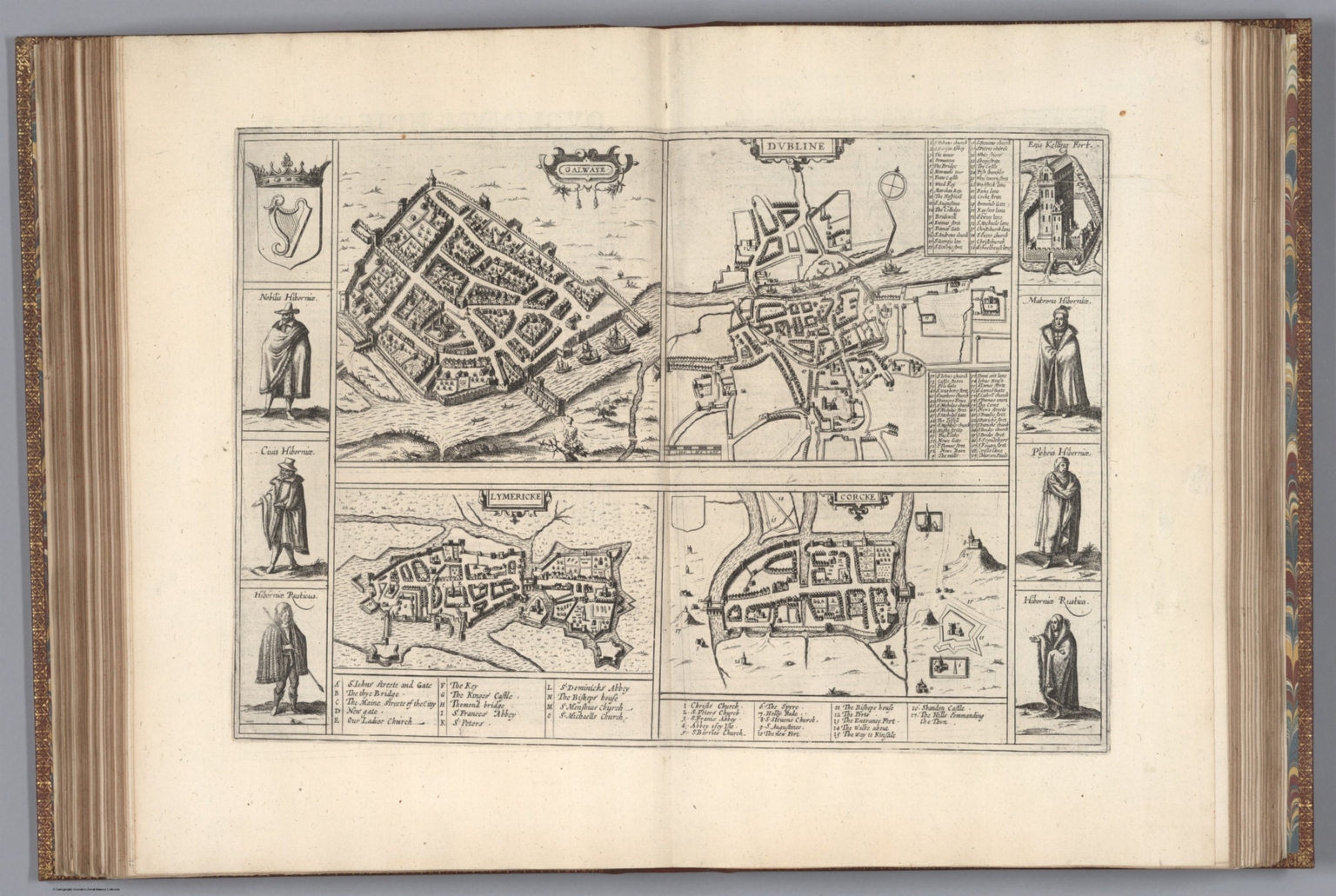
Bird's-eye view of Galwaye (Galway), from Braun & Hogenberg's Civitates Orbis Terrarum
Walled bird's-eye plan showing Galway’s streets and rectilinear blocks, defensive walls and bastions, the harbour with ships, and the river with a bridge.
Public domain (plate dated 1635)
Castles of Galway


More cities to explore
 IrelandKilkennyExplore it in 1620
 IrelandCorkExplore it in 1600 · 1880
 IrelandDublinExplore it in 1000 · 1780 · 1904
 IrelandBelfastExplore it in 1800 · 1911
Castles of Europe · Landmarks of Europe · create your own reconstruction.