Historic Cities · Italy
Pompeii through the ages
Pompeii was a city in what is now the municipality of Pompei, near Naples, in the Campania region of Italy. Along with Herculaneum, Stabiae, and many surrounding villas, it was buried under 4 to 6 m of volcanic ash and pumice in the eruption of Mount Vesuvius in 79 AD.

Pompeii in AD 79
Pompeii before Vesuvius
Pompeii in AD 79 is a prosperous Campanian town of shops, baths, markets and temples beneath the green bulk of Vesuvius. This walk moves from the coastal approach through gates, along the main street and into the forum district, past public baths, theatres, the amphitheatre and the palaestra, ending on the city walls with a wide view toward the mountain.
Low stone houses and two‑storey townhouses cluster within limestone and tufa walls; colonnaded public buildings and temple porticoes puncture a low horizon. Streets are paved with worn basalt blocks and deep cart ruts; painted shopfronts and brightly frescoed façades add red, yellow and white to sunlit dust. Wells and stone fountains mark crossroads. Mount Vesuvius rises green and cultivated just beyond the city, forming an ever‑present backdrop.
The route: 23 streets, squares and views
Coastal Plain Approach → Road to the Port → Porta Marina → Via Marina → House of the Faun (Front) → Via dell'Abbondanza → Thermopolium Counter → Street Bakery → Crossroads Fountain → Stabian Baths → …
Step inside, 14 interiors
Atrium with Impluvium · Triclinium with Alexander Mosaic · Taberna with Painted Notices · Thermopolium Counter with Dolia · Bakery Milling Room and Oven · Caldarium Hot Room · Apodyterium Changing Room · Theatre Cavea and Stage · Roofed Odeon Auditorium · Cella of Jupiter · Basilica Judicial Hall · Covered Meat Hall · Palaestra Colonnaded Courtyard · Amphitheatre Arena and Passages
Planned from the Wikipedia record: Pompeii.
Pompeii in 1800
Grand Tour Pompeii
This is Pompeii in the age of Bourbon excavations, a buried Roman town half-revealed by the work of mid‑18th‑century diggers and visited by Grand Tour artists. The walk shows half‑cleared streets running into banks of earth, newly exposed temples and theatres, spoil heaps and tool shelters, with Vesuvius smoking beyond the open ruins.
Low sun casts long shadows across dusty streets hemmed by fluted column bases, broken walls and banks of spoil, while patches of broom, vines and fig saplings cling to the unexcavated blocks. Exposed marble, tufa and brick shelters gleam pale against rusting wheelbarrows; the amphitheatre and theatres appear as cut stone stages among terraces of earth with Vesuvius looming, a dark, smoking cone on the horizon.
The route: 21 streets, squares and views
Sarno Plain View → Porta Marina → Via dell'Abbondanza → Macellum (Market) → Foro (Forum) → Basilica → Capitolium (Temple of Jupiter) → Eumachia Building → Temple of Isis → Foro Triangolare → …
Step inside, 12 interiors
Macellum Central Hall · Antiquarian's Cabinet of Bronzes · Basilica Nave and Tribunal · Cella of Jupiter · Hall of Eumachia · Inner Sanctuary of Isis · Frigidarium of the Stabian Baths · Caldarium of the Central Baths · Stagehouse of the Large Theatre · Peristyle Mosaic Court · Sanded Arena of the Amphitheatre · Excavators' Shelter and Finds
Planned from the Wikipedia record: Pompeii.
Its story
The story of Pompeii.
Five Villages Above the Sarno Mouth
Pompeii sat about 40 metres above the sea on a lava plateau thrown up by earlier eruptions of Vesuvius, eight kilometres away. Beside it lay the mouth of the navigable Sarno, sheltered by lagoons, which served Greek and Phoenician sailors as a haven long before the Romans developed it. The first stable settlements date to the 8th century BC, when the Oscans, a people of central Italy, founded five villages here. The root of the name appears to be the Oscan word for five, pompe, suggesting either that the community was made up of five hamlets or that it was settled by a family group, the gens Pompeia.
In the early 6th century BC those settlements merged into one community on the crossroad between Cumae, Nola and Stabiae, enclosed by a tufa wall. That first circuit took in a far larger area than the town itself, including much farmland, and its scale indicates a settlement already wealthy. A small port was built near the river mouth and maritime trade began.
Greeks, Etruscans and Samnites, 740–300s BC
From about 740 BC, with the arrival of the Greeks in Campania, Pompeii entered the Hellenic orbit; the chief building of the period was the Doric Temple, put up away from the centre in what later became the Triangular Forum, and the cult of Apollo was introduced at the same time. By 524 BC the Etruscans had settled in the area, using the Sarno as a route between the sea and the interior, and Pompeii became a member of the Etruscan League of cities. Neither people took the town militarily; both simply controlled it, and Pompeii kept a degree of autonomy.
In 474 BC the Greek city of Cumae, allied with Syracuse, defeated the Etruscans at the Battle of Cumae and took the area. From about 450 to 375 BC large parts of the town were abandoned, and sanctuaries such as the Temple of Apollo show a sudden absence of votive offerings. The Samnites, from Abruzzo and Molise, took Greek Cumae between 423 and 420 BC, and the surrounding territory including Pompeii was probably already theirs by about 424 BC. They imposed their own architecture, and in the late 4th century BC building spread from the old nucleus into the open ground inside the walls.
Rome's Ally, Then Sulla's Target, 290–89 BC
After the Samnite Wars, from 290 BC, Pompeii was obliged to accept the status of a socius of Rome while keeping its own language and administration. It stayed loyal through the Second Punic War from 218 BC, unlike many southern cities, and strengthened its walls against Hannibal's invasion. Despite the uncertainty, and a steady drift of wealthy men to quieter cities in the eastern Mediterranean, the town prospered on the production and trade of wine and oil, shipped as far as Provence and Spain, and on intensive farming on the estates around it. A statue of Apollo set up in the Forum by Lucius Mummius, in thanks for Pompeian support during the sack of Corinth, marks the profits taken from Rome's conquest of the east.
Pompeii was among the Campanian towns that rebelled against Rome in the Social War, and in 89 BC it was besieged by Sulla, whose artillery concentrated on the vulnerable Porta Ercolano; the craters left by thousands of ballista shots are still visible in the walls. The Social League troops under Lucius Cluentius helped hold the Romans off, but the town surrendered after Nola fell. It was made a Roman colony, Colonia Cornelia Veneria Pompeianorum. Sulla's veterans were given land and property in and around the town, and many of those who had opposed Rome were stripped of theirs. The Pompeians were nonetheless granted Roman citizenship, Latin became the main language, and many of the old aristocratic families Latinised their names.
Wine, Wool and Garum in the Roman Colony
The colony lived off the fertility of the volcanic soil and off the passage of goods that came in by sea and went on towards Rome or southern Italy by the nearby Appian Way. Barley, wheat and millet were grown alongside wine and olive oil for export, and Pompeian wine bottles have been recovered in Rome. Inside the walls the work was industrial in scale for a town of this size: at least 31 bakeries with wood-burning ovens and millstones; close to a hundred thermopolia selling hot food and drink; thirteen workshops handling raw wool, seven spinning, nine dyeing and eighteen washing it; and a workshop making garum, the sauce fermented from fish entrails. The Building of Eumachia, named for the priestess who paid for it, served as the wool market or the seat of the fullers' guild.
From about 20 BC a spur of the Serino Aqueduct, built by Marcus Vipsanius Agrippa, brought running water to the public baths, to more than 25 street fountains and to private houses. In AD 59 a riot between Pompeians and Nucerians in the amphitheatre left many dead, an event painted on a fresco and reported to Rome, and the Senate sent the Praetorian Guard to restore order and banned further games for ten years. One explanation offered for the fight is the damage done to Pompeii's trade when Nuceria was raised to colonial status in 57; another is political.
The Earthquake of 62 and the Eruption of 79
Tremors were routine here (Pliny the Younger wrote that they "were not particularly alarming because they are frequent in Campania"), but the shock of 5 February 62 did serious damage around the bay and particularly to Pompeii, with fires spreading from oil lamps knocked over in the chaos. Much of the rebuilding that followed was private, with damaged frescoes painted over, while the east side of the Forum was restored in marble and the Central Baths begun from scratch on a whole insula of demolished houses. Nor was the decade free of disorder: Vespasian had to send the tribune Titus Suedius Clemens to settle the illegal occupation of municipal land by private owners.
The eruption of AD 79 lasted two days. The first phase, about eighteen hours of falling pumice, allowed most of the inhabitants to get out, many carrying valuables; skeletons have been found with jewellery, coins and silverware. During the night or early the next day pyroclastic flows began, dense scorching ash clouds that knocked down structures in their path and killed those who had stayed. A study published in 2010 concluded that heat, not suffocation, was the main cause of death: flows of at least 250°C ten kilometres from the vent killed instantly, even indoors. Excavation in 2023 showed that some buildings collapsed in earthquakes during the eruption, killing the people inside. About 1,150 bodies have been recovered, and population estimates differ sharply, from 10,000 to 20,000 on older reckonings down to 11,000–11,500 on household counts.
The date is disputed. Pliny the Younger, writing from Misenum across the bay some 27 or 28 years afterwards, left the only first-hand account; one version of his letter placed the eruption in August, another as late as 23 November. A charcoal inscription found at the site in 2018 carries the date 17 October and must have been written shortly before the burial, and a collaborative study in 2022 settled on 24–25 October. Pliny the Elder, admiral of the fleet at Misenum, ordered his ships across the bay to help with the evacuation and died in the attempt.
Salvage, La Civita and Rediscovery, AD 79–1763
Titus appointed two ex-consuls to organise relief and gave heavily from the imperial treasury; he visited twice, but no recovery work was done. The town was not wholly buried (the tops of the larger buildings still showed above the ash), and survivors and thieves came back for marble statues from the Forum and other valuable material, cutting holes through walls and leaving one wall marked "house dug". The site was reoccupied as a small informal settlement that lasted into the fifth century. Its name and location were then forgotten, although it still appeared on the Tabula Peutingeriana in the 4th century, and further eruptions in 471–473 and 512 covered the remains more deeply. The ground came to be known as La Civita, the city.
In 1592 the architect Domenico Fontana, cutting an underground aqueduct to the mills of Torre Annunziata, ran his channel straight through the buried town and struck ancient walls bearing paintings and inscriptions. He kept the discovery to himself. In 1689 Francesco Picchetti saw an inscription reading decurio Pompeiis, town councillor of Pompeii, but took it for a villa of Pompey; Francesco Bianchini identified its real meaning, and Giuseppe Macrini wrote in 1693 that Pompeii lay beneath La Civita. After Herculaneum was found in 1738, the Spanish military engineer Roque Joaquín de Alcubierre began digging at Pompeii in 1748, though the town was still not identified. That came on 20 August 1763, with an inscription reading Rei Publicae Pompeianorum.
French Spades, Fiorelli's Casts and the Great Pompeii Project, 1799–2024
Work had moved fastest under French rule (the French occupied Naples in 1799 and governed Italy from 1806 to 1815), when the land was confiscated and up to 700 workers were employed. Giuseppe Fiorelli took charge in 1863 and changed the discipline: realising that the voids in the ash were spaces left by decomposed bodies, he injected plaster into them to recover the forms of the victims, a method still used today with resin in place of plaster. He divided the site into the nine regiones and their insulae, numbered the house entrances, and published the first periodical of excavation reports.
In the 1920s Amedeo Maiuri dug below the levels of 79 for the first time to reach the settlement history, and in the 1950s carried out the last large-scale excavation, clearing almost everything south of the Via dell'Abbondanza but documenting it poorly. Many buildings were badly damaged or destroyed by Allied bombing raids during the Second World War, the Antiquarium among them in 1943, and the earthquake of 1980 caused further destruction. A moratorium on new excavation was imposed in 1999 by the site's superintendent, Pietro Giovanni Guzzo, and lifted in 2017. Two-thirds of the town has been uncovered, and what is exposed decays.
Pompeii was declared a World Heritage Site by UNESCO in 1997. The collapse of the Schola Armatorum in 2010, after heavy rain and inadequate drainage, brought accusations of neglect, and in June 2013 UNESCO warned that without substantial progress within two years the site could be placed on the List of World Heritage in Danger. The Grande Progetto Pompei, begun in 2012 with European Union funding, secured over 2.5 kilometres of ancient walls against collapse and reopened digging in Regio V, which produced in November 2020 two men killed by a second blast the day after surviving the first, thought to be a wealthy man and his slave, the younger man's bones showing the marks of manual labour. The ruins have drawn visitors since the Grand Tour and now take roughly 2.5 million a year; in 2024 the management capped daily sales at 20,000 personalised tickets with timed entry in peak summer.
From the archive
Pompeii on paper: the old town as it was mapped.
A period plan or bird's-eye view of the old town, drawn between 1500 and 1850, the streets this page's reconstructions walk. Public domain, with its source named.
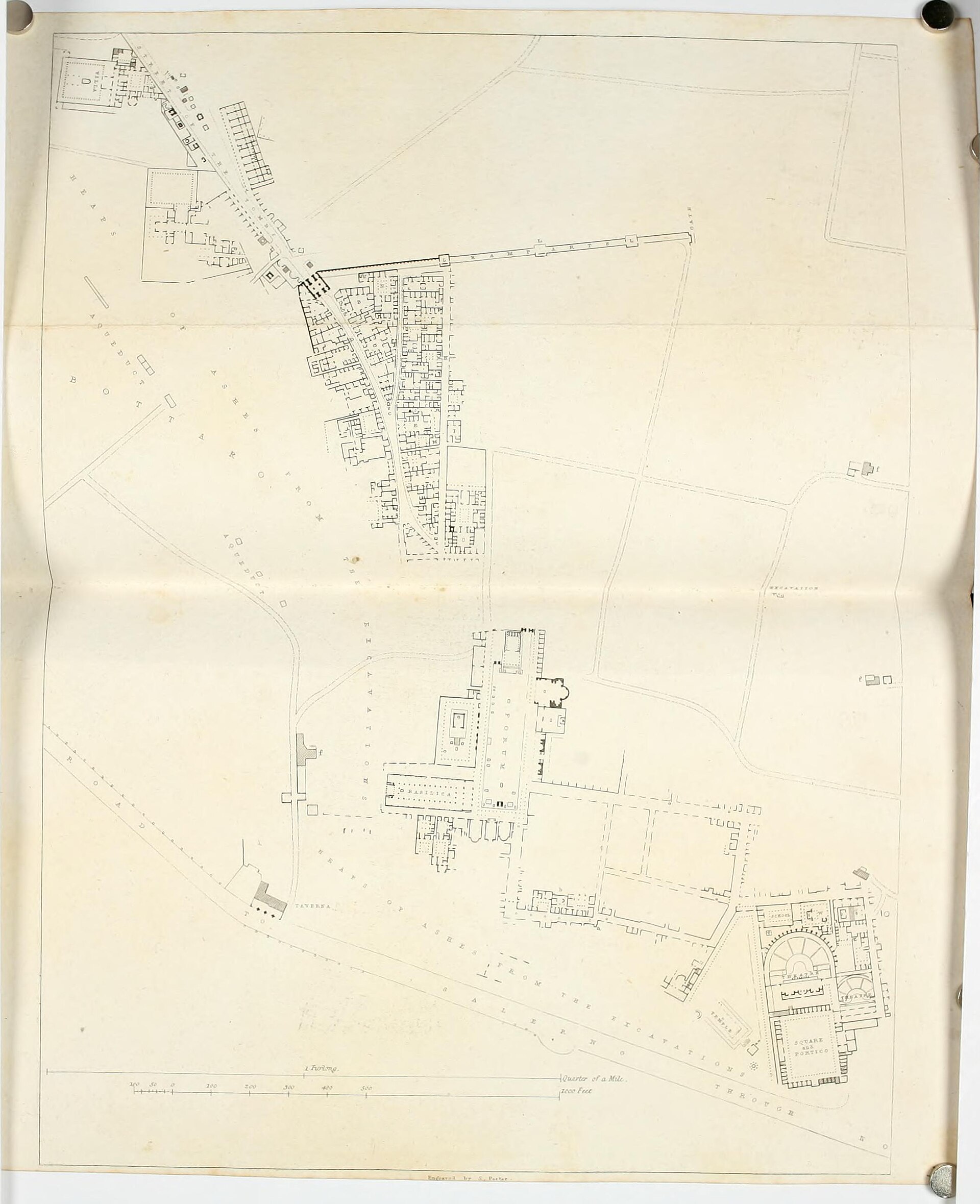
Plan of Pompeii, from Pompeiana: The Topography, Edifices, and Ornaments of Pompeii (Gell, 1817)
Detailed plan showing the forum and basilica complex, theatre and amphitheatre, the street grid and contiguous house blocks with excavated open areas.
No restrictions (plate dated 1817)
In this city
Landmarks of Pompeii, see each in its prime


More cities to explore
 ItalyNaplesExplore it in 1350 · 1650 · 1780
 ItalyMateraExplore it in 1750
 ItalyRomeExplore it in AD 320 · 1300 · 1600 · 1770
 ItalyVeniceExplore it in 1200 · 1500 · 1740
Castles of Europe · Landmarks of Europe · create your own reconstruction.