Historic Cities · Malta
Valletta through the ages
Valletta, also known as Città Umilissima, is the capital city of Malta and one of its 68 council areas. Located between the Grand Harbour to the east and Marsamxett Harbour to the west, its population as of 2021 was 5,157. As Malta's capital city, it is a commercial centre for shopping, bars, dining, and café life.

Valletta in 1600
Knights' Valletta
Valletta is the new fortified capital raised by the Order of St John after the Great Siege; in 1600 the grid of streets, auberges and the Grand Harbour defences are still young. The walk follows the peninsula from the harbour approach up into the city's regimented streets, passing bastions, cavaliers, auberges, the conventual church's plain exterior and the palace, and ends on a high bastion overlooking the Order's galleys below.
A compact bastioned peninsular city cut into pale honey-coloured limestone, Valletta in 1600 shows a tight orthogonal grid of straight streets running down to two harbours. Low- to mid-rise stone houses and the ashlar façades of auberges and the palace punctuate a clear skyline of bastion walls, flat roofs and raised cavaliers. The sea rims the city with oared galleys and small craft; sunlight is bright, wind off the harbour sharp, dust and lime-smell join horse and tarred-rope tang.
The route: 24 streets, squares and views
Grand Harbour Approach → View to Fort St. Angelo → Fort St. Elmo → Valletta Marina → Sacra Infermeria → The Manderaggio → Saluting Battery → Porta Reale (Main Gate) → St Michael's Bastion → St. John's Cavalier → …
Step inside, 12 interiors
Galley Master's Shed · Great Surgical Ward · Porta Reale Guardroom · St John's Casemates · Merchant Exchange Chamber · Conventual Church Nave · Grandmaster's Armoury · Hall of St Michael · Castile Refectory · Provence Refectory · Italian Refectory · France Refectory
Planned from the Wikipedia record: Hospitaller Malta.
Valletta in 1910
Imperial Valletta
Valletta in 1910 is a compact British imperial port where the Mediterranean Fleet keeps grey battleships in the Grand Harbour and the Knights’ baroque palaces serve as offices and messes. The walk moves from the harbour approach up along the bastioned quays and Strada Reale, past the Royal Opera House colonnade and the Barrakka lifts, into the city’s limestone streets and gardens overlooking blue water.
A compact Baroque city of honey‑coloured limestone rising from clear blue harbours; flat roofs, carved balconies and colonnaded façades catch a hard, southern light. Massive seventeenth‑century bastions descend to quays where dghajsa ferries thread between moored grey battleships, customs sheds and slipways. Strada Reale cuts a straight, sunlit spine of shopfronts, officers’ cafés and the Royal Opera House colonnade; gardens on the bastions punctuate the stone with clipped greenery and bronze guns.
The route: 20 streets, squares and views
Grand Harbour Approach → Fort Saint Elmo → Lower Barrakka Gardens → Barrakka Lift Base → Lascaris Wharf → Porta Reale (City Gate) → Strada Reale Entrance → Royal Opera House Colonnade → Strada Reale Café → Auberge de Castille → …
Step inside, 13 interiors
Quay Customs Office · Lift Ticket Hall · Victualling Office · Opera House Auditorium · Strada Reale Officers' Café · Admiralty Mess Hall · Tapestry Chamber · Main Guard Guardroom · Cathedral Nave and High Altar · Army Officers' Mess Room · Dockyard Riveting Workshop · Lascaris Casemate Magazine · Saluting Battery Magazine
Planned from the Wikipedia record: Crown Colony of Malta.
Its story
The story of Valletta.
Sceberras, the Headland Before the City
The peninsula between the two harbours was called Xagħret Mewwija (a name given in the Arab period, from Mu'awiya or Meuia), or Ħal Newwija, mewwija meaning a sheltered place. Some authors record that its far end was known as Xebb ir-Ras, after the lighthouse there. A family that held land on it became known as Sceberras, surviving as the Maltese surname Sciberras, and in time the whole peninsula took that name; recent scholarly work argues instead that Xeberras is Punic and means the headland, or the middle peninsula, which is what it is.
The Order of Saint John proposed building a city on the Sciberras peninsula as early as 1524. At that date its only structure was a small watchtower dedicated to Erasmus of Formia (Saint Elmo) put up in 1488. In 1552 that Aragonese tower was demolished and the larger Fort Saint Elmo built in its place.
Founded After the Great Siege, 1565–1571
In the Great Siege of 1565 Fort Saint Elmo fell to the Ottomans, but the Order won the siege with the help of Sicilian reinforcements. The victorious Grand Master, Jean de Valette, at once set about building a fortified city on the peninsula, to secure the Order's position and tie the Knights to the island, a decision that committed them to staying in Malta for good. The new city was to defend both the Grand Harbour and Marsamxett. It took his name, La Valletta, and the Order gave it the title Humilissima Civitas Valletta, the most humble city; the bastions and the Baroque streets that followed earned it the opposite epithet among Europe's sovereigns, Superbissima, the proudest.
De Valette asked the kings and princes of Europe for help and received a great deal of it, the Order's fame having risen after the siege. Pope Pius V sent his military architect, Francesco Laparelli, to design the city; Philip II of Spain sent substantial money. De Valette laid the foundation stone on 28 March 1566, on the site that became the Church of Our Lady of Victories. Writing between 1594 and 1602, Giacomo Bosio recorded that as the cornerstone went down a group of Maltese elders said that a time would come when every span of land on Sciberras hill would be worth its weight in gold. De Valette died of a stroke on 21 August 1568, aged 74, and never saw the city finished; buried first in Our Lady of Victories, his remains were later moved to St John's Co-Cathedral, among the tombs of other Grand Masters.
Laparelli broke with the winding lanes of medieval Maltese building and set the city on a rectangular grid, with no collacchio reserved for the Order's own buildings. The streets ran wide and straight from the City Gate down to the rebuilt Fort Saint Elmo, the central one (Strada San Giorgio, now Triq ir-Repubblika) running some 900 metres; certain bastions were raised 47 metres. His assistant was the Maltese architect Girolamo Cassar, who took charge of construction after Laparelli's death in 1570, and a planning authority, the Ufficio delle Case, regulated the building. The city was largely complete by the early 1570s and became the capital on 18 March 1571, when Grand Master Pierre de Monte left Fort St Angelo in Birgu for the Grandmaster's Palace.
The Auberges, the Infirmary and the Floriana Lines
Seven auberges were built for the Order's Langues and were finished by the 1580s; an eighth, the Auberge de Bavière, was added in the eighteenth century. The Sacra Infermeria, built in 1574, was one of Europe's most renowned hospitals of the Renaissance. Under Antoine de Paule the Order decided to add outer fortifications, named the Floriana Lines after their designer, Pietro Paolo Floriani of Macerata. In António Manoel de Vilhena's reign a settlement grew in the ground between those lines and Valletta's own walls, and became the town of Floriana. Vilhena also ordered the Manoel Theatre, put up in ten months in 1731 and among the oldest working theatres in Europe.
Behind the Manderaggio Curtain the Order had meant to cut a small harbour, a mandracchio, for shipping. The work failed, and the excavated ground filled instead with poor housing in bad sanitary condition, the Manderaggio, which was eventually cleared and replaced with housing estates.
Explosion, Slave Plot and Revolt, 1634–1775
A gunpowder factory explosion killed 22 people in Valletta in 1634. In 1749 Muslim slaves plotted to kill Grand Master Pinto and seize the city; their plans leaked to the Order and the rising was put down before it began. Later in his reign Pinto embellished the city with Baroque architecture, and important buildings such as the Auberge de Castille were remodelled or wholly rebuilt. It was he who built the old seawall along what is now the Valletta Waterfront. In 1775, under Grand Master Ximenes, rebels in the revolt known as the Rising of the Priests seized Fort Saint Elmo and Saint James Cavalier before being suppressed.
The French Expelled, the British Installed, 1798–1931
The French invaded in 1798 and expelled the Order. When the Maltese rebelled, French troops held on to Valletta and the harbour area until they capitulated to the British in September 1800. Early in the nineteenth century the British Civil Commissioner, Henry Pigot, agreed to demolish most of the city's fortifications; demolition was proposed again in the 1870s and 1880s but never carried out, and the walls survive largely intact.
Valletta had been run since 1577 by its own municipal council, the Università, seated in the Banca Giuratale. In 1818 the British colonial governor Thomas Maitland suppressed it and took full control of Malta's administration; local government was not restored for another 175 years. Building work in the city resumed under British rule: gates widened, structures pulled down and rebuilt, civic works installed. The Malta Railway, linking Valletta to Mdina, opened in 1883 and closed in 1931 once buses had taken its traffic. The city's carnival, held each February before Lent, was the scene in 1823 of a crush in which at least 110 boys died.
The Siege of Malta and the Emptying of the City, 1939 Onwards
In 1939 Valletta was abandoned as headquarters of the Royal Navy's Mediterranean Fleet because it lay too close to Italy, and the city became a flash point in the two-year Siege of Malta that followed. German and Italian air raids destroyed a great deal of Valletta and the harbour area; among the buildings lost was the Royal Opera House, built at the city entrance in 1866. Strait Street, also known as The Gut, was where jazz was introduced to Malta; Allied sailors frequented it in both world wars.
The city's population fell sharply after the war, as families and individuals left Valletta for newer and more comfortable housing in other localities. Its population was 5,157 in 2021 and 5,226 in July 2024, of whom 4,400 were Maltese nationals and 826 foreign nationals, against a daily working and visiting population reckoned at around 38,000.
World Heritage Listing and a Council Restored, 1980 Onwards
UNESCO recognised the whole city as a World Heritage Site in 1980, under two of the ten selection criteria: as a masterpiece of human creative genius (an idealistic late-Renaissance creation with a uniform urban plan drawn on Neoplatonic principles, walled around its natural approaches), and for its association with the Order of the Knights of St John, who built it in 1566 and maintained and adorned it for nearly two and a half centuries. Its 320 monuments stand within 0.55 square kilometres, one of the most concentrated historic areas in the world. Because the peninsula is narrow and water-bound, the city's perimeter has barely changed since the Knights left. In 2015 the Maltese heritage body Din l-Art Ħelwa warned the authorities that a proposed forty-storey hotel at Tigné could cost Valletta that status by disfiguring the townscape.
Local administration returned with the Local Councils Act of 1993, the first Valletta council election being held on 20 November 1993. Valletta remains Malta's administrative and commercial centre: the Auberge de Castille houses the Office of the Prime Minister, the Grandmaster's Palace the Office of the President, and the Parliament of Malta has sat in the Parliament House by the city gate since 2015, having previously met in the palace. The city hosted the Valletta Summit on Migration on 11 November 2015, at which European and African leaders discussed the migrant crisis, and part of the Commonwealth Heads of Government Meeting later that month, and was European Capital of Culture in 2018.
From the archive
Valletta on paper: the old town as it was mapped.
A period plan or bird's-eye view of the old town, drawn between 1500 and 1850, the streets this page's reconstructions walk. Public domain, with its source named.
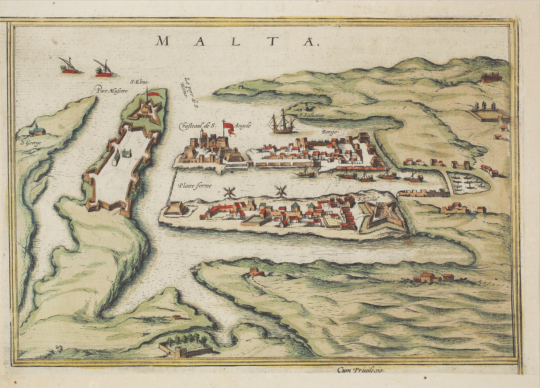
Bird's-eye view of Valletta, from Braun & Hogenberg's Civitates Orbis Terrarum (Cologne, 1597)
Shows Valletta's grid street plan, bastioned walls and Fort St Elmo on the peninsula, with the Grand Harbour and defensive chain across the harbour.
1597 · Unknown author Unknown author · Wikimedia Commons
Public domain (plate dated 1597)


More cities to explore
 MaltaMdinaExplore it in 1550
 ItalyPalermoExplore it in 1160 · 1620 · 1900
 NetherlandsUtrechtExplore it in 1400 · 1700
 EnglandLondonExplore it in AD 200 · 1390 · 1600 · 1885
Castles of Europe · Landmarks of Europe · create your own reconstruction.