Historic Cities · England
Durham through the ages
Durham is a cathedral city and civil parish in County Durham, England. It is the county town and contains the headquarters of Durham County Council, the unitary authority which governs the district of County Durham. The built-up area had a population of 50,510 at the 2021 Census.

Durham in 1400
Shrine of St Cuthbert
Durham in 1400 is the prince‑bishops' rock: a cathedral and castle clasped on a wooded peninsula around a deep loop of the River Wear, drawing pilgrims and power to the shrine of St Cuthbert. This walk follows the river and the town’s bridges, streets and greens to the cathedral slopes, showing mills under the weir, bridge chapels and Sadler Street inns as everyday life clusters beneath the towers.
A compact medieval silhouette: the cathedral’s massive Norman west towers and eastern apses rising from the wooded promontory, the castle’s keep and gatehouse standing close by, and the Wear twisting in a narrow stone gorge below. Stone bridges crowded with shops and small chapels link the peninsula to the town; timber‑framed houses, slate and lead roofs, millwheels under the weir, orchard terraces and narrow cobbled lanes paint a palette of mellow sandstone, timber and river‑dark roofs.
The route: 17 streets, squares and views
River Wear Meander → Framwellgate Bridge → Framwellgate Chapel → Weir and Mills → Elvet Bridge → Elvet Riverside → Monks' Orchards → Dun Cow Lane → Sadler Street Inns → Market Place → …
Step inside, 9 interiors
Framwellgate Bridge Chapel · Miller's Wheelhouse · Sadler Street Inn Hall · Butchers' Shambles · Castle Great Hall · Monks' Dormitory under Oak Roof · Galilee Chapel with Bede's Tomb · Chapter House · Feretory of St Cuthbert
Planned from the Wikipedia record: Durham Cathedral.
Its story
The story of Durham.
Cuthbert's Coffin and the Peninsula, 995–998
Archaeological evidence suggests settlement in the area from roughly 2000 BC, but the city traces to AD 995, when the community of St Cuthbert (monks from Lindisfarne who had been carrying the saint's remains about the north, partly to keep them from Viking raiders) settled a high peninsula enclosed on three sides by a meander of the River Wear. Cuthbert's body had previously lain at Chester-le-Street. The relics went into the White Church, at first a wooden structure; Bishop Aldhun then had a stone church built, dedicated in September 998. The name records what the site was: the Brythonic dun, a hill fort, with the Old Norse holme, an island. The Normans wrote it Duresme, Latin documents Dunelm.
The 12th-century chronicler Symeon of Durham gave the founding a providential account: Cuthbert's bier halted at the hill of Warden Law and would not move, Aldhun ordered a three-day fast, and the saint appeared to a monk named Eadmer with instructions that the coffin be taken to Dun Holm, a place Aldhun did not know. The Dun Cow, in which the monks meet a milkmaid at Mount Joy searching for her lost cow, is a later elaboration, first documented in The Rites of Durham, an anonymous account of the cathedral published in 1593.
Two Kings in England: the Palatinate, 1069–1836
Norman authority arrived badly. In January 1069 William the Conqueror sent an army under Robert de Comines, believed to have been some 700 cavalry, into Durham. The Northumbrians attacked and destroyed it, killing Comines and every man but one, who was allowed to carry the news back. Resistance spread across northern England, and William answered with the Harrying of the North in 1069–1070, which fell mainly on Yorkshire and largely spared Durham. The castle raised on the peninsula in the 11th century was a projection of Norman power over a rebellious north, and the bishop who commanded from it was appointed by the king to exercise royal authority on his behalf.
From the 1070s until 1836 the bishops governed the County Palatine of Durham. Distance from Westminster let them hold their own parliament, raise armies, appoint sheriffs and justices, administer their own laws, levy taxes and customs duties, create fairs and markets, issue charters, take revenue from mines and mint their own coin. The jurisdiction rested on claims that King Ecgfrith of Northumbria had granted Cuthbert a substantial territory in 684. Matters came to a head in 1293, when the bishop and his steward failed to appear at quo warranto proceedings held by the justices of Northumberland and the bishop argued before parliament that Durham lay outside the bounds of any English shire. The argument appears to have prevailed: by the 14th century Durham was accepted as a liberty receiving royal mandates direct, in effect a private shire with the bishop appointing his own sheriff. The steward of Bishop Antony Bek had already put it plainly in 1299: "There are two kings in England, namely the Lord King of England, wearing a crown in sign of his regality and the Lord Bishop of Durham wearing a mitre in place of a crown". "Prince bishop", useful as the term is for describing what they did, is not a title the bishops themselves would have recognised.
The Crown spent three centuries taking it back. The Jurisdiction in Liberties Act 1535 removed the bishop's power to pardon offences and appoint judicial officers and required indictments to run in the king's name; restrictions on the palatine chancery followed in 1596. The palatinate was formally abolished in 1646, revived after the Restoration with much the same power, and finally vested in the Crown on 5 July 1836. Governing power over the town itself had passed to an elected body the year before, under the Municipal Corporations Act 1835.
Pilgrims, Neville's Cross and the Broken Shrine, 1170–1598
What the medieval city lived on was Cuthbert. His shrine behind the high altar was the most important religious site in England until the martyrdom of Thomas Becket at Canterbury in 1170. The healing attributed to the saint in life was reported to continue after his death, earning him the name "wonder worker of England", and at the first translation of his relics in 698 his body was found to be incorruptible. Apart from a brief return to Holy Island during the Norman invasion the relics have stayed in the city. The bones of Bede are entombed in the same cathedral, founded in its present form in 1093, and drew pilgrims in their own right.
The peninsula's position kept it in the Anglo-Scottish wars, and its castle keep is reckoned the only Norman one never to have suffered a breach. In 1314 the bishopric paid the Scots what is recorded only as a large sum of money not to burn Durham. On 17 October 1346 the Battle of Neville's Cross was fought about half a mile west of the city and ended in a disastrous defeat for the Scots. Two centuries later the shrine that had made the city's name was destroyed from within: Henry VIII curtailed the bishop's powers and in 1538 ordered Cuthbert's shrine pulled down. Plague struck the city in 1544, 1589 and 1598.
Scottish Prisoners in the Cathedral, 1640–1660
The city held to Charles I through the civil war, while the palatinate at large was reckoned to incline towards Parliament; in 1640 the high sheriff of the palatinate undertook to supply the Scottish army with provisions during its stay in the county. Charles came to Durham three times, the last near the end of the war, when he left as Cromwell's forces closed in. After the Battle of Marston Moor on 2 July 1644 the palatinate fell entirely into parliamentary hands.
The damage to Durham came not from assault but from the dismantling of the institution the city lived on. It had always relied on the dean and chapter and the cathedral as an economic force, and the abolition of the Church of England closed them. The office of bishop went too, and with it his residence: Cromwell confiscated the castle and sold it to the Lord Mayor of London, after which it suffered considerable damage and dilapidation. The cathedral was closed in 1650 and used to incarcerate 3,000 Scottish prisoners marched south after the Battle of Dunbar; the graffiti they cut into the interior stone can still be seen. At the Restoration in 1660 John Cosin, a former canon, was appointed bishop and began a major restoration of both buildings.
The Port That Never Was: Carpets, Mustard and Coal, 1758–2005
Durham's merchants spent the 18th century trying to reach the sea. John Smeaton proposed cutting a canal north to the River Team, a tributary of the Tyne near Gateshead; nothing came of it, though the statue of Neptune in the Market Place kept the idea in view. A further proposal in 1758 would have made the Wear navigable from Durham to Sunderland by altering the river's course, but ships were growing too large for it and Sunderland had already become the north-east's main port. The infirmary was founded in 1787, and the same century saw the rise of the trade-union movement in the city.
The first census, in 1801, counted 7,100 people. The Industrial Revolution mostly passed the city itself by. What Durham was known for was carpet making and weaving (most of the medieval weavers had gone by the 19th century, but Hugh MacKay Carpets' factory produced axminster and tufted carpets in the city until it went into administration in April 2005) along with hosiery, mustard and the extraction of coal. The river never carried the ships the merchants wanted; the railway came instead, entering from the south over a Victorian viaduct high above the city.
The Durham Coalfield and the Miners' Gala, since 1841
Coal was the county's main industry until the 1970s, and practically every village around the city had a pit. The number employed in coal mining across the county rose from 15,202 in 1841 to a peak of 157,837 in 1921. Colliery villages were built through the 19th century to house them, and much of the labour came from outside: tens of thousands migrated from Cornwall between 1815 and the outbreak of the First World War, partly because of their experience of tin mining, alongside people from Northumberland, Cumberland, South Wales, Scotland and Ireland. Some were brought in to augment the local workforce, others as strike breakers, or "blacklegs". Miners' cottages in east Durham called "Greenhill" were known locally as "Cornwall", and Easington Colliery still has a Cornish Street.
The first Durham Miners' Gala was attended by 5,000 miners in Wharton Park in 1871, and it remains the largest socialist trade union event in the world. The industry was faltering around the city early in the 20th century: an important seam was worked out in 1927, and in the Great Depression that followed Durham was among the towns that suffered exceptionally severe hardship. Pits kept closing, many miners across the county took part in the strike of 1984–85, and no deep coal mines remain. Gala attendance fell between the end of the strike and the 21st century before growing again, with former colliery communities restoring or replicating banners to march in the parade.
Van Mildert's University and the Modern City, 1832–2025
The last bishop to rule the palatinate founded the institution that took over from the bishopric as the city's economic engine. Durham University was established by Act of Parliament in 1832 through the benevolence of Bishop William Van Mildert and the chapter, and granted a royal charter in 1837; it was one of the first universities to open in England for more than 600 years and is claimed to be the third oldest, after Oxford and Cambridge. Van Mildert gave the castle over to house the first college, University College, and moved to Auckland Castle as his only residence in the county. Bishop Hatfield's Hall followed in 1846, founded specifically for the sons of poorer families, its principal introducing a system new to English university life in which fees for accommodation and communal dining were paid in advance.
The university kept expanding as the coalfield contracted, adding colleges on the Bailey and then four more to the south of the centre between the early 1950s and the early 1970s. It is now a significant regional employer alongside the county council and the national government offices at the land registry and the passport office.
Durham was not bombed during the Second World War. A raid on the night of 30 May 1942 gave rise to the local story of "St Cuthbert's Mist", in which the saint covered castle and cathedral in fog and turned the Luftwaffe away; contemporary eyewitnesses disputed what happened that night. Durham Castle and Cathedral were named a UNESCO World Heritage Site in 1986. The City of Durham district was abolished in 2009 and its responsibilities assumed by Durham County Council as a unitary authority, city status passing to charter trustees who appoint the mayor. The built-up area had a population of 50,510 at the 2021 census, and in 2025 Durham became a UNESCO Learning City, one of twelve in the United Kingdom.
From the archive
Durham on paper: the old town as it was mapped.
A period plan or bird's-eye view of the old town, drawn between 1500 and 1850, the streets this page's reconstructions walk. Public domain, with its source named.
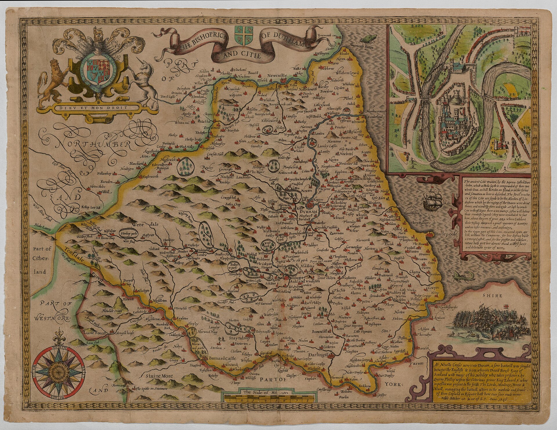
Bird's-eye view of Durham (inset on 'The Bishoprick of Durham and Citie'), by John Speed
Inset bird's-eye shows Durham on a loop of the River Wear with the cathedral and castle on the peninsula, surrounding walls, bridge and streets visible.
1611 · John Speed · Wikimedia Commons
Public domain (plate dated 1611)
In this city
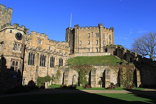
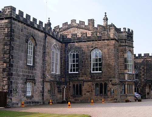
Landmarks of Durham, see each in its prime





More cities to explore
 EnglandNewcastle upon TyneExplore it in 1400 · 1860
 EnglandYorkExplore it in AD 300 · AD 950 · 1420 · 1800
 EnglandLondonExplore it in AD 200 · 1390 · 1600 · 1885
 EnglandBathExplore it in AD 100 · 1500 · 1790
Castles of Europe · Landmarks of Europe · create your own reconstruction.